All Activity
- Past hour
-
Lion’s Mane Jellyfish (Rockland, ME):

-

July 2025 Obs/Disco ... possible historic month for heat
kdxken replied to Typhoon Tip's topic in New England

-

July 2025 Obs/Disco ... possible historic month for heat
Damage In Tolland replied to Typhoon Tip's topic in New England
Trying another . Heading up the hill to house after picking up Chinese . So smoky you’d think @RUNNAWAYICEBERGwas sitting in the passenger seat with windows up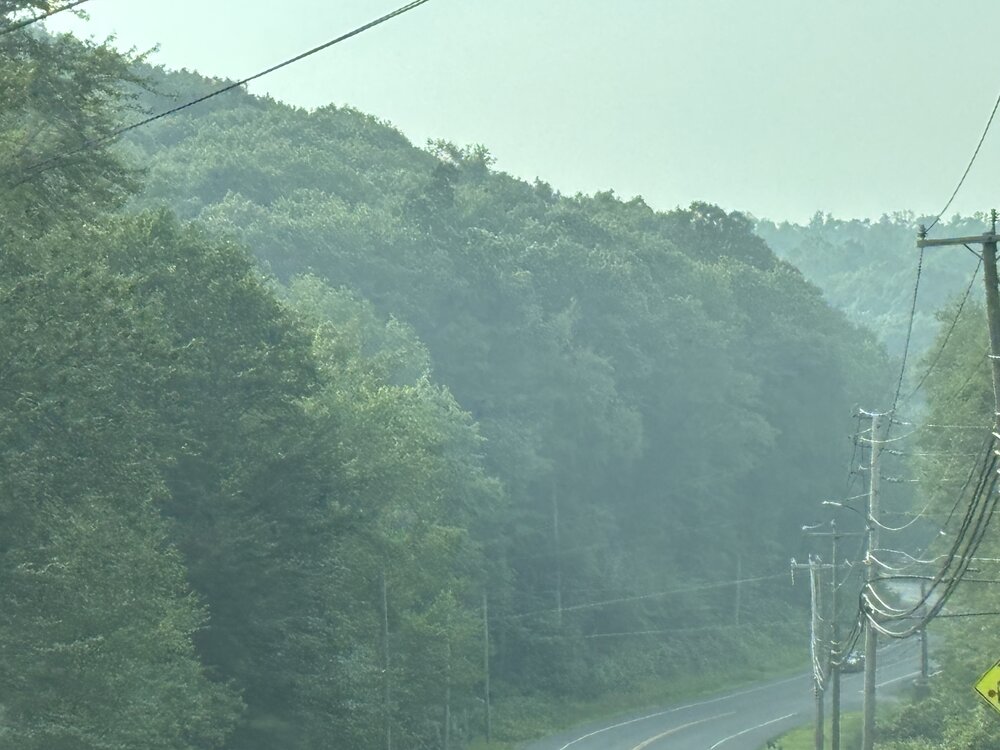
-
I guess i have to carry on without the thunderstorm. The 200mg cookie and fat joint are a lock. It doesn't feel that bad out there today. Yesterday tried to kill me but my ac trick was there lol
-

July 2025 Obs/Disco ... possible historic month for heat
Torch Tiger replied to Typhoon Tip's topic in New England

-

July 2025 Obs/Disco ... possible historic month for heat
dendrite replied to Typhoon Tip's topic in New England
What a boomer. I'm surprised he doesn't have one of those jitterbug phones. -

July 2025 Discussion-OBS - seasonable summer variability
bluewave replied to wdrag's topic in New York City Metro
JFK has a shot at their first 80° July since 2010. Time Series Summary for JFK INTERNATIONAL AIRPORT, NY - Month of Jul Click column heading to sort ascending, click again to sort descending. 1 2010 80.7 0 2 2011 79.8 0 3 2013 79.5 0 4 2025 79.3 6 - 2022 79.3 0 - 2020 79.3 0 5 2019 78.8 0 6 1999 78.7 0 - 1993 78.7 0 7 2016 78.6 0 - 1983 78.6 0 - 1949 78.6 0 8 2015 78.4 0 - 2012 78.4 0 9 1994 78.1 0 10 1955 78.0 0 11 2024 77.8 0 - 2023 77.8 0 - 2002 77.8 0 12 1995 77.7 0 13 1952 77.6 0 14 2008 77.3 0 - 1981 77.3 0 15 1971 77.2 0 -
I'm assuming @MN Transplant got hit decently too
-
July 2025 Obs/Disco ... possible historic month for heat
dendrite replied to Typhoon Tip's topic in New England
Full size iphone pics are ridiculously large image files. It's hard to even notice the difference in quality between full and large unless you expand the image. -
Amazingly, just got an inch in 50 minutes here in North Arlington. Popped up out of nowhere.
-
July 2025 Obs/Disco ... possible historic month for heat
Damage In Tolland replied to Typhoon Tip's topic in New England
I do but why should we have to resize? -
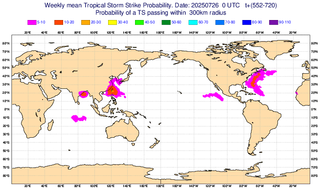
Today’s Euro Weeklies maintained an active Aug 18-24 with ~145% of 2005-24. That translates to ~13 of ACE being progged vs base of ~9. Should that week have ~13, that would imply the likelihood of an H somewhere in the basin. Where does this run imply would be the most likely general location of the track of this H? All highly speculative obviously but fwiw it suggests track may be from at or just N of N Leewards NW to either near Bermuda or W of that between Bermuda and NC and then recurving to between Cape Cod and 1000 miles E of there aiming toward Newfoundland. Midpoint of highest density of tracks starts at 20N, 60W. Then track points NW to 30N, 70W. Then NNE to 40N, 65W. Highest at risk from this prog ~Bermuda:
-
July 2025 Obs/Disco ... possible historic month for heat
dendrite replied to Typhoon Tip's topic in New England
Are you using an iphone? When you upload photos somewhere you should have the option to upload at varying sizes (full, large, medium, small). Large or medium should be good enough. -
.thumb.png.4150b06c63a21f61052e47a612bf1818.png)
July 2025 Obs/Disco ... possible historic month for heat
HIPPYVALLEY replied to Typhoon Tip's topic in New England
Might be too technical for him. -
July 2025 Obs/Disco ... possible historic month for heat
HIPPYVALLEY replied to Typhoon Tip's topic in New England
Do you have an iPhone? It’s easy to resize them. -
 Yeah not looking all that impressive
 -
July 2025 Obs/Disco ... possible historic month for heat
kdxken replied to Typhoon Tip's topic in New England
Did you check to see if any of the forecasts you made were correct before you deleted? Very unlikely but you never know. A blind squirrel and all that... -
July 2025 Obs/Disco ... possible historic month for heat
kdxken replied to Typhoon Tip's topic in New England
Resize the photo. -

July 2025 Obs/Disco ... possible historic month for heat
RUNNAWAYICEBERG replied to Typhoon Tip's topic in New England
Lol you’re so old. I DJ’d the Ridgefield Summerfest until 3. -
July 2025 Obs/Disco ... possible historic month for heat
Damage In Tolland replied to Typhoon Tip's topic in New England
Looks like most of the rains tomorrow are Pike north.. especially Pony O area to Dendy . In that zone . Shocking -

2025-2026 ENSO
michsnowfreak replied to 40/70 Benchmark's topic in Weather Forecasting and Discussion
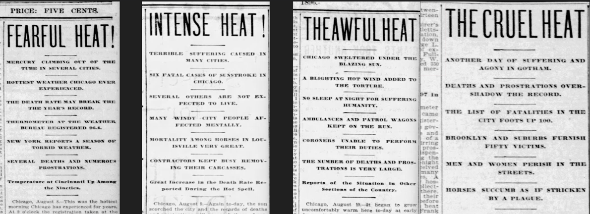
It was extra bad in NYC but it was bad in many places. Here are some headlines from the Detroit Free Press Aug 9-12, 1896
-
Tomorrow looks like the better day for storms and heavy rain with a "cold" front in the area and impressively high PWATs moving in from the southwest.
-
The mountains are too powerful for these wimpy frontal passages and shortwaves for our valleys. We need more of the forcing that we had in May and June.
-
July 2025 Obs/Disco ... possible historic month for heat
Damage In Tolland replied to Typhoon Tip's topic in New England
Test testes testicles
-
July 2025 Obs/Disco ... possible historic month for heat
Damage In Tolland replied to Typhoon Tip's topic in New England
It was full so deleted all of them.. but it still says 1 file too large so it was skipped . Which is the same thing that was happening