All Activity
- Past hour
-
GREAT! Headin' right back to another Royal Caribbean ship for a vacay.
-
It was 69 and muggy in my room.
-
Invasive and damaging. no want.
-
WHOA you guys have 45 degree dewpoints and dropped to 48 degrees last night in Dale City?! Congrats!
-
 zithromax online usa: rapidzithrodirect - where can i buy zithromax in canada
 -
I think you're splitting hairs and reaching.................first of all, I don't think that any degree of difference with respect to LE and measuring technique would negate the evolutionary advantages that Miller B type cyclogenesis has. Secondly, couple said evolutionary differences with that that Miller B also tend to be less progressive, and that negates any LEQ advantage and increased proclivity for compression that Miller A had. Would like to go through the list of Miller B captures and Miller A captures (good luck)? So, we are talking about less progressive systems on average, which protracts precp and augments measuring inconsistencies due to companion, that also tend to have the timing of approach more closely align with max rate of depending of mid level centers. Mic drop-
-
57 here. Winds keeping it from radiating much.
-
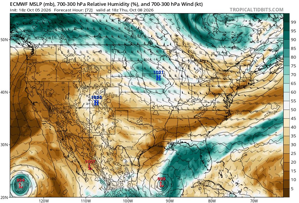
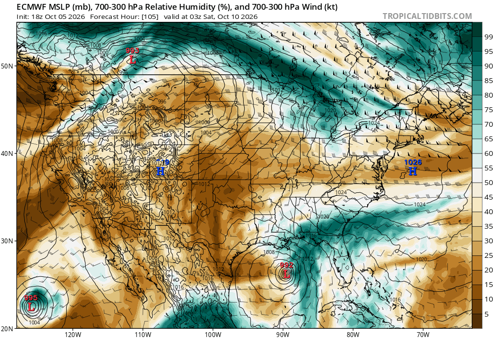
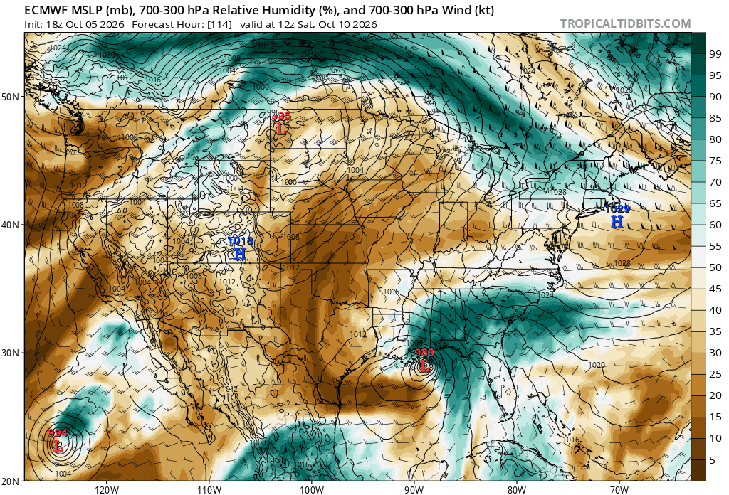
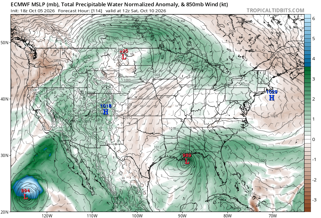
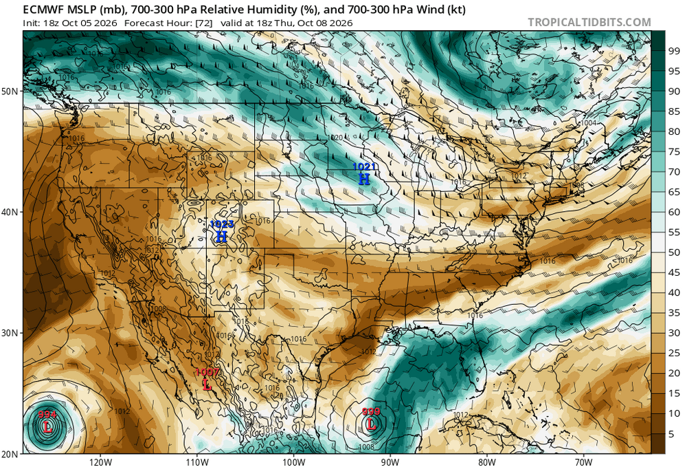
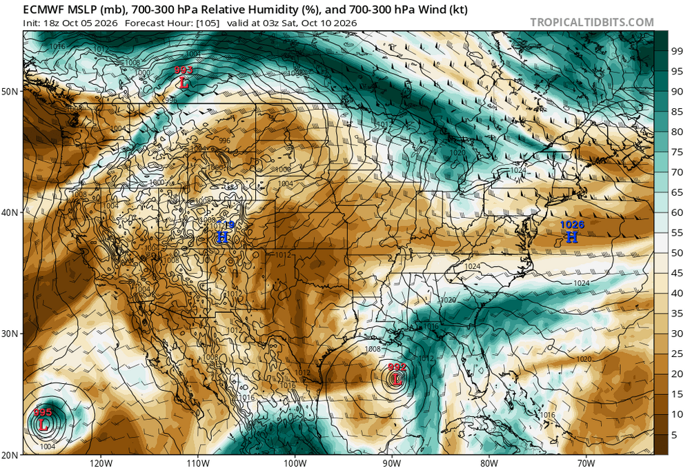
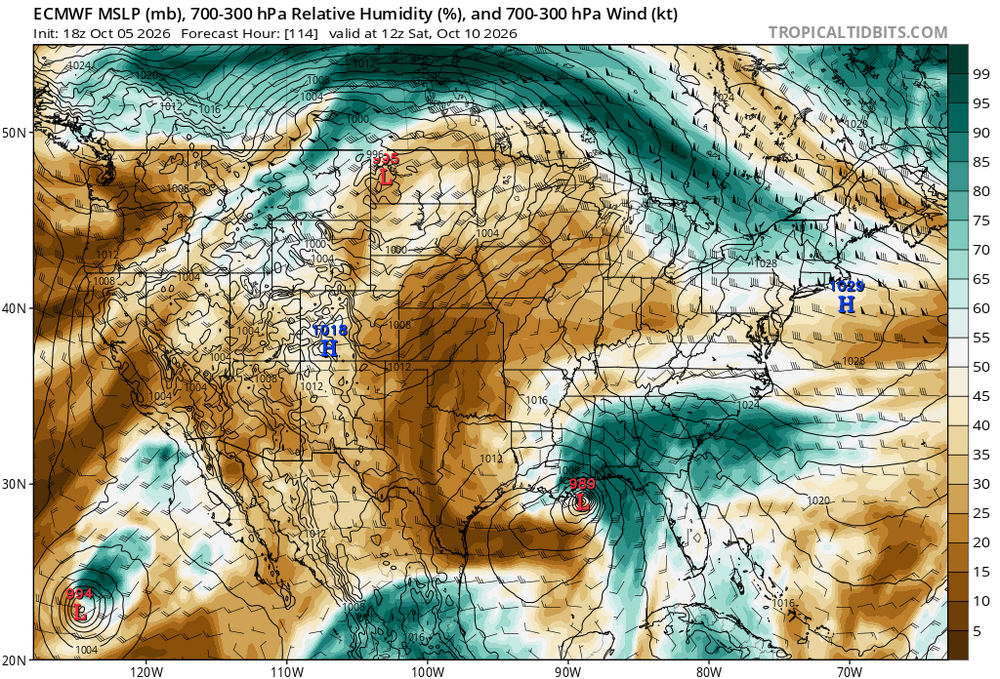
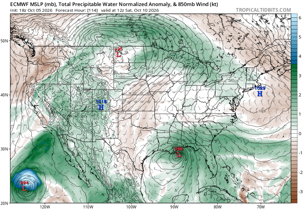
Posted this on the Tropical Forum, but will do so here b/c this could some "fun ' games" as to what is what when it comes to a TC or not! ----- Something doesn't seem right. I was surprised the 18z ECWMF suddenly went the GFS route. The 700-300 mb RH fields and PWAT anoms tell the story. I attached 18z ECMWF 72, 105, and 114 hr 700-300 RH. Even when it is still the Bay of Campeche, it is "halved" from a strong moisture gradient, and it just gets stronger w/ time. looking like a typical ET low development. And look at the 114 hr fcst PWAT anomaly. That clearly shows a frontal structure, and compare the PWAT anomalies to Simon in the EPAC. That's not nearly the anomaly you'd see in a typical TC. I can see NHC "playing games" here. Calling it something that it is not b/c of non-meteorological factors (social media nonsense, its sensible wx impact, etc). But ET low can and do form in the Gulf in Oct (see the 1992 case I posted about earlier) and given the strength of El Nino, it makes ET lows this early even more likely. In fact, by 36 hr, the 250 mb STJ become quite apparent near the Gulf Coast, and in 5 days close to landfall, a strong 250 s/w is present in the region, obviously aiding in the system's development. Some might go, "but the simulated IR from the GFS shows an eye!" Well, it is the GFS, and yes, initially it could be a TS/STS but here lies another issue, transition to a PT/ET low when it is approaching a landfall. Sandy anyone? You see the problem here. But I say, in the end, it is what it is, and call it as such. Don't let external pressures and nonsense contaminate the met science!
-
Seems to be so in the modern climate. Not so much in the "old days" . Oct. 13, 77 measurable snow in SWVA. Oct 10, 79 major snow Shenandoah valley and measurable much of MA(Orioles game). Those following Winter's turned out below avg T's and average to above Snowfall. There's several instances further back that show similar outcomes. The Latest good following was '95-96. trace amounts Oct 25 in portions of the MA and Tn Valley.
-

Invest 92L--70% 2 day, 80% 7 day odds of Development
NorthHillsWx replied to WxWatcher007's topic in Tropical Headquarters
Hurricane models overwhelmingly favor intensification into a hurricane -
I’ve turned into the old man from “Up” last ten years. I used to hope for snow/oce, now I hope for rain. Sadly, anything ocean oscillating is terrible when forecasting 7-10 days out.
-
CAR 2.5" Sep 29-30, 1991 for its first measurable snow on record in Sep. 2" at Glen NH Sep 16, 1986 as a spinner occurred at the same time in Scituate MA. @CoastalWx be like, "how can that be!?"
-
If anything, it will be a interesting year w/the addition of Brown and LeBron. Right now probably our best chance to win a championship. Not giving up on the Birds but injuries and such/O-line problems...it just may be one of those years.
-
Currently 38 in Walpack and 41 in Sandyston per NJ WXNET. Those places in the NW Sussex County valleys radiate like crazy so sub freezing likely there come Wednesday morning and close to freezing in a few spots tomorrow morning.
- Today
-
47 so far.
-
Jeez 60 here
-
30F at 3,600ft and 41F at 1,500ft… 45F here with gusty winds.
-
https://rapidzithrodirect.com/# zithromax 250 mg pill
-
One could say that Miller A having higher LEQ and lower snow ratios due to their warmer nature, they likely have more underestimation due to compaction.
-
40"+ was common N&W of BOS for 78.
-
44/37 currently. 30s tomorrow night likely.
-
Here are a couple: https://journals.ametsoc.org/view/journals/clim/33/11/jcli-d-19-0650.1.xml https://journals.ametsoc.org/view/journals/clim/31/23/jcli-d-18-0159.1.xml
-
The NW wind is crazy this evening. House shaking gusts at times.
-

Invest 92L--70% 2 day, 80% 7 day odds of Development
vortex95 replied to WxWatcher007's topic in Tropical Headquarters
From a strictly climo POV, yes, such a formation in the Bay of Campeche and intensification as a TC to the Gulf Coast happens often, but this climo is a weakness at times for AI models b/c not all follow climo or what would be more typical. -
I read a paper that Paul Roundy had shared in the last couple of years that discussed any known global impacts. Like you said, a lot if it has to be pieced together from written records from individuals in parts of the world in that time frame & then the rest from reanalysis. If I can find the paper I will share it.