All Activity
- Past hour
-

Occasional Thoughts on Climate Change
LibertyBell replied to donsutherland1's topic in Climate Change
The arguments I see politicians making is we need an all energy source approach to control costs because most people are concerned about energy costs above all else. I saw this being mentioned in the NJ gubernatorial race. To be honest, Mikie Sherill is a very poor gubernatorial candidate and if this is the best the democrats can do, no wonder they have such low approval ratings. If I have to hear *navy helicopter pilot* one more time, I'm going to destroy my TV, she might as well be a network traffic helicopter pilot for all I care and for all it has anything to do with running a state. -
Might be so violent that Ineedsnow breaks down and cries?
-
A bit. I think the month will finish a bit AN. I thought it would already have been trending up but still a bunch of BN days so far.
-
Torch cometh
-
Those will violently come up.
-
The current SSTs in the WPAC match several other years that went on to see +WPO winters
-
BOS is -2.3F MTD ORH is -1.7F I thought those departures would start trending warmer oops We fall
-
Yep. Laughs at averages dropping. Where’s Fall?
-
With a low of 42.4° this morning, the low 'round these parts has averaged 40.1° over the past 6 days. Over the same period (well, not including today) the average high temp was 75.5°. Awesome weather, just really unfortunate that the miasma of drought is dampening the vibe. River out back has been reduced to a trickle.
-

September 2025 OBS-Discussion centered NYC subforum
SACRUS replied to wdrag's topic in New York City Metro
Records: Highs: EWR: 94 (2005) NYC: 94 (1952) LGA: 93 (1952) JFK: 89 (1994) Lows: EWR: 49 (1985) NYC: 46 (1963) LGA: 50 (1985) JFK: 47 (1963) Historical: 1823: A strong category 1 or low category 2 hurricane struck near New Orleans, Louisiana and went toward Baton Rouge. Its strongest impacts occurred west of New Orleans. 1922 - The temperature at El Azizia in Libyia soared to 136 degrees to estbalish a world record. To make matters worse, a severe ghibi (dust storm) was in progress. (The Weather Channel) 1928 - Hurricane San Felipe crossed Puerto Rico resulting in the highest winds, the heaviest rains, and the greatest destruction in years. The hurricane produced much damage in the Virgin Islands, and later hit the Bahamas and Florida. (David Ludlum) 1934: The mercury soared to 92 degrees at Seattle, WA, a record for September. (The Weather Channel) 1944: Hampton Roads saw winds of 72 mph gusting to 90 mph. Richmond had 3.26 inches of rain on the 13th. Winds of 134 mph sustained with gusts to 150 mph lashed Cape Henry a wind record which remains standing today for the state.Virginia Beach saw the pressure fall to 28.80". Rainfall from the storm caused a flood of record at State Farm on the James river (26.4 feet).Damage totaled $2.5 million. Forty-six perished. This system was the first time that air force reconnaissance air craft were used to monitor a storm threatening the East Coast. Rec. Major east coast storm Sep. 13-15th 1944: The destroyer USS Warrington was sunk by the Great Atlantic Hurricane 300 miles east of Cape Canaveral, Florida. 247 men were lost in the tragedy. 1978: Little Rock, Arkansas saw 8.10 inches of rain which caused major flash flooding. Ten people were killed. 1984 - Hurricane Diana, after making a complete loop off the Carolina coast, made landfall and moved across eastern North Carolina. Diana deluged Cape Fear with more than eighteen inches of rain, and caused 78 million dollars damage in North Carolina. (Storm Data) 1987 - Showers and thunderstorms produced heavy rain in the northeastern U.S. Flooding was reported in Vermont, New York, Pennsylvania and New Jersey. Greenwood NY received 6.37 inches of rain. A dike along a creek at Prattsburg NY gave way and a two million dollar onion crop left on the ground to dry was washed away. The prolonged rains in the eastern U.S. finally came to an end late in the day as a cold front began to push the warm and humid airmass out to sea. (The National Weather Summary) (Storm Data) 1988 - Hurricane Gilbert smashed into the Cayman Islands, and as it headed for the Yucatan peninsula of Mexico strenghtened into a monster hurricane, packing winds of 175 mph. The barometric pressure at the center of Gilbert reached 26.13 inches (888 mb), an all-time record for any hurricane in the Carribean, Gulf of Mexico, or the Atlantic Ocean. Gilbert covered much of the Gulf of Mexico, producing rain as far away as the Florida Keys. (The National Weather Summary) (Storm Data) 1989 - Unseasonably cool weather prevailed over the Central Plains Region, with a record low of 29 degrees at North Platte NE. Unseasonably warm weather prevailed across the Pacific Northwest, with a record high of 96 degrees at Eugene OR. Thunderstorms over south Texas produced wind gusts to 69 mph at Del Rio, and two inches of rain in two hours. (National Weather Summary) 1993: A strong, winter-type storm moving through the Rockies and the western Plains produced record early season snowfall. Denver, Colorado recorded 5.4 inches of snow for its greatest snowstorm ever for so early in the season, after reaching 92 degrees the day before. The same record was also set at both Cheyenne, Wyoming and Scottsbluff, Nebraska with 5.5 and 2.5 inches of snow, respectively. Along with the snow came record lows including: Cheyenne, WY: 29°, Rapid City, SD: 29°-Tied, Colorado Springs, CO: 32°-Tied and Denver, CO: 33°. (Ref. AccWeather Weather History) 1994: Microburst winds of 100 mph removed the roof above 8 classrooms of the Littleton Elementary School in Cashion, AZ; 8 children/1 teacher were injured. The same storm littered the ground with golf ball-size hail and knocked down a mile-long stretch of power poles. (Ref. Weather Guide Calendar with Phenomenal Weather Events 2011 Accord Pub. 2010, USA) 1996: Hurricane Fausto moved across Baja on Friday night the 13th and continued moving north-northeastward, striking mainland Mexico early Saturday morning. (Ref. AccWeather Weather History) 1998: Heavy rain of 5 to 12 inches fell over portions of extreme southeast Kansas. Unofficial reports of rainfall amounts as high as 14 inches was reported in Bourbon County, Kansas. The hardest hit areas were along the Marmaton River in Bourbon County including Ft. Scott. The highest estimated stage of the Marmaton River at Ft. Scott reached 50.05 feet on the 14th which is the second highest stage ever recorded. (Ref. Wilson Wx. History) 1999: Hurricane Floyd on the verge of Category 5 status steamed steadily westward about 250 miles east of Miami. Forecasters warned that Floyd was much more dangerous than 1992's Hurricane Andrew due to its size. (Ref. Wilson Wx. History) 2007: Hurricane Humberto made landfall just east of High Island, TX in the McFadden National Wildlife Refuge. Hurricane Humberto had maximum sustained winds near 90 mph and a minimum pressure of 985 millibars or 29.09 inches of mercury. Humberto made history due to its rapid intensification from a tropical depression the morning of September 12th, to a hurricane early on this date, as no other hurricane has ever strengthened so quickly close to landfall. Damage was estimated near $60 million dollars. Only five other storms in Atlantic Basin history has grown from a depression to a hurricane within 24 hours: Arlene & Flora in 1963, Blanche in 1969, Celia in 1970 (from depression to a Category 3) and Harvey in 1981. (Ref. Wilson Wx. History) 2008: Hurricane Ike made landfall around 0700z along the northern end of Galveston Island, TX as a strong Category 2 storms with maximum sustained winds of 110 mph and a minimum central pressure of 28.14 inches of mercury. Prior to landfall, Ike covered an extensive area of the Gulf of Mexico with the largest radii of hurricane-force winds: 125 miles out from the center and tropical-storm force winds: 275 miles out from the center, ever measured. Much of Galveston and nearby coastal towns were left in shambles, and storm-surge damage extended well east into Louisiana. Ike resulted in 103 deaths across Hispaniola, Cuba and parts of the United States Gulf Coast and total damage at $32 billion dollars. (Ref. Wilson Wx. History) 2014: The 3rd of the top 10 US weather events according to Weatherwise magazine was the Boulder Colorado flash flood of September 9th through the 16th. This deluge dumped more than 9 inches of precipitation in 24 hours and 14 inches in four days on Colorado foothills unleashing furious flooding on Boulder and the surrounding towns. It damaged and destroyed 1800 homes, and washed out hundreds of miles of road, and cost $2 billion. (Ref.Weatherwise May/June 2013 page 15) 2017: Irma started on August 30th and reached its peak on Sep. 6th and hit FLA. on Sunday night Sep. 10th, 2017. On September 6, Irma reached its peak intensity with 185 mph (295 km/h) winds and a minimum pressure of 914 hPa (27.0 inHg), making it the strongest tropical cyclone worldwide so far in 2017. Another eyewall replacement cycle caused Irma to weaken back to a Category 4 hurricane, but the storm attained Category 5 status for a second time while making landfall in Cuba. After dropping to Category 3 intensity due to land interaction, the storm re-intensified to Category 4 as it crossed warm waters between Cuba and Florida before making landfall on Cudjoe Key with maximum sustained winds of 130 mph (215 km/h). Irma dropped back to Category 3 by the time it made a second Florida landfall on Marco Island 2018: Hurricane Florence was a powerful and long-lived Cape Verde hurricane, as well as the wettest tropical cyclone on record in the Carolinas and the ninth-wettest tropical cyclone to affect the contiguous United States. The sixth named storm, third hurricane, and the first major hurricane of the 2018 Atlantic hurricane season, Florence originated from a strong tropical wave that emerged off the west coast of Africa on August 30, 2018. Steady organization resulted in the formation of a tropical depression on the next day near Cape Verde. Progressing along a steady west-northwest trajectory, the system acquired tropical storm strength on September 1, and fluctuated in strength for several days over open ocean. An unexpected bout of rapid intensification ensued on September 4– 5, culminating with Florence becoming a Category 4 major hurricane on the Saffir–Simpson scale with estimated maximum sustained winds of 130 mph 2008: Hurricane Ike made landfall as a Category 2 storm near Galveston, Texas. 2017: The NWS Office in Reno, Nevada, issued their first tornado warning since July 21st, 2014. -
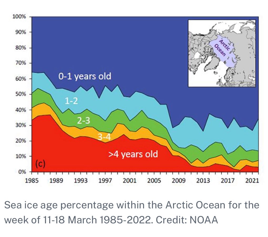
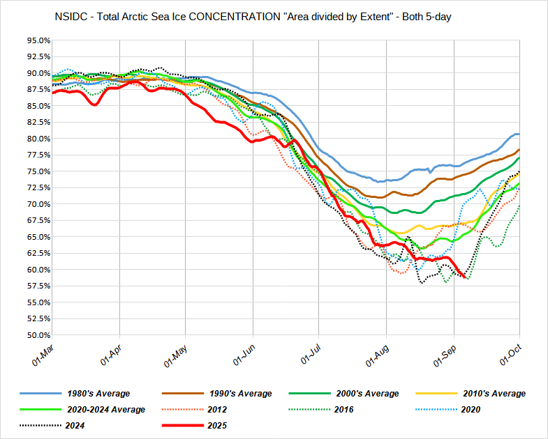
The volume is close to the lowest on record for this time of year since the ice is so thin due to the record MYI melt over the years. This allows the big disparity between extent and area. As the concentration is also near record lows. Zack Labe @zacklabe.com Follow ⚠️ While extent will not be setting any annual minimum records this year, the average thickness of #Arctic sea ice is actually at historic lows for this time of year (in the dataset by PIOMAS). Thinner ice is younger and usually more fragile. More graphics of volume: zacklabe.com/arctic-sea-i... ALT September 10, 2025 at 8:07 AM Everybody can

-
A classic just in time rain Edit, surprisingly good boomers
- Today
-
September 2025 OBS-Discussion centered NYC subforum
SACRUS replied to wdrag's topic in New York City Metro
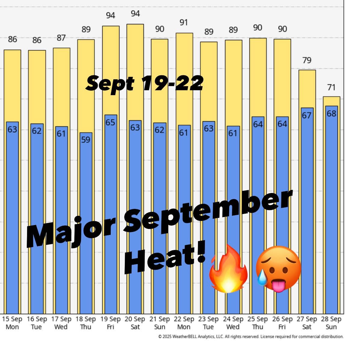
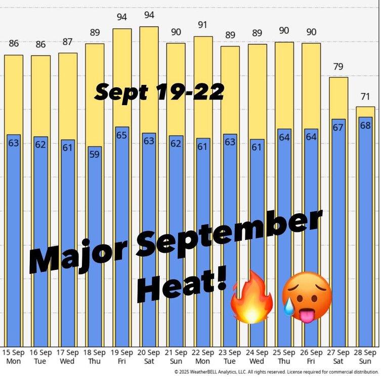
58 / 56 - partly sunny today. Upper 70s / low 80s. Overall warmer the next week / through Friday. Onshore pushing in along the coast, ridge above and cutoff below into the SE with ridge north. Warmest days Sun (9/13) and Fri 9(19) mid 80s in the hottest spots perhaps warmer. Mid week cut off ULL is in the SE / GFS more north so perhaps clouds and showers making it north, especially in southern section. Looks like we have some semblance of a cut off / front come through from the GL/MW next weekend 20-21 and a brief period near/below normal. Overall warmer beyond there. -

Occasional Thoughts on Climate Change
donsutherland1 replied to donsutherland1's topic in Climate Change
Global energy demand is rising faster than renewables can scale. Population growth, economic development, and industrial expansion in emerging markets are driving electricity and fuel consumption to record highs. Although solar and wind power generation is growing at double-digit rates, they are adding to energy supply rather than displacing fossil fuels. Political headwinds ranging from a u-turn on climate policy in the United States and retreat from climate ambition in the European Union will likely prolong, if not increase, the excessive consumption of fossil fuels. Unfortunately, at least for the near-term on account of an absence of political will, macroeconomic shocks such as those resulting from the 2008 financial crisis and 2020-21 COVID pandemic may be the only sources of reductions in fossil fuel burning and greenhouse gas emissions. All indications I have seen so far suggest that COP 30 in Brazil will be another farce. There will be empty words, but no binding commitments to even beginning a phase-out of fossil fuels, much less commitments with credible targets and an enforcement mechanism. In sum, the world's leaders have committed to bringing the planet to a new climate epoch. That this will mean sacrificing parts of major cities to the seas or parts of Europe to a chill from the breakdown of the AMOC doesn't deter them. The most relevant question concerns whether they have chosen the Mid-Pliocene or the even hotter Eocene. With approximately 3°C warming likely by 2100 on the present course, the Mid-Pliocene might merely be a stop along the way of an longer journey into a hotter climate. -
Yes, that was a big part of HM’s disco on this topic (-QBO/-ENSO resulting in a flat Aleutian ridge and +QBO/-ENSO resulting in a poleward Aleutian high). He actually went into a very detailed disco with a bunch of images in his blog. Shame I can’t find it anymore to share on here
-
I did some digging and turns out it’s something called “rain”. It’s a relatively common weather phenomenon across some parts of the world. Exciting to see it so close by!
-
Getting the first glimmer of leaf change in the usual low lying, wetland area.
-
There are a lot of green, yellow and orange returns showing up on radar in southeast Wisconsin. I’ll investigate what it could be.
-

September 2025 OBS-Discussion centered NYC subforum
bluewave replied to wdrag's topic in New York City Metro
MPO made it down to 41° at the end of August which was the coldest since 2000. But not really that cold prior to 2000. The drier conditions allowed them to make it to the 11th coldest reading for August. The warmth back in June was more impressive. It was their first June 93° maximum temperature. Time Series Summary for Mount Pocono Area, PA (ThreadEx) - Month of Aug top 10 lowest temperatures Click column heading to sort ascending, click again to sort descending. 1 1986 31 0 2 1965 32 0 - 1907 32 0 3 1987 33 4 - 1941 33 0 - 1940 33 0 4 1982 34 0 - 1976 34 0 - 1942 34 0 - 1923 34 0 - 1910 34 0 - 1908 34 0 - 1904 34 0 5 1979 35 0 - 1921 35 0 - 1916 35 0 6 1972 36 0 - 1971 36 0 - 1968 36 0 - 1934 36 0 - 1927 36 0 - 1912 36 0 - 1911 36 0 7 1992 37 4 - 1989 37 6 - 1988 37 5 - 1963 37 0 - 1947 37 0 - 1946 37 0 - 1922 37 0 - 1915 37 0 - 1909 37 0 - 1905 37 0 - 1903 37 0 8 1981 38 0 - 1977 38 0 - 1930 38 0 - 1924 38 0 - 1919 38 0 9 1969 39 0 - 1964 39 0 - 1949 39 0 - 1944 39 0 - 1935 39 0 - 1906 39 0 - 1902 39 0 10 2000 40 0 - 1974 40 0 - 1966 40 0 - 1962 40 0 - 1952 40 0 - 1950 40 0 - 1936 40 0 - 1929 40 0 - 1917 40 0 11 2025 41 0 - 1984 41 0 - 1983 41 0 - 1958 41 1 - 1957 41 0 - 1954 41 2 Time Series Summary for Mount Pocono Area, PA (ThreadEx) - Month of Jun warmest maximum temperatures Click column heading to sort ascending, click again to sort descending. 1 2025 93 0 2 1952 92 0 - 1933 92 0 - 1914 92 0 3 2011 91 0 - 1911 91 0 4 2012 90 0 - 1964 90 0 - 1957 90 3 - 1956 90 0 - 1953 90 0 - 1908 90 0 5 2021 89 0 - 2008 89 0 - 1944 89 0 - 1943 89 0 - 1934 89 0 - 1925 89 0 6 2024 88 0 - 2023 88 0 -
What a week coming up.. Next week looks dry and unseasonably warm with highs in the 80s inland! Summer is not over yet! Keep the pools open and the boats in the water.
.jpg.8f99922b8a0dc1b5f14ce8f6e0260c04.jpg)
-
.thumb.jpg.6a4895b2a43f87359e4e7d04a6fa0d14.jpg)
Central PA Banter (Banter Less?) Thread
Yardstickgozinya replied to Itstrainingtime's topic in Upstate New York/Pennsylvania
https://youtu.be/azE7nqqQMmo?si=etqrdvu28PyzRfE3 -
Lol
-
haven't mowed my lawn in probably two weeks - it would be mostly running over walnuts anyway. seeing lots of trees starting to pop with color, especially near the lakes on my way to work in the morning. patchy fog has been the most exciting part of the past five days otherwise.
-
Upstate heatwave
-
We’ll get it briefly in early nov and probably early April as a few mangled, fat flakes and as usual, everything in between will be variations of chilly and warm rain, mixed in with occasional periods of 65 degree mist and fog. Of course, northern New England is a whole different realm so you know they’ll have their many moments of glory.