All Activity
- Past hour
-
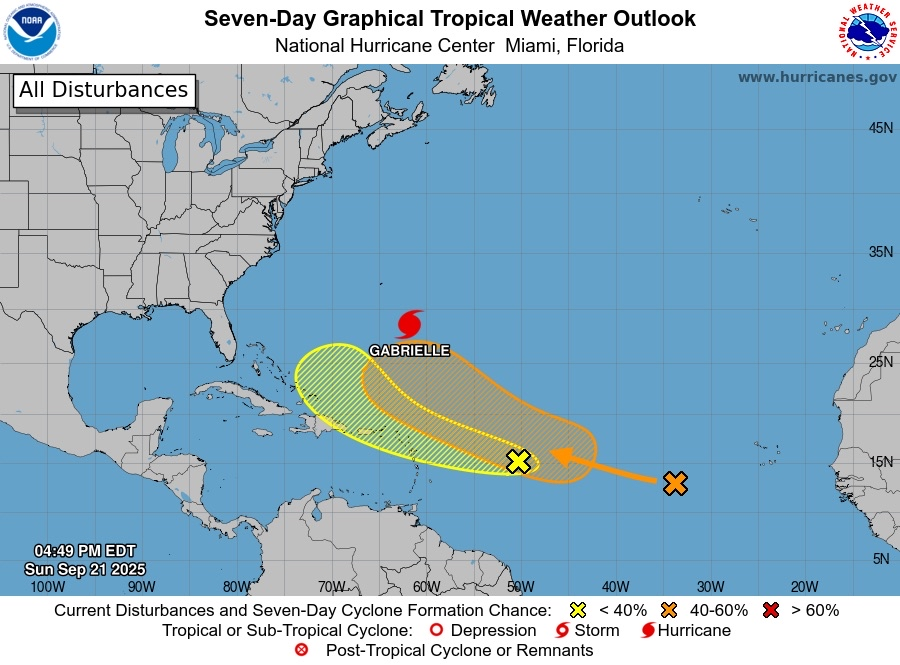
It may be starting to take off with deep convection now wrapping fully around the center. It has a narrow window before environmental conditions become more hostile but the once anemic Gabby may put on a show before the curtain falls.
-
 It’s a spectacular system
 - Today
-

-
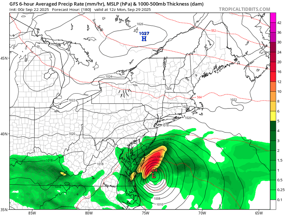
Gfs
-
 Ragasa's massive eye takes up almost an entire degree of latitude and longitude
 -

September 2025 OBS-Discussion centered NYC subforum
psv88 replied to wdrag's topic in New York City Metro
49.9. Chilly morning incoming -

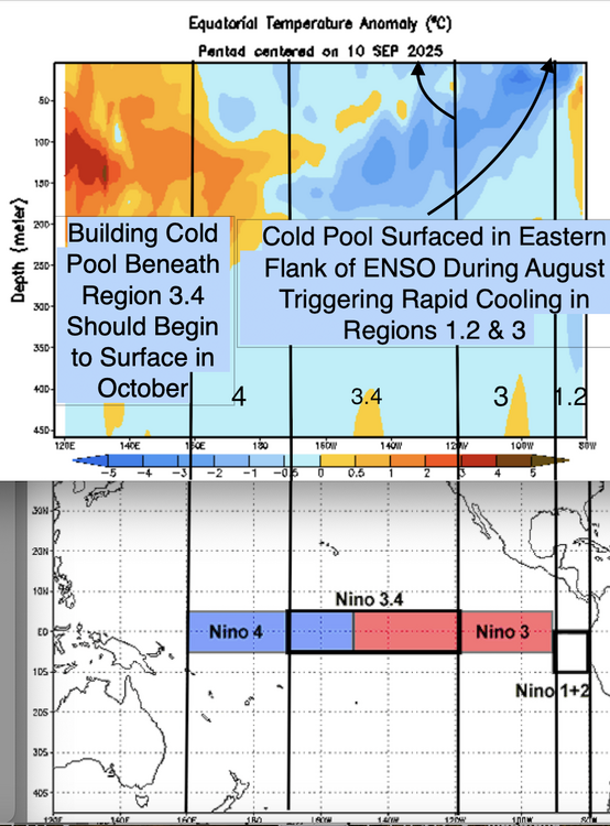
2025-2026 ENSO
Daniel Boone replied to 40/70 Benchmark's topic in Weather Forecasting and Discussion
That would be a nice repeat around here. Record cold and snow late November with average Snowfall the rest of Winter. The following Winter was horrendous as we all know. Only significant Snowfall (greater than 4") was in March. -
A lot of that is just stupid…the early Sep dots in the Mid Atlantic….Nov dots in NNE.
-
Yeah, and those cold waters around Newfoundland. The West Pac is once again looking like a Thorn . So, rather competing Driver's. There'll probably be a large area of Ridging in the entire North Pacific this Winter. Probably will be shifting of the main core from West to East occasionally, or a split. Hopefully, we can keep decent ridging in the NEPAC and into AK and Yukon from the NEPAC warm SST'S. That is if you are Winter Wx Lover's. There should be blocking Episodes due to the cold pool around Newfoundland being conducive for 50-50 LP hangout there. QBO is a Mystery component this Winter imo. Up for debate since the SST Configuration and ENSO Status may alter it's affect one way or the other. Solar Flares and Sunspots may play a Role as well.
-
Wound up with almost a half iinch here today. A Station just east of Sneedville recorded 3.17 inches !
-
Euro is also a step to the gfs
-

-
Scored two thunderstorms within a couple hours of each other tonight. Best rains were west and south of me but I still managed about 3/4 of an inch.
-
Happy Birthday
-
-

2025-2026 ENSO
Stormchaserchuck1 replied to 40/70 Benchmark's topic in Weather Forecasting and Discussion
I made this graph last year, it's a smoothed out AMO index since it went positive in 1995. It appears that we still seem to be in a rising phase, over the long term. Also, the NAO has been very positive May-Aug, just like last year. Such +NAO in the warm season has a -0.3 SSTA correlation in the south-central Atlantic. A lot of the cool water this year is because of such a strong +NAO... It's been positive 8 of the last 9 months. If the NAO had been negative 8/9 months, you'd be seeing some very warm SSTAs in the Tropical Atlantic, and probably more activity this hurricane season. -
TWN had storms honed for my region, they formed elsewhere just to my east like 2-3 years ago that one summer they spawned just miles east every time. Kitchener got some and this MCS appeared to bow out a bit after the city. It was heavy rain cells with thunder I presume but one gained just east of downtown Toronto. Liked the air out there today, 27C. Fantastic summer all around.
-
I'm not. I have a very big party for my father and mother-in-law for their 80th birthday next Saturday. I have about 40 to 50 people coming.
-
37.2 this AM.
-
True. There is a clear warm migration in the reliable station data regardless of the images. The resolution change between the maps just left a bit to be desired in the comparison. I assumed the first map was biased cool because of smoothing in some areas, like the NH sea coast.
-
Now, maybe these trends reverse and guidance will be wrong, but that is not what we are seeing now. It's not becoming less east-based.
-
Also, if you look at guidance, this has been expected and well forecast.
-
Yes, I think Jerry is focusing on region 3...while 1.2 is volatile....this marked cooling in that zone isn't a function of volatility. If you have been paying attention, the subsurface cold pool emerged due to sustained trades.
-
No; it invalidates it. The eastern zone of 1.2 began warm and the subsurface cold pool emerged there.
-
There’s definitely a big jump between the 2. Losing the 70s and 80s really extends the growing season. But there’s some lousy COOP sites in there that result in polka dots.


