All Activity
- Past hour
-
Snowman19 seeing this post.

-
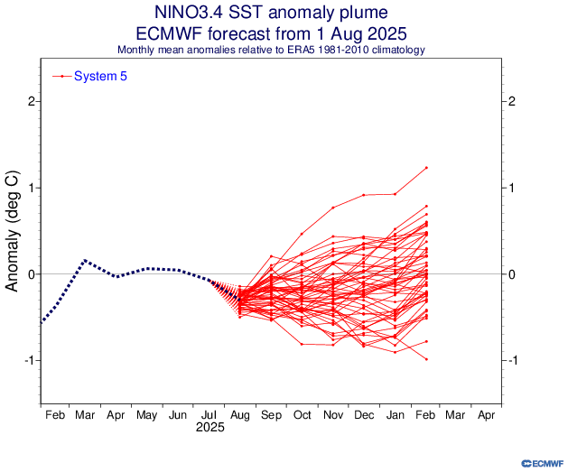
I just found Sept 2M forecasts for Dec and Jan individually though not Sept for DJF: https://charts.ecmwf.int/products/seasonal_system5_standard_2mtm?area=NAME&base_time=202509010000&stats=ensm&valid_time=202510020000 @donsutherland1@mitchnick
-

2025 Atlantic Hurricane Season
BarryStantonGBP replied to BarryStantonGBP's topic in Tropical Headquarters
Now GDM has 91L "Gabby" reforming in the subtropics "Humberto" becomes long track CV major "Imelda" goes for the gulf -

2025-2026 ENSO
donsutherland1 replied to 40/70 Benchmark's topic in Weather Forecasting and Discussion
It was. Notice how similar the map looks to last September's outlook for the past winter. I suspect that the similarity reveals that the expected ENSO state plays a disproportionate role in the seasonal forecasts. -
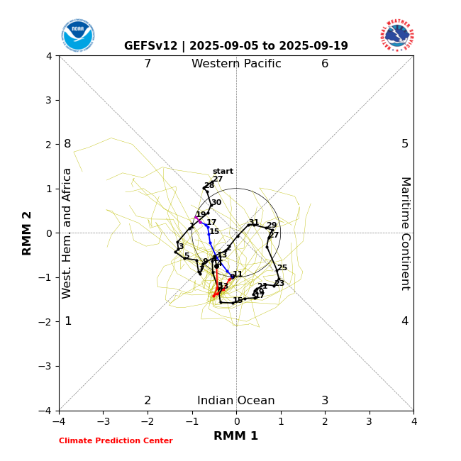
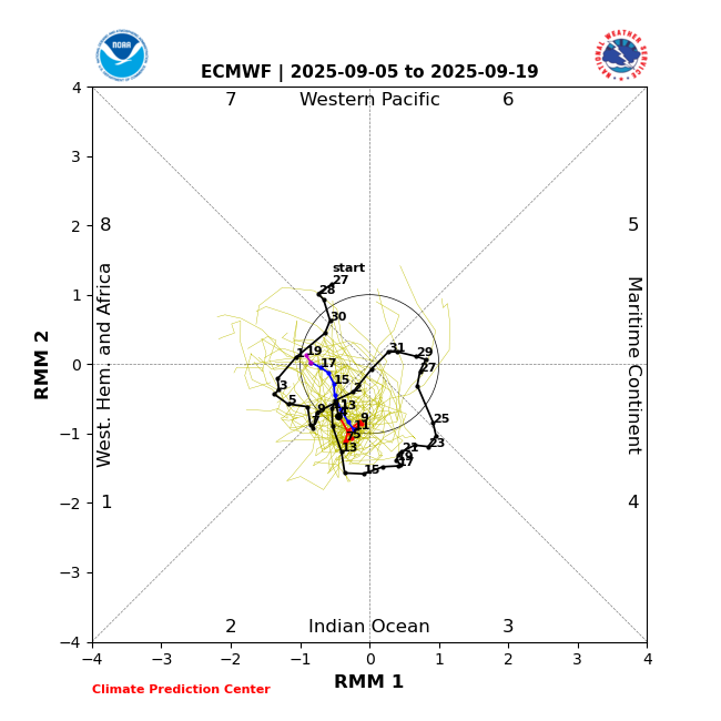
In addition: The last few GEFS and EPS runs have forecasted MJO in the relatively favorable phases of 2, 1, and 8 through Sept. 19 and this would probably extend at least through the rest of Sept per longer term model guidance and climo:
-
September 2025 OBS-Discussion centered NYC subforum
donsutherland1 replied to wdrag's topic in New York City Metro
Overnight, New York City saw its biggest one- and two-day rainfall since August 20 and August 20-21. The guidance has continued to increase rainfall amounts for later Saturday into Sunday with some of the guidance showing the potential for an inch or more of rain in places. As a result, this could be New York City's biggest rainfall since 2.64" fell on July 14. That rainfall was highlighted by an hourly figure of 2.07". September 6 will also be the 17th anniversary of a widespread rainstorm that produced daily record figures across the New York City region and nearby southern New England. Daily records set in 2008 included: Bridgeport: 2.90" Danbury: 5.96" Hartford: 5.22" Islip: 2.29" New Haven: 3.31" New York City-Central Park: 3.26" New York City-JFK Airport: 2.51" New York City-LaGuardia Airport: 3.21" Newark: 3.64" Poughkeepsie: 2.20" Providence: 3.95" Westhampton: 2.32" White Plains: 4.42" In terms of temperatures, tomorrow will be another warm day. Temperatures will top out in the lower and middle 80s before another cooler air mass moves into the region. A few of the warmer spots could top out in the upper 80s. Following the passage of a strong cold front, temperatures will mainly top out in the 70s during the daytime and fall into the 50s at nighttime in New York City through at least the middle of next week. Additional showers or rain is possible around midweek. The ENSO Region 1+2 anomaly was -0.3°C and the Region 3.4 anomaly was -0.4°C for the week centered around August 27. For the past six weeks, the ENSO Region 1+2 anomaly has averaged +0.33°C and the ENSO Region 3.4 anomaly has averaged -0.32°C. La Niña conditions will likely develop during mid- or late-autumn. The SOI was +17.71 today. The preliminary Arctic Oscillation (AO) was -0.231 today. -

September 2025 OBS-Discussion centered NYC subforum
weatherpruf replied to wdrag's topic in New York City Metro
you never know; i went out on the sound porgy fishing last year in early oct or so and just threw some ice in a bucket; it got so hot by noon the ice melted and i had to scramble lest the fish spoil; had to empty out the food cooler and toss the fish in the remaining ice; as it was a soft cooler, ice is a no no and it leaked out all the way home, which was a 3 hour ride back to nj.... -
Do you or does anyone else have a link that can be provided to past years’ Euro Sept 2m temperature forecasts going back however far they do for the respective upcoming DJFs for North America or the US? Edit: I found it kind of sort of. See post below. @donsutherland1@mitchnick
-

September 2025 OBS-Discussion centered NYC subforum
Stormlover74 replied to wdrag's topic in New York City Metro
Made it to 87 here -
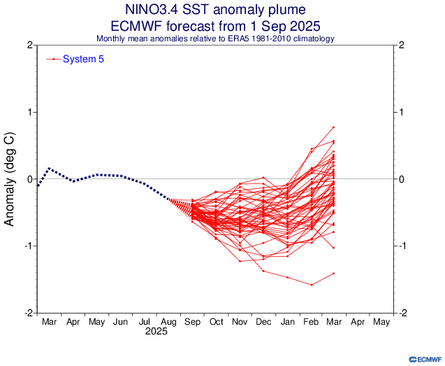
The new Euro has DJF Nino 3.4 much cooler than last month with it at ~-0.50 vs last month’s -0.08: 8/1/25 Euro prog for DJF: -0.08 9/1/25 Euro prog for DJF: ~-0.50
-
To be clear 91L still has a chance. I’m more skeptical about a CAG especially mid month. That’s outside of climatology as @GaWx has noted. Late month and especially into October is prime time for that though. Anyone thinking we’re in for a quiet season because of conditions currently should look at what was posted earlier. This decade especially has been known for strongly backloaded seasons.
-
NHC drops from 90% to 70% for the SE Atlantic stuff
-
Good point—there was also a pretty big fail on genesis with Fernand.
-
Unfortunately, the 18Z joined the east trend. We *may* still be in the game along the 95 corridor in Maryland, but we’re running out of wiggle room. On the positive side, most guidance has a signal for some anafrontal rain, either during the late evening, overnight, or early Sunday hours.
-
Saco at Cornish, Maine is at 269 cfs. The listed low is 295 in 1995. Sandy River at Mercer is 57.1 cfs. Record low is 38.7 in 2002 while the 25th percentile is 86. August 2002 Was the driest with 0.88", and Jan-August was 3rd lowest. (Lowest J-A came the next year but Sept-Dec dumped more than 27", 57% of the year's total.)
-
Of course climate change is having an effect on certain things. Did anyone say it isn't? We can still acknowledge that and also acknowledge that directly attributing disasters like hurricanes, tornadoes, floods, etc to climate change is not a scientific endeavor. Now, if research shows that certain events are statistically becoming more common across large regions over a significant period of time that correlates to climate change (and there is a physical reason for it that also corroborates) then you have a starting point. Give nuance a chance. Or don't. I don't have much patience for those that adopt a rigid, religious, dogmatic mindset.
- Today
-
Nah, Moregarbage broke the back on July 11th.
-

2025-2026 ENSO
michsnowfreak replied to 40/70 Benchmark's topic in Weather Forecasting and Discussion
Pretty big fail last winter. -
Occasional Thoughts on Climate Change
donsutherland1 replied to donsutherland1's topic in Climate Change
I agree. At some degree of warming or ocean acidification/deoxygenation, the food chain dominoes will begin to fall. The precise levels where this will occur are uncertain. Even if they were well-established, I don't think that knowledge, alone, would galvanize human society. Unfortunately, if past extinction/mass extinction events are representative, once the food chain dominoes begin to fall, it will be too late to mount an effective response. -
I was largely agreeing with your point. But it's also fair to point out that because singular events cannot singularly be attributed to climate change, telling people that catastrophic floods are now 15% more likely in their area isn't going to move the needle. And of course, the science is still very much unsettled on exactly how climate warming is affecting natural disaster frequency, severity, etc. So it will likely take something much larger scale and non-singular to affect political/social change of mind.
-
Welp, 94 currently. Awesome pool Day!
-
In 150 years of record, 80 saw temps of 80F+ in October. So while not common to get many, getting 1 or 2 is fairly normal. The most consecutive years with 80F+ in October is 6 years (1958-1963), and the most consecutive without hitting 80F is also 6 years (1885-1890).
-
Occasional Thoughts on Climate Change
donsutherland1 replied to donsutherland1's topic in Climate Change
Yes. At present, for most crops, gains in production outweigh declines in production. I suspect that modern agricultural practices are helping increase yields at present more than anything else. That could begin to change in coming decades assuming that technological advances don't offset adverse impacts from drought/heat/flood events. With regard to the Midwest, I suspect that the widespread use of irrigation has allowed for greater moisture than would otherwise be the case. That has played out in higher humidity, less frequent droughts, and less intense heat than during the Dust Bowl era there. But even those benefits could be temporary at some degree of additional warming. -
0.66” here.
-
For tomorrow afternoon/evening. a section of Upton’s AFD, Area Forecast Discussion National Weather Service New York NY 359 PM EDT Fri Sep 5 2025 SHORT TERM /6 AM SATURDAY MORNING THROUGH SATURDAY NIGHT/... A cold front will likely bring a round of severe weather to the area on Sat. With sufficient moisture and daytime heating, SBCAPE is modeled to increase to around 2500 J/kg during the day on Sat from approximately NYC to points N and W, including wrn CT. Veering winds with height, with about 40kt at h85, yield a BRN around in the 15-30 range, indicating organized development with the potential for some supercells. Damaging winds possible in any of these areas with the cdfnt providing focus by 16-18Z. In addition, 0-3km ehi over 6 from near POU swwd thru the cwa indicates a tor risk as well. SPC has the area in a slight risk, and the gridded fcst includes severe wording along with the hwo.


