All Activity
- Past hour
-
And one less hour of diurnal heating! Seriously, I see that in the spring when chase season ramps up...one extra hour of heating! I'd like to say it just trolls or engagement bait, but not always.
-
@CoastalWx needs to be reminded that in very strong El Nino winters, the only real cold air shots for the CONUS are in the Northeast!
-
You'd be the one squealing. I got the bow
-
How about "Downeaster?" as in Alexa!
-
2026-2027 Record-breaking El Nino
BuffaloWeather replied to Stormchaserchuck1's topic in Weather Forecasting and Discussion
"Weaker Super Ninos". Average snowfall at BUF airport is 95.4", my call is for around 50". 2015-2016 had 55.1" -
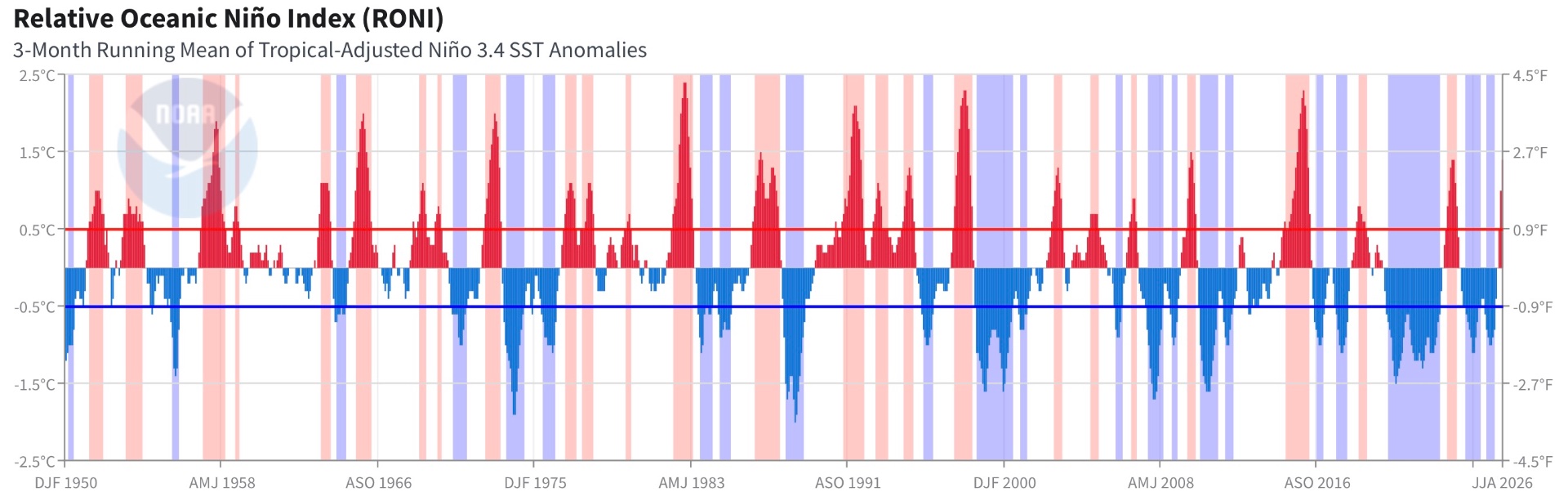
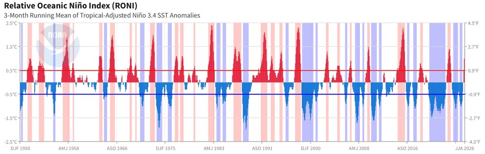
Quite consistent pattern w/ very strong El Nino. The biggest temp anomalies are usually in the Upper MS Vly/Nrn Plains and that's is what this shows well here. All on track. That what the MSM and others do not get. Sure, this type is El Nino is not common, but 1) just b/c something is not common or rare does not mean it is abnormal, 2) very strong El Nino in itself occurs naturally. and 3) the sensible wx that results from it in regions across the globe are completely what is to be expected given other El Ninos like this. This a major problem these days w/ how things are communicated. Everything is pushed as NOT usual or typical simply b/c it has societal and environment impact. As if there should never be any or not times it is worse than others? Has the ATLC HU season been severely suppressed? Yes, Pacific HU season very active? Yes. STJ showing dominance? Yes. Big rains srn Cali and Desert SW? Yes. Miller A tendencies E Coast? Yes. I see narrative pushed that due to warming, the wx is becoming more "unforecastable" or "uncertain." Noting could be further from the truth! And this notion that El Nino gets "worse" w/ warming. So why in the last 30 years, base conditions have become more La Nina? See attachment. I was thinking it may be AMO connected, but it was more El Nino base 1950-1969 when we were still in the favorable AMO phase for big ATLC HUs, and since 1995 that same AMO phase for ATLC HUs has existed, yet more base La Nina, so any direct correlations do not work here.
-

2026-2027 Record-breaking El Nino
forkyfork replied to Stormchaserchuck1's topic in Weather Forecasting and Discussion
that's me -
Winter thoughts https://www.facebook.com/share/1N3iXRz76y/?mibextid=wwXIfr
-
Thoughts on winter https://www.facebook.com/share/1N3iXRz76y/?mibextid=wwXIfr
-

2026-2027 Record-breaking El Nino
rclab replied to Stormchaserchuck1's topic in Weather Forecasting and Discussion
forky ? As always …… -
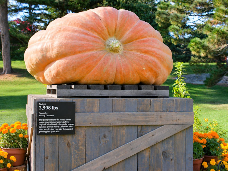
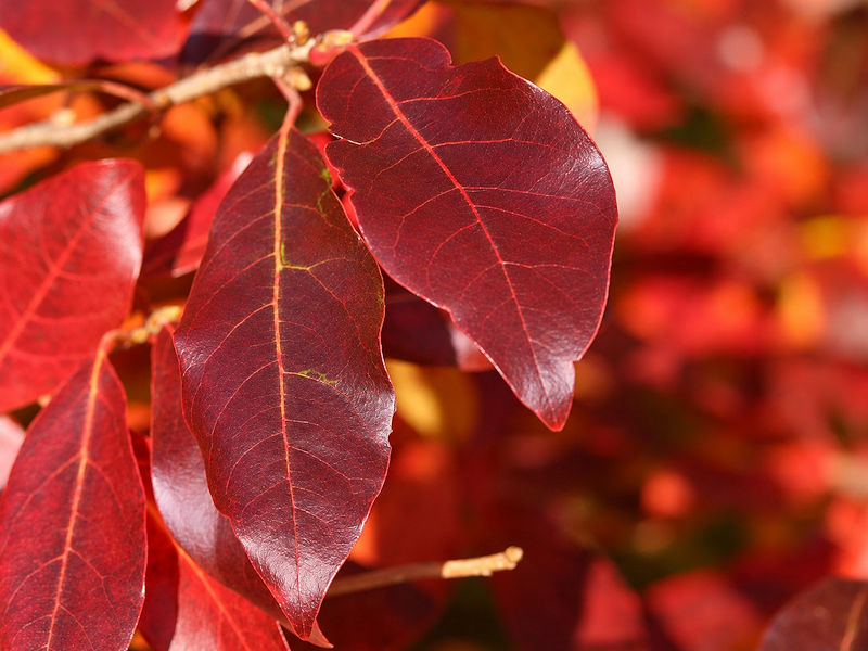
Six photos from the New York Botanical Garden where the annual Chrysanthemum show opened today:



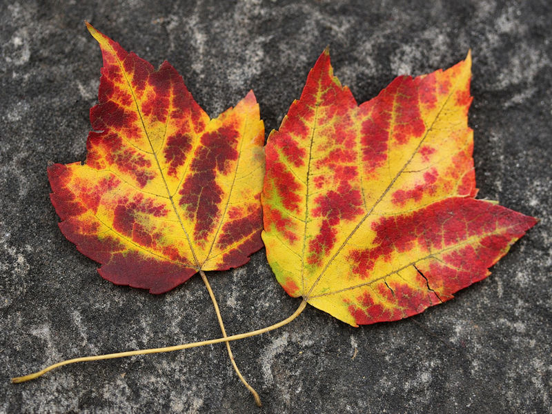
-
2026-2027 Record-breaking El Nino
forkyfork replied to Stormchaserchuck1's topic in Weather Forecasting and Discussion

-
enjoy the nice weather
-
what a winter
-
not 1" due to the wind, correct? :x
-
Latest 1” depth at the Mansfield summit stake since 1954 was 11/9/1985. I feel like we are going to beat that. This super Nino fall going to set the latest 1” snowfall at the Mansfield summit station?
-
@CoastalWx wants another "Wild Turkey Surprise" on Thanksgiving like what happened in 1989. A kiddie Scott went to bed that evening mad b/c the snow was going to miss SNE, and when woke up the next morning to S+ and got nearly a foot in GHG! Does he even recall this event? Big fcst bust. Looked too cold and suppressed. Models no clue. I recall the NWS took down the Winter wx advisory for the S Coast for their 06z update. Then the first obs from BDR at 10z (they were not 24 hr then) had S+ and then quickly put up a winter storm warning!
-
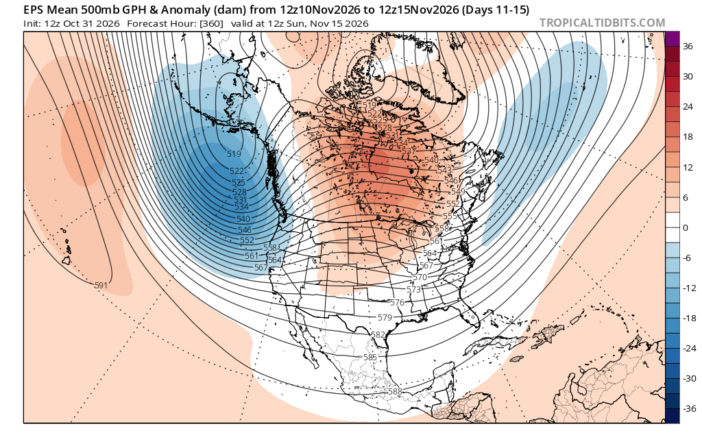
I will say, with that absolute BLASTING of the pac jet (lol DT) there must be some jet splitting there, probably a bunch of junk systems/late-bloomer ots systems. 11/10-25? Just a guess from that overall look I saw. Maybe some backside cold/snow-flurries NNE type thing. eventually something would produce there
-
The annual record was set in 1979, when IAD precipitation exceeded DCA precipitation by 8.10 inches. So, we are on pace to break that record in 2026, with the current IAD minus DCA difference being 8.91 inches. Interestingly just five years ago, DCA precipitation exceeded IAD precipitation by a record 9.13 inches.
- Today
-
2026-2027 Record-breaking El Nino
LakePaste25 replied to Stormchaserchuck1's topic in Weather Forecasting and Discussion
Bank on it. If you look at @EasternLI’s H5 maps from 1877-78 (the extreme east based El Niño event) it’s basically a persistent -TNH from Nov-March. -

2026-2027 Record-breaking El Nino
snowman19 replied to Stormchaserchuck1's topic in Weather Forecasting and Discussion
Agree. IMO this ends up a strong -TNH winter -
I wonder if there has been another time with IAD so far up on DCA for precip.
-
2026-2027 Record-breaking El Nino
LakePaste25 replied to Stormchaserchuck1's topic in Weather Forecasting and Discussion
Granted, I don’t think it’s *too* far off with the monthly H5. But a Feb -EPO in the monthly mean probably isn’t happening IMO. -
2026-2027 Record-breaking El Nino
LakePaste25 replied to Stormchaserchuck1's topic in Weather Forecasting and Discussion
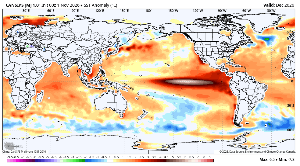
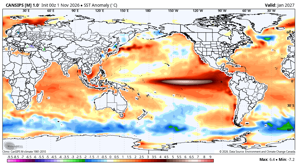
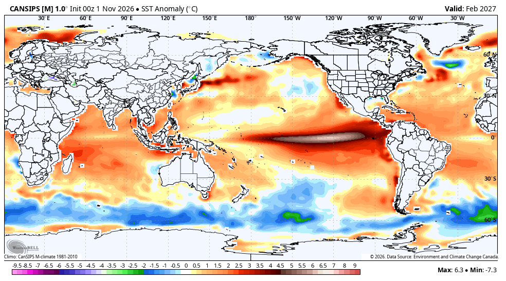
We’re at the point where it *finally* initialized the next month (November) correctly as an east-based event. But once again it tries to go “super Modoki” the following months which I don’t think is accurate.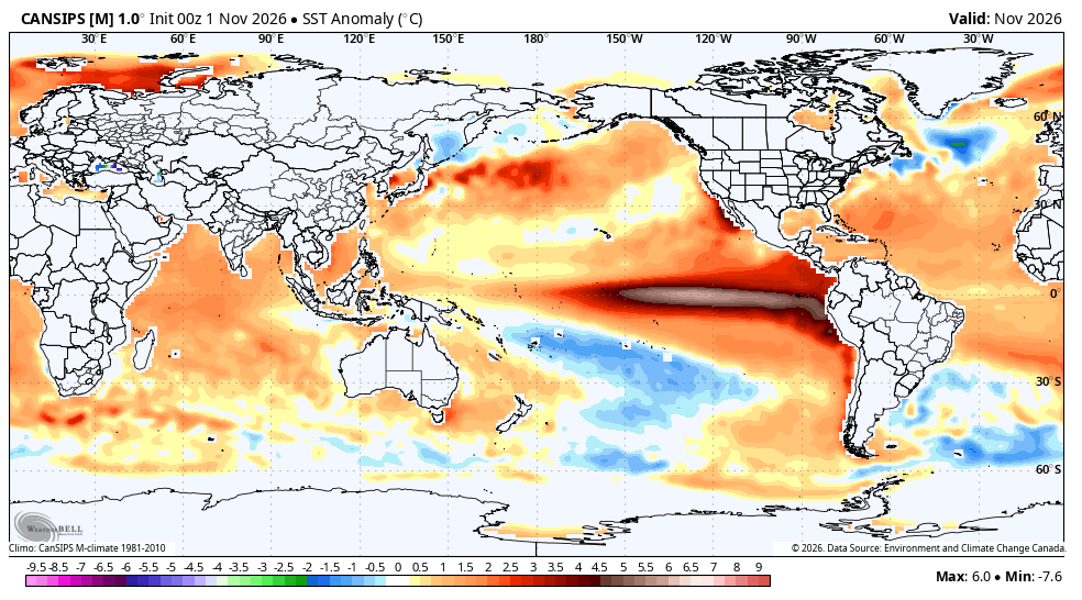
-
My Dec. 14th prediction would also come into play. I picked that date because it was my parent's anniversary, my dad and brother's birthday. Very scientific.