All Activity
- Past hour
-
Looks amazing here
-

2/22-23 "There's no way..." Storm Part 2
Stormchaserchuck1 replied to Maestrobjwa's topic in Mid Atlantic
21z RAP has me getting 15-18" -
Could be going somewhere for snow, thunder snow, coastal flooding and wind... I would say montauk or Nassau County..
-
people say you should not wait til the storm ends to clean....but you can't operate a snow blower in most towns before 8 am....
-
-
-
Thoughts? Low-end totals in NYC? https://x.com/matthewcappucci/status/2025349537158627733?s=46&t=vSc28c4jRnGy3UkOwCbIQQ
-

“Cory’s in NYC! Let’s HECS!” Feb. 22-24 Disco
Sey-Mour Snow replied to TheSnowman's topic in New England
What your recollection of 1978 compared to this? There are surface maps floating around comparing this to the surface map of 78 with a 1049 high in the same exact spot in Canada and a stronger storm this go around in the same spot. -
Can we stop talking about LA Nina? Thanks.
-
there was nothing a month ago. if it snows in december, forget it. i'm just hoping my snow blower holds up with its shaky tire; a month ago i could not get it repaired in a timely fashion; it froze during the last storm and didn't work at all. once it warmed up it was working again.
-
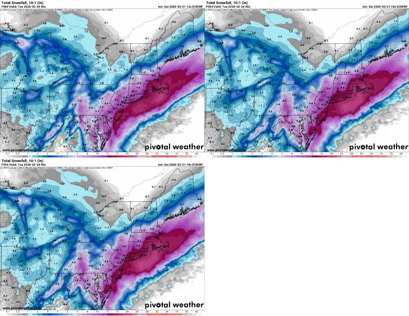
Euro mostly held serve. Weird QPF output. Slightly north of of 12z at hr 42
-
2/21 18z EURO AI AIFS: Total QPF 2/22 - 2/23-24 Snow 10:1
-

“Cory’s in NYC! Let’s HECS!” Feb. 22-24 Disco
Damage In Tolland replied to TheSnowman's topic in New England
Yup . There’s so much knee jerk reactions to qpf and never much analyzing deeper -
Who said this was good??? It’s trending the wrong way today. Looks like a classic Niña screw job now.
-
I went back earlier to page 29 & 30 just for shits and giggles
-
It does get to crazy in here... If folks think the modeling will stay stable run to run with the incredible multi-level dynamics in play, they are dreaming. So the max snow zone shifts around a bit from run to run? Has the big picture canvas changed? Are the jet fields and orientation significantly different? No, no and no! Has the inflow potential changed to suggest lower qpf? Has the potential for big meso banding features disappeared? Has the unstable look to the sounds changed? Again, no, no and no. Does that mean everyone gets a perfectly forecasted huge totals... No, because it rarely does. Go study some of the snowfall totals from Kocin storms, including Feb 78... There is more varibility than most want to admit. So relax and enjoy the storm whether you get 5" or 25"... I see nothing uniquely different with this setup compared to other true biggies. If it doesn't work out for your particular location, it's just the reality of a very complex atmosphere, not because of bad modeling.
-

2/22-23 "There's no way..." Storm Part 2
Scarlet Pimpernel replied to Maestrobjwa's topic in Mid Atlantic
Ahhh, thank you very much sir! That makes sense. Again, I do like the cluster of western solutions in there. -
As someone I know said after visiting Home Depot today, "It's as if we're in spring. you'd have no idea there was a storm coming" because they have absolutely nothing left.
-
“Cory’s in NYC! Let’s HECS!” Feb. 22-24 Disco
ChangeofSeasonsWX replied to TheSnowman's topic in New England
I've always said that at some point in my life I would like to see something IMBY that rivals 1978. I certainly don't expect every biggie to reach those numbers but someday it would be fun to experience that. For the Cape 2005 was bigger than 1978 and for CT I guess it would be Nemo or 1888. 1978 is still the benchmark in the PVD area and while I know that this one wont surpass it, maybe it would come close if these top tier solutions verified. -
Feels like we’re finally working toward a consensus
-
2/22-23 "There's no way..." Storm Part 2
SomeguyfromTakomaPark replied to Maestrobjwa's topic in Mid Atlantic
It’s pretty tucked here, great looking panel at 0z Monday.


.thumb.png.2be92fcdefb05a6fd2801186a8353423.png)


