All Activity
- Past hour
-
It's official now Caps fans... Last rodeo for Ovie https://www.prohockeyrumors.com/2026/10/alex-ovechkin-to-retire-from-nhl-after-2026-27-season.html#ref=home
-
 https://dutashielddirect.com/# can i purchase generic avodart price
 -
Yep, utter bullshit again
-
Yeah new Euro data today is warmer and wet all 3 winter months
-
 And it did come in... 5.683m km², a 1.008m increase in the last two weeks Sent from my SM-S176V using Tapatalk
 -
We'll never know...take methuen for example ...the west side is colder than the east side. That is especially true closer to Pelham. It is not unusual for that part of the city to receive more snowfall especially in "mixed" storms..
-
I don’t know how WW does this for a living it took like 10 entire minutes to copy and paste the images
-
Without even looking, I'll assume it's a bit warmer and drier, and that ridge has continued to edge southward.
-

2026-2027 Record-breaking El Nino
GaWx replied to Stormchaserchuck1's topic in Weather Forecasting and Discussion
We’re almost certainly heading for the most E based Nino on record for good or for bad. The SE ridge should be held back bigly, which would be really good from my perspective. -
extended still looking mild/nino-ish
-
Yea, believe me, I don't trust precise measurements from back then....no argument at all. I get your point.
-
October 5 1963: A heat wave hits part of Minnesota with highs of 98 at Beardsley, 96 at Madison, and 94 at Elbow Lake. For Monday, October 5, 2026 1638 - The journal of John Winthrop recorded that a mighty tempest struck eastern New England. This second severe hurricane in three years blew down many trees in mile long tracks. (David Ludlum) 1786 - The famous "Pumpkin Flood" occurred on the Delaware and Susquehanna Rivers. Harrisburg PA reported a river stage of twenty-two feet. The heavy rains culminated a wet season. (David Ludlum) 1917 - The temperature at Sentinel, AZ, soared to 116 degrees to establish an October record for the nation. (The Weather Channel) 1972 - Heavy rains, mostly the remnants of Tropical Storm Joanne, fell across much of Arizona. It was believed to be the first time in Arizona weather history that a tropical storm entered the state with its circulation still intact. The center was over Flagstaff early on the 7th. (3rd-7th) (The Weather Channel) 1987 - It was another day of scorching heat for the southwestern U.S. Afternoon highs of 102 degrees in Downtown San Francisco, and 104 degrees at Monterrey, established all-time records. The high of 101 degrees at San Jose was a record for October. Sacramento tied their record for October for the third time in the month, with a reading of 102 degrees. The high for the nation was 111 degrees at San Luis Obispo and Palm Springs. Twenty cities in the southeastern U.S. reported record low temperatures for the date, including Knoxville TN with a reading of 34 degrees. (The National Weather Summary) 1988 - Thirteen cities in the central U.S. reported record low temperatures for the date, including Duluth MN with a reading of 21 degrees. Goodland KS reported an afternoon high of 39 degrees. Showers over Upper Michigan produced an inch of snow at Marquette. (The National Weather Summary) 1989 - Showers and thunderstorms associated with Tropical Storm Raymond deluged southeastern Arizona with heavy rain. Up to four and a half inches of rain was reported north of Wilcox. Three- fourths of the streets in the town of Wilcox were left under eighteen inches of water, and damage exceeded a million dollars. Evening thunderstorms developing along a cold front produced severe weather in Oklahoma and the Texas panhandle. Thunderstorms produced high winds which gusted to 80 mph at White Deer TX, and resulted in one death at Pocasset OK. Thunderstorms produced golf ball size hail at Pampa TX and Lefors TX. (Storm Data) (The National Weather Summary) Observances: 5 Mon Child Health Day 5 Mon National Get Funky Day 5 Mon National Do Something Nice Day 5 Mon World Habitat Day 5 Mon World Architecture Day 5 Mon World Teachers’ Day 5 Mon National Above the Bus Day 5 Mon National Apple Betty Day 5 Mon National Be Nice Day 5 Mon National Kiss a Wrestler Day 5 Mon National Military Podcast Day 5 Mon National Rhode Island Day 5 Mon World Meningitis Day
-

2026-2027 Record-breaking El Nino
OSUmetstud replied to Stormchaserchuck1's topic in Weather Forecasting and Discussion
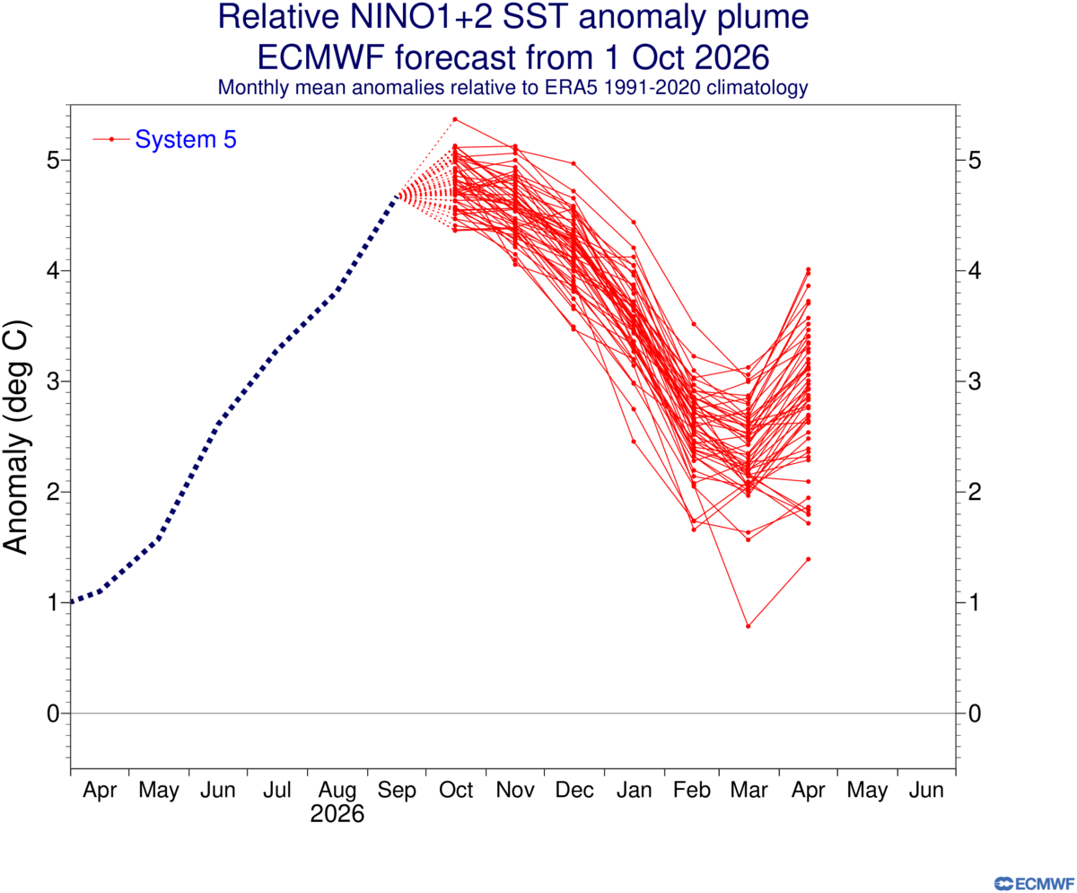
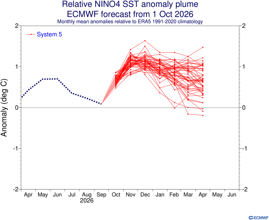
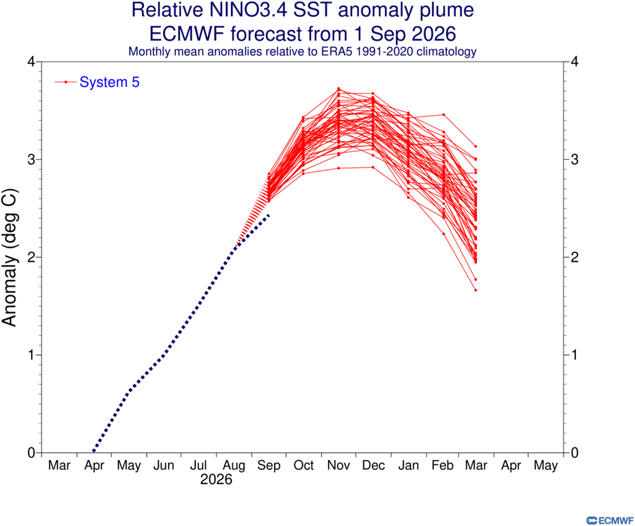
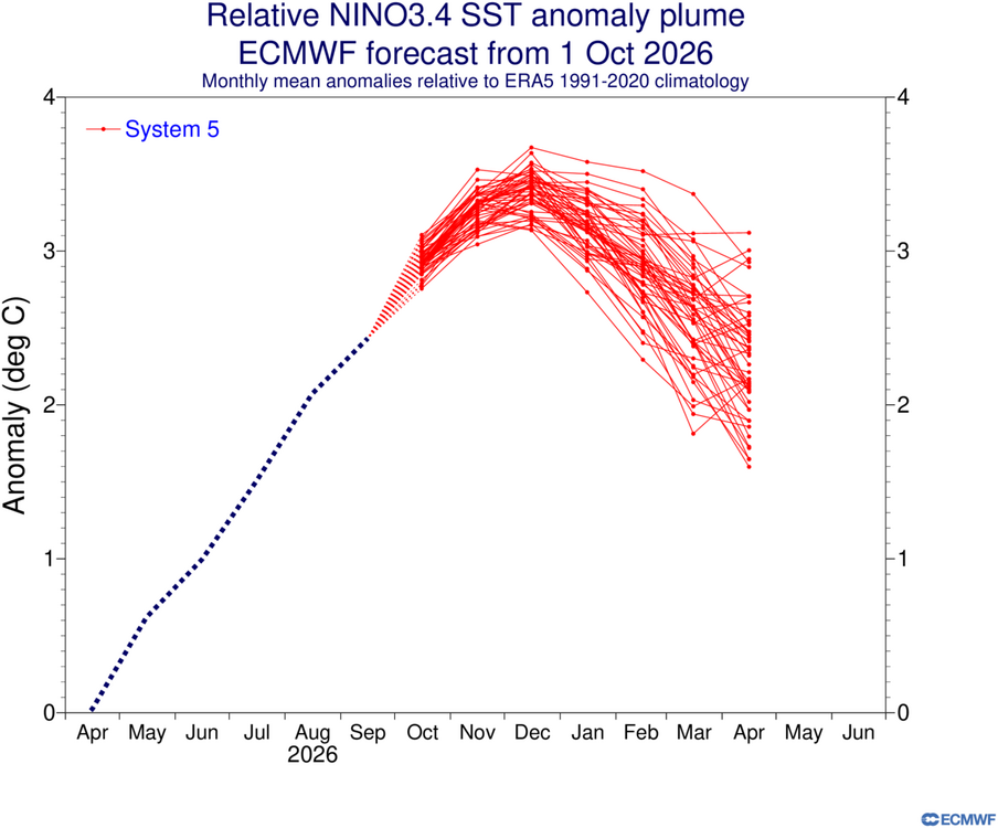
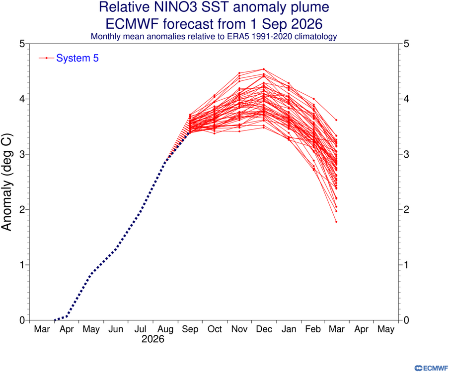
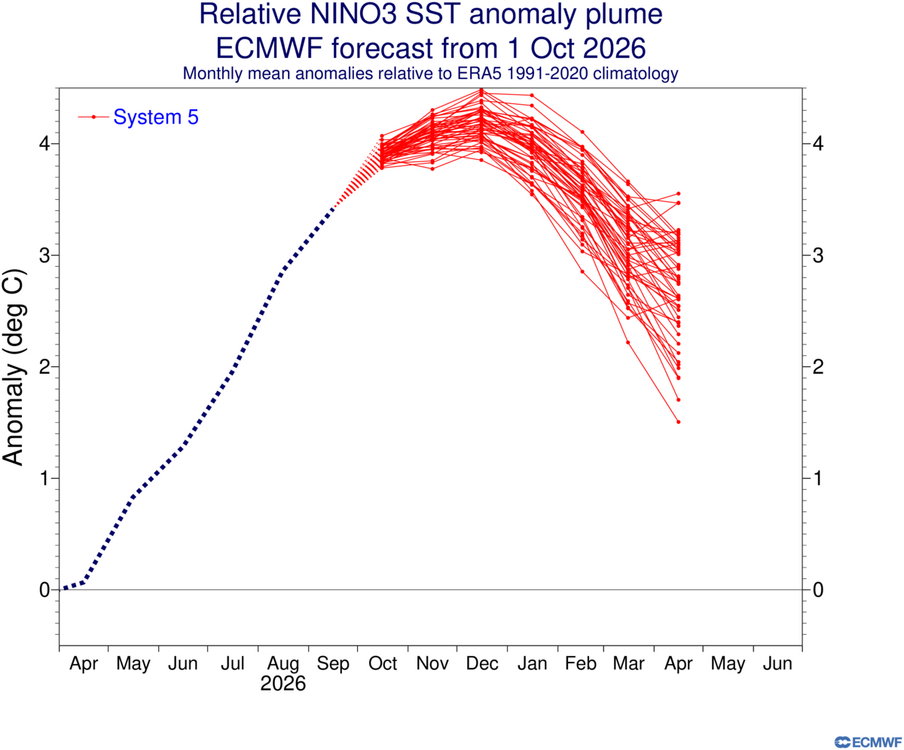
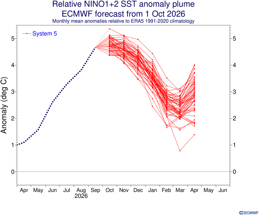
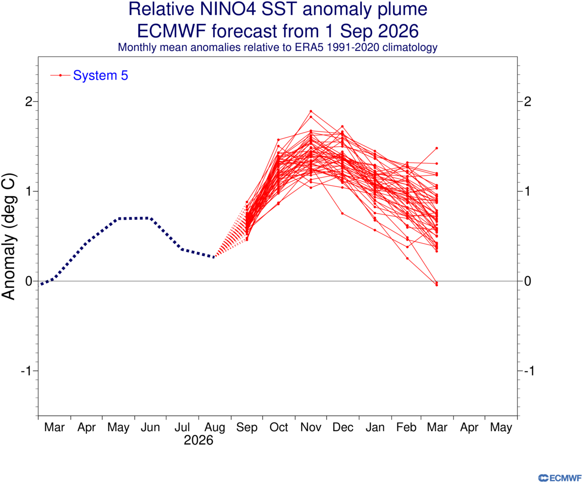
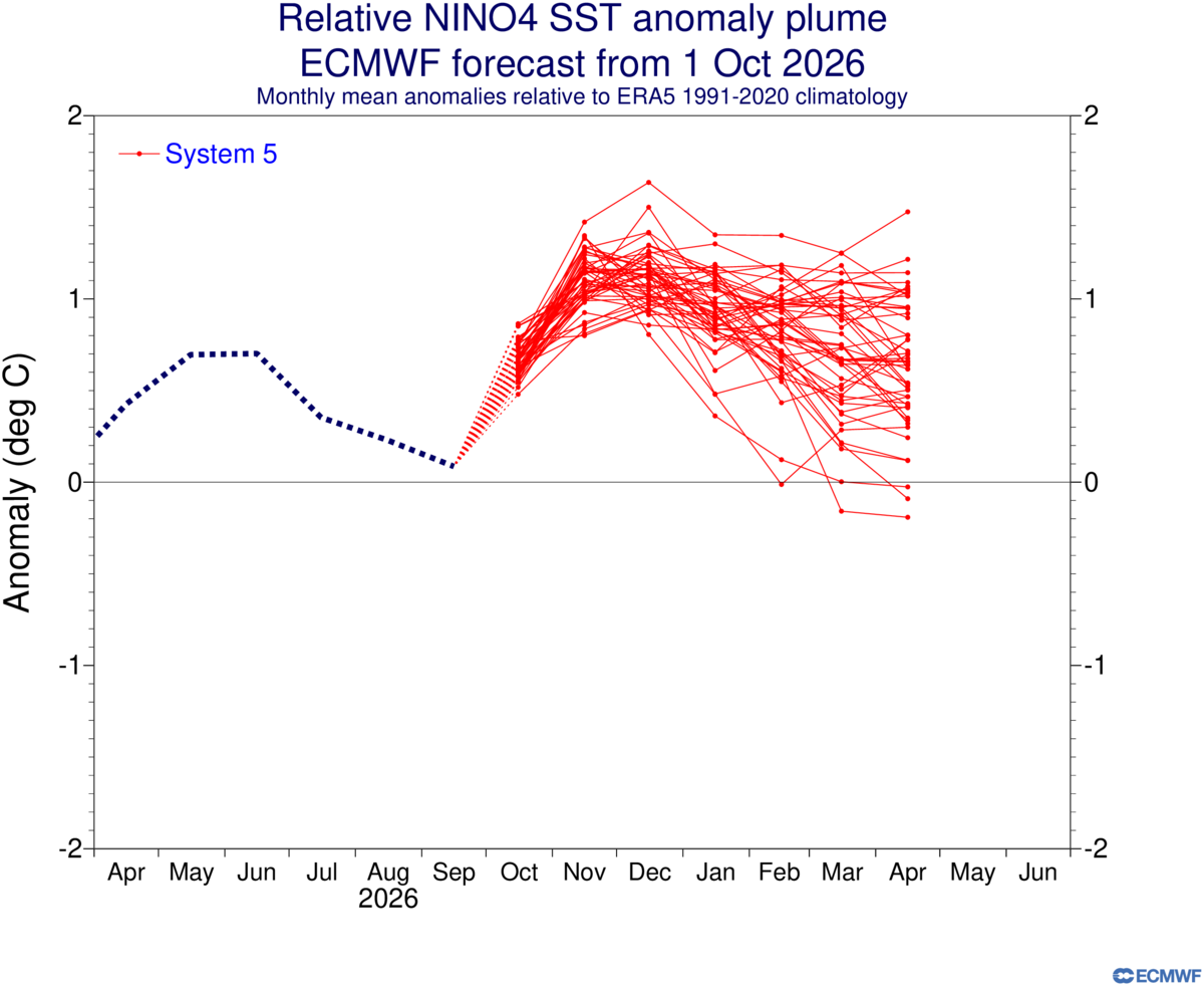
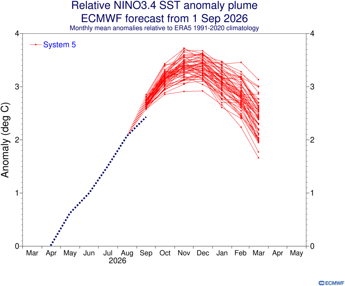
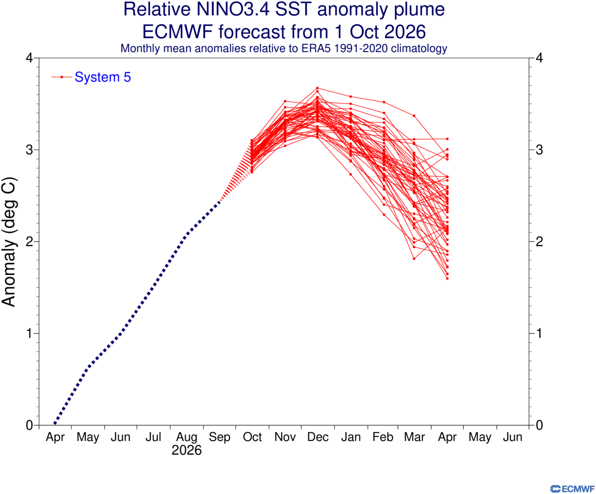
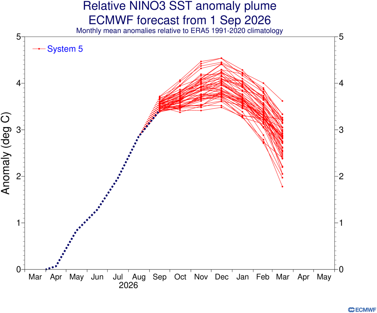
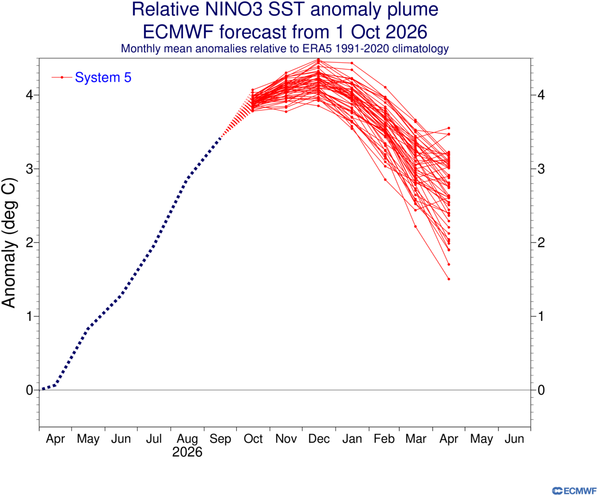
ECMWF October Nino plumes adjusted upward in Nino 1&2 and Nino 3, stayed consistent from the previous month in Nino 3.4, and lowered the forecast for Nino 4.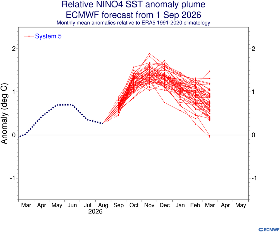
.thumb.png.4f3855d3cea14898d7f473a8138e8b2a.png)
-

2026-2027 Record-breaking El Nino
mitchnick replied to Stormchaserchuck1's topic in Weather Forecasting and Discussion
Monthly temp and precip care of bncho in MA forum. -
 Given that this might be a late season sprawling system, definitely a good chance this is a moisture laden system. Resharing here.
- 1 reply
-
- 3
-

-
2026-2027 Fall/Winter Mountain Thread
strongwxnc replied to BlueRidgeFolklore's topic in Southeastern States
It was a brutal smack in the face for sure. -
If you go back into the 1600's -1800's it was not uncommon for measurements to be taken until a day or 2 after a storm had ended... often times people didn't venture outside until they felt safe to do so...they had no real way of knowing if a storm had ended or not....it was risky to venture from home because the concern was being caught out in the elements with no way of summoning help.
-
2026 Atlantic Hurricane Season
WxWatcher007 replied to Stormchaserchuck1's topic in Tropical Headquarters
Thread up now. -
cost avodart: DutaShield Direct - where buy cheap avodart for sale
- Today
-

2026-2027 Fall/Winter Mountain Thread
Met1985 replied to BlueRidgeFolklore's topic in Southeastern States
The models absolutely crapped the bed with the past weekend rain event. -
2026-2027 Record-breaking El Nino
GaWx replied to Stormchaserchuck1's topic in Weather Forecasting and Discussion
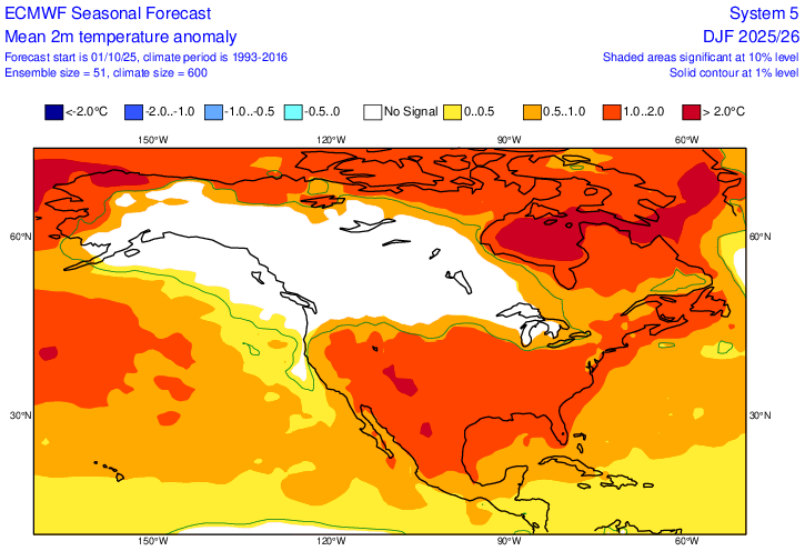
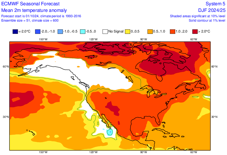
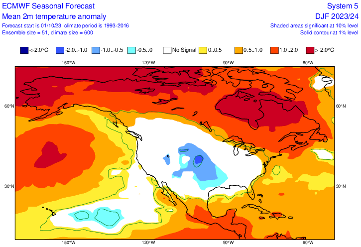
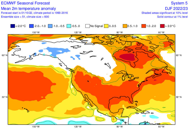
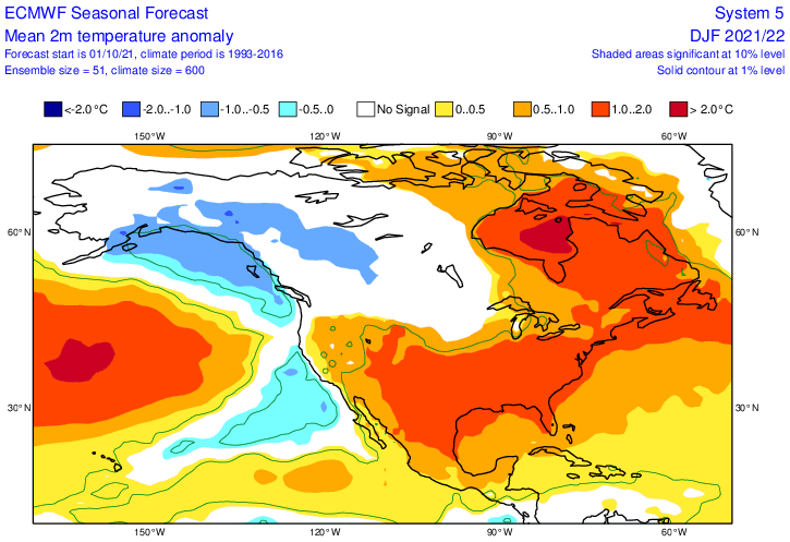
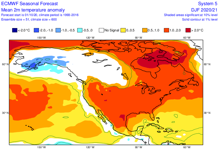
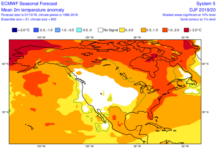
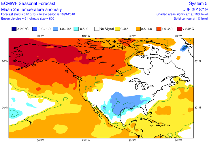
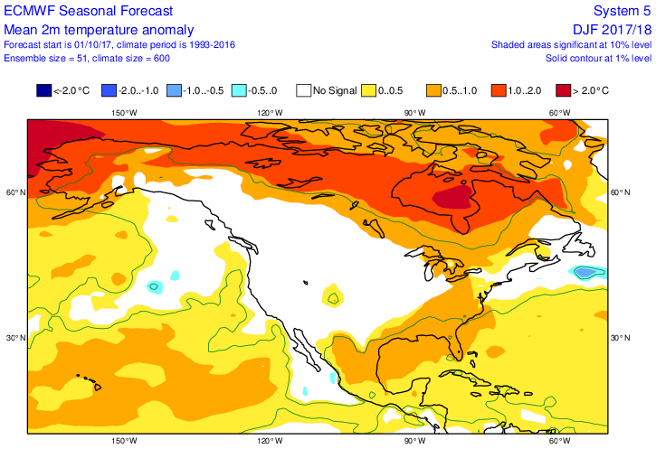
Thanks, Mitch. Here are the Euro Oct progs for winter going back to 2017-8 for comparison purposes and how they did in the E US: 2026: 2025: much too warm 2024: much too warm 2023 (Nino): too cold 2022: too cold (not warm enough) 2021: net slightly too warm (close SE, too warm NE) 2020: net too warm (much too warm SE; avg of too warm NE but close N Eng) 2019: pretty close (slightly too cold SE but close NE) 2018 (Nino): net too cold (close NE but much too cold SE): 2017: close ———————— Tally: -did well in 19 and esp. 17 -did pretty well 21 -did pretty badly 23, 22, 20, 18 -did terribly 25, 24 -too cold both El Niños in SE and 1 of 2 in NE -NE: too warm on 4, close on 3, too cold on 2 -SE: too warm on 3, close on 2, too cold on 4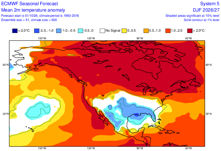
-
Incredible cold blast. Minus 2 at Tallahassee, 2nd coldest week at Central Park (though well behind 12/29/17-1/4/18) and the NJ snow paradox - the state's least snowy spot gets 34", biggest snowfall in NJ records.
-
Right....but, that was Boris' whole point, to whom you replied. I merely made the distinction....not assigning any blame at all.
-
Yeah, weren't there supposed to be highs in the upper fifties and low sixties this week?
-
It has been quite the torched fall...lol









.png.8a20e4ebb64e8df54c3a2db172869d41.png)