All Activity
- Past hour
-
-
 Moon visible now with flurries ending. Final core is 2.0”/0.05”….so that’s 6.3”/0.16” since I snowblowed this morning. Event total 15.5”/1.01”
 -

The “I bring the mojo” Jan 30-Feb 1 potential winter storm
Coach McGuirk replied to lilj4425's topic in Southeastern States
Potential coastal low this weekend. It will be cold enough. -
10-14” on their 730am report. I’m convinced that if you add up the lower number of Jay’s range you’d get their actual annual snowfall.
-
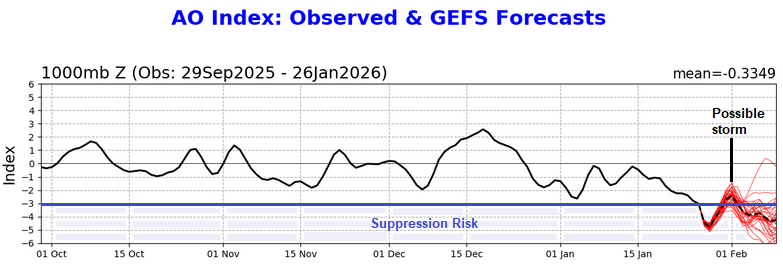
Based on the forecast teleconnections, a track that leads to impacts in the northern Mid-Atlantic/southern New England regions remains plausible. The PNA+ promotes an eastern trough and the AO- block can slow the system. With the AO rising rapidly, but remaining strongly negative, the risk of suppression is reduced over what it would be were the AO to be at or below -3.000 and falling. An out-to-sea or only grazing solution remains possible, but solution that has at least some impacts remains more likely than a purely out-to-sea solution. IMO, the 1/26 18z ECMWF-AIFS provides a plausible outcome. It also has support from the NBM's probabilities. Currently the storm and its development remain beyond the range of the models' capability to skillfully resolve the synoptic details that will lead up to the possible event. Until then, the broader longwave pattern and its evolution offer insight. At this lead time, storm formation seems to be a reasonable scenario. A coastal or out-to-sea track are both realistic possibilities with the former still looking more likely than the latter. By Wednesday or perhaps Thursday, there should be greater consensus on the outcome, especially as the guidance will be starting to resolve the all-important synoptic details. For now, a moderate- or high-impact storm remains on the table.
-

Snow Contest January 25th-26th
Roger Smith replied to WeatherGeek2025's topic in New York City Metro
If we're going pro, I am going to be Don's caddy. -
Well, you were absolutely right to be gun shy with respect to that type of forecast – how often do we actually get upslope-style snowfall ratios with surface temperatures around 0 F? I will say that thankfully, temperatures did come up quite a bit today – we got up to 15 F in the valley, which felt really nice. While that may not seem all that warm, without any wind it’s dramatically different from temperatures below zero F with brisk winds. Anyway, we certainly doubted whether or not Mother Nature could pull off those higher snow totals in the forecast at those temperatures, but she did. We just hit 20” on the storm as tonight’s snow is rolling through, and low and behold, we are just about to hit 0.75” of total liquid equivalent. So, it was just like the upper end our ~10”-20” point forecast range here suggested, and the overall snow to liquid ratio is around 27:1 for the storm. Kudos to the BTV NWS for their forecasting as usual. And for folks that got our for powder turns today, if you were wondering why the quality of the powder seemed like it was off the charts good… well, you weren’t crazy. The quality of the powder was off the charts. OK, well maybe it wasn’t quite off the charts, since I can, actually, chart out just why the powder skiing was of such incredible quality around here. As noted earlier in the discussion, the storm started off Sunday afternoon with a couple inches of 11.1% H2O/ 9:1 snow, then during Sunday evening, the snow to liquid ratio more than doubled, for another 7 to 8 inches of 4.2% H2O/24:1 snow. Then overnight, the ratio nearly doubled again, leaving about a half foot of 2.4% H2O/42:1 snow. Then through the day today there was another half foot of snow that fell in the 1-3% H2O range. Even for around here, that’s some impressively dry powder, and with the way that right-side-up density gradient came together, it skied really well. This certainly wasn’t an especially large storm by Northern Greens standards, but the very high quality of the powder that fell was definitely noticeable.
-
2016 redux.
-
I love that we just finished a storm yesterday and the next opportunity is close enough that we’ve got NAM analysis on it.
-
Looks like a really weak clipper that barely makes it over the mountains. Other models have it, but almost none of them have any appreciable precip on the lee side of the mountains.
-

January 2026 Medium/Long Range Discussion
WeatherGeek2025 replied to snowfan's topic in Mid Atlantic
-
The storm isn't necessarily in NAM range, but all the features that will tell us whether it goes OTS or up the coast will be in place by then, like you said.
-
Snow Contest January 25th-26th
WeatherGeek2025 replied to WeatherGeek2025's topic in New York City Metro
i think your location should be discarded that was mostly just for fun but the major cities i think is cool. And maybe we can throw in a reward for winning like a small crypto reward or something i'm interested in chipping in as a tournament fee if you will. We could always continue these into rain events and wind events and heat days and so on -
 20.2" as of 7PM - next update should be Midnight Only needs +1.3" for this to be the #10 snowstorm in Boston history, don't think that should be a problem given the surrounding reports from other board members. Very easy for folks to lose perspective with just how lucky we've been in the recent past. While its come at a cost (warmer winters), if this one scratches out 21.5", 5 of the top 10 storms all-time for Boston will have come since 2013.
 -
Yeah, nam dropping Friday morning rush hour snow
-

Texas 2026 Discussion/Observations
Stx_Thunder replied to Stx_Thunder's topic in Central/Western States
Additional ice & sleet damage reports in NTX/NETX, and SETX (including Houston metro area), finally came in from DFW and Houston NWS offices. The highest (reported) Freezing rain total in ETX was 0.75", in Panola county. The highest NTX Sleet storm total was 5.5" in Celina, or Collin county. -
 think logan was at 20.2 but that's a few hours ago
 -
It’s wild that just started tracking a hecs and are in Nam range already lol What’s this snowstorm Nam is giving us Friday?
-
I do kind of like the look of the NAM at range
-
Snow Contest January 25th-26th
Roger Smith replied to WeatherGeek2025's topic in New York City Metro
Okay, I can post the numbers from climate summaries (the last one we need shows up soon after midnight). It will be the total snowfall for 25th-26th as shown in climate summaries and where possible on CF6 forms too. Your scoring system is basically total of absolute errors, should probably be to decimal places as results and some forecasts have a decimal involved. But whatever it will work out the same probably. As to the forecasts for "your location" some of those would involve taking a forum report, a few can be verified the same way as above. But likely you wouldn't include them in scoring, right? -
anybody know the total for Boston?
-
gotta say I didn't have stars out and still flakes flying 40 hours after it started, unbelievable deep winter feel out there, like it should be.
-
Yep-I remember how much ice I saw on Reynolds Channel in Jan 2004 and being amazed, it really resembled the Arctic. Would be awesome to see that again.