All Activity
- Past hour
-

2026-2027 Strong/Super El Nino
michsnowfreak replied to Stormchaserchuck1's topic in Weather Forecasting and Discussion
This is a good point. But even then, its not steady temps across the board. Its still colder in the mean in the north than the south. Which means blues in the south arent necessarily great for snow, but reds in the north arent prohibitive of snow either. -
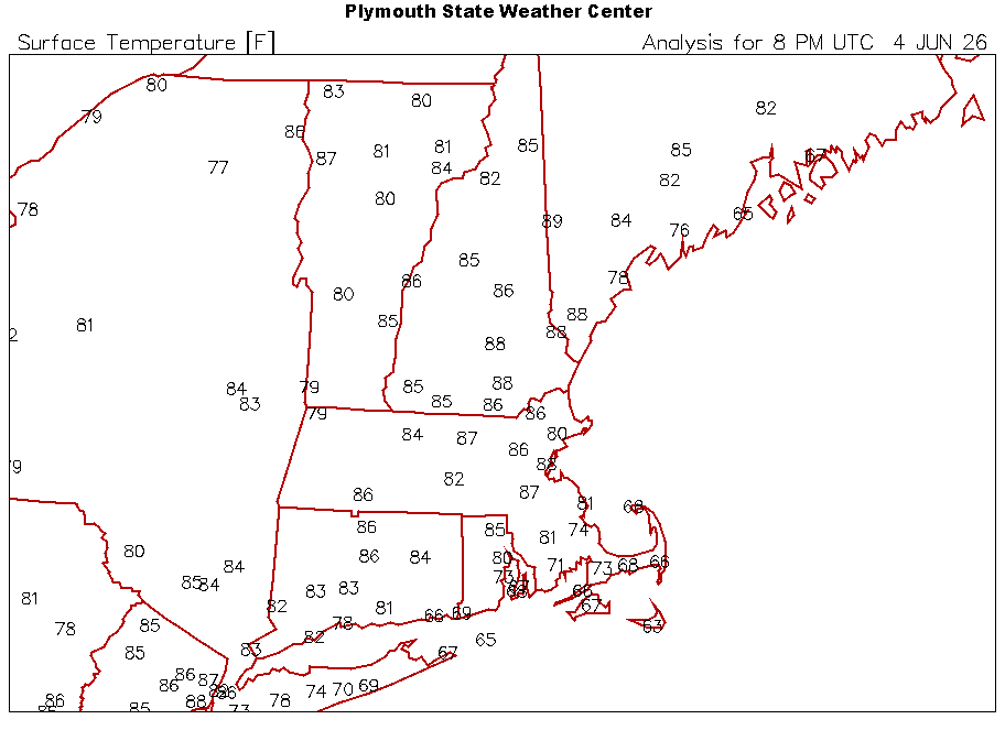
SW 13kt and back down to 86°. Maybe a pilot had the over on 88°
-
2026-2027 Strong/Super El Nino
michsnowfreak replied to Stormchaserchuck1's topic in Weather Forecasting and Discussion
Going to be a snowy winter in Vegas and Miami! -
2026-2027 Strong/Super El Nino
michsnowfreak replied to Stormchaserchuck1's topic in Weather Forecasting and Discussion
Same with Erie. And NYC for that matter. 1990s winters were warmer than 2000s or 2010s winters. The globe may have warmed in that timeframe but winters in the Lakes/Northeast were colder the next 2 decades after the 1990s. So any parallels to the 1997-98 nino I certainly wont be worried about a verbatim weather scenario with temps a degree or 2 warmer, thats not how the weather works. -
BOS is always a gamble to bet on. There was a wind error in there around the time the wind flipped though. I don’t think they gusted to 51kt. lol
-
Sun could be interesting. Ydy it acted more like a BDF and cool marine infested, but tdy not at all. BDF in a classic sense occurs when it is anticyclonic NW flow here w/ high heights/thickness, and the only cool air is very shallow. Not the case here at all. It is cyclonic flow aloft w/ falling heights and a decent vort/shortwave moving in Sun aftn. GFS/ECM show half-decent CAPE and w/ the cold 500 temps and dynamic support, could be good in some areas. Not honkin' svr, but I bet good enough for WxWiz! The front sagging just to S may actually help in this case. Also, cells dropping N to S? They tend to do well.
-
Which ensembles have 90’s next week?
-
+6 degrees within 5 minutes. Definitely didn't expect that. The first few observations looked suspicious too. Good call, @CoastalWx I guess I gotta' torch the sensor to collect on the over
-
Yes, and ASOS is as well. Recall it was noted that whatever falls in the ASOS gauge and melts as LEQ, can't be adjusted? So the 37.9" at PVD in the Feb storm had only 1.78" LEQ. That seems high the 21:1 ratio. BOS is much worse. 17.1" and only .47" LEQ for that storm? PVD -5", ORH -3.5", BDL -2.5" CON -2". So the -7.5" at BOS does not fit. And we are talking the first 5 months of the year where you do not have higher local differences from convection. But the media doesn't care, they just take thing as face value and run w/ it.
-
He certainly does...we all do
-
Yeah they flipped hard... SW gusting to 22
-
Warm one, but it is June
-

2026 Atlantic Hurricane Season
WxWatcher007 replied to Stormchaserchuck1's topic in Tropical Headquarters
Development signals continue on guidance today. -
BOS 88
-
Drying out fast here.
-
the N is actually calm - they're fighting though. Temp bounced to 88 which is on par with downtown anyway, but they back to SE at 7 ...altho I doubt they gusted to 59 unless they picked up some jet wash. ha! flip floppin
-
Winds out of the north now. Probably no good for highs staying below 88.
-
They are always low on everything. That gauge is Sus.
-
Dewpoints are in the low-mid 40s. To me upper 80s doesn't feel too bad with the very low humidity. It sucks that there's very little rain in sight though. I'll have to keep watering the vegetable garden almost every day.
-
Yeah...wore a "Diary of a Madman" T-shirt on relaxed dressed day which wasn't well received. Iron Maiden was just bursting onto the scene as well with Eddie T-shirts/Concert shirts which again the nuns frowned upon...


-
 All these forecasts showing large precip anomalies over us, I'm just not seeing it. Why are they such shitty forecasts? Are they hamstrung by having the follow model guidance?
 -
Winds are getting weaker and the temp is starting to increase. The timing was modeled pretty well by the HRRR, but the magnitude is likely off by a few degrees since a) HRRR==WRF (pretty observable negative bias) and b) HRRR has KBOS entirely over water. I just need the temp to stay below 88 and I do well Give me another hour of dat' muted sea-breeze, and I'll feel more confident.
-
Lets get some sort of show tonight
-

2026-2027 Strong/Super El Nino
Stormchaserchuck1 replied to Stormchaserchuck1's topic in Weather Forecasting and Discussion
May be one of the stronger -PNA's on record in the long range, near the 19-20th -
2026-2027 Strong/Super El Nino
Stormchaserchuck1 replied to Stormchaserchuck1's topic in Weather Forecasting and Discussion
Can someone say +AO? (For the 3rd warm season in a row, since the Solar Max)


.thumb.gif.f92b16c631a1d15d405ed77b33f0710d.gif)


