All Activity
- Past hour
-

“Cory’s in NYC! Let’s HECS!” Feb. 22-24 Disco
WxWatcher007 replied to TheSnowman's topic in New England
Heading back tomorrow morning after getting smoked up here yesterday. Perfect timing. Keep the shadowing to my north pls I started out conservative but made it clear my final map was likely to come up. Euro has been playing catch up the whole time and is on a relative island. I could see blizzard conditions well inland (maybe not Litchfield County) regardless of what BOX does. -
 I will start this off with NYC 16.5 LGA 17.0 ISP 23.9 JFK 14.5 EWR 19.8
 -
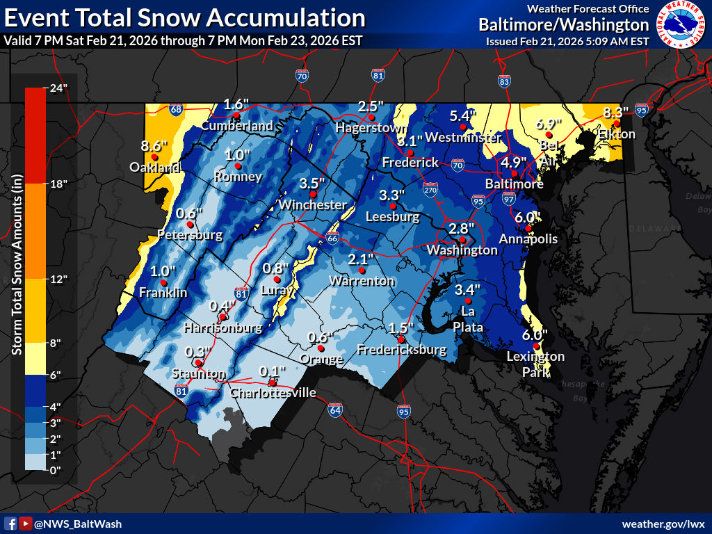
Hopefully the bleed E/NE ends today, but this has the feels of those storms that just keep slipping away. Latest LWX map below.

-
Truth
-
What I thought was blowing snow is also actual snow. Visibility across the river is about 3/4 mile. Maybe we'll score a little more than the 6" I had at 3:30.
-
Or beer
-

“Cory’s in NYC! Let’s HECS!” Feb. 22-24 Disco
CoastalWx replied to TheSnowman's topic in New England
They might Kev, but not sure whole area -
“Cory’s in NYC! Let’s HECS!” Feb. 22-24 Disco
CoastalWx replied to TheSnowman's topic in New England
Could care less what they have. -
my point and click for sayreville is 11-22 total.. Dani beckstrom on Channel 7 still had the 8-12 map up from last night...smh
-
Coming down good with OE along the back door front. Always nice to have coffee with the snow.
-

“Cory’s in NYC! Let’s HECS!” Feb. 22-24 Disco
mahk_webstah replied to TheSnowman's topic in New England
Similar up here. Every model has us with the dry air. It will suck for a bit, but there’s a lot of snow on the ground. And then you never know what could change today. -

“Cory’s in NYC! Let’s HECS!” Feb. 22-24 Disco
moneypitmike replied to TheSnowman's topic in New England
Out to shovel the 6". The wind's blown my deck clear--I can only imagine what Monday will be like on the coast. -
-

“Cory’s in NYC! Let’s HECS!” Feb. 22-24 Disco
Damage In Tolland replied to TheSnowman's topic in New England
In all honesty why wouldn’t that be for whole region with winds even inland gusting over 50? -
“Cory’s in NYC! Let’s HECS!” Feb. 22-24 Disco
moneypitmike replied to TheSnowman's topic in New England
Make it so! -
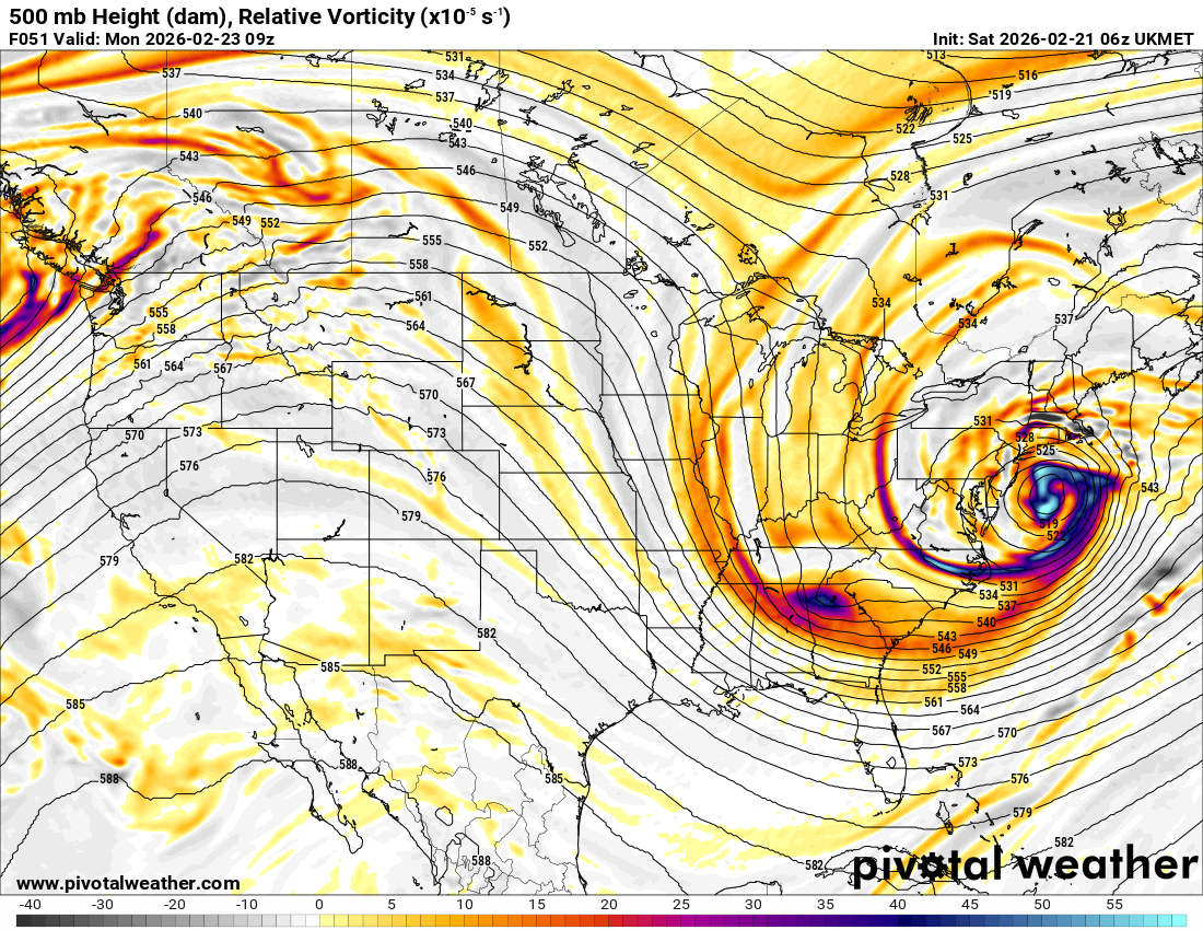
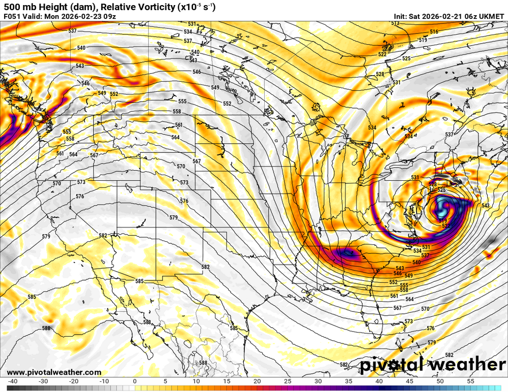
No love for the 6z UKIE?
-
“Cory’s in NYC! Let’s HECS!” Feb. 22-24 Disco
Damage In Tolland replied to TheSnowman's topic in New England
That would set the cape infrastructure back 30 years -
My second water load goes to Lucerne Dairy near Lansdale on Monday. Should get there around 1pm. I wonder how that's going to be if the crazy totals verify...
-

Central PA Winter 25/26 Discussion and Obs
canderson replied to MAG5035's topic in Upstate New York/Pennsylvania
Sticking with my 2-5” for MDT call from Tuesday, would be awesome if we get to 6-8”. If paved surfaces so not really get covered it lessens storms in my opinion and I tend not to care about 2” vs 8”. -

“Cory’s in NYC! Let’s HECS!” Feb. 22-24 Disco
The 4 Seasons replied to TheSnowman's topic in New England
BOX seems the office conservative with this one and OKX seems to be the aggressors, based on the maps theyve put out, timing and now warnings, BOX still holding off. -

“Cory’s in NYC! Let’s HECS!” Feb. 22-24 Disco
Snowcrazed71 replied to TheSnowman's topic in New England
Yeah.. the NWS has us ( you ) with the WSW and is calling for 8-13 inches. There being conservative to say the least. Btw... I saw some of the nerves come out last night with some posts with the 00z runs. Of course everything's looking fine this morning. I'm truly feeling it for this. -
“Cory’s in NYC! Let’s HECS!” Feb. 22-24 Disco
The 4 Seasons replied to TheSnowman's topic in New England
SREFs for a laugh..Elbow runner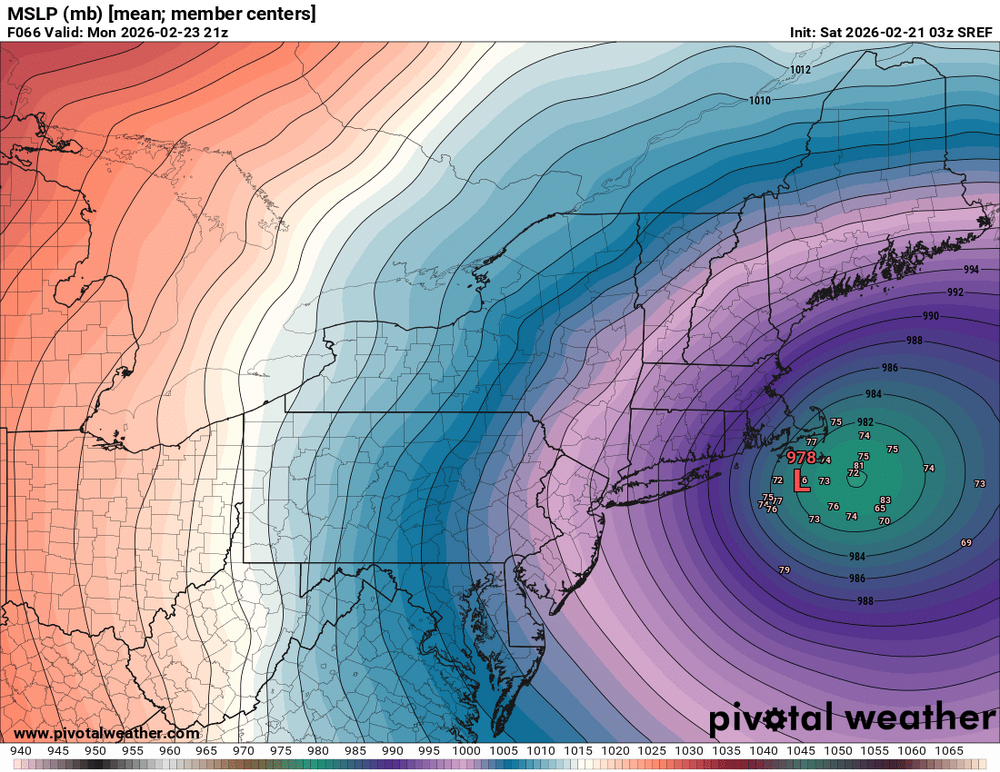
-

Central PA Winter 25/26 Discussion and Obs
Voyager replied to MAG5035's topic in Upstate New York/Pennsylvania
Not bragging, but showing. Here's mine... Sunday Snow, mainly after 7am. High near 33. Calm wind becoming east around 6 mph in the afternoon. Chance of precipitation is 100%. New snow accumulation of 2 to 4 inches possible. Sunday Night Snow. The snow could be heavy at times. Low around 26. Northeast wind 5 to 8 mph becoming north after midnight. Winds could gust as high as 24 mph. Chance of precipitation is 100%. New snow accumulation of 3 to 7 inches possible. -

Central PA Winter 25/26 Discussion and Obs
pawatch replied to MAG5035's topic in Upstate New York/Pennsylvania
Mu is following the Euro. He either going to look smart or going to look pretty stupid. Hope things stay steady today. Volleyball all day Lewisburg watching my Granddaughter. 37 degrees this morning. Ice is starting to move out at Lock Haven. -
“Cory’s in NYC! Let’s HECS!” Feb. 22-24 Disco
CoastalWx replied to TheSnowman's topic in New England
Blizzard warnings for CT coast and NYC. Will be upgraded up the coast later today.