All Activity
- Past hour
-

November 2025 general discussions and probable topic derailings ...
CoastalWx replied to Typhoon Tip's topic in New England
Nope. 12z had nothing yesterday. -
0.14" overnight, 0.87" on the month. Continuing to be very dry.
-
 It had rains to the pike
 -

Central PA Fall Discussions and Obs
Blizzard of 93 replied to ChescoWx's topic in Upstate New York/Pennsylvania
I like seeing High pressure set up in southern Quebec to feed in the cold. -
November 2025 general discussions and probable topic derailings ...
CoastalWx replied to Typhoon Tip's topic in New England
Man let’s get these busts in winter. -
November 2025 general discussions and probable topic derailings ...
CoastalWx replied to Typhoon Tip's topic in New England
Gfs had nothing yesterday. AI ftw -
November 2025 general discussions and probable topic derailings ...
CoastalWx replied to Typhoon Tip's topic in New England
Mann Canada is cold on the guidance. Let the highs build down and the CJ‘s began after the first week of December. -
November 2025 general discussions and probable topic derailings ...
CoastalWx replied to Typhoon Tip's topic in New England
Actually, that was a nice coastal. We take that. -

2025-2026 ENSO
Stormchaserchuck1 replied to 40/70 Benchmark's topic in Weather Forecasting and Discussion
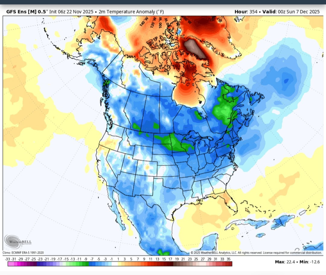
That's a major +NAO. The cold anomalies are from -EPO that happens days before. By the end of the run, it's neutralizing and more of a -PNA is trying to build. There is a few day lag between the evolving Pacific pattern and US Temps. It's pointing to an above average 2nd week of Dec. At 384hr you can already see the SE ridge trying to build. -
November 2025 general discussions and probable topic derailings ...
CoastalWx replied to Typhoon Tip's topic in New England
-

November 2025 general discussions and probable topic derailings ...
JakkelWx replied to Typhoon Tip's topic in New England
that is why i will move to new england when i get the chance -
.40" in the gauge this am, most in a 24 hour period this month and brings monthly total to 1.03". Quite warm for a late November morning, 56.5/55.6 with rain continuing to fall.
-
Yes and it’s congrats Ray north .
-
November 2025 general discussions and probable topic derailings ...
CoastalWx replied to Typhoon Tip's topic in New England
I didn’t see any change. Stop looking at twitter. Euro had a nice SWFE -
November 2025 general discussions and probable topic derailings ...
CoastalWx replied to Typhoon Tip's topic in New England
Where the eff did this come from? -
6z GEFS No western trough but a Great Lakes trough . You are overthinking this. Everything still looks fine going forward.

-
Rarely has anyone captured the pure excitement of our recent run of weather, so well and descript in written word.
-

2025-2026 ENSO
donsutherland1 replied to 40/70 Benchmark's topic in Weather Forecasting and Discussion
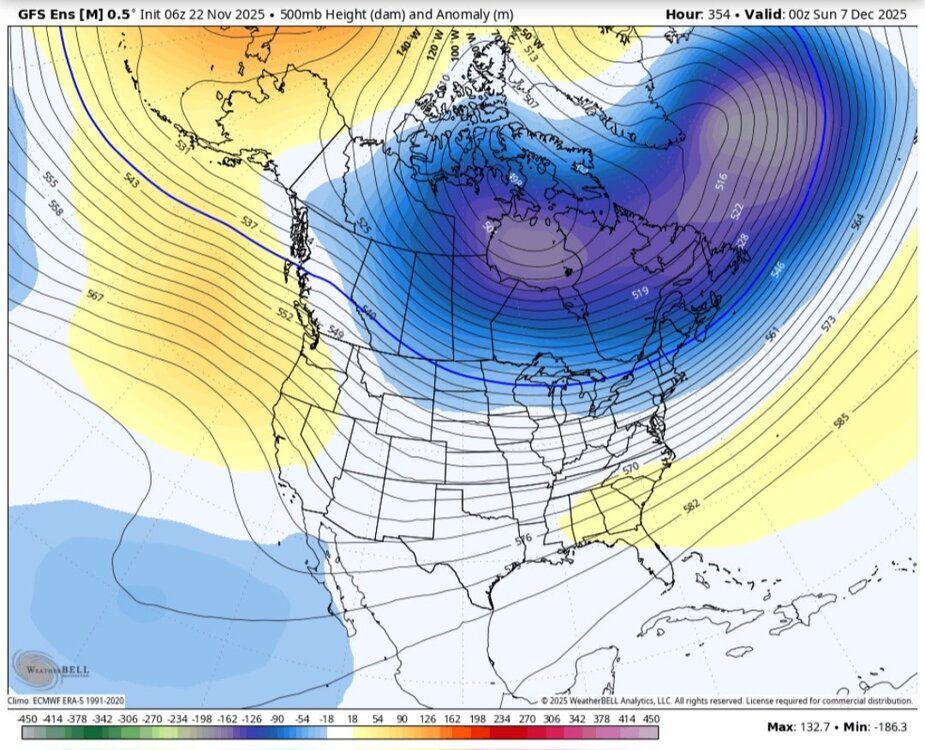
I wanted to illustrate that CPC isn’t panicking. This map at that timeframe is along the lines of what many of us are thinking. It’s very close to my baseline scenario. -

Central PA Fall Discussions and Obs
Jns2183 replied to ChescoWx's topic in Upstate New York/Pennsylvania
Ice Ice baby. Just like Decembers of lore Sent from my SM-G970U1 using Tapatalk -

November 2025 general discussions and probable topic derailings ...
kdxken replied to Typhoon Tip's topic in New England
Crummy day. -
My cousin and her fiancé were there last winter and he proposed to her under the northern lights! They said it was a truly amazing and unique place.
-

November 2025 general discussions and probable topic derailings ...
Modfan2 replied to Typhoon Tip's topic in New England
37F and rain, as November feel as you can get. .10” so far -
Central PA Fall Discussions and Obs
Blizzard of 93 replied to ChescoWx's topic in Upstate New York/Pennsylvania
The 0z Euro & GFS now show a chance out on December 4th. Hopefully that’s the beginning of the Winter tracking fun & games.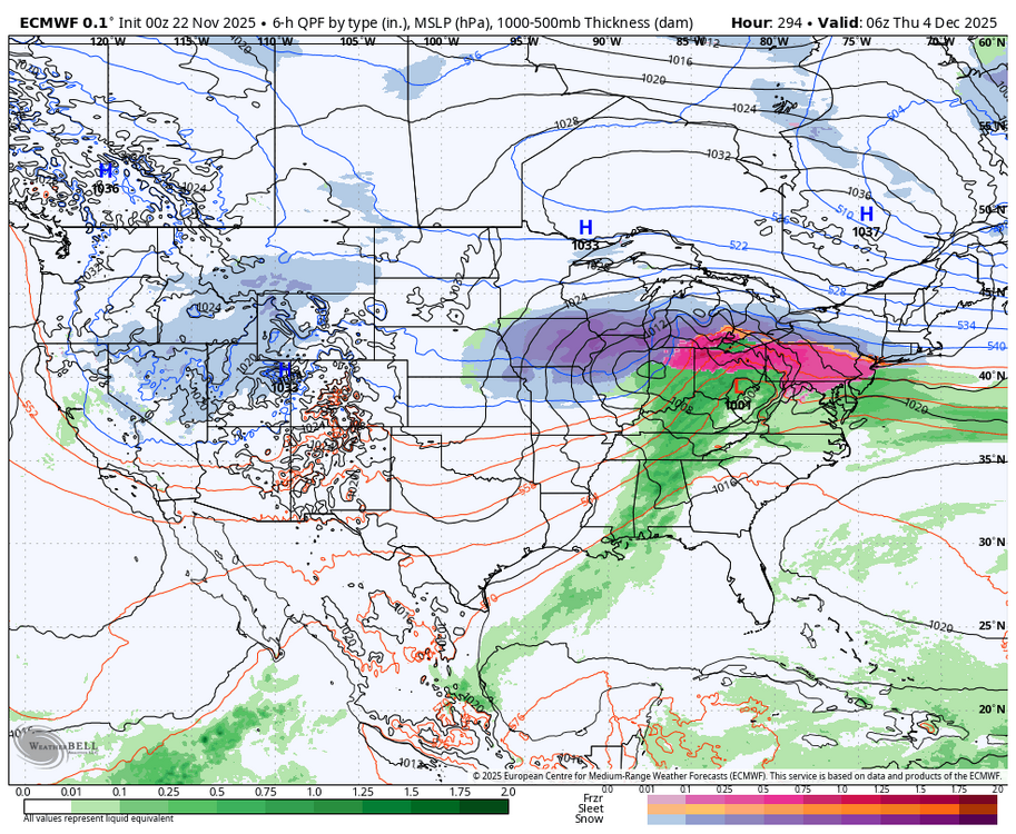

-
Not a great look into the first 5-10 days of Dec overnight