All Activity
- Past hour
-
This morning a pretty good plume of moisture has just been training over my area. In the last two hours, we’ve had 1.39in of rain! That’s the most in a day since the wet period we had in late July and very early August. It had gotten really dry here until this morning. Here’s hoping more areas can get in on it today. Radar looks pretty good for a lot of areas right now.
-
Its optimistic to expect a subpar winter? Or optimistic to assume its going to snow in Michigan as it does dozens of times every winter?
-
sorry for hijacking your optimism
-

Septorcher 2026 Discussion - Endless Summer
Damage In Tolland replied to Damage In Tolland's topic in New England
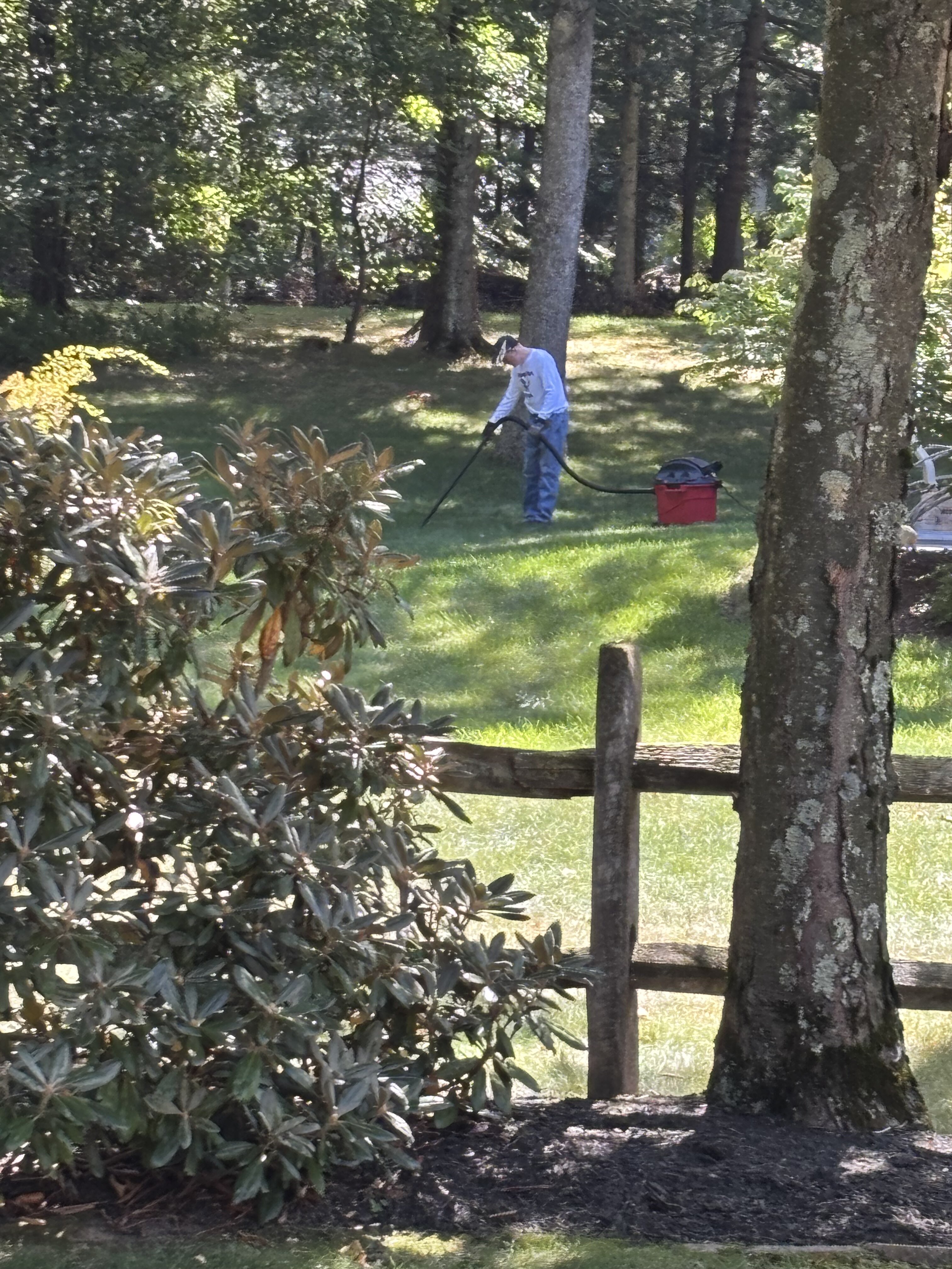
Next door neighbor shop vac’ing up acorns. Just when I thought I’d seen it all .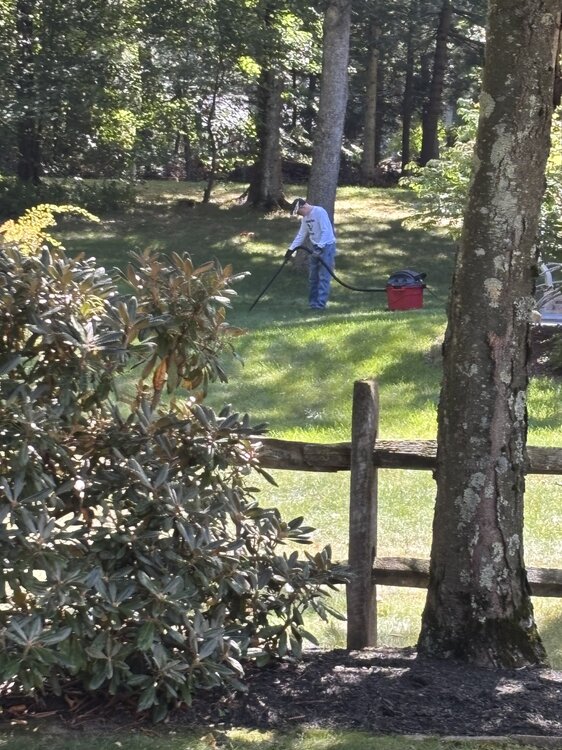
-
Septorcher 2026 Discussion - Endless Summer
Damage In Tolland replied to Damage In Tolland's topic in New England
Nam 3 k is ugly -
 canadian online pharmacy and top canadian pharmacy canadian pharmacy legit http://images.google.ae/url?q=https://northrxcanada.shop canadian pharmacy legitand http://www.1gmoli.com/home.php?mod=space&uid=1052779 my canadian pharmacy [url=https://www.google.com.co/url?sa=t&url=https://northrxcanada.shop]certified canadian pharmacy[/url] safe canadian pharmacyor [url=https://kamayegaindia.com/user/mdofjarcwa/?um_action=edit]reputable canadian online pharmacy[/url] pharmacies in canada that ship to the us
 - Today
-
Lmao. Actually the upper midwest is ground zero. But its all relative to normal. A Nino torch here is still solidly colder than your average and is usually because of 1 torch month. You can wish snow away all you want. It snows in MI no matter what. 2023-24: 34.9F 2015-16: 33.5F 1997-98: 33.9F 1982-83: 32.5F 1972-73: 27.8F 1877-78: 31.5F
-
An all time low for ONE month. Not a whole season.
-
The problem with trying to predict the winter season is there are a few other things to consider . One being the negative PDO - will it persist into the winter months ??? . Next is the Polar Vortex. - how will that behave ?. Another issue is the lack of melting in the Arctic region and Greenland this summer - 2 important cold air sources. Way too early to make any final winter forecasts.
-
each previous event makes the next one more likely to cause problems
-

Septorcher 2026 Discussion - Endless Summer
weatherwiz replied to Damage In Tolland's topic in New England
Should be a fairly widespread heavy rain tomorrow. Increasing LLJ across the region with a strong surge of higher theta-e air advecting in. Pretty well defined 700 warm front too moving across the region -
They've all been eliminated and we no longer speak of them. Snow is serious bidness.
-
(002).thumb.png.6e3d9d46bca5fe41aab7a74871dd8af8.png)
E PA/NJ/DE Autumn 2026 Obs/Discussion
ChescoWx replied to PhiEaglesfan712's topic in Philadelphia Region
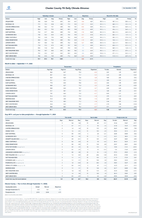
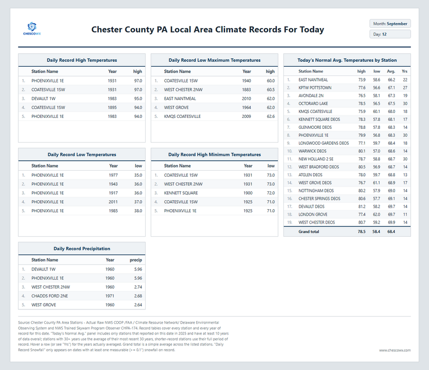
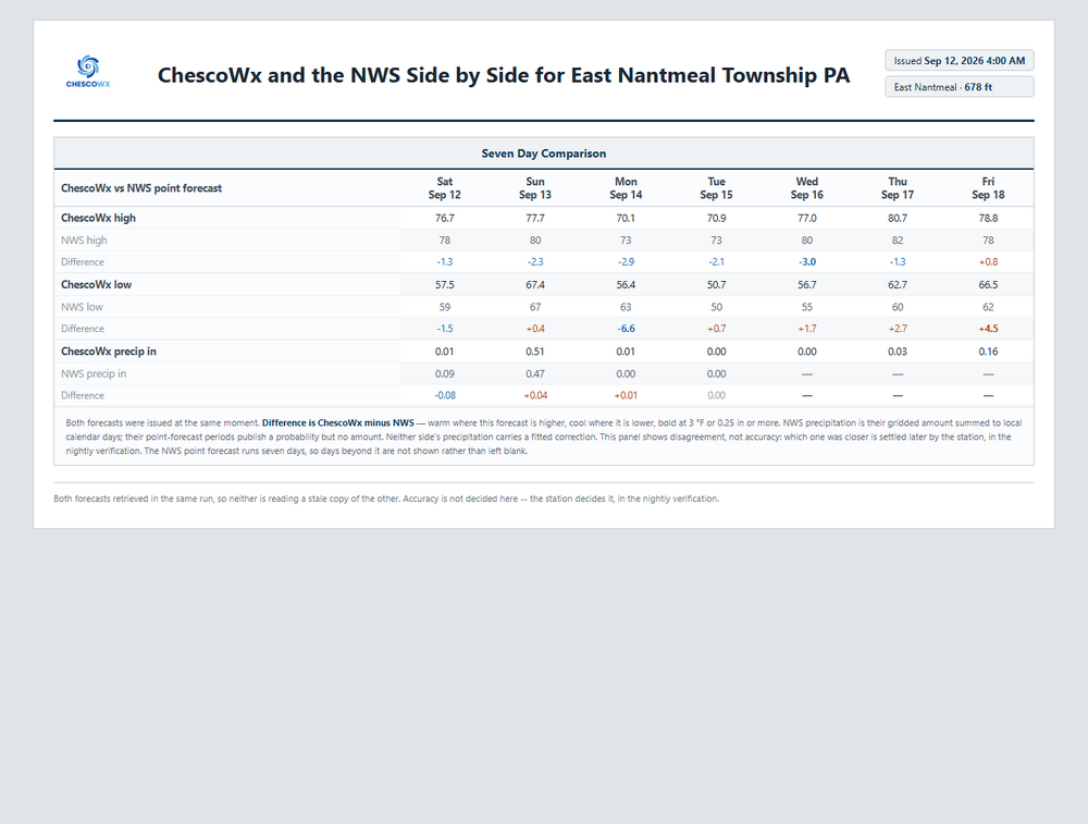
-
Who is doing that? Cite the name specifically?? All I see are expectations for a warm season with a heightened risk of a big snow event or two. Obviously the season could easily fail to produce like 1998, but it's not very compelling to discuss that in depth on a weather forum. The upside if we get lucky here in SNE is near normal snowfall and above normal snowfall in the mid atl.
-
It's a DJF mean. Worked for Feb 1983, but I agree it's precarious for the coast. Here is Feb....I think we have seasonable cold here with that ridging out west.
-

2026-2027 Record-breaking El Nino
40/70 Benchmark replied to Stormchaserchuck1's topic in Weather Forecasting and Discussion
https://psl.noaa.gov/enso/mei/ -
never forget that your area is ground zero for the flames of the nino torch
-
This ongoing and still strengthening El-Nino has allowed the 2026 tropical season (Pacific and Atlantic) to follow the Nino playbook to the letter and then some. If the coming Fall and Winter follow the Nino playbook as well as the tropical season has it is going to be a rough season for many in this sub forum. I'm taking an expect the worst and hope for the best approach. I think above normal precipitation and above normal temperatures (DJF) are pretty much a lock. We need to hope for a wet system to time itself with whatever cold air we can muster. Maybe we get a "big one" that way? Might be a big ask though. Maybe a more Modoki El-Nino can better save the day but think that is also a big ask. We'll see how we progress through Fall and go from there but keep expectations low. I suspect most sensible winter weather lovers are bracing for the reality that this Winter might suck.
-

Central PA Summer 2026 Discussion/Obs Thread
Superstorm replied to Voyager's topic in Upstate New York/Pennsylvania
Hate when that happens. . -
generic medicines in india and top online pharmacy in india prescriptions from india https://image.google.ps/url?q=https://indiagenericstore.com online medicine delivery now and http://asresin.cn/home.php?mod=space&uid=1216063 online medicine order [url=https://cse.google.co.ls/url?q=https://indiagenericstore.com]online generic medicine india[/url] indian pharmacy shipping to usa or [url=https://vintage-car.eu/user/wfjnwephje/]online medicine delivery in india[/url] buy meds online
-
canadian pharmacy service or canadian pharmacy store canadian pharmacy compare https://www.google.com.sv/url?q=https://northrxcanada.com my canadian pharmacy and https://brueckrachdorf.de/user/pzmzdxybyi/ canadian pharmacy comparison [url=http://whois.hostsir.com/?domain=http://northrxcanada.com]cipa canada online pharmacy[/url] top canadian pharmacy and [url=http://sotoycasal.com/user/hewpkmesxy/]pharmacies in canada that ship to the us[/url] certified canadian pharmacy
-
You had me at hello NWS Upton A southern stream shortwave passing over the area late tonight into Sunday morning with will tap into a tropical airmass (can see this plume of moisture on GOES-EAST Water Vapor over the southeast) with PWATs increasing to 2-2.3" by early Sunday morning. A warm front will also approach the area and potentially set up somewhere over the coast/Long Island on Sunday morning. A weak wave of low pressure may also track along the warm front. These ingredients will lead to showers with heavy downpours and a few thunderstorms late tonight into Sunday morning.
-
Yeah, not so sure one is needed for this upcoming event. Seems a bit over zealous. Then again we've had a lot of local over performers this season.
-

Central PA Summer 2026 Discussion/Obs Thread
canderson replied to Voyager's topic in Upstate New York/Pennsylvania
63 was my low. I really need rain - it is so so dry - so hope we get some good stuff overnight. -
It’s either that, or it’s showing above normal heights due to Pacific puke air. I’d rather the former.