All Activity
- Past hour
-

2025-2026 ENSO
so_whats_happening replied to 40/70 Benchmark's topic in Weather Forecasting and Discussion
It looks like the warm pool SW of the Aleutians may be on the move very similarly to how last year evolved. This should continue to push further east with time allowing the index for PDO to start to make a run to neutral status. If we do indeed start to push these waters further east toward the Gulf of Alaska it should allow for a weaker overall trough going into Canada then we have seen. The waters west of Japan into the Koreas and China is not dwindling any time soon but if the area further east does try to continue to cool it could play for a pretty impressive snow event or two as a giant lake effect event like they experienced a few years ago. https://psl.noaa.gov/map/clim/sst.anom.anim.week.html Also the MJO is finally on the move and actually becoming a wave versus the null action over the last 2 months. The enhanced trades are some of the furthest west we have seen in a long time this could very well continue to cool the waters at least around the eastern portion of the maritime continent as we go into late fall early winter. I would not be surprised to see one last system in the Caribbean for the month of October to close out the season as the MJO moves through 1-2-3.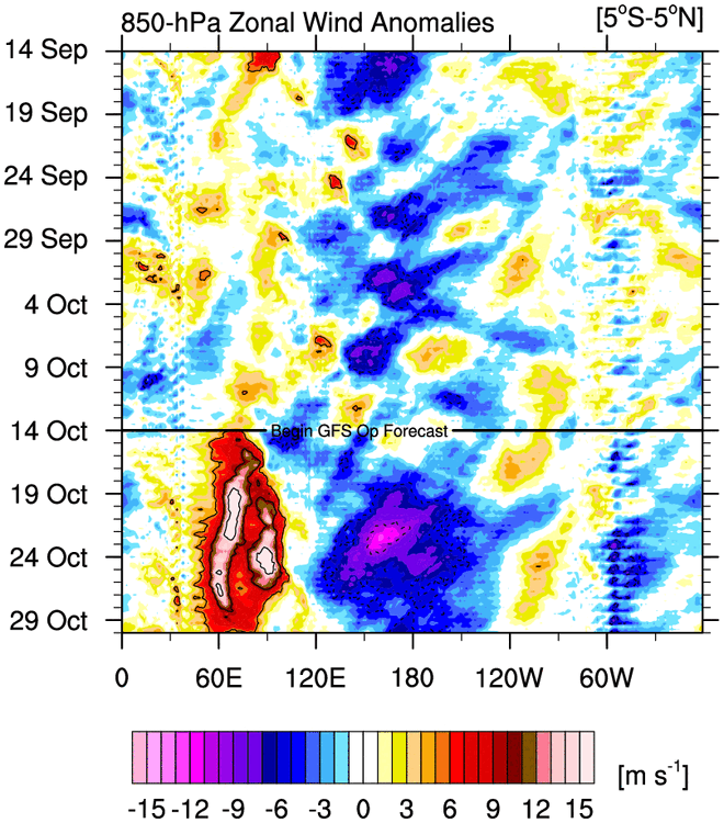
-
.thumb.jpg.6a4895b2a43f87359e4e7d04a6fa0d14.jpg)
Central PA Fall Discussions and Obs
Yardstickgozinya replied to ChescoWx's topic in Upstate New York/Pennsylvania
This video embraces the two things I miss dearly right now.Good winners and old times. The suspense is unbearable, but don't worry fellas Sally pulls through. -
Would be so crazy. Do think late October looks rather stormy regardless
-
This shit has to end eventually. But it feels like we’ve been saying that for a long time now.
-

Spooky Season (October Disco Thread)
CoastalWx replied to Prismshine Productions's topic in New England
Yeah all a what if game. I’m sure there would have been a mix to start for awhile as that high was just a bit east. -

Spooky Season (October Disco Thread)
Damage In Tolland replied to Prismshine Productions's topic in New England
Had snow OTG in 2011 but it was in low 40’s and melting . Have never had it snow on that day . For whatever reason that first 8-9 day period of Nov in very history almost always is mild . So it’s a very low chance. But if I look at progs this year.. can see how it’s not a zero chance . Normally it is -

The return of the elusive Nor'easter. Drought buster or bust?
Herb@MAWS replied to dailylurker's topic in Mid Atlantic
A whopping 0.28” for this non-event IMColumbiaBY. -

Spooky Season (October Disco Thread)
Torch Tiger replied to Prismshine Productions's topic in New England
novie snows used to be a thing -
Spooky Season (October Disco Thread)
Torch Tiger replied to Prismshine Productions's topic in New England
You'll see it. -
Spooky Season (October Disco Thread)
Damage In Tolland replied to Prismshine Productions's topic in New England
2nd -
Spooky Season (October Disco Thread)
Torch Tiger replied to Prismshine Productions's topic in New England
I saw snow on my b-day in 2009, random 10-15/16 snow. Only time I can recall -
Spooky Season (October Disco Thread)
Torch Tiger replied to Prismshine Productions's topic in New England
what day -

The return of the elusive Nor'easter. Drought buster or bust?
87storms replied to dailylurker's topic in Mid Atlantic
Terrible start, legendary finish. -
Spooky Season (October Disco Thread)
Damage In Tolland replied to Prismshine Productions's topic in New England
I think this year for the first time in 25+ years offers at least a low chance of snow on or near my bday . The pattern of aligned right shows the opportunity.It’s been an elusive chase for 52 years. Time is running out.. -

Spooky Season (October Disco Thread)
MJO812 replied to Prismshine Productions's topic in New England

-
DT called this ^
-
Luckily this is hour a million so it probably won't happen
-
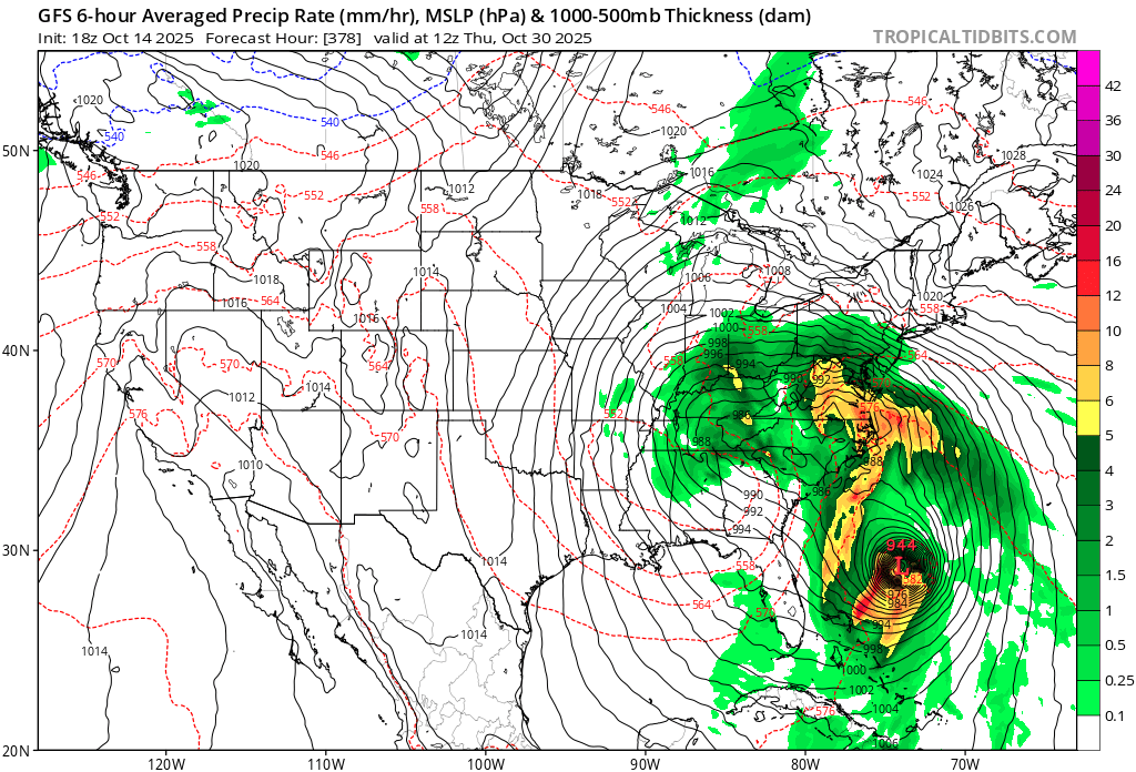
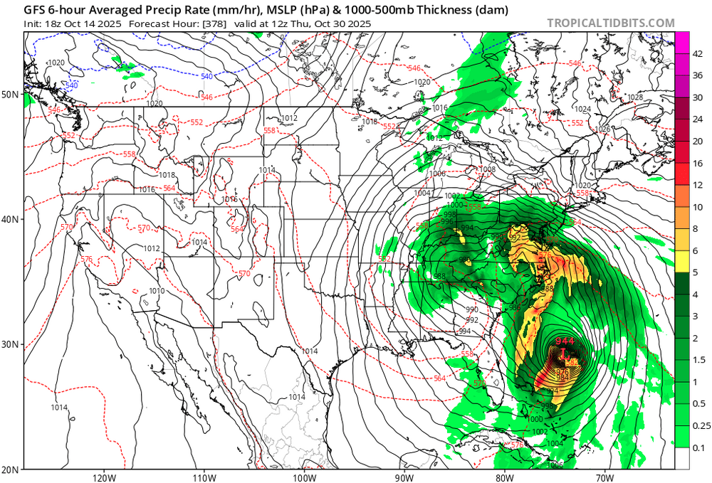
Sandy 2.0

-
Spooky Season (October Disco Thread)
Torch Tiger replied to Prismshine Productions's topic in New England
Yeah I've been looking, it's still a very coarse signal out of the Carib. I don't care if it impacts here, but let's see some impacts! -
That map isnt even close over this way. Might have been an inch or so. Consider the source.
-

Spooky Season (October Disco Thread)
ineedsnow replied to Prismshine Productions's topic in New England
Far out but I think either way there's going to be a big end of the month storm.. lots of fun on the ensembles for that time period. -
Spooky Season (October Disco Thread)
Torch Tiger replied to Prismshine Productions's topic in New England
that's my darling setup! Just a bit weak with 942mb and too far south. Looks late-season 1938ish though! -
Spooky Season (October Disco Thread)
Torch Tiger replied to Prismshine Productions's topic in New England
Yes!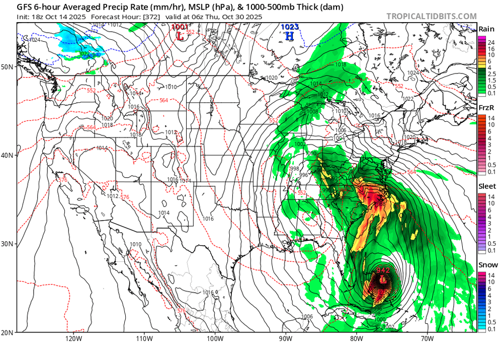
-
5 days later, has that misery look outside of a VERY cold anedecent airmass
-
6.60"..just persistent steady rain