All Activity
- Past hour
-
 can you buy zithromax over the counter in mexico: Z-Pack Supply - order zithromax over the counter
-

2026-2027 Record-breaking El Nino
snowman19 replied to Stormchaserchuck1's topic in Weather Forecasting and Discussion
-
can you take gabapentin and hydrocodone at the same time and can you freebase gabapentin a cosa serve il farmaco gabapentin https://clients1.google.ac/url?q=https://gabarxdirect.com gabapentin para el dolor or https://armandohart.com/user/ttosehjsuh/?um_action=edit what does gabapentin 100 mg do [url=http://tworzenie-gier.pl/wp-content/plugins/wp-js-external-link-info/redirect.php?blog=tworzenie+gier&url=https://gabarxdirect.com/]other medicines like gabapentin[/url] generic gabapentin 100 mg photos and [url=https://www.0468wudi.com/home.php?mod=space&uid=324945]can you take sudafed with gabapentin[/url] gabapentin headache prophylaxis
-
buy accutane discreet shipping and generic accutane 20mg buy buy accutane discreet shipping http://info56.ru/redirect.php?link=dermatretdirect.com buy isotretinoin 40mg capsules and http://www.garmoniya.uglich.ru/user/ucikuppyuw/ accutane discount pharmacy [url=https://maps.google.vu/url?q=https://dermatretdirect.com]where to buy accutane online safely[/url] accutane generic brands and [url=https://www.liveviolet.net/user/phukvhtauc/videos]accutane without ipledge[/url] cheap accutane online pharmacy
-
metoprolol succinate er: Pulse Guard Direct - metoprolol 50 mg side effects
- Today
-
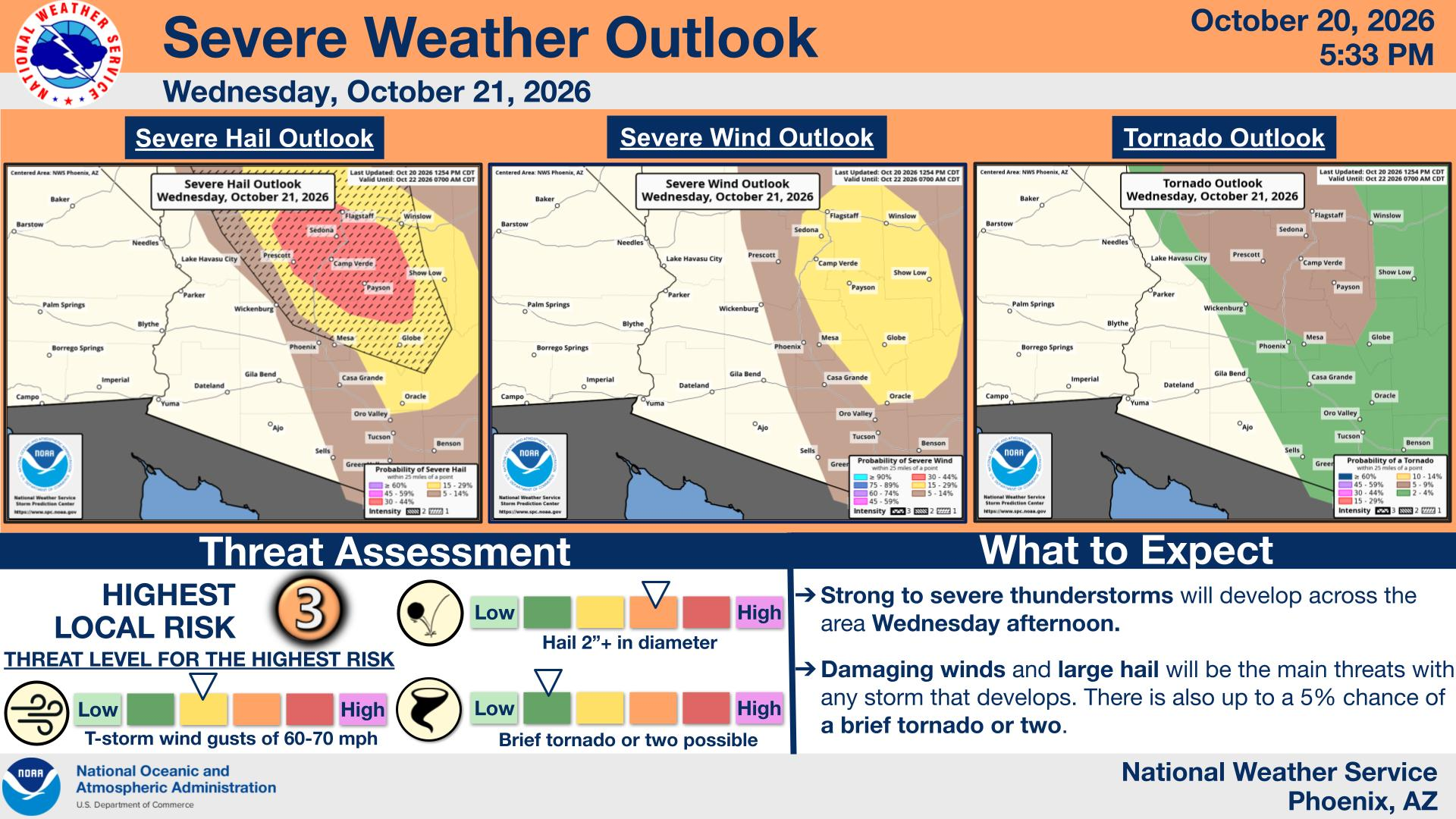
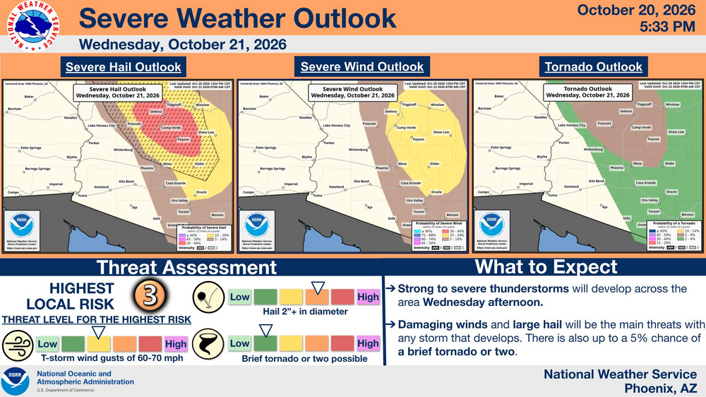
I know this is out of region, but interesting to me, and perhaps some others. Something to watch over the next 34-36 hours is an extremely rare severe outbreak potential over Central Arizona. From what I've heard and read, this is only the second time ever that the region was under an enhanced severe risk.
-
2026-2027 Record-breaking El Nino
snowman19 replied to Stormchaserchuck1's topic in Weather Forecasting and Discussion
-

2026-2027 Record-breaking El Nino
GaWx replied to Stormchaserchuck1's topic in Weather Forecasting and Discussion
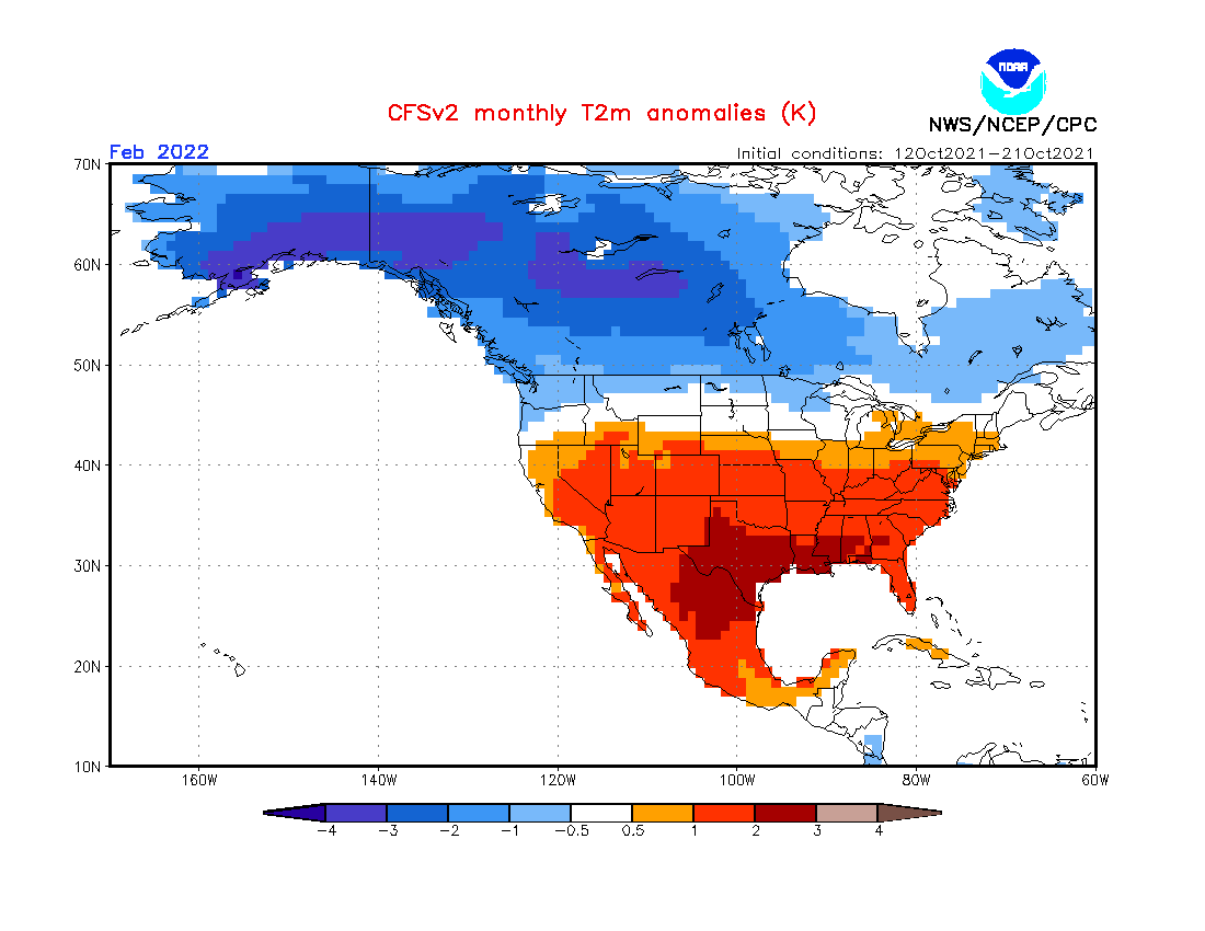
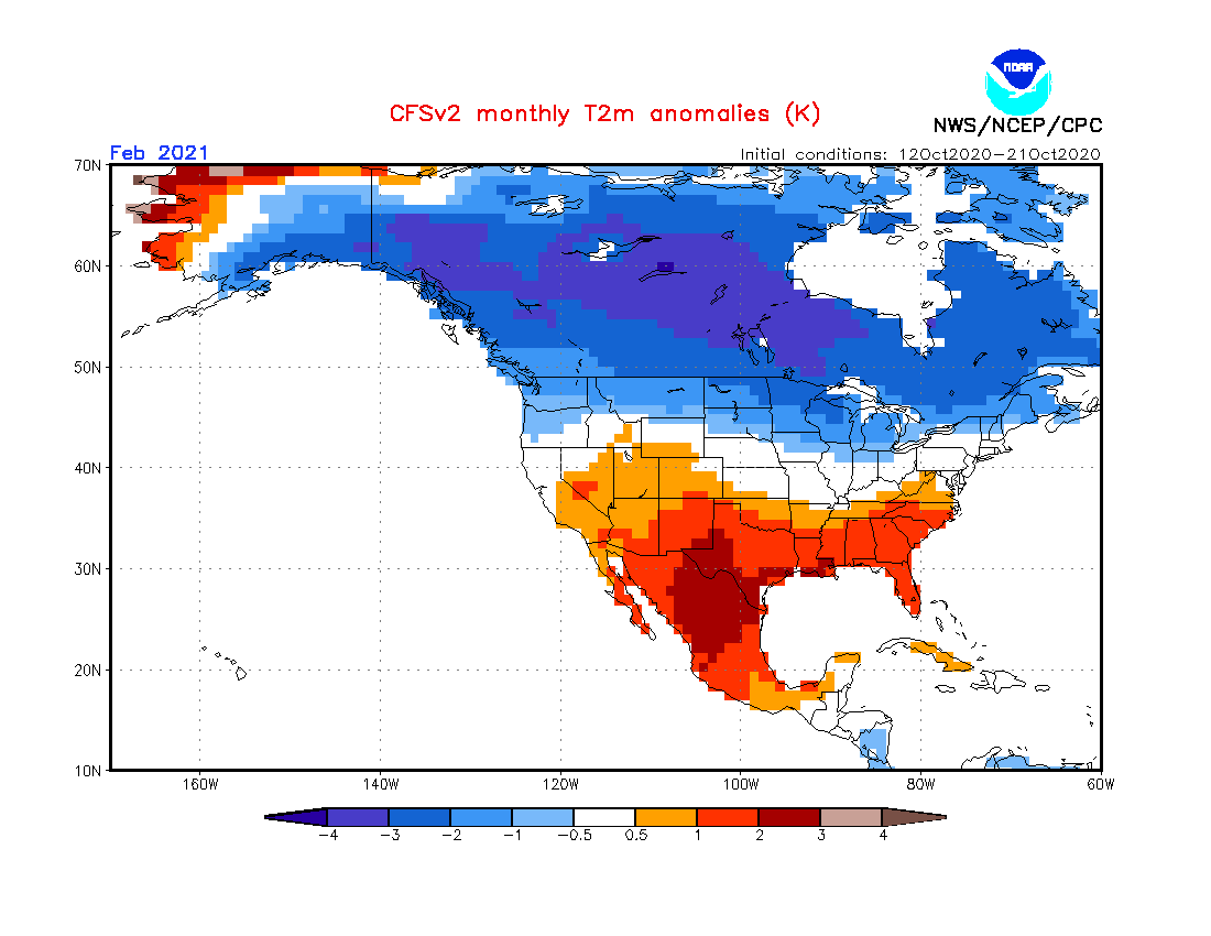
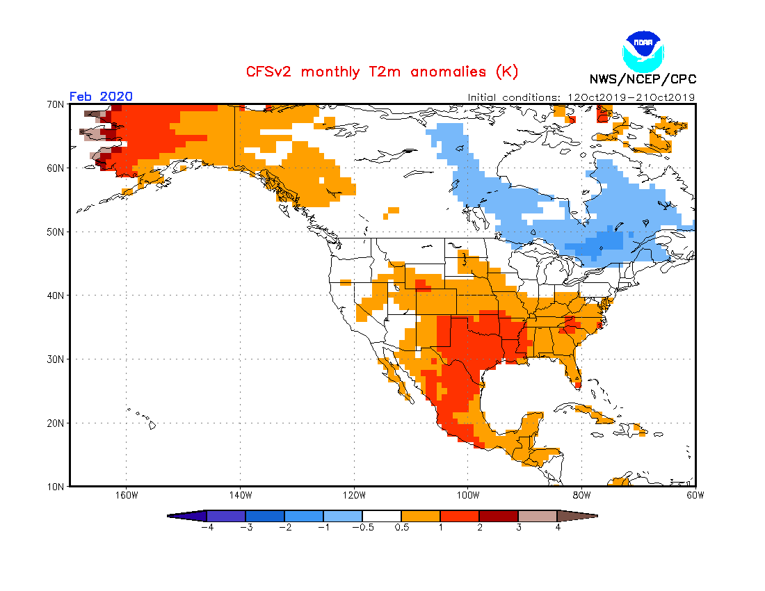
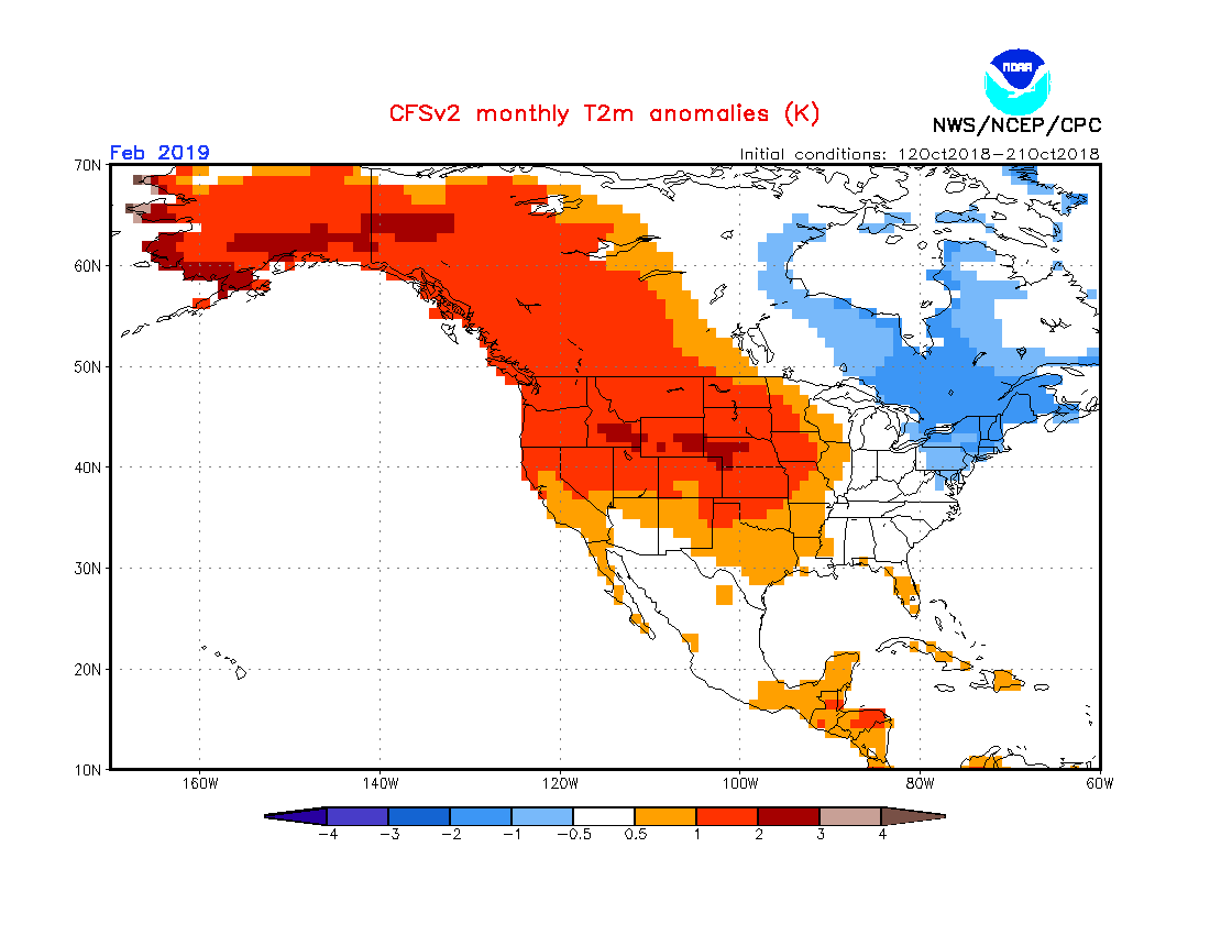
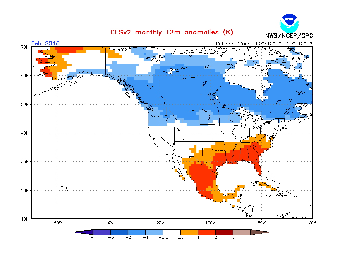
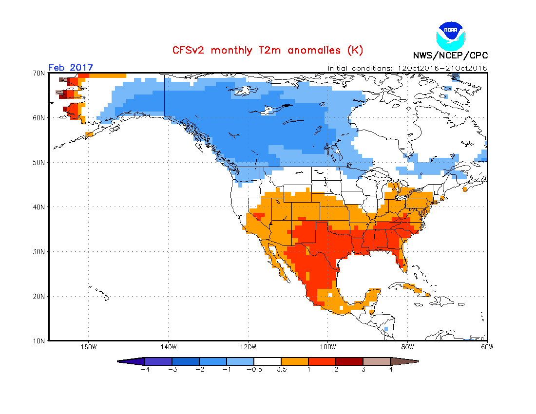
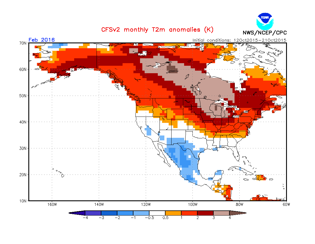
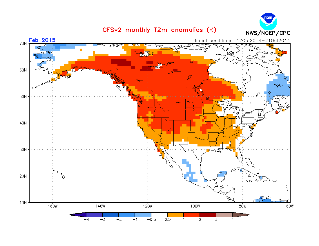
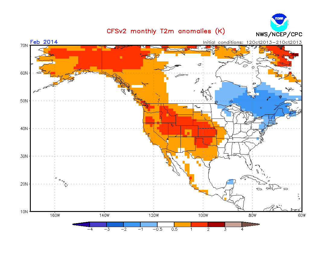
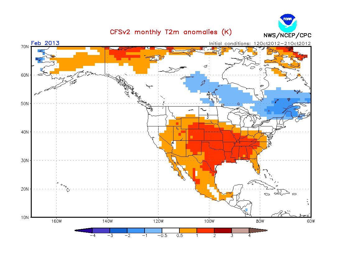
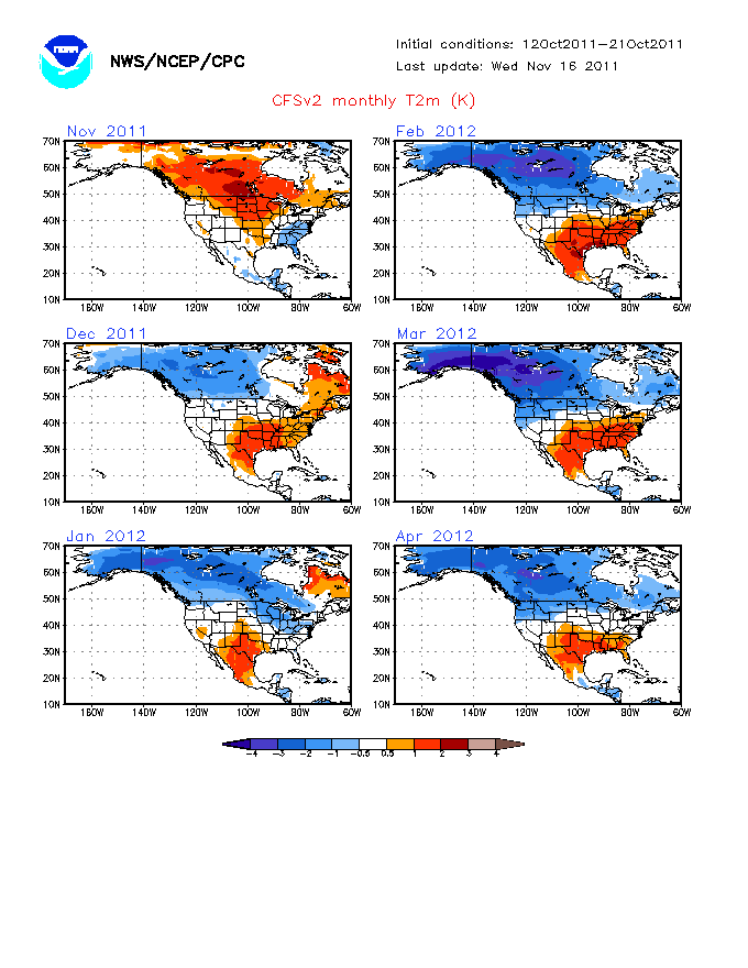
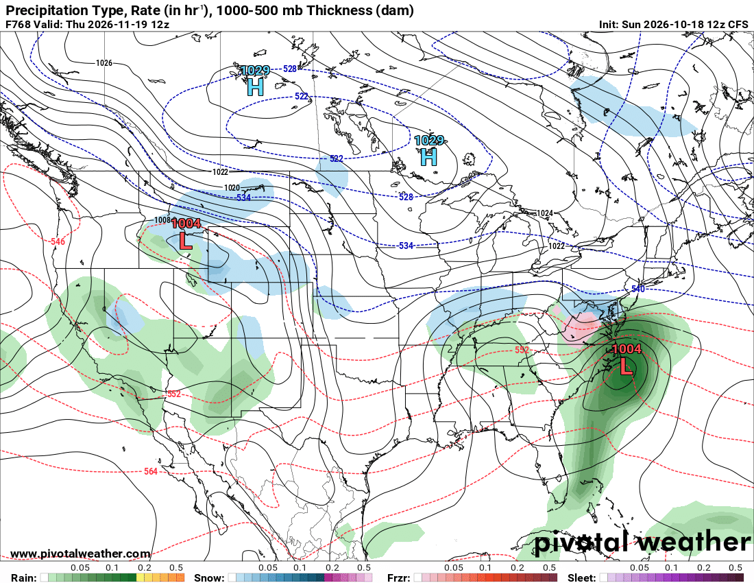
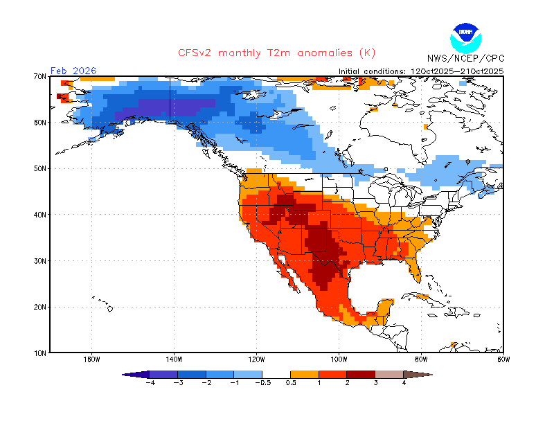
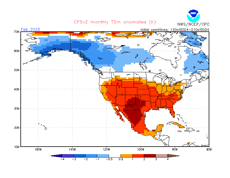
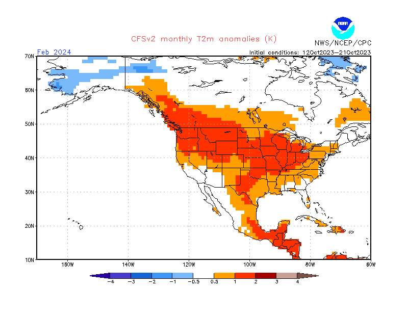
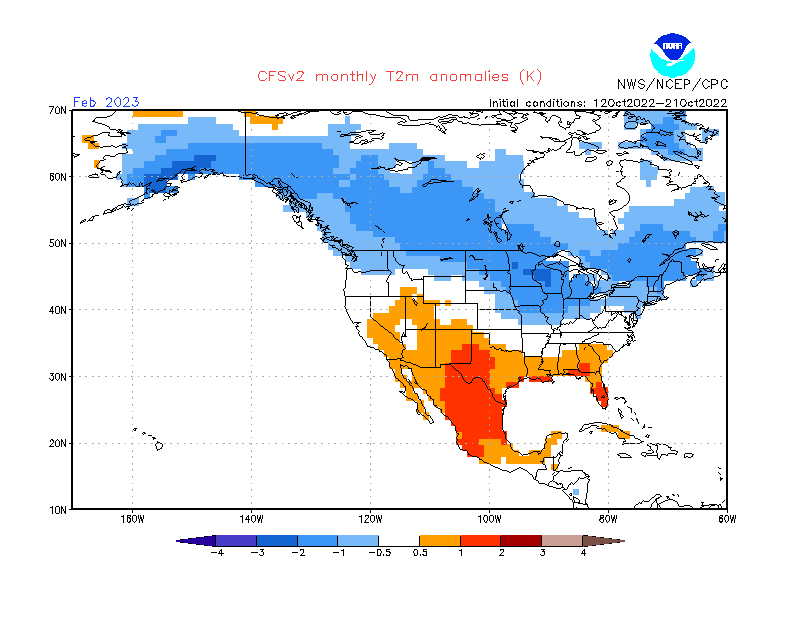
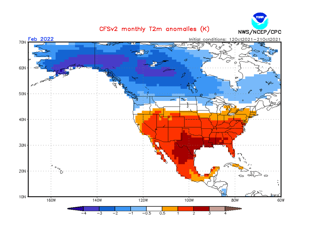
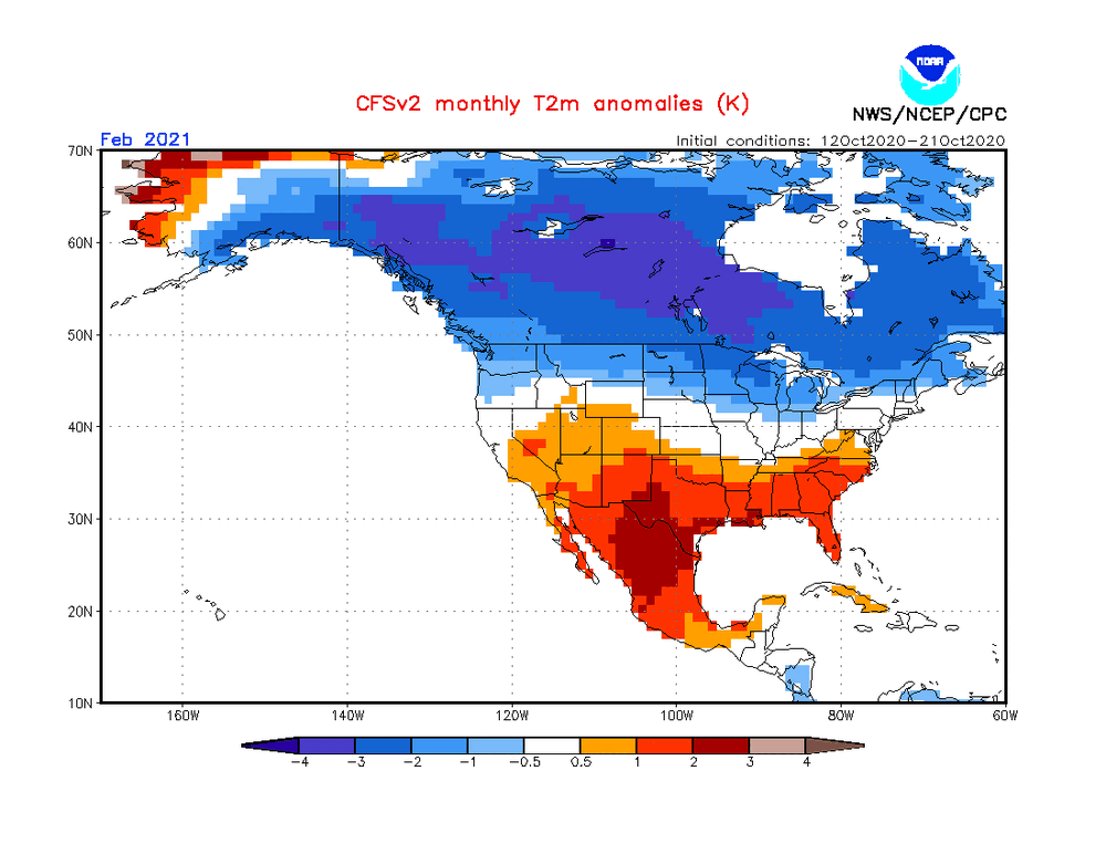
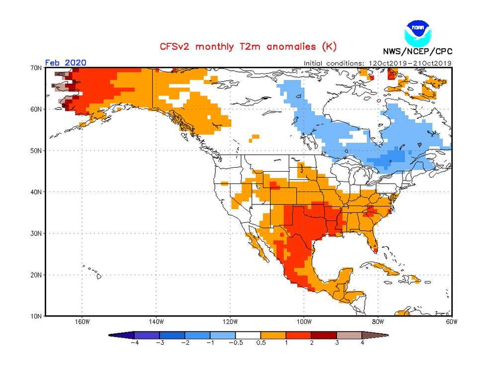
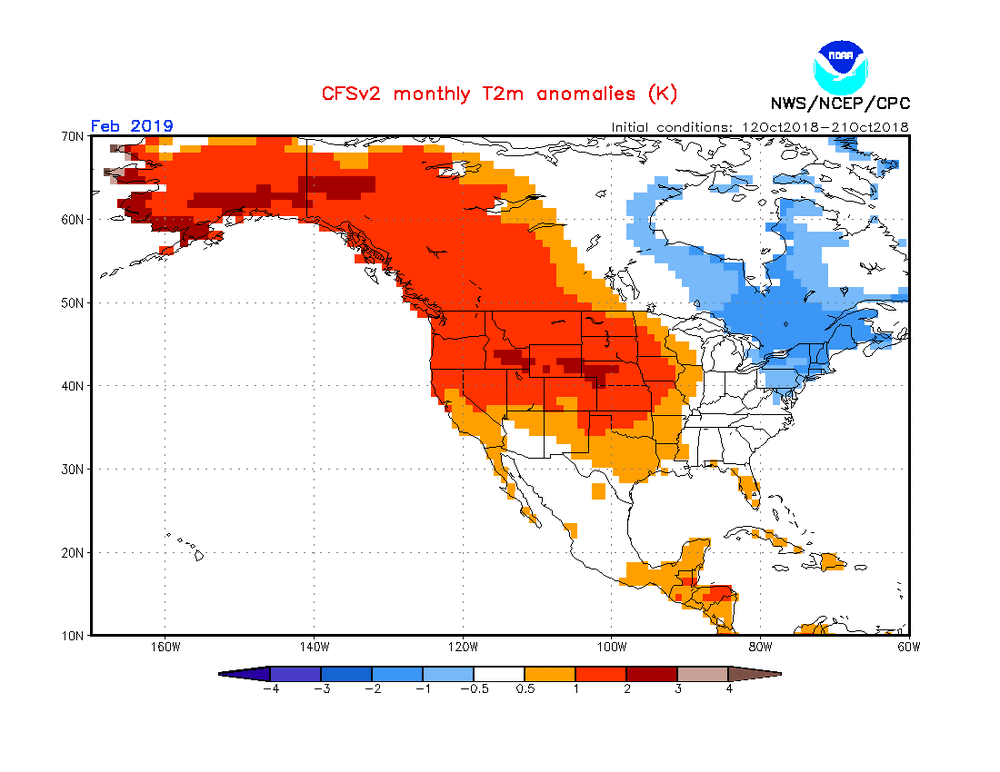
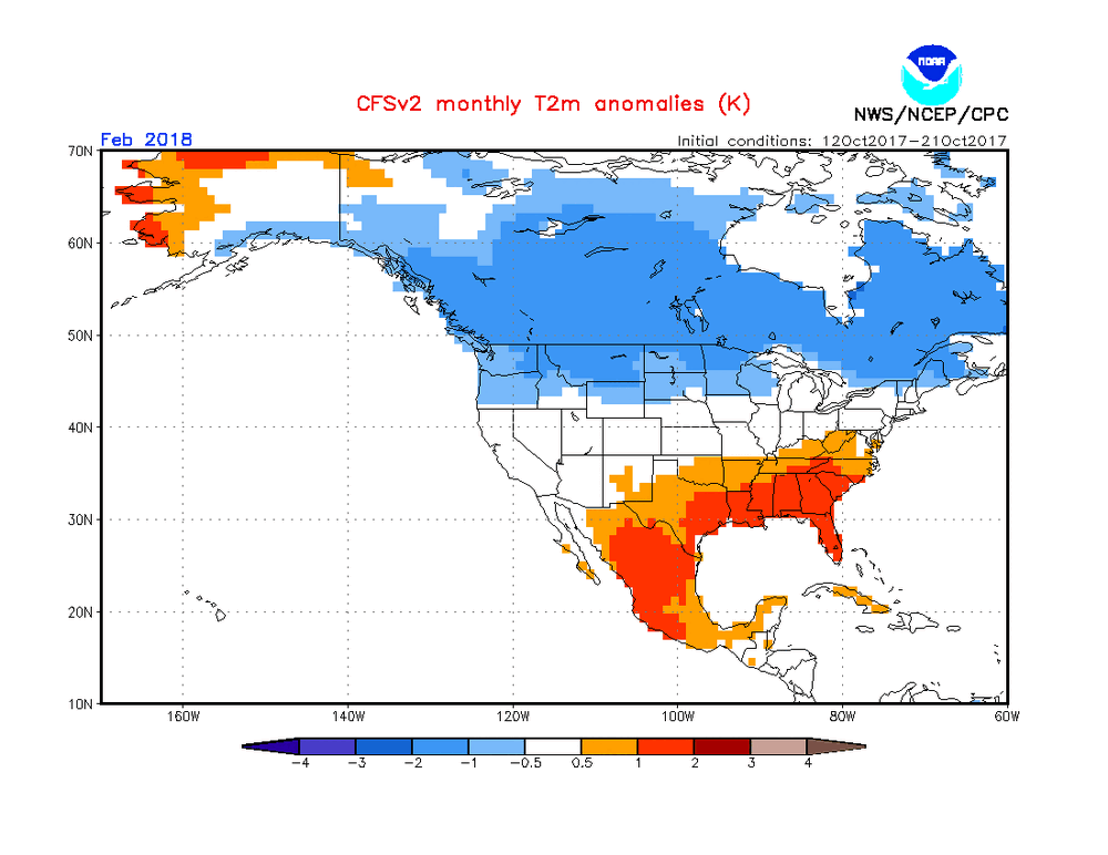
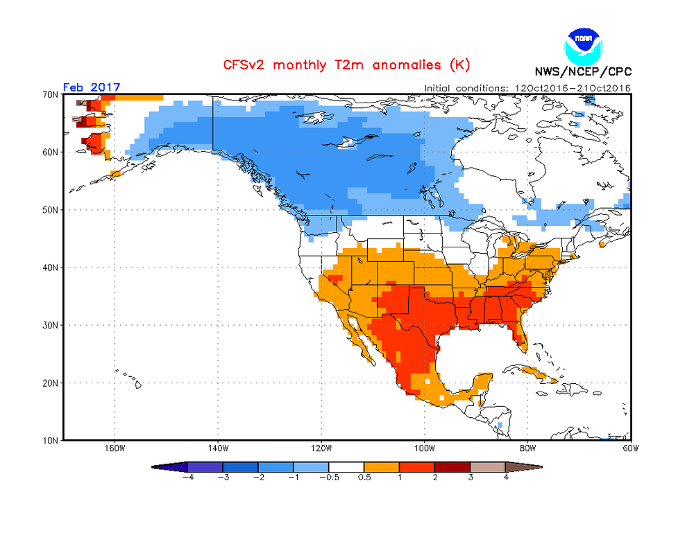
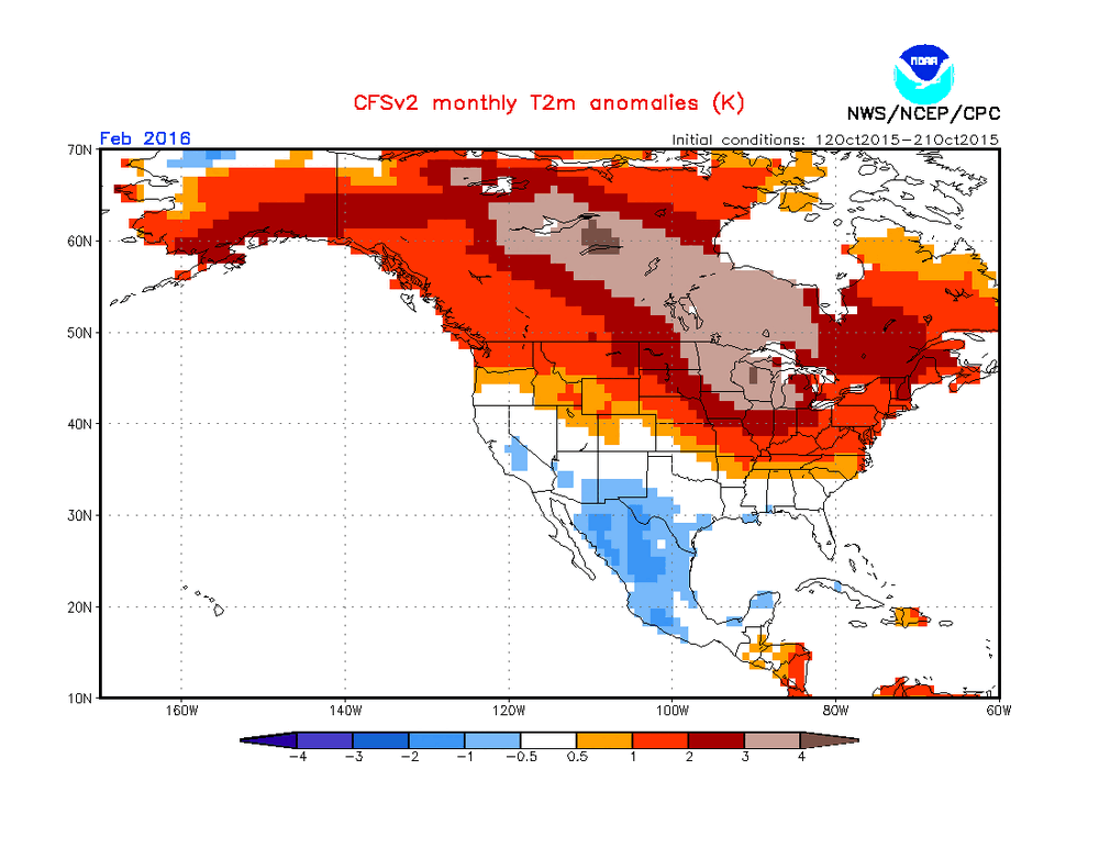
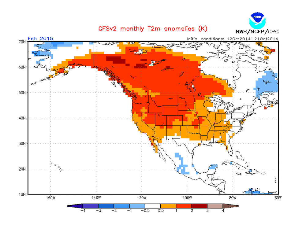
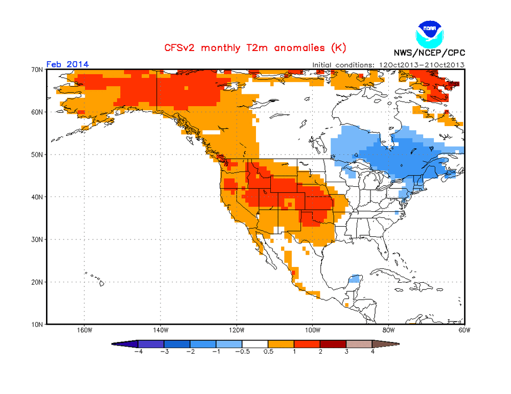
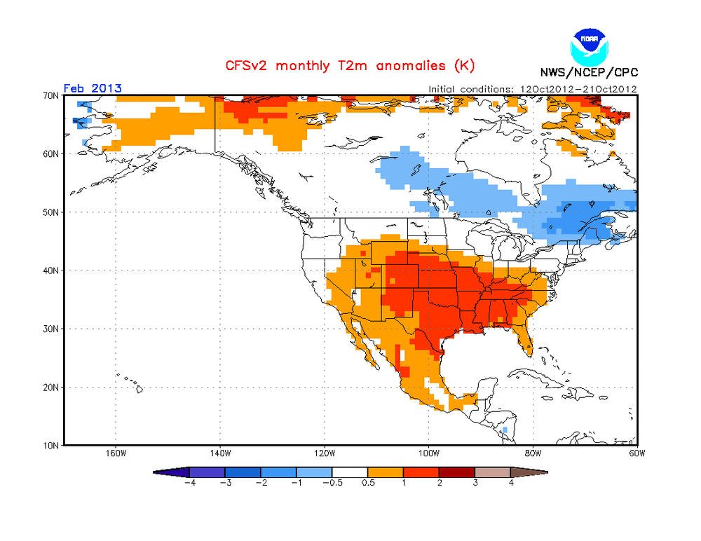
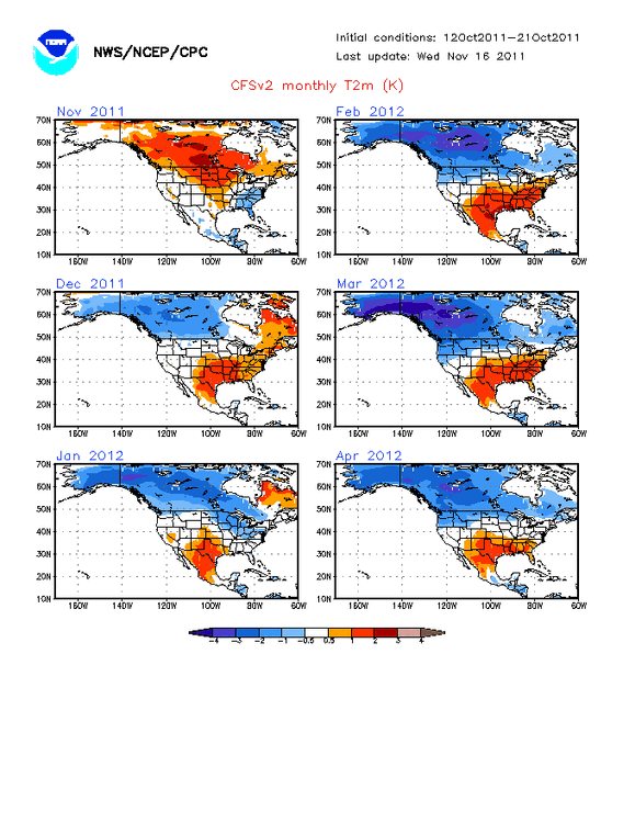
Anthony, Maybe this person saw this latest 10 day CFSv2 mean for Feb ‘27 (Nino): 80% of CONUS BN; much AN E Canada: No other mid Oct 10 day mean for Feb back to 2012 has had anything even closely resembling this extreme couplet, and a cold dominant Feb US/much warmer than normal E Can have been on EVERY 10 day mean since they started going out that far in mid August! Check out how much Feb of ‘27 differs from all other Feb forecasts back to the start of the CFSv2: 2026: 1% of CONUS BN; BN E Can: 2025: 0% of CONUS BN; BN E Can 2024 (Nino): 0% of CONUS BN; AN E Can 2023: 33% of CONUS BN; BN E Can 2022: 6% of CONUS BN; BN E Can 2021: 20% of CONUS BN; BN E Can 2020: 1% of CONUS BN; BN E Can 2019 (Nino): 5% of CONUS BN; BN E Can 2018: 20% of CONUS BN; BN E Can 2017: 3% of CONUS BN; BN E Can 2016 (Nino): 4% of CONUS BN; AN E Can 2015 (Nino): 0% of CONUS BN; BN E Can 2014: 4% of CONUS BN; BN E Can 2013: 1% of CONUS BN; BN E Can 2012: 15% of CONUS BN; BN E Can Feb: % BN Conus; E Can anom ‘27 (Nino): 80% BN US; much AN E Can ’26: 1% BN US; BN E Can ’25: 0% BN US; BN E Can ’24 (Nino): 0% BN US; AN E Can ’23: 33% BN US; BN E Can ’22: 6% BN US; BN E Can ’21: 20% BN US; BN E Can ’20: 1% BN US; BN E Can ’19 (Nino) 5% BN US; BN E Can ’18: 20% BN US; BN E Can ’17: 3% BN US; BN E Can ’16 (Nino): 4% BN US; AN E Can ’15 (Nino): 0% BN US; BN E Can ’14: 4% BN US; BN E Can ’13: 1% BN US; BN E Can ’12: 15% BN US; BN E Can ————————————— Analysis of above: -Feb of ‘27 80% BN US vs only 33% (‘23) for next closest! Avg of only 7.5% BN US for 2012-26 and a mere 2% BN for the four El Niño cases! -The other 4 Nino Febs had no more than 5% BN US! The two strongest Nino Febs had US BN of 0% (‘24) and 4% (‘16)! So, there’s virtually no resemblance to ‘27. -BN in the SE US virtually nonexistent on any of 2012-2026 with most of them mild. But in stark contrast, 2027 has a very cold SE! -Feb of ‘27 has by far the warmest E Can. Only 2 others had any degree of AN (much less intense than ‘27) and they were the 2 strongest El Niños (‘24 and ‘16). —————— In closing, Feb of ‘27 has been very persistently (for 2 months!) showing on the CFSv2 a highly unique (among all Febs on record) extreme couplet of a cold dominant CONUS and extreme blocking/very warm E Canada. The CFSv2 has been trying to tell us something it never has and though I’m not at all saying to trust it, I am suggesting that it not be dismissed.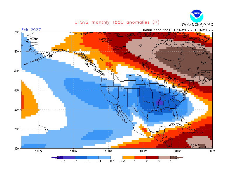
-
gabapentin cost: gabapentin actavis bivirkninger - gabapentin mod de administrare
-
-

2026-2027 Record-breaking El Nino
bncho replied to Stormchaserchuck1's topic in Weather Forecasting and Discussion
i can't believe my (A) eyes. -

2026-2027 Record-breaking El Nino
michsnowfreak replied to Stormchaserchuck1's topic in Weather Forecasting and Discussion
The 1990s winters here were WARMER than winters of the 1960s, 1970s, 1980s, 2000s and 2010s. Yes, the decade of the 1990s was colder than the intra decade block of 2016-2026. But actually the 90s still saw very slightly less snow than '16-26 too. And of course, there was a slew of mild to very mild winters in the 1930s-1950s. With the obsession some have with cc, lets not forget that weather also always has gone in cycles. When the snowy 2010s completed, the 1990s stood as the tamest winters here since the 1950s. So I get tired of the excuse that the nino of 97-98 was during some ice age climate lol. As for the old adage "its too cold to snow". Technically thats not true, however the cold is a very common contributor to suppression. Last winter was ranked a severe winter here due to its lasting cold and snowpack, but suppression absolutely stole our chance for above avg snowfall. -
lol the entire NFC East should be relegated - maybe pull in the top 2 each from the SEC and the Big 10
-
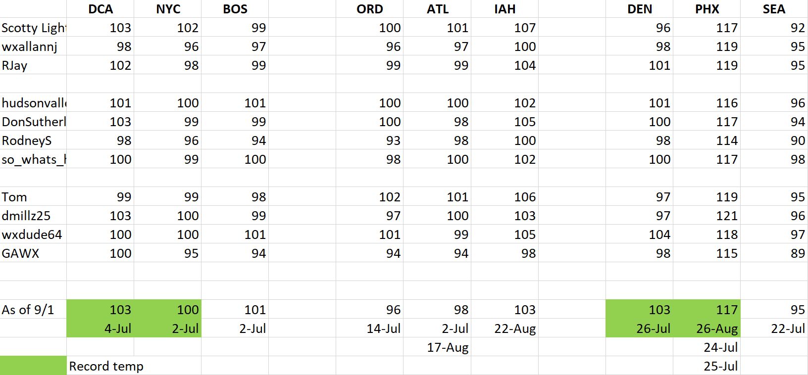
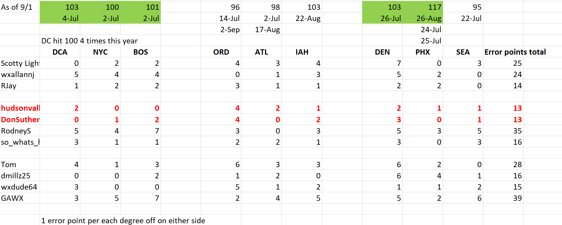
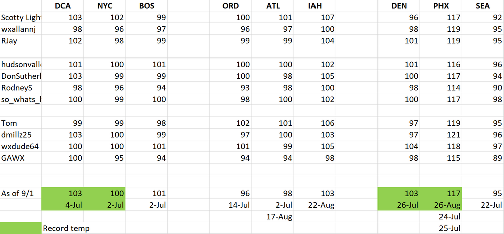
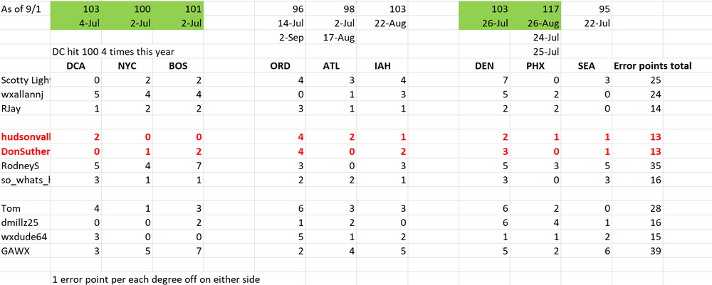
 Just wanted to make a quick update while I have some free time. Here are the results of the Max Temp forecast for each station. Green highlights a daily record high. DC managed 4 100+ degree days this year. Congrats to both Hudsonvalley and Donsutherland for a tie this year with some close contenders. I'll post in about a week about November forecasts.
-
https://zpacksupply.shop/# zithromax 250 mg australia
-
Well, almost everybody.
-
Holy AI slop
-
gabapentin tablets used: does gabapentin cause stomach issues - gabapentin late period
-
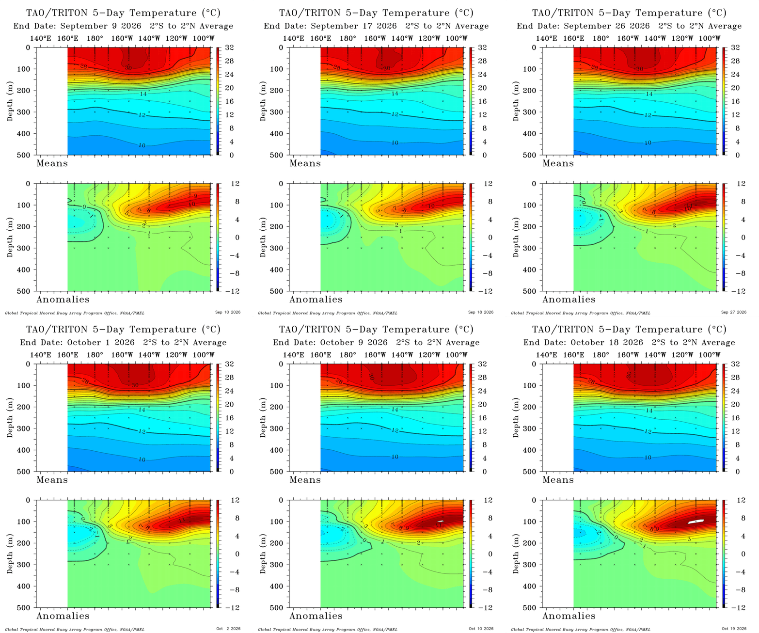
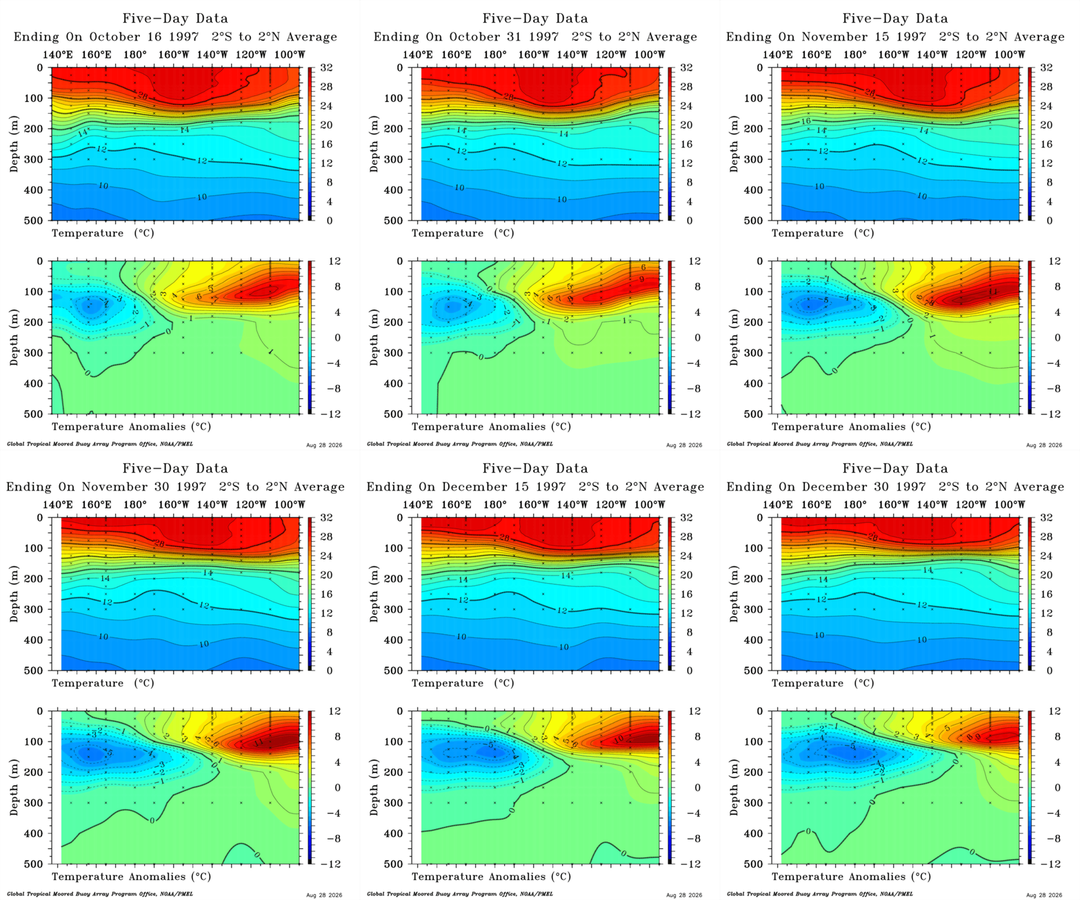
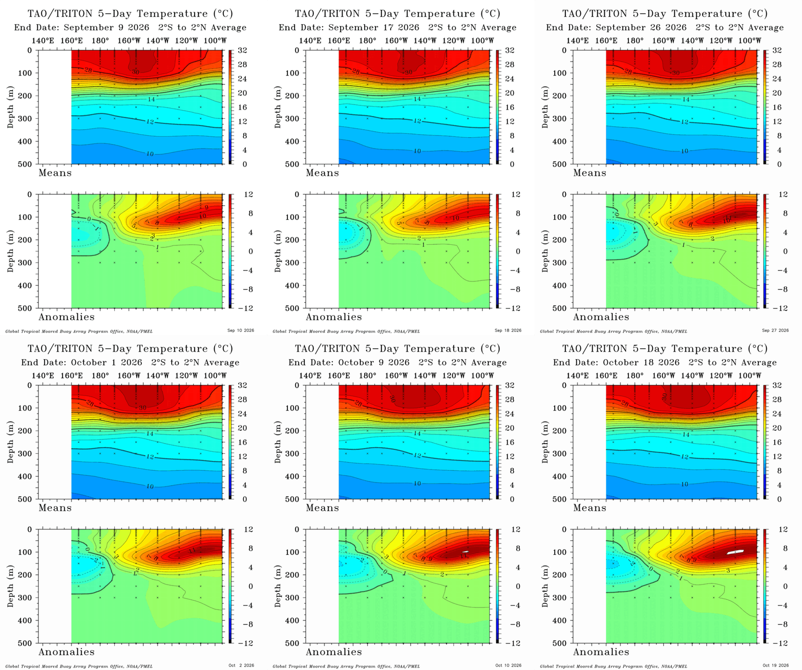
Here is roughly the last month and a half update. At this time of the +12c we were at Thanksgiving. Roughly about a month ahead of where we are in equivalency to 1997. We should know in the next 2 weeks how this works out but have this feeling we are done with significant warmings but rather how long this holds on compared to typical sst's which flatline now until about mid to late December.
-
I hear the flood gates open in November.
-
First time in NFL history a division goes winless for two consecutive weeks...I mean dang, lol
-
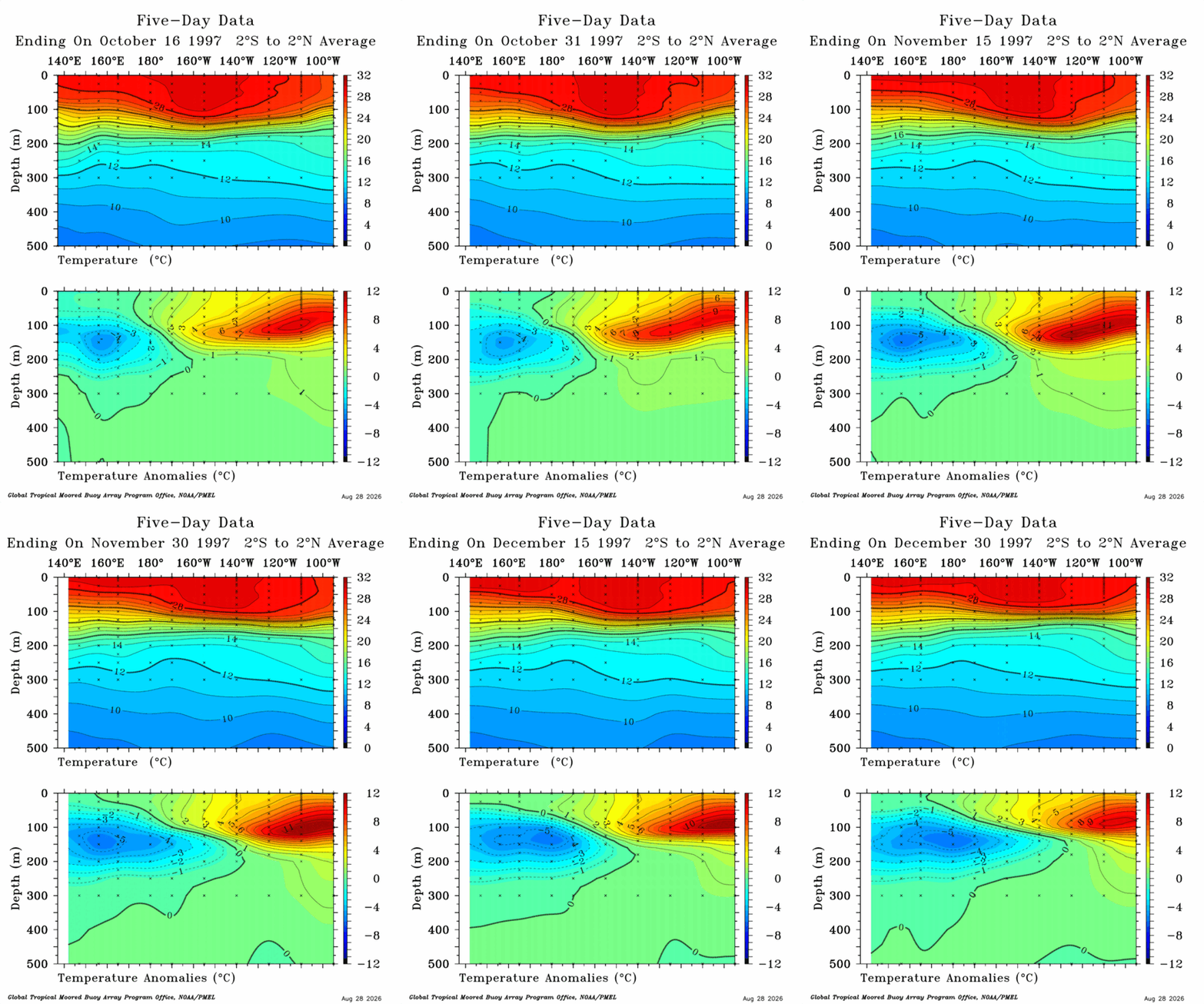
I don't know why but something feels off about that. 80W would be right on the immediate coastline which would maybe make the most sense right at the absolute surface not subsurface of 50-100m. Also we have seen a +12c subsurface before the only thing that has changed between 1997 and now is the average. On scale this is pretty inline with 1997 as for absolutes it is a whole different story.
-
buy canadian synthroid online [url=https://levocarepharma.shop/#]synthroid 88 mcg best price[/url] levothyroxine sodium 50 mcg buy
-
im so proud of you