All Activity
- Past hour
-

2026-2027 Super El Nino
bluewave replied to Stormchaserchuck1's topic in Weather Forecasting and Discussion
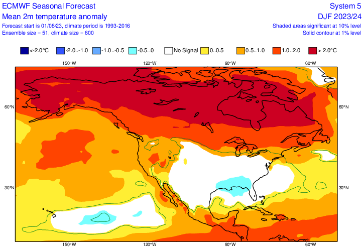
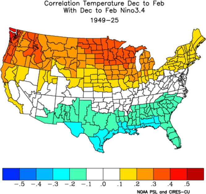
Super El Niños are significantly warmer than canonical El Niño patterns. None of the seasonal models were warm enough for either 2023-2024 or 2015-2016. This was probably the case also with whatever guidance they were using for the 1997-1998 winter forecast also. Correlations can give general ideas of which areas will be typically warmer or relatively cooler, but are not designed to handle extreme events like this one and the magnitudes of both 500 mb ridging and warmth. -
stfu already
-

2026-2027 Super El Nino
40/70 Benchmark replied to Stormchaserchuck1's topic in Weather Forecasting and Discussion
I think it's important not to automatically dismiss the correction towards default El Nino leading into the strongest El Nino in history. -
Been pretty consistent down pours all morning in warrenton. Sun peaks of for couple minutes and boom another down pour
-
About 5 miles N of Winchester on the east side of 81
-
I'm sure he picked up some today but the blob was definitely north of him this morning over me
-
2026-2027 Super El Nino
40/70 Benchmark replied to Stormchaserchuck1's topic in Weather Forecasting and Discussion
Right, but was there a trend towards a more defined se trough this late in the game? I feel like that is what is important because call me crazy, but this may just be the year when a correction towards default El Nino may be the correct adjustment. -

Winter 2026-2027 Speculation
Prismshine Productions replied to 40/70 Benchmark's topic in New England
Sent from my SM-S176V using Tapatalk -

2026-2027 Super El Nino
LakePaste25 replied to Stormchaserchuck1's topic in Weather Forecasting and Discussion
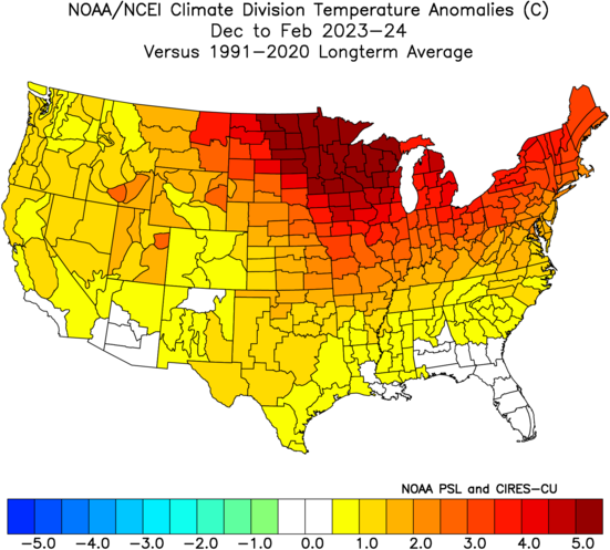
Makes sense to me. A stronger Nino would theoretically result in a stronger correlation to the canonical pattern that goes with it. That 23-24 map looks like it was showing warmer in both the W and SE compared to now which makes sense. -
0.46" today so far, 2.33" MTD. Ashburn
-
2026-2027 Super El Nino
bluewave replied to Stormchaserchuck1's topic in Weather Forecasting and Discussion
Looks to be defaulting to general El Nino correlations rather than an actual forecast for such an extreme event. We saw a similar forecast back in August 2024. The area to the north is warmer and Southeast cooler. Verification in °C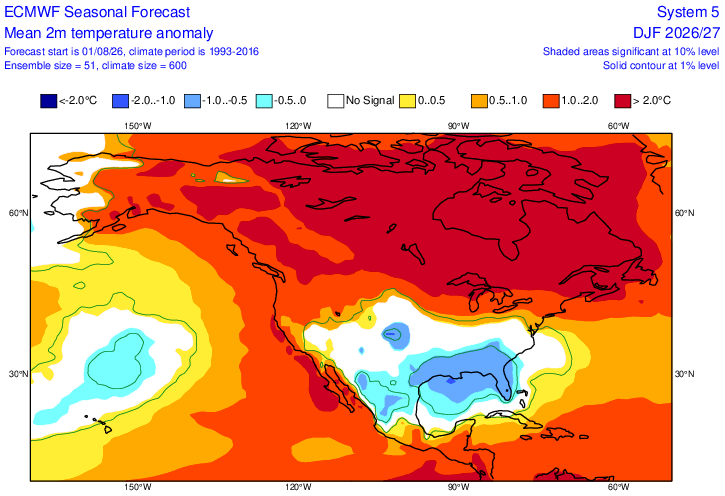
-
brief shower just now and .38 from overnight to current time
-
A real bon vivant. Just start a new account, loser.
-
I'm asking Randy since he's an admin. Better you keep your Jew hunting buddy here.
-
we'll get stebo right on that
-
We also had Irene in 2011.
-
Could you explain more what you mean by the bolded?
-

Augdewst 2026: Summer's Last Stand
CoastalWx replied to Prismshine Productions's topic in New England
Might get a S coast Seabreeze type deal Friday? Big CAPE on south coast with dewpoint pooling. However it might be capped….but I could see something pop. S/W moves through late Friday night with maybe more shwrs and storms. -
Maybe I’ve heard it before, couldn’t figure out the lyrics.
-
Can @stormtracker @admin reinstate @warywarren? He's Jew hunting me at another forum. He's @A-L-E-K close friend. So an antisemite.
-
Was surprised to see .62” in my gauge this morning.
-
Much much needed and welcome rain in Fallston starting pre-dawn and so far this AM. The fields at the farm really needed this kind of extended rain.
-
Usual spots W of the CRV have potential.
-
Winter 2026-2027 Speculation
Prismshine Productions replied to 40/70 Benchmark's topic in New England
At least you are cultured XD Sent from my SM-S176V using Tapatalk -
Winter 2026-2027 Speculation
Prismshine Productions replied to 40/70 Benchmark's topic in New England
Renegade by Styx, you never seen Supernatural? Sent from my SM-S176V using Tapatalk