All Activity
- Past hour
-

Central PA Spring 2026 Discussion/Obs Thread
pawatch replied to Voyager's topic in Upstate New York/Pennsylvania
Not so sure we will see 90’s on Tuesday north of I-80. -
Well see you next November for winter coverage because I’ve already canceled Atlantic Hurricane Season 2026 Don’t think I moved back yet but I def don’t remember this day.
-
Little bit of temp bust today, it was suppose to be low 70s and at 3pm it's only gotten to 65
-

2026-2027 Strong/Super El Nino
FPizz replied to Stormchaserchuck1's topic in Weather Forecasting and Discussion
Thanks. I thought predominantly from like Nov-Now minus like a 6 week break it wasnt like the map above. Carry on... -

Central PA Spring 2026 Discussion/Obs Thread
TheDreamTraveler replied to Voyager's topic in Upstate New York/Pennsylvania
I'm not really bitching about it I guess just having something to chat about that's relatable lmao I don't even really get in the water much at all. My main thing for even saying it is the fact those 2 days will probably be 2 of the hottest days of the entire summer and it happens this early instead of later which is stupid imo. Like if I ever do get in the pool it's only on really hot days like that but I get there's going to be a shit ton of days to get in it lol -

Central PA Spring 2026 Discussion/Obs Thread
WmsptWx replied to Voyager's topic in Upstate New York/Pennsylvania
Holy fucking Christ, you people are exhausting. It's May 15th. I've always considered swimming in May a bonus. It's been 50 degrees for the last month, that pattern seems to be breaking (and it's going to be in the low 60s next weekend so it's not even going to be extended warmth) and here we are. Bitching about the pool water. I may need to take a break. -
Hammer hitting it hard

-
Gonna need it trend a little warmer aloft I think for widespread 95+. Euro/GFS are around 18c or so at 850. I wanna see 19-20c with good mixing to lock 95+. Either way low 90s should be doable
-

2026-2027 Strong/Super El Nino
Stormchaserchuck1 replied to Stormchaserchuck1's topic in Weather Forecasting and Discussion
CPC 3-4 Week forecast going with an El Nino precip pattern.. should be interesting to see if it verifies, it's been running dry -
Yep...
-

2026-2027 Strong/Super El Nino
LakePaste25 replied to Stormchaserchuck1's topic in Weather Forecasting and Discussion
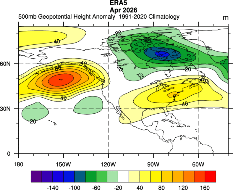
March and April were warm in the east. March was +6 here at ERI and April was +5.1.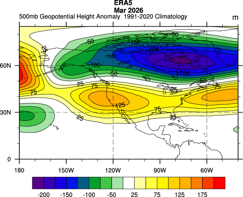
-
It’s got more mixing down there with larger mass flow off land versus slightly off water in SNE. Looks like a roaster to me away from the S Coast so we’ll see how it plays out.

-
Will be 95+ BDL/ CEF/ Merrimack Valley
- Today
-
storm prospects naso great imby but glad to be back in summer mode
-
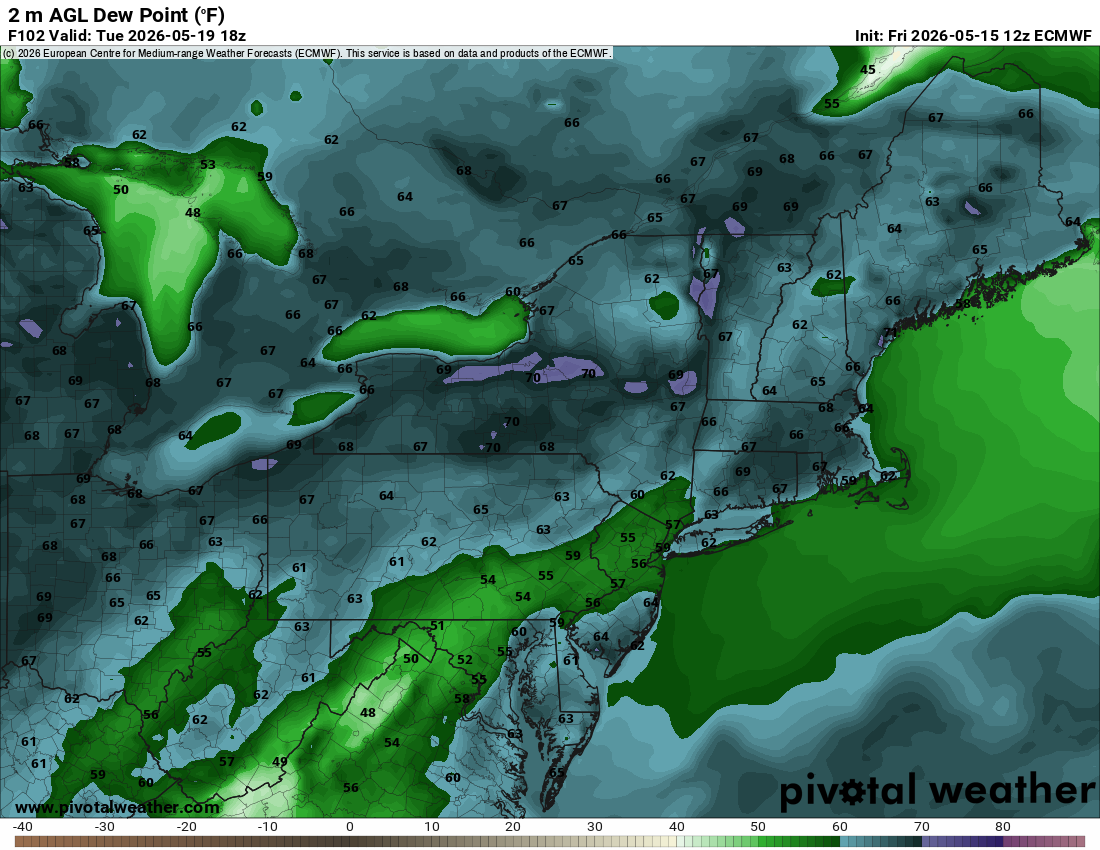
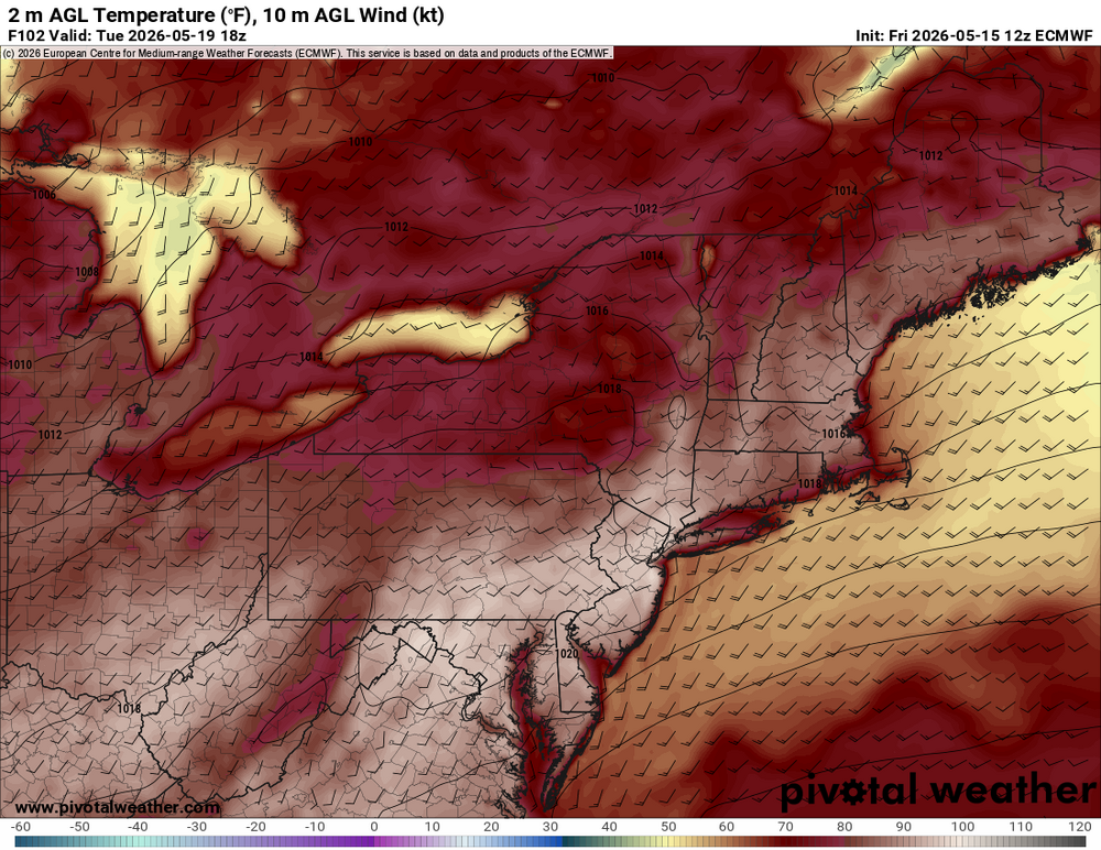
Euro's putting up big heat numbers in NYC's metro west and N NJ on Wednesday.
-
62 and overcast. Best climo.
-
I must be thinking if where they measure their snow then…
-
2026-2027 Strong/Super El Nino
FPizz replied to Stormchaserchuck1's topic in Weather Forecasting and Discussion
Hasn't it kind of looked like this for 7 months for the most part with the coolness in the Lakes/NE and very warm in the west? -

2026-2027 Strong/Super El Nino
A-L-E-K replied to Stormchaserchuck1's topic in Weather Forecasting and Discussion
-
Big time back off in the 12z GFS for the southern areas for sure, but the Larimer/Boulder foothills had essentially zero change. Around 16" for this area, while the 00z Euro shows 10-12", but I don't believe it at all unless this comes in colder. But the models have been trending colder for Monday, so we'll see.
-
2026-2027 Strong/Super El Nino
Stormchaserchuck1 replied to Stormchaserchuck1's topic in Weather Forecasting and Discussion
June Nino 3.4 -
beautiful friday to kick off the pattern transition
-

2026-2027 Strong/Super El Nino
snowman19 replied to Stormchaserchuck1's topic in Weather Forecasting and Discussion
-
May 17th/18th 2017. Something over 3 feet according to spotter reports. I didn't even bother trying to measure. The next day IIRC was about 70 degrees and it melted instantly LOL. But tree damage galore. My personal latest snow I've ever seen coming out of the sky was a long time ago (1997 or 1998 I think) when I lived in the Ohio snowbelt in Chardon, OH. I teed off on a round of golf in the morning during the first week of June with light snow falling.
-
2026-2027 Strong/Super El Nino
Stormchaserchuck1 replied to Stormchaserchuck1's topic in Weather Forecasting and Discussion
^The main correlation is in the NE Pacific and it doesn't look anything like it through the end of May. In June and July the ENSO-500mb correlation is weaker, but May is usually a pretty strong month, even with developing El Nino's.