All Activity
- Past hour
-
Erin is in the 80th percentile of MH in size and it'll continue to grow the wind field, so I could def see TS force winds on the OBX and maybe in a place like Nantucket. It's indisputable that the track has been too far east/north throughout Erin's lifecycle. As for the follow up wave, absolutely worth a watch. Casual for now, but the signal is there for another close approach. I don't think Erin is out in time to build a ridge that forces this into the Gulf...unless this develops further south. It looks like it's going to be near "ideal" for where I'd want to see a TC develop.
-

Hurricane Erin: 130 MPH - 942mb - NW @ 12
NotSureWeather replied to BarryStantonGBP's topic in Tropical Headquarters
Maybe some sustained convection in the NW quadrant for the first time it looks like. This thing is about to give us a seriously great satellite shot. -

Hurricane Erin: 130 MPH - 942mb - NW @ 12
wthrmn654 replied to BarryStantonGBP's topic in Tropical Headquarters
The track has been shifting more west. -
And just like that AHATT rolls over. There is no heat wave next weekend, the following week Is not going to be 85 to 90 . The best they can do is "well maybe Labor Day". We tried to tell em...
-
Honestly still watching Erin like @jbenedet mentioned in the tropical thread. That one could pump up the ridge a bit and cause Erin to move around a bit.. If that one can form quick enough .
-
may have to watch this follow up wave (like @WxWatcher007 mentioned). Its a better pattern then what we have now.
-
I got very lucky . Parts of Tolland had nothing. N side up by Stafford . It formed right on top of me
-
Now we sun
-
He had 1.77
-

Hurricane Erin: 130 MPH - 942mb - NW @ 12
Wannabehippie replied to BarryStantonGBP's topic in Tropical Headquarters
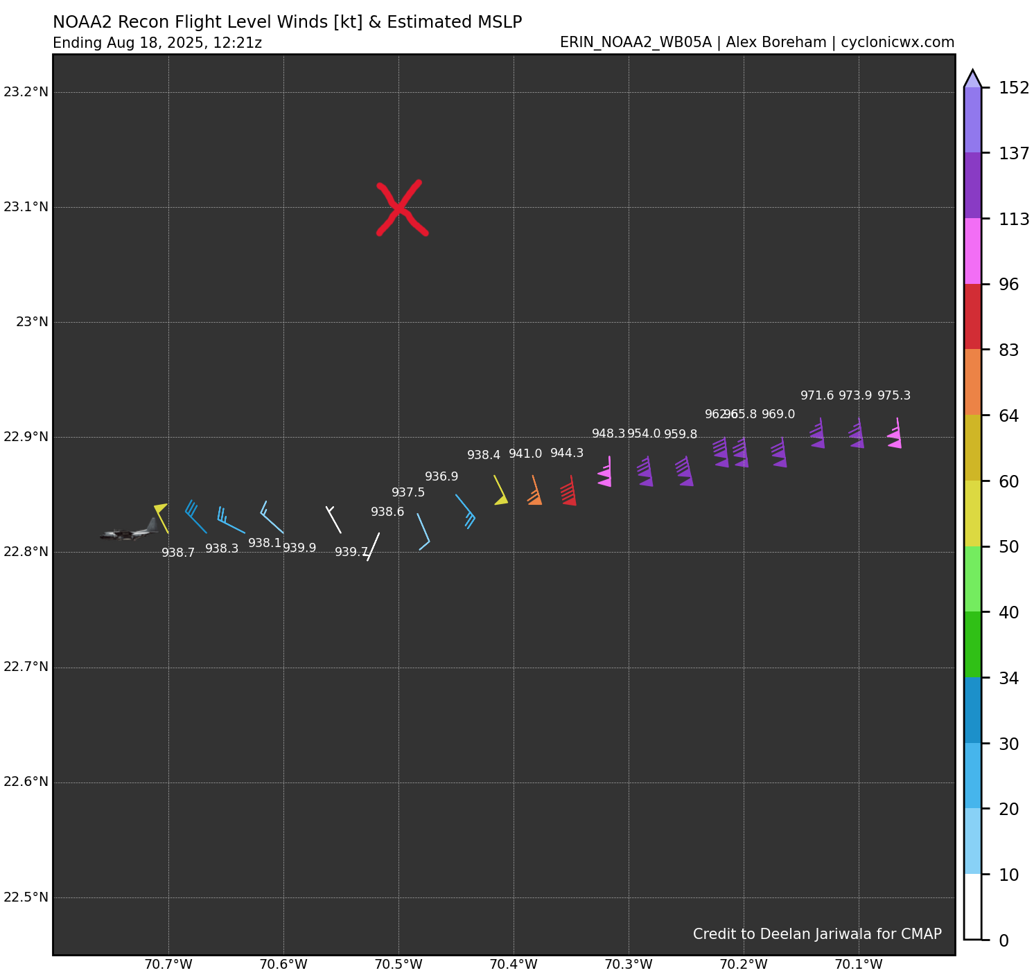
8:00 AM EDT Mon Aug 18 Location: 23.1°N 70.5°W Moving: NW at 13 mph Min pressure: 933 mb Max sustained: 130 mph -
Haven't seen Kevin respond but I think all that was south of him. He is near Crystal Lake which only had .17
-
59 low 66 at the moment... Very little air movement for now but some breeze is likely. Full sun has taken over as a sharp clearing line has moved S this last hour. Should make a run at about 72 or 73 for a stellar day. Subjectively a top 10er if this were April. Not so sure in mid August when folks expect 80, tho. Warm enthusiasm may take minor exception, while cold enthusiasm exaggerates significance without awareness that they are (lol) . This air mass is sneaky over-performing cold; not sure folks are really aware of that, nor why. If you look at the surface chart alone, you'd say ...well, you have a polar high bubble-no-trouble in Ontario pressing in. But that structure belies the fact that it is occurring as an anomaly relative to the hydrostatic heights - those being what is commonly referred to as "thickness". Both those, and the non-hydrostatic heights, are still positive. So we have a disproportionately cool low level relative to these metrics. It's more typical on a sunny day in mid August, when thicknesses are 567 dm, to have a surface T in the area of 82. The significance of that analysis is not hugely important to the everyday. However, I see evidences of this kind of warm anomaly ( "echo" ) occurring all the time, if perhaps hidden. Often masked by synoptic noise and/or hidden by a sensible appeal that suspends observing. It feels cool = gloat and don't look any deeper. As a digression... I've often mused that CC's biggest hurdle to overcome is the lack of impact it has to the actual five senses. It doesn't hurt enough? If it was at least more inconvenient. But being a "perceptively invisible" agent, or one that's not inconvenient enough either way, isn't helping it's case. If you want to appeal to the population, which as a bulk density that is too "dense" to anticipate via scientific interference (let alone, if the implication means they have to modulate their life), you need more than warnings from a scientific ambit that whatever reason is always the butt of jokes instead.
-

E PA/NJ/DE Summer 2025 Obs/Discussion
The Iceman replied to Hurricane Agnes's topic in Philadelphia Region
3.5” rain yesterday sheesh. We have 4.7” of rain now in August in 2 events lol -

Central PA Summer 2025
Mount Joy Snowman replied to Voyager's topic in Upstate New York/Pennsylvania
Low of 66 with .33” of rain and a much more refreshing airmass in place. -
should be that here soon
-
Still south of where the NHC has it.. I still think atleast the cape could get brushed pretty good and the Carolina coast . When the 12z hurricane models come out they will be initialized with the further north position.. guessing track shifts west a bit at 18z or 0z

-
I like an above normal September then I’m ready for cooler weather at the end of the month.
-
In the 40s this morning. First August rain (0.28") yesterday afternoon between 4:20 and 5. Enough breeze to bring down some early leaves but no thunder.
-
48.7F. Heat kicked on overnight
-
Yeah cloud pike south but clearing moving in from north
-
Yeah cool down next week and then moderate a bit.
-
Cloudy? It’s full sun and blue skies in Greenfield.
-
Looks like maybe another cool down next week then hopefully Labor Day weekend is summer like.
-
might have to switch to jeans, this blows. cool and cloudy gross
-
 Mt. Holly nearly 5"


.thumb.png.4150b06c63a21f61052e47a612bf1818.png)


