All Activity
- Past hour
-
My hunch on low off NC is no but it is going to be interesting to watch it's track and see what it delivers to the Mid-Atlantic area in terms of rainfall and wind gusts. As for the MDR region feature I'd say if it happens it will be after 9/17.
-

September 2025 OBS-Discussion centered NYC subforum
Sundog replied to wdrag's topic in New York City Metro
It's not out of the ordinary. -

September 2025 OBS-Discussion centered NYC subforum
nycwinter replied to wdrag's topic in New York City Metro
real summery feel outside this morning i cant believe in mid sept we are still having days like this.. -
They should leave you alone. It’s getting frozen out in another month or two anyway.
-
Dew the dew next weekend. Likely some frost chances where it can decouple given those afternoon Tds.
-
I pray it will at least be interesting and throw down a few surprises. Lots of different early casting around the world right now.
-
Though boring for tracking, I think it’s absolutely fascinating what’s been going on this Sept so far. The last time Sept had no TC this far into the month was way back in 1992! It had its first Sep TC on Sep 17th. If 2025 doesn’t get a TD+ by Sep 17th (going to be close because of many models progging the current E MDR AEW to become a TD near or just after that day; also have to make sure the low off NC doesn’t do the same), then 2025 would have the latest 1st Sep TC since 1939’s Sep 23rd! Any predictions on whether either the current MDR AEW or the low off of NC will reach TD status by Sept 17th?
-
Upstate SC Spartanburg...Gaffney...Union areas getting very dry as well and people with sinus and headache issues are really feeling the pressure increase
-
I have to cut the lawn at some point near this thing. Not a fan of hornets. Don't they have people that can remove these without killing them? Sent from my SM-S921U using Tapatalk
-

September 2025 OBS-Discussion centered NYC subforum
Picard replied to wdrag's topic in New York City Metro
It got quite threatening looking up here in the afternoon and evening yesterday. Nothing, not even a drip. Everything was well east. -
@CAPE https://www.espn.com/nfl/story/_/id/46245106/ravens-planned-take-shedeur-sanders-draft-sources-say Would have been interesting to see
-

September 2025 OBS-Discussion centered NYC subforum
anthonymm replied to wdrag's topic in New York City Metro
With no cool downs in sight September might average seasonable if not slightly above normal no? Much warmer looking nights ahead as well. - Today
-

September 2025 OBS-Discussion centered NYC subforum
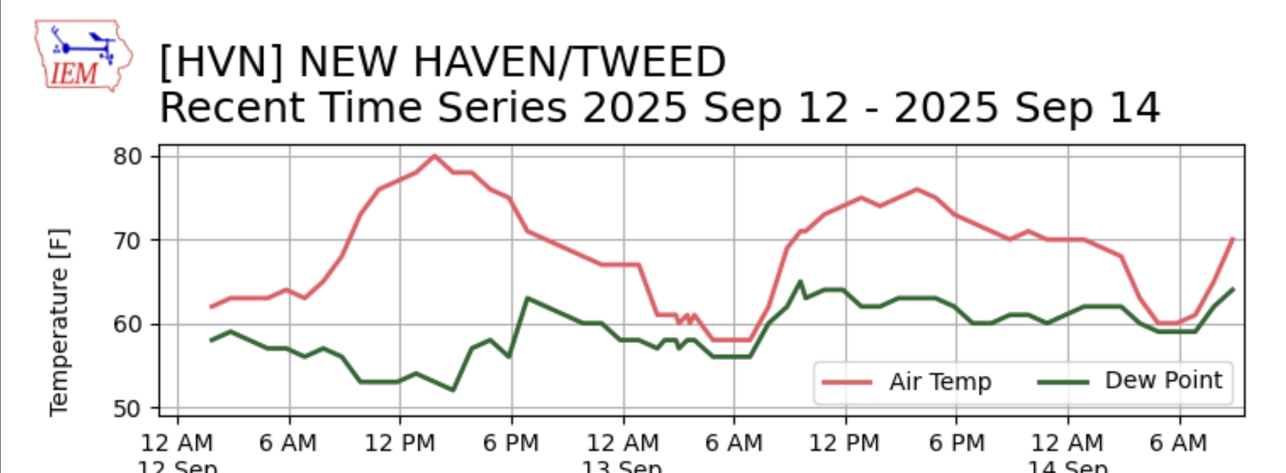
wdrag replied to wdrag's topic in New York City Metro
Late yesterday (9/13/25) shower amounts via CoCoRaHs Click if in disbelief.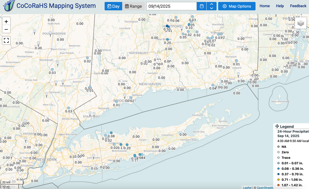
-
Ooph. Just found this big hornets nest in our ornamental tree Sent from my SM-S921U using Tapatalk

-
Thanks, Snowman. 1. Agreed. I think it’s absolutely fascinating what’s been going on this peak season so far. The last time Sept had no TC this far into the month was way back in 1992! It had its first Sep TC on Sep 17th. If 2025 doesn’t get a TD+ by Sep 17th (going to be close because of many models progging the current E MDR AEW to become a TD near or just after that day; also have to make sure the low off of NC doesn’t become a TD), then 2025 would have the latest 1st Sep TC since 1939’s Sep 23rd! 2. But to clarify, predictions from reputable forecasters were for slightly to moderately above avg activity rather than hyperactive. Also, mine (which can be seen in the AmerWx Contest thread) was for only slightly above avg ACE of 139 as well as 14 NS, 9 H, and 3 MH: 2. Don, Chris, and myself found with our research over the last month and posted ITT that any correlation between ACE and NYC snowfall the following winter has been weak at best. So, it not being hyper doesn’t say much as regards NYC snowfall prognosis. The slight correlation at best means the chance this season of 35”+ there in 25-26 is decreased only a little by a not AN ACE season.
-
September 2025 OBS-Discussion centered NYC subforum
Sundog replied to wdrag's topic in New York City Metro
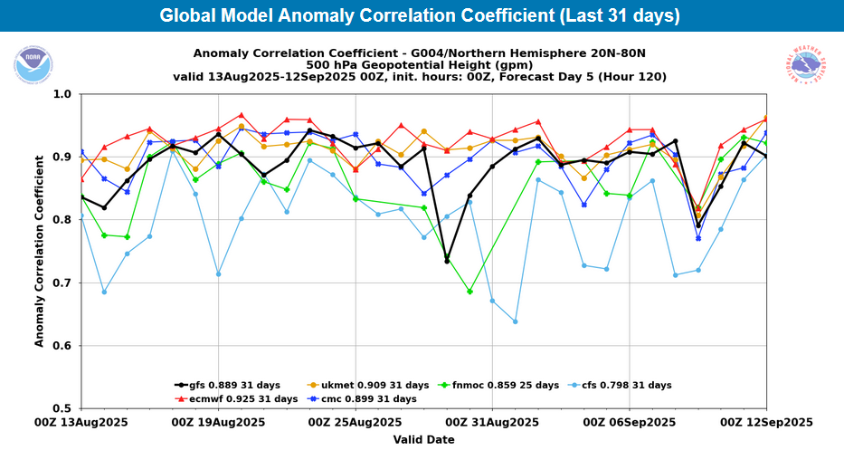
Excellent post Don. I've been saying for years that a model's usefulness goes far behind it's 500mb hemispheric score. -

September 2025 OBS-Discussion centered NYC subforum
donsutherland1 replied to wdrag's topic in New York City Metro
For reference, the ECMWF and EPS have been running a fairly strong warm bias in the short range. Meanwhile, the ECMWF continues to rank first in 500 mb anomaly scores: This divergent outcome is a reminder that there is more to forecasting than 500 mb maps. All the details matter. In terms of specific numbers, below were the 9/12 0z EPS forecast highs for Central Park: September 13: 80 (actual: 77) September 14: 86 September 15: 83 September 16: 82 September 17: 83 September 18: 84 September 19: 81 Below were the 9/12 0z ECMWF forecast highs for Central Park: September 13: 80 (actual: 77) September 14: 86 September 15: 84 September 16: 82 September 17: 86 September 18: 90 September 19: 87 Today could reach the lower 80s, tomorrow may reach 80°, Thursday has a shot at 80°, and Friday could be the warmest day, reaching the lower and maybe middle 80s. Interior sections of NJ will be warmer and Friday could see upper 80s there.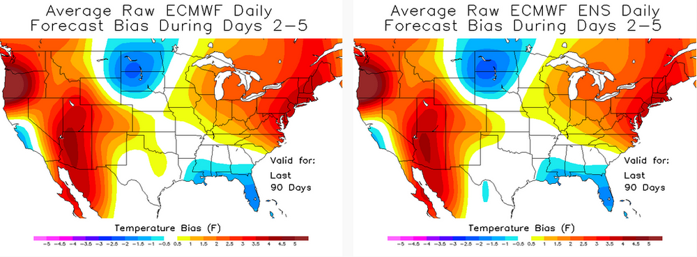
-
Let's dew it..
-
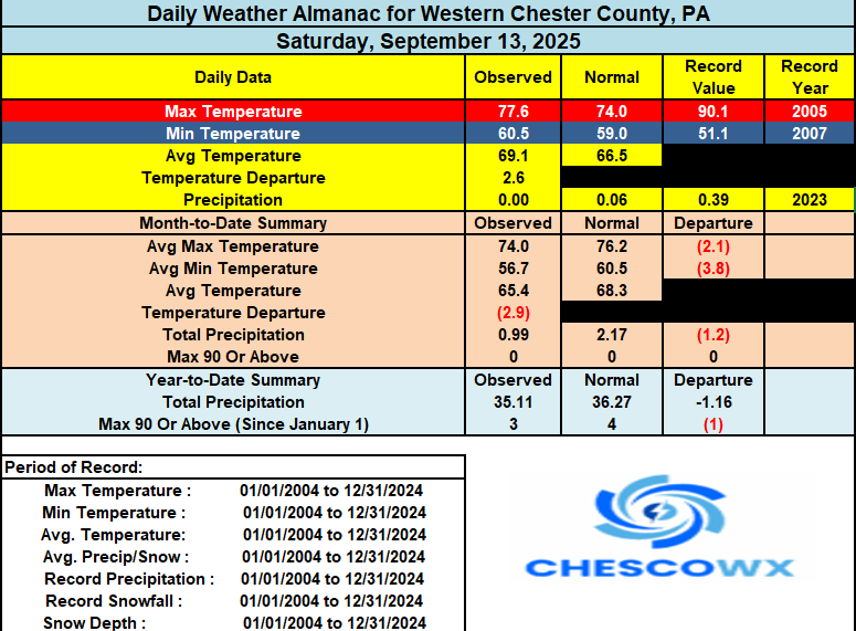
Temperatures should again run a bit above normal today and Monday before we turn a bit cooler and see at least some much needed rain chances for Tuesday night through Wednesday. Looks cooler again by next weekend.
-
We could really use it. Been dry here. Grass is getting crunchy.
-
(002).thumb.png.6e3d9d46bca5fe41aab7a74871dd8af8.png)
E PA/NJ/DE Autumn 2025 Obs/Discussion
ChescoWx replied to PhiEaglesfan712's topic in Philadelphia Region
Temperatures should again run a bit above normal today and Monday before we turn a bit cooler and see at least some much needed rain chances for Tuesday night through Wednesday. Looks cooler again by next weekend.
-

September 2025 OBS-Discussion centered NYC subforum
Santa Claus replied to wdrag's topic in New York City Metro
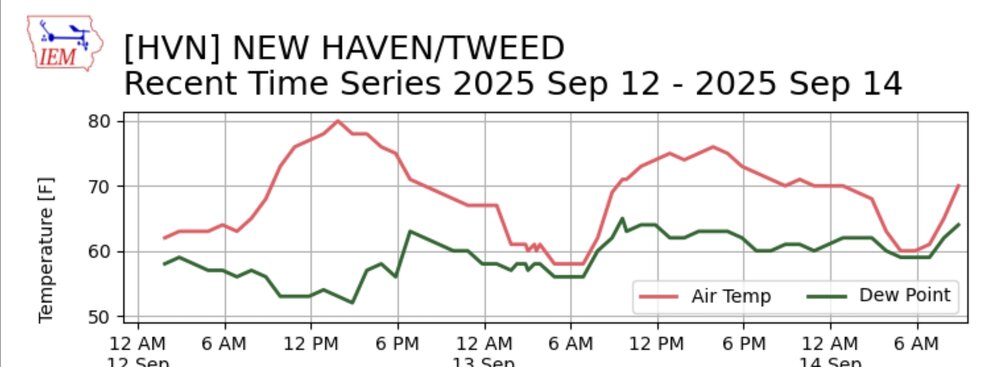
warm morning under that bright blue sky. the sun still got hands -
Looks pretty warm down this way..
.png.8ec6dc471417106ffeedab18b04b6913.png)
-

September 2025 OBS-Discussion centered NYC subforum
SACRUS replied to wdrag's topic in New York City Metro
Highs: EWR: 94 (2016) NYC: 93 (1931) LGA: 92 (2016) JFK: 89 (1995) Lows: EWR: 45 (1975) NYC: 45 (1975) LGA: 48 (1975) JFK: 48 (1975) Historical: 1824: A hurricane storm surge swept over the islands of the Georgia coast with a great loss of life, destruction of crops, and severe floods inland. (Ref. Wilson Wx. History) 1912: Hurricane makes landfall just west of Mobile, Alabama. (Ref. AccWeather Weather History) 1919: 357 people died as a hurricane made landfall near Corpus Christi, TX. A 16 foot storm surge inundated the low-lying areas, destroying almost all of the wooden buildings. Port Aransas was almost totally demolished. Damage totaled $20.3 million dollars. (Ref. Wilson Wx. History) 1928: A violent, estimated F4 tornado, with winds of 200 mph, tore across Rockford, Illinois. The tornado first touched down 8 miles south-southwest of Rockford and moved across the southeast part of the city. The tornado was on the ground for 25 miles with a width varying from 200 to 500 feet. A total of 14 people were killed, with around 100 injuries reported in Rockford alone. Two hundred buildings were damaged or destroyed. 1937 - The mercury soared to 92 degrees at Seattle, WA, a record for September. (The Weather Channel) 1944 - A very destructive hurricane swept across Cape Hatteras and Chesapeake Bay, side swiped New Jersey and Long Island, and crossed southeastern Massachusetts. The hurricane killed more than four hundred persons, mainly at sea. The hurricane destroyed the Atlantic City NJ boardwalk. (David Ludlum) (The Weather Channel) 1960: Hurricane Ethel developed rapidly in the central Gulf of Mexico early on this date, intensified and moved northward with winds estimated as high as 130 mph near the center late on this date. Ethel went from a tropical storm to briefly a Category 5 within 18 hours. Ethel decreased in intensity rapidly before reaching the coast near the Alabama- Mississippi border on the 15th as a minimal hurricane. Hurricane force winds were reported in Plaquemines Parish, Louisiana, including Venice which reported sustained winds of 90 mph and gusts of up to 105 mph. Rainfall totals ranged from 2 to 10 inches. Damage was estimated at $1 million dollars and no fatalities were reported. Despite attaining Category 5 intensity, Ethel name was not retired. (Ref. Wilson Wx. History) 1970 - The temperature at Fremont, OR, dipped to 2 above zero to equal the state record for September set on the 24th in 1926. (The Weather Channel) 1971: A strong ridge was in place across the west giving very high temperature included: Palm Springs, CA: 114°, Phoenix, AZ: 109°, Victorville, CA: 108°, Fresno, CA: 105°, Stockton, CA: 104°, Sacramento, CA: 103°, San Francisco (Airport), CA: 103°, Santa Ana, CA: 100°, Bishop, CA: 100°, Downtown Los Angeles, CA: 97°, Winslow, AZ: 95 °F. (Ref. Wilson Wx. History) 1977: Severe thunderstorms produced several tornadoes in eastern Arkansas, killing one. 1982: Beginning the previous day, heavy early season snow blanketed parts of the northern Rockies. Totals included Red Lodge, MT: 36 inches, Mystic Lake, MT: 30 inches, Nye, MT: 15 inches, Sheridan, WY: 7 inches, Billings, MT: 6 inches and Joliet/Columbus, MT: 4 inches. (Ref. Wilson Wx. History) 1984: A lightning bolt struck a soccer field in West Goshen Township, PA. 26 people were injured and 4 hospitalized, including players, coaches, officials, and spectators. One of the hospitalized died 5 days later. (Ref. AccWeather Weather History) 1987 - Barrow, AK, received 5.1 inches of snow, a record for September. (Sandra and TI Richard Sanders - 1987) 1987 - Thunderstorms developing along a cold front produced severe weather from Minnesota to Texas. Thunderstorms in Iowa produced baseball size hail at Laporte City, and 80 mph winds at Laurens. Hail caused more than ten million dollars damage to crops in Iowa. Thunderstorms in Missouri produced wind gusts to 75 mph at Missouri City and Kansas City. A thunderstorm in Texas deluged the town of Fairlie with two inches of rain in just two hours. (Storm Data) (The National Weather Summary) 1988 - Hurricane Gilbert made the first of its two landfalls on Mexico, producing 170 mph winds at Cozumel. (The Weather Channel) 1988 - Thunderstorms produced severe weather over the Texas panhandle during the evening hours. One thunderstorm spawned a strong (F-2) tornado in the southwest part of Amarillo, and deluged the area with five inches of rain. The heavy rain left roads under as much as five feet of water, and left Lawrence Lake a mile out of its banks. Hurricane Gilbert lost some of its punch crossing the Yucatan Peninsula of Mexico. Its maximum winds diminished to 120 mph. (The National Weather Summary) (Storm Data) 1989 - Unseasonably cool weather prevailed across the south central U.S. Eight cities reported record low temperatures for the date, including Raton NM with a reading of 30 degrees. The afternoon high of 59 degrees at Topeka KS marked their third straight record cool maximum temperature. Unseasonably warm weather continued in the Pacific Northwest. Seattle WA reported a record eight days in a row of 80 degree weather in September. (Storm Data) (The National Weather Summary) 1992: A record early season snowstorm came to and end over the western Tanana Valley in central Alaska. 16.7 inches of snow fell at Fairbanks which set a new record for the greatest September snowstorm on record. Denali National Park was buried under 37.6 inches over the four day period and Eielson Air Force Base checked in with 23.5 inches. Along with the snow came record lows across parts of the state including: Barrow, AK: 13°, Delta Junction, AK: 23°, Nome, AK: 24°, Juneau, AK: 32°-Tied and Annette, AK: 38°. (Ref. Wilson Wx. History) 1993: Canadian high pressure behind a strong cold front brought record chill to parts of the central U.S. Some low temperatures included: Camp Crook, SD: 19°, Porcupine, SD: 19°, Rapid City, SD: 24°, Sheridan, WY: 24°, Colorado Springs, CO: 28°, Cheyenne, WY: 29°, Pierre, SD: 31°, Goodland, KS: 31°, Pueblo, CO: 31°, Denver, CO: 32 °F. (Ref. Wilson Wx. History) 1997: A powerful thunderstorm unleashed a destructive wind that wreaked havoc on a small section of Bullhead City, AZ. The fierce wind snapped 24 power poles and damaged approximately 80 houses and mobile homes. 22 of the homes were condemned. (Ref. Wilson Wx. History) 1999: A powerful thunderstorm unleashed a destructive wind that wreaked havoc on a small section of Bullhead City, AZ. The largest peacetime evacuation in United States history was underway as 2.6 million residents of Florida, Georgia and the Carolinas were fleeing in advance of monstrous Hurricane Floyd. By days end, the Category 4 hurricane was battering the northern Bahamas packing winds of 135 mph with a minimum central pressure of 934 millibars or 27.58 inches of mercury. 1999: Drought emergencies and restrictions were lifted in NJ, from Burlington to Ocean Counties and to the S, after increasing rain ended a growing season drought that caused 80 million dollars in agricultural damage. Two days later the unprecedented rains of tropical storm Floyd effectively ended the drought, as up to 14.5" of rain fell, or about 4 months worth of normal rainfall.(Ref. Wilson Wx. History) 2005: Hurricane Ophelia caused some damage and beach erosion along the United States coastline from Florida to North Carolina. The closest approach occurred on September 14 and 15 with its western eyewall crossing land and the eye remaining just offshore in the Carolinas. Click HERE for more information from the NWS Office in Charleston, South Carolina. 2008: Hurricane Ike became extratropical on this day. The St. Louis Metropolitan Area experienced hurricane conditions, with Ike's remnants inflicting severe damage to homes. Several areas in Illinois and Indiana, already flooded by the frontal boundary to the north, saw significant additional rainfall. Due to flooding in Chicago, a state of emergency was declared for Cook County due to flooding of the Des Plaines River. Hurricane-force wind gusts were reported to the east of the center across parts of Kentucky, Indiana, Ohio, and Pennsylvania with significant wind damage including structural damage to buildings and trees. 2011: The remains of Hurricane Ike brought flooding rains/high winds/power losses to the St. Louis, MO, area. In Ladue, MO a woman died when lightning hit a tree and a large limb fell on her; in University City 2 people drowned while trying to move their cars to higher ground. (Ref. Weather Guide Calendar with Phenomenal Weather Events 2011 Accord Pub. 2010, USA) 2017: Irma is among the strongest Atlantic hurricanes on record based on wind speed. The major hurricane could notch more historic moments in the days ahead. Hurricane Irma is one of the most powerful hurricanes to roam the Atlantic Basin in more than a decade, and it could hit more historical benchmarks in the days ahead. Here's a rundown of Irma's notable extremes so far. Strongest Winds in Almost 12 Years Irma's maximum sustained winds have so far maxed out at 185 mph. Those winds are well above the 157 mph Category 5 threshold and are the highest registered in any Atlantic hurricane since 2005. Hurricane Wilma on Oct. 19, 2005, was the last hurricane to have maximum sustained winds reach 185 mph. Incredible #GOES16 imagery of Category 5 Hurricane #Irma with 185 mph max wind speeds. 10:36 PM - Sep 5, 2017 One of Four Hurricanes With 185+ MPH Winds The 185 mph winds also place Irma in the upper echelon of Atlantic hurricanes based on wind speed. Only three other hurricanes have had winds of 185 winds or greater, including Wilma (2005), Gilbert (1988) and Allen (1980), according to Dr. Phil Klotzbach, a tropical scientist at Colorado State University. Allen had the strongest winds of those four hurricanes, maxing out at 190 mph in early August 1980. Records that Irma set 2018: Hurricane Florence was a powerful and long-lived Cape Verde hurricane, as well as the wettest tropical cyclone on record in the Carolinas and the ninth-wettest tropical cyclone to affect the contiguous United States. The sixth named storm, third hurricane, and the first major hurricane of the 2018 Atlantic hurricane season, Florence originated from a strong tropical wave that emerged off the west coast of Africa on August 30, 2018. Steady organization resulted in the formation of a tropical depression on the next day near Cape Verde. Progressing along a steady west-northwest trajectory, the system acquired tropical storm strength on September 1, and fluctuated in strength for several days over open ocean. An unexpected bout of rapid intensification ensued on September 4– 5, culminating with Florence becoming a Category 4 major hurricane on the Saffir–Simpson scale with estimated maximum sustained winds of 130 mph - Florence A Write-Up For The Whole Storm -
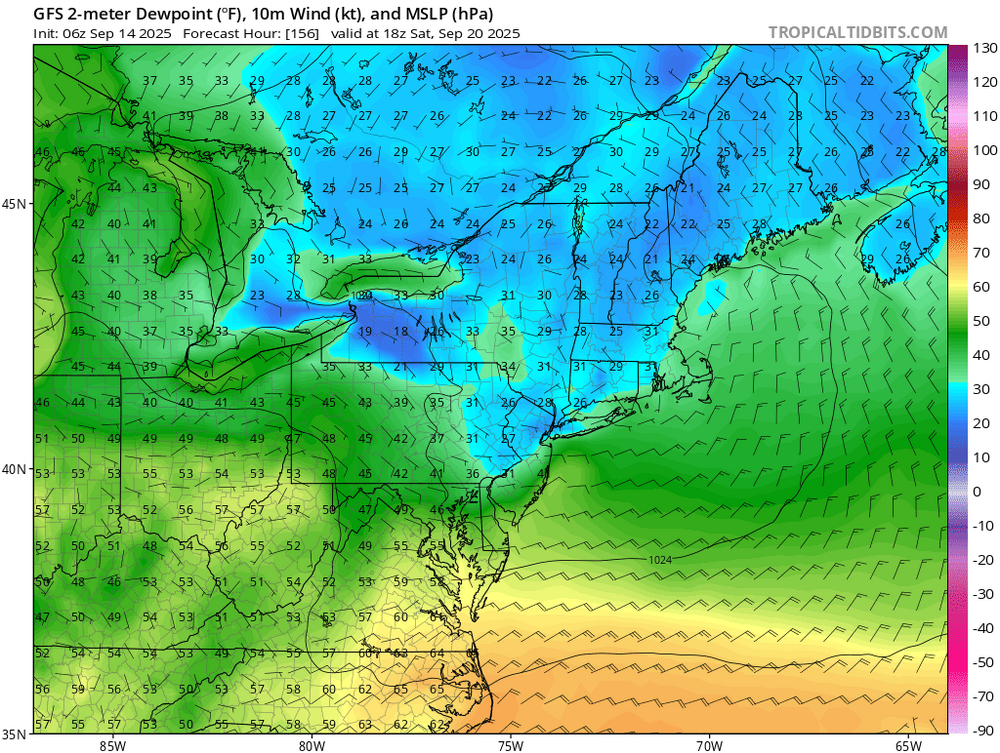
Quick in and out cool shot this weekend…stronger E. Probably frost advisories for parts of ME? But yeah, after that ens/AI are fairly warm. The Op runs bring more cold shots. Not much in the way of precip over the next 10 days here.