
All Activity
- Past hour
-
A break in an overall dry next 7 days here outside some scattered storms/showers on Wed night/ Thu. Rain focused into the Southeast, Southwest mansoon, PAC tropical influence and the much needed deluge over the canadian fires
-
 https://cytocarepharma.shop/# buy misoprostol over the counter
 -
Atlantic vacation: Pacific buzzing
-
Sounds like a CWG forecast.
-
The period from and beyond mid month has been a bit of a back and forth between the warm-hot GFS to now the warm ridegy ECM and the can with Oklahoma ridge center
-
I can't wait for that to appear in a GIS and show up on twitter represented as fact.
-
Records: Highs: EWR: 98 (2018) NYC: 97 (1881) LGA: 96 (2018) JFK: 93 (2023) Lows: EWR: 48 (1938) NYC: 48 (1924) LGA: 53 (1988) JFK: 52 (1963) Historical: 1667: The “dreadful hurricane of 1667” is considered one of the most severe hurricanes ever to strike Virginia. On the first, this same storm was reported in the Lesser Antilles. The hurricane devastated St. Christopher as no other storm had done before. The "great storm" went on to strike the northern Outer Banks of North Carolina and southeastern Virginia. Area crops (including corn and tobacco) were beaten into the ground. 1776: Called the Pointe-à-Pitre hurricane, this storm is one of the deadliest Atlantic hurricanes on record. While the intensity and complete track are unknown, this storm struck Guadeloupe on this day, killing 6,000. 1881 - Forest fires in Michigan and Ontario resulted in 'Yellow Day' in the northeastern U.S. Twenty villages in Michigan burned, and a total of 500 persons were killed. Fires caused 2.3 million dollars in losses near Lake Huron. Candles were needed at the noon hour. (David Ludlum) 1881: Forest fires in “The Thumb” of Michigan and Ontario resulted in “Yellow Day” over the New England states. Twenty villages and over a million acres burned in Michigan. The smoke from these fires caused the sky to appear yellow over several New England cities. Twilight appeared at noon on this day. 1929 - Iowa's earliest snow of record occurred as a few flakes were noted at 9 AM at Alton. (The Weather Channel) 1933: The remnant low of the Treasure Coast Hurricane dumped 10.33" of rain in Charleston, which is the second-highest 24-hour rainfall total on record for the downtown station. The storm produced wind gusts of 51 mph and also spawned a tornado near the city. 1987 - Thunderstorms produced more than seven inches of rain in Georgia. Four persons drowned, and two others suffered injury, as three couples attempted to cross Mills Stone Creek at Echols Mill in their automobile. Smoke from forest fires in California and Oregon spread across Utah into western Colorado. (The National Weather Summary) (Storm Data) 1988 - Unseasonably cool weather prevailed across the north central and northeastern U.S. Thirty cities reported record low temperatures for the date, including Saint Joseph MO with a reading of 38 degrees. A low of 44 degrees at Indianapolis IN was their coolest reading of record for so early in the season. The mercury dipped to 31 degrees at Hibbing MN and Philips WI. (The National Weather Summary) 1989 - An early afternoon thunderstorm produced wind gusts to 104 mph at Winterhaven, FL, flipping over four airplanes, and damaging five others. The high winds also damaged a hangar and three other buildings. A cold front produced strong winds and blowing dust in the Northern High Plains, with gusts to 54 mph reported at Buffalo SD. Powerful Hurricane Gabrielle and strong easterly winds combined to create waves up to ten feet high along the southern half of the Atlantic coast. (The National Weather Summary) (Storm Data) 2003: Hurricane Isabel was first named on September 6th, 2003. It would reach Category 5 status and eventually make landfall in North Carolina as a Category 2. 2017: Category 5 Hurricane Irma affected the US Virgin Island and Puerto Rico. Maximum sustained winds were at 180 mph when the storm hit St. Thomas & St. John. Catastrophic damage was reported over the US Virgin Island & significant damage over Puerto Rico, especially over Culebra.
-

Septorcher 2026 Discussion - Endless Summer
PhiEaglesfan712 replied to Damage In Tolland's topic in New England
I'm here in Cambridge (Assembly Row) for the weekend, and it feels like fall (cool and crisp). High might not even reach 70 today. The high at Logan Airport might be barely over 70. -
Had posted in the other thread EWR matched 2015 with all days in August >80 and was leading in overall 80 degree days. 118 2015, and 117 in 2024. Year Rank Days >= 80 °F 2015 1 118 2024 2 117 2021 3 116 1994 4 114 2016 5 113 1993 5 113 1991 5 113
-
71 / 61 here clouds pushing south and encompassing eastern LI. IN / out of the clouds for a period this morning into early pm then partly sunnay mid 70s to 80 in the warmest locations, eastern sections could see isolated showers around the ULL into Northern ME and and the N-NE flow. Labor day looking mostly sunny mid - upper 70s to 80 or low 80s in the warmest spots inland. Ridge has a 48 hour surge pushing higher heights and 850 MB temps >18c Tue - Thu with Wed and Thu the warmest of the next 7 days and also next shot at some rain Thursday . Overall near to warmer than normal to mid month and warmer beyond there as ridge looks to come east and we'll have to see where it anchors. 9/6 - 9/8 : Near normal 9/9 - 9/11 : Above normal brief surge of warmth 9/12 - 9/15 : Near normal 9/16 - beyond : Above normal (watch ridge position)
-
Late, but you can thank the power outage for that, was working on this when it hit lol. August 2026 numbers- Averaged high was 83.1 degrees vs a normal of 82.7 degrees, a +0.4 degrees above average. Warmest temp was 87.4 degrees on the 15th. Averaged low temp was 61.9 degrees vs a normal of 60.4 degrees, a +1.5 degrees above average. Coolest temp recorded was 48.8 degrees on the 25th. Overall averaged temp was 72.5 degrees vs a normal of 71.6 degrees, a +0.9 degrees above average. Total rainfall for month was 5.29 inches vs a normal of 3.32 inches, a +1.97 inches above average. Wettest day was the 15th with 1.54 inches. There were 13 days with measurable, 4 days with a 'T' and 14 dry days. Highest wind recorded for the month was 53 mph on the 17th, with only 7 days with a speed above 25 mph. No new records for the month. Overall, a wetter than average one with slightly above normal temps with a couple big thunderstorms thrown in.
-

Septorcher 2026 Discussion - Endless Summer
Brewbeer replied to Damage In Tolland's topic in New England
time to correct the thread title -

Septorcher 2026 Discussion - Endless Summer
Damage In Tolland replied to Damage In Tolland's topic in New England
This is what happens with no dews. You get cold pool rains . You wished it, you got it -

Septorcher 2026 Discussion - Endless Summer
wxeyeNH replied to Damage In Tolland's topic in New England
Finally a beneficial soak. .65" last night. -

Septorcher 2026 Discussion - Endless Summer
CT Valley Snowman replied to Damage In Tolland's topic in New England
WTH? I ddn't even look at models for today. I saw mostly sunny for a few days on point and click. Big cookout and b'day party today for my oldest sons. -

Septorcher 2026 Discussion - Endless Summer
kdxken replied to Damage In Tolland's topic in New England
All that's important is Dendrite's bananas get the rain that they need. -
Septorcher 2026 Discussion - Endless Summer
kdxken replied to Damage In Tolland's topic in New England
Since when did Labor Day become memorial Day? Trump might as well cancel 'em.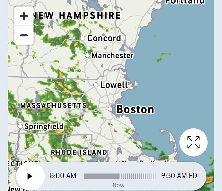
-
Septorcher 2026 Discussion - Endless Summer
kdxken replied to Damage In Tolland's topic in New England
Yesterday was no bargain either. Are we ever going to get that torch? - Today
-
Cytotec 200mcg price: cytotec online : cytotec abortion pill
-
Septorcher 2026 Discussion - Endless Summer
Damage In Tolland replied to Damage In Tolland's topic in New England
Today is ruined. What happened to coc k weekend ? -

Septorcher 2026 Discussion - Endless Summer
tamarack replied to Damage In Tolland's topic in New England
For eastern US it's probably the Cleveland Crusher in Jan 1978. IIRC, that reached low 950s. -
Record number of 80° days away from the sea breeze in NJ through September 5th. Time Series Summary for HARRISON, NJ Most 80° days by September 5th Click column heading to sort ascending, click again to sort descending. 1 2026-09-05 101 0 2 2010-09-05 98 19 3 2015-09-05 97 0 4 2024-09-05 96 0 5 2022-09-05 93 0 Time Series Summary for NEWARK LIBERTY INTL AP, NJ Most 80° days by September 5th Click column heading to sort ascending, click again to sort descending. 1 2026-09-05 104 0 2 2010-09-05 102 0 - 1993-09-05 102 0 - 1991-09-05 102 0 3 1994-09-05 101 0 4 2015-09-05 100 0 Time Series Summary for PHILADELPHIA/MT. HOLLY WFO, NJ Most 80° days by September 5th Click column heading to sort ascending, click again to sort descending. 1 2026-09-05 102 0 2 2024-09-05 99 0 3 2015-09-05 98 0 - 2010-09-05 98 1 - 2008-09-05 98 1 4 2011-09-05 97 0 5 2022-09-05 94 0
-
Have you beat: 0.06”.
-
Really? Don't believe everything you read over in the main Enso thread. Lol The seasonal models will not nail every location. Here's the 9/25 forecast off the Cansips for 12/25-2/26. It has BWI +.5C, so say +1F. What happened at BWI? Every month was BN with an average for the 3 months of -3.7F. So it was too cold in Colorado, and who cares, and too warm where we live.
.thumb.png.948f52756bb30166d9a38b2617d9983d.png)
-

Septorcher 2026 Discussion - Endless Summer
BrianW replied to Damage In Tolland's topic in New England
Hopefully you get swarmed and covered in honeydew.. Spotted lanternflies produce honeydew as a sticky, sugary waste fluid when they feed on plant sap, coating nearby trees and objects. It makes outdoor furniture, decks, and cars sticky, dirty, and hard to clean. Bees also collect it, changing the taste and look of local honey.










.png.9c72afdf23068878c68cc188e28b356e.png)
