All Activity
- Past hour
-
Euro pretty different at 500. Can’t see the sfc yet
-
The GEFS, EPS, EC-AI, and GFS-AI have been trending away from phasing the southern stream energy, leading to an increasingly positive tilted longwave trof. That won't work here for a coastal snowstorm. None of the individual GEFS ensemble members and maybe 1 EPS member support the ICON phasing idea. We need big improvements fast.
-
CFS is quite chilly for February
-
Let’s get this storm to pass us Sunday and see where we go from there.
-
GFS with a 990 100 miles east of where we want it isn’t a bad spot to be 7 days out. AI similar and ICON is a mountains-Virginia major storm. Definitely a signal consolidating for that timeframe. Let’s see if trends continue with regards to phasing and trough placement
-

January 2026 regional war/obs/disco thread
dendrite replied to Baroclinic Zone's topic in New England
I mean I understand how it goes with patterns and probabilities. A great pattern doesn’t always produce. A lousy pattern sometimes does. My problem is when you start using the “strawman” tactics like Mark mentioned to go into business for yourself. It reads like “they don’t know what they’re talking about, but I do” and then proceeds to set himself up in a no-lose scenario. -

January 2026 regional war/obs/disco thread
CoastalWx replied to Baroclinic Zone's topic in New England
Yep -
I think the Debbing should be kept to a minimum until after the weekend at least. sounds like the opportunities are there, and were far too far out to be worrying about specifics.
-
If the GFS is right we’ve got 2 chances at a storm from the 15th-19th, and maybe more after but don’t wanna look too far ahead. If we can just kick this missed/late phase trend we’ve been on for a few years now. Feels like we had a long run of just about everything being amped up qpf bombs and now we’ve swung hard in the other direction.
-
Just trying to keep expectations in check so people aren't disappointed. The globals are really worthless outside Day 5. Ensembles are ok through Day 10. Just nothing screaming snow storm incoming right now. Hopefully that will change over the next week...
-
January 2026 regional war/obs/disco thread
CoastalWx replied to Baroclinic Zone's topic in New England
I don’t have the energy to do a nice illustration of this, but go on the website like tropical tidbits, pick the North America sector, and look at the 500 MB height anomalies on the GEFS. You’ll see a trough over the Bering Sea, a ridge sort of positively tilted from California up to the Western Canadian prairies, and a trough over the Midwest that looks like it should do something here. Now go to hr 174. Notice that Bering sea trough sends a s/w into the nrn plains of the US while the east coast trough almost tries to sharpen to make things interesting. However, that nrn plains s/w acts as a kicker and does not allow it to sharpen to bring a low up the coast. But here is the fun part, that s/w digs enough the of course the ridge retros into AK just enough to sharpen that and bring a more messier system into the northeast. That’s been our luck. Go forward through day 8 and you’ll see. Now the reason why I’m saying it’s a non-0 chance is because it wouldn’t take much to bring that storm up the coast and at least graze us with a high-end advisory snow… But it just goes back to what I’ve been saying there’s just too much crap interfering in this flow. -
Too much energy flying around. With a low in the great lakes, nothing is coming up the coast.
-
If the southern US ULL doesn't at least partly phase into the longwave trof, Thurs/Fri next week will almost certainly end up with a positively tilted trof folding onto itself and the baroclinic zone well offshore as currently modeled by the GFS and ECM. The ICON is the only model that tracks the northern stream shortwave far enough west to get the ULL on the downstream (right) side of the longwave trof, allowing phasing. There are no individual GFS/ECM ensembles members that support the ICON, which is why I think it's wrong about this feature.
-
I appreciate your suggestion, but No, I won't ignore them. I fully understand that they are supposed to be more accurate than the deterministic models because of more data input across various parameters. A higher skill score should be achieved, especially for complex systems or longer term considerations. I will develop a comparison chart for ECM/EPS and GFS and GFS ens. Saturdays rain will be a good first comparison.
-
lol…you two bringing the Eeyore? Surprise!
-
Kicker is very strong and south
-

January 2026 regional war/obs/disco thread
mahk_webstah replied to Baroclinic Zone's topic in New England
I think the guy is just saying that he thinks the pattern is going to be more conducive to East Coast storms. We’ll see if that’s true or not. -

January 2026 regional war/obs/disco thread
40/70 Benchmark replied to Baroclinic Zone's topic in New England
This looks like last January failed phase in some respects attempts...not identical pattern. https://easternmassweather.blogspot.com/2025/02/thursday-storm-threat-by-wayside-as.html -
January 2026 regional war/obs/disco thread
mahk_webstah replied to Baroclinic Zone's topic in New England
Yes, that is my main concern with this guy. Not his idea, what’s the next couple of weeks will render verdict for. I don’t like the style of writing where someone creates a false strawman and then disagrees with it. That’s incredibly common these days, particularly in our political discourse. But everything is political now. -
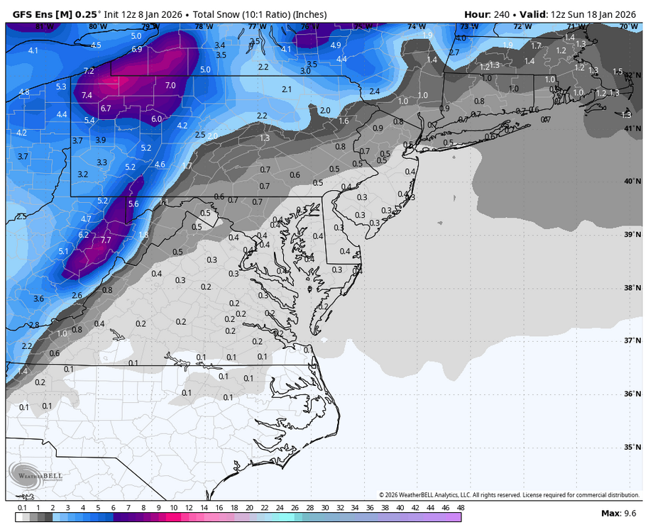
WB 12Z GEFS has nothing for next 10 days.
-
EURO AI nothing for next week either....
-
January 2026 regional war/obs/disco thread
CoastalWx replied to Baroclinic Zone's topic in New England
Love when people do that. The ole CYA. And then if the outer banks get snow, they’ll claim victory because that’s part of the “East Coast.” -

Central PA Winter 25/26 Discussion and Obs
pasnownut replied to MAG5035's topic in Upstate New York/Pennsylvania
Yep. Looks like we'll be transitioning to a busy time and while the chances look to be there, its going to be really into short term till the subtleties get sorted out, as that will make notable difference in backyard, and on perty snow maps. -
When isn’t it?
-
As long as it’s active that’s all I care. The weather has been a snorefest overall.


