All Activity
- Past hour
-

12/12: The little Friday clipper that could? Or won't.
WesternFringe replied to dailylurker's topic in Mid Atlantic
I will take the Euro/NAM combo for an inch of snow on top of our snowpack. I will take pictures for you! -
New York City finished December 1-10 with a mean temperature of 34.1F (1.2C). That was the coldest first 10 days of December since 2007 and sixth coldest since 2000. A quick look at the guidance shows that a light snow event (probably 1"-3") across the New York City area is likely on Sunday. Given how snow events have been challenging to come by in recent years, to some it might seem like a big event. Even the previously bone-dry NBM shows 0.12" QPF.
-

December 2025 Short/Medium Range Forecast Thread
louise.caison233 replied to John1122's topic in Tennessee Valley
The pattern looks messy, but there’s still time for shifts. One good storm can flip the mood fast, so I’m not giving up hope yet. - Today
-
Doesn’t get much better than the 0z euro / cmc combo for the I-95 metro corridor
-

E PA/NJ/DE Winter 2025-26 Obs/Discussion
RedSky replied to LVblizzard's topic in Philadelphia Region
Euro 1-3" north to south All guidance shifting south -

Central PA Winter 25/26 Discussion and Obs
MAG5035 replied to MAG5035's topic in Upstate New York/Pennsylvania
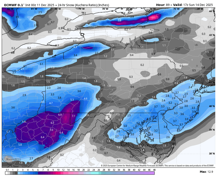
It’s even more pronounced on the other globals. Especially on the GFS, which doesn’t have a snowflake make it east of I-99. GFS is probably on the far end of that side of the spectrum (and a bit further south with the wave as well), but that shadow off the Alleghenies is probably going to be a thing with this setup. The wave isn’t all that strong and doesn’t have much moisture to work with. Most modeling doesn’t have a closed surface low until this hits the coast, which is why the second snow swath shows up in SE PA and the DC to NYC 95 corridor. Otherwise the wave is running on a westerly flow, which downslopes off the east side of the Alleghenies. The 0z NAM had a more pronounced shortwave as it passes under PA, which made that about the only model to not have the shadow. Other modelling tonight 3z NBM (National Blend of Models) vs NBM v5. The v5 is an updated version of the NBM being tested ahead of being deployed April 2026. 0z Euro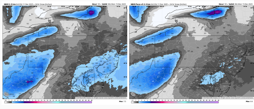
-

Minor snow possible sunday 12/14/25
NEG NAO replied to WeatherGeek2025's topic in New York City Metro
Widespread Snowfall Region wide up to 4 inches BUT these snowfall totals can change in either direction by Sunday........... -

Minor snow possible sunday 12/14/25
SHELEG replied to WeatherGeek2025's topic in New York City Metro
Anyone see the Latest Euro? -
Maybe the most negative steady trend today is both Euro-AIFS and EPS incrementally pulling away for 4 cycles since 6z today
-
I think we are out of luck on that. Agreed the trough just is not favorable for much amplification sooner. 30:1 ratios could help. Lol
-
the angle of the trough also kinda sucks. it barely gets its shit together in time so we get a neutral tilt but if we want it negative then we'd need it to slow down and dive SW
-
I would like it to get it's act together a lot quicker.. I would take anything though. We have wasted way too much cold.
-

12/12: The little Friday clipper that could? Or won't.
Jebman replied to dailylurker's topic in Mid Atlantic
There ain't gonnabe NO torchmas. Its gonnabe a frigidmas and a very snowmas and all your backs will be soremas from too much diggingmas. -
Maybe I'll take a stab at a thread.
-
0z EC: can see the worse outcome well before... at 72h 0z Sunday the PV center ticked slightly east over Lake Huron instead of Lake Michigan... that slight tick is enough to smush heights downstream and keep the trough more positive... Models are vacillating between SNE graze vs. 1-3/2-5... (and though hard to explain, it does strangely seem to correlate with 6z/18z vs. 0z/12z). Probably won't lock in for another 24 hours or so. I'm still favoring at least advisory in southeast areas.
-

December 2025 Short/Medium Range Forecast Thread
John1122 replied to John1122's topic in Tennessee Valley
Looks like some decent snow showers moving across SE Kentucky, as with every single event in December, I'm likely too far west unless radar just isn't picking up anything NW of me, but basically SE Kentucky, Claiborne and points East may be in good shape if the Cumberlands don't dry those out. -
Euro making friends
-
I'm glad I stayed up. IMO excellent 0z suite. CMC and Euro trended south and GFS trended north. Euro AI also higher totals for everybody except @TSSN+.
-
Damn, that’s perfect. Please stay right there.
-
Pretty much, yeah. I just looked up snowfall in the whole region from 2017-2018 until this past winter - and Baltimore is, as far as I can tell, basically the only place in the Mid Atlantic to have 0 years where we didn't have at least 100% of average annual snowfall. I won't derail this thread by posting a bunch of maps, but maybe tomorrow I'll post them in banter.
-
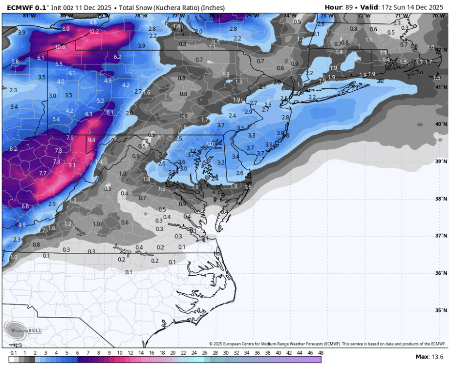
Euro is money DC-Balt. 3-4”
-
0z Euro follows suit with the CMC by going more south; I think DC/Balt would like it. Also has more QPF
-

December 2025 regional war/obs/disco thread
Torch Tiger replied to Torch Tiger's topic in New England
it's way out there, so the timing is probably off, but it's probably gonna happen. Big changes. That doesn't necessarily mean "torch", as Dendrite and others pointed out the past few days. The big relaxation signal is not going away just yet. Also, not a bad thing if you're in the mood to roll the dice/shake it up (Sorry NNE? or not ).thumb.png.4b6e21d17280d46b8f49f3d001632c9c.png)
-
Euro cut back even down here. Looking like 1-3 here .
-
You guys must be close. How much would you charge?.


.png.f66709a1eca3c76da21639cda5f2823e.png)
