All Activity
- Past hour
-

2025-2026 ENSO
brooklynwx99 replied to 40/70 Benchmark's topic in Weather Forecasting and Discussion
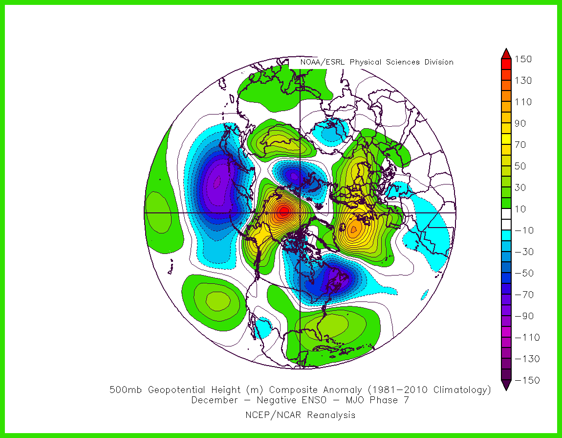
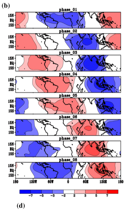
this is a pretty obvious P8 signal. there is very little, if any forcing showing up on the EPS over the Maritime Continent
-

December 2025 Short/Medium Range Forecast Thread
Carvers Gap replied to John1122's topic in Tennessee Valley
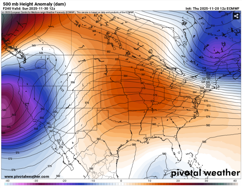
There should be some wild model swings, but we are gonna have to let the dust settle after the past 24 hours of models flip flopping. They may go back cold like the AIFS. The may trend much warmer if that cutoff is really. So things to watch? Does that cutoff leave the SW or does it stall out? If it cuts of and stalls -> SER here. If it ejects -> big time cutter w/ cold following. Until that gets worked out, just guess work. -
December 2025 Short/Medium Range Forecast Thread
Carvers Gap replied to John1122's topic in Tennessee Valley
I had a ton of posts up this morning, but as I dug through modeling one thing was clear...ensembles and their deterministic runs were signaling a big warm-up after the Thanksgiving cold. How long does it last? IDK. In a rare move, I deleted all of those posts. Why? When modeling moves in unison towards warm...something is afoot and it usually isn't cold. The MJO argues for a very sharp cold trend in LR modeling which is not present yet. Sometimes, modeling doesn't "see" the MJO until about d10-12. The problem is the MJO really doesn't drive winter weather until Jan/Feb...and maybe late December. Right now, everything is very volatile after d10. Extreme cold is still on the table but kicked to December 8th or later IMHO. Outside of experienced mets, nobody knows what is coming w/ that cutoff low and SSW projected. An amplified pattern appears likely with wild swings between cold and warm. -
There could be some MJO 7 elements in the mix for early December. But the convection lingering near the Maritime Continent may not translate into a purely 7 composite. So with more of a split forcing pattern perhaps a variation on the phase 7 theme. I agree that the phase 8s have been a big challenge since January 2022. Even when the RMM charts indicated a phase 8 verifying, lingering phase 4-6 convection didn’t lead to the desired outcome. The record SST warmth near the Maritime Continent had been altering the convective forcing and sensible weather patterns.
-
December 2025 Short/Medium Range Forecast Thread
Carvers Gap replied to John1122's topic in Tennessee Valley
Yeah, sure bet SSW is wrecking havoc on what looked like a good pattern without it. We have seen this many times during the past winters -> good pattern at range gets wrecked by an SSW. The only positive with an SSW is that it could put very cold air over the eastern US. My guess is that it dumps into western Canada and Montana and SLOWLY oozes west over a period of 1-2 weeks and modifies greatly. The big thorn in the medium to LR is a cutoff low over the SW which dives into Baja to start December. Until modeling works that out, the EC wx pattern is probably wrong. If that is real, that will pump a monster SER over the SE. There is ample precedence for this. Sometimes modeling is correct. Sometimes it is feedback. The 12z Euro goes absolutely bonkers with it. It creates a chinook over the southwest which pumps record heat into the souther half of the United States - like summer time heat for early December. I have looked at major ensembles today at 12z, and they are just wrecked. No other way to put it. What do I mean by that? Consistency is just shredded. In "general," the can has been kicked by a week at least. The Weeklies caught this first. I may just start using the Weeklies...LOL. However, the MJO and ensembles definitely foretell of a huge trough over eastern Canada by d14-16. Problem? The SER is flexed big time, and that standing wave is gonna have to get knocked down w/ several cold fronts. It cuts the bottom out of the trough. Seasonable cold looks like the outcome if today's iteration is correct, and it probably isn't. Let's hope the EURO AIFS and GEPS are correct, and they could be. For now, I am kind of watching the timeframe just after Thanksgiving. I wouldn't be surprised to see a NW flow event or storm pop w/ that. 500 vort maps are not missing by much when it comes to both streams. Overall, I think the cold is coming, but any time models start "can kicking" in unison, be very careful about expectations. I wouldn't be surprised to see a record cold outbreak. I wouldn't be surprised to see it completely vanish at our latitude. My gut says extreme cold is coming for the Mountain West. Why do I think this? 15 years of watching it do that 90% of the time. It will make its way here probably between Dec 10-25. Then we warm up. I suspect the cold reloads quickly and we see another bout to start the new year. While I am bearish now for early December, I still think we see a reloading cold pattern which is prob the result of the SSW. But for now, I am "out" on early December extremed cold. I think it will be seasonable to AN for week one, transition week 2, and maybe a cold week 3 before warming back up...and reload. -
Well, yeah. It would take a little time to imprint on the circulation. Perhaps it's only one run but it was the same one. I would have expected to see some differences on the model if there were interference with the signal. Totally agree with you regarding phase 8. We'll definitely want to see the suppressed phase center itself over 120E to achieve the proper effectiveness IMO.
-

December 2025 Short/Medium Range Forecast Thread
Daniel Boone replied to John1122's topic in Tennessee Valley
Models usually get wonky when dealing with Stratosphereic Warming. -

December 2025 Short/Medium Range Forecast Thread
jaxjagman replied to John1122's topic in Tennessee Valley
See what it shows this afternoon,shouild update in about a hr and a half -
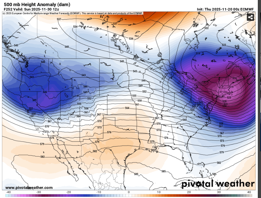
Close to record heat the 4th if that were to materialize. You can see huge motherlode of cold in Canada. That'll drive down on the heels of a major cutter. Then a boundary should ultimately setup somewhere along the Apps overall until the MJO goes toward late Ph 7. or the NAO goes negative. Either will drop that Boundary furthe SE. IF both coincide then the upper SE should see Snow Opportunities. If MJO ph.8 coincides with Blocking, fun and games for the deep South likely, imo.
-

November 2025 general discussions and probable topic derailings ...
tamarack replied to Typhoon Tip's topic in New England
The washtub had a bit over 1" ice when I dumped it yesterday (before the ice would get thick enough to split the seams, like our last one), though some was gray ice from Sunday's snow. The old stock pond probably has close to 2" after this morning. -

December 2025 Short/Medium Range Forecast Thread
Met1985 replied to John1122's topic in Tennessee Valley
Yeah yesterday didn't look as good but I mean it freaking changes daily. But even a weakened state helps tremendously. -
People just expect too much accuracy from model guidance, especially past day 10. The model doesn't know it's showing a "pattern change." That's just human interpretation, which is also subjective and biased. When models are inevitably less accurate in the long-range than we wish, particularly after we've identified a perceived regional "pattern change," we feel like the model failed or delayed it. But the failing is our false interpretation and unrealistic expectation. We really should stop anthropomorphizing weather models.
-
December 2025 Short/Medium Range Forecast Thread
jaxjagman replied to John1122's topic in Tennessee Valley
EPS seems to be having a rough time to have such volatile swings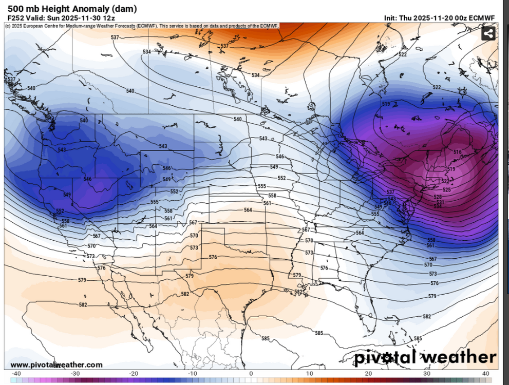
-
That is just a one day snapshot from a 360 hr run. A few days before that it has a different look. Convection lingering near the Maritime Continent will tend to stall the movement toward a more classic phase 8 which was mentioned in the post that I was replying to.
-
December 2025 Short/Medium Range Forecast Thread
Daniel Boone replied to John1122's topic in Tennessee Valley
Yeah, yesterday backed off and today gained momentum. Models for you. -

Central PA Fall Discussions and Obs
Voyager replied to ChescoWx's topic in Upstate New York/Pennsylvania
That's as good a day as any for a snowstorm for this truck driver. I'm off on Black Friday, and won't go back to work until 12/3, so let it rip...lol -

November 2025 general discussions and probable topic derailings ...
Typhoon Tip replied to Typhoon Tip's topic in New England
That's an ugly Euro run... It's also a fantastic continuity break for a span of time outside of D7 so meh. But it's attempting a -EPO with zero discernible pattern implications for S of 40 N across the continent. that'd be a neat trick. -
Wow, pretty much nothing jives up at all, haha. Wild
-
I don't know. That doesn't look very significant. Where is the said difference? This is that same eps run as posted and these look basically like a carbon copy, to me.
.png.9346241d3750ced6a47649ca3937de59.png)

-
December 2025 Short/Medium Range Forecast Thread
jaxjagman replied to John1122's topic in Tennessee Valley
The map he showed was the OZ,i assume early this morning,mine was yesterday afternoon,so it must have changed between - Today
-
December 2025 Short/Medium Range Forecast Thread
jaxjagman replied to John1122's topic in Tennessee Valley
I seen that this morning,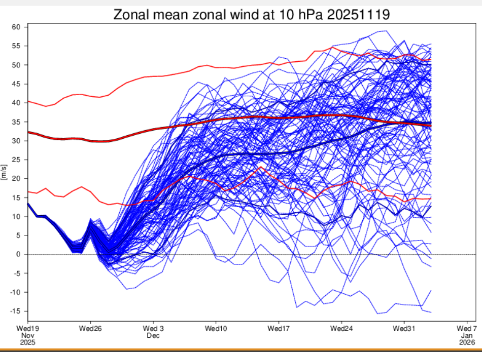
-
I'd honestly prefer to get deeper into December.
-
are we still interested about stratwarm and potential ramifications mid and late Dec?
-
The affinity and tendency for ULLs to traverse the entire length of CA is going to be a recurring problem (as others have stated). That makes it difficult to break free of the warm/wet -- dry/cold oscillations.
-
41 with drizzle.