All Activity
- Past hour
-

Central PA Winter 25/26 Discussion and Obs
Voyager replied to MAG5035's topic in Upstate New York/Pennsylvania
Probably not a bad idea... I've got to say, I've always been a go big or go home snow person. This time even moreso. We're down to barely a 2" snowpack, and the rain we had Wednesday afternoon/evening washed most of the salt residue off the roads. At this point, if we can't get 8-12+, then I'd prefer the NAM's no snow showing. -
.thumb.jpg.6a4895b2a43f87359e4e7d04a6fa0d14.jpg)
Central PA Winter 25/26 Discussion and Obs
Yardstickgozinya replied to MAG5035's topic in Upstate New York/Pennsylvania
There hasn't been any lightning strikes detected for quite a while, but it looks like a lot of the sub is getting some decent rain atm.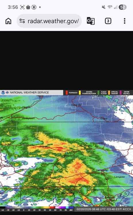
-

Central PA Winter 25/26 Discussion and Obs
Jns2183 replied to MAG5035's topic in Upstate New York/Pennsylvania
Id follow my rule with this one of not taking any model and forecast seriously till 5pm Saturday Sent from my SM-S731U using Tapatalk -
Central PA Winter 25/26 Discussion and Obs
Jns2183 replied to MAG5035's topic in Upstate New York/Pennsylvania
This afternoon the nam barely had the low to the NC/GA border Sent from my SM-S731U using Tapatalk -
Central PA Winter 25/26 Discussion and Obs
Voyager replied to MAG5035's topic in Upstate New York/Pennsylvania
It tried, but then moved east-northeast off of Virginia Beach. -
Central PA Winter 25/26 Discussion and Obs
Jns2183 replied to MAG5035's topic in Upstate New York/Pennsylvania
Haha we have less than an inch forecast. Im not really going to worry about forcast amounts till Saturday evening, which is the earliest I expect accurate forecasts for this seductive teaser storm. I'm much more enamoured and enjoying the variance show the weather models are putting on. It really started to get boring a couple years ago when it seemed like everything was locked in with storms before they even got in NAM range. This hobby is alot more enjoyable when the possibility of monumental busts within the final 48 hours have a bit of credibility. I'll take a couple times of having the rugged pulled out from under me the last second for just a chance to experience the magic of going to bed expecting an inch and waking up at dawn to 6", thunder and a white out and seeing the shell shocked local weather men like the one experience I had as a kid. Sent from my SM-S731U using Tapatalk -

“Cory’s in NYC! Let’s HECS!” Feb. 22-24 Disco
CPcantmeasuresnow replied to TheSnowman's topic in New England
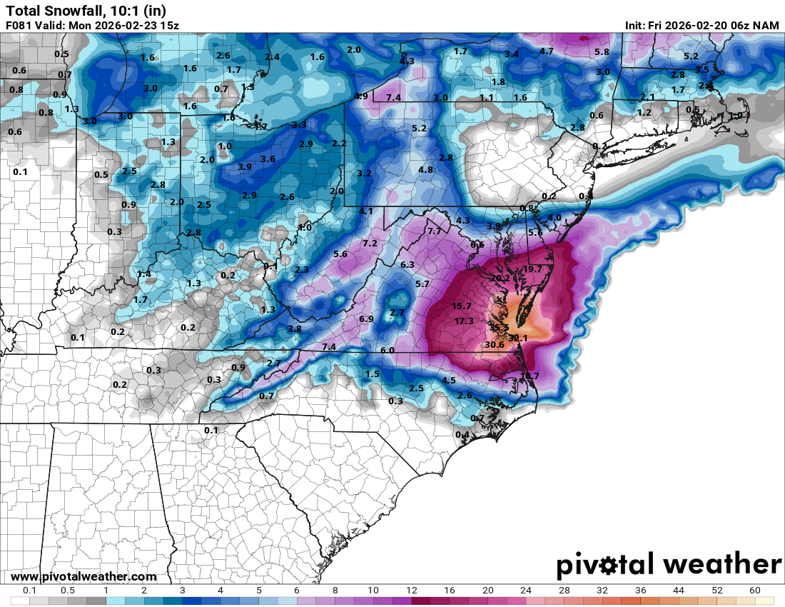
32 inches in Virginia Beach ? Yeah I'm not going to take that run serious. It will however keep me up for at least another hour. -
NAM looking like a middle of the road outcome between the gfs and euro (coastal wise) at first glance?
-
Love me fantasy NAM storms.
-
Hey-we all know how bad the Tidewater’s been lacking and how much they need another one while we get cirrus.
-
Mid Atlantic has been getting more coastals than us up here.
-
If that pans out i quit.
-

Feb 22nd/23rd "There's no way..." Storm Thread
Terrapinwx replied to Maestrobjwa's topic in Mid Atlantic
Stalls too far south to get a GFS result, but gets solid coastal action into the cities . -

Central PA Winter 25/26 Discussion and Obs
MJO812 replied to MAG5035's topic in Upstate New York/Pennsylvania
Nam was further west but it couldn't climb -
-

Feb 22nd/23rd "There's no way..." Storm Thread
yuki neko replied to Maestrobjwa's topic in Mid Atlantic
6z NAM looks much better than 0z More phasing of the ns vort -
Central PA Winter 25/26 Discussion and Obs
Voyager replied to MAG5035's topic in Upstate New York/Pennsylvania
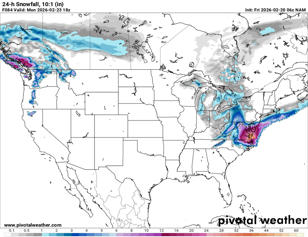
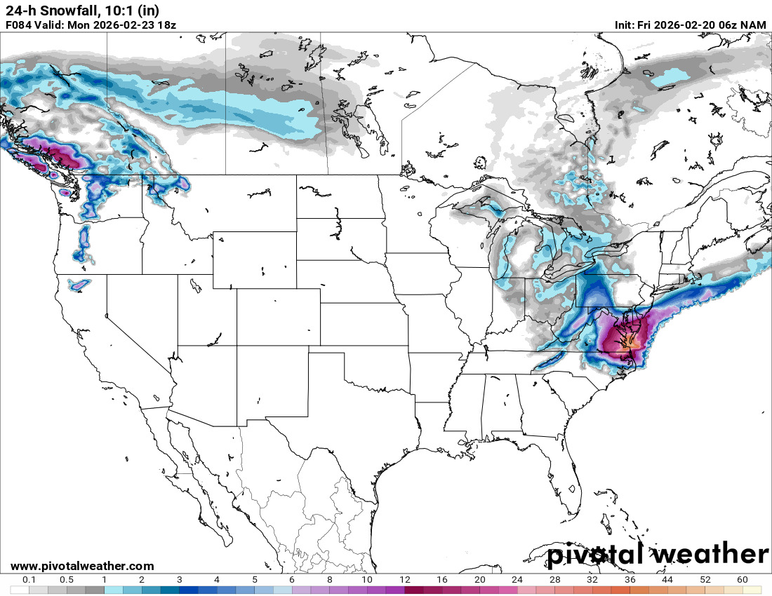
And then the 6z NAM totally shuts out the eastern half of PA. No snow, no precipitation. Absolutely nothing north of the M/D line. -

-
Central PA Winter 25/26 Discussion and Obs
Jns2183 replied to MAG5035's topic in Upstate New York/Pennsylvania
Forgot one Sent from my SM-S731U using Tapatalk.thumb.jpg.6256754873625f18787754a3e89a0028.jpg)
-
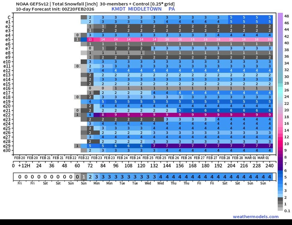
Central PA Winter 25/26 Discussion and Obs
Jns2183 replied to MAG5035's topic in Upstate New York/Pennsylvania
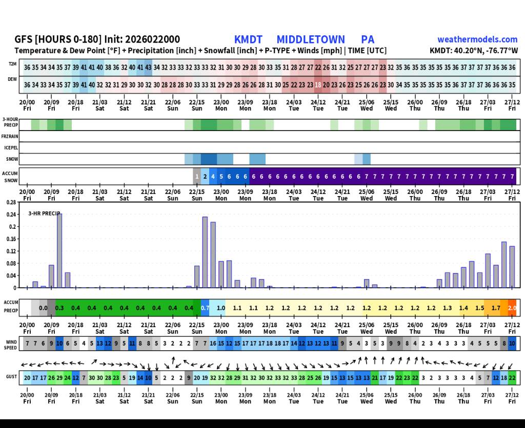
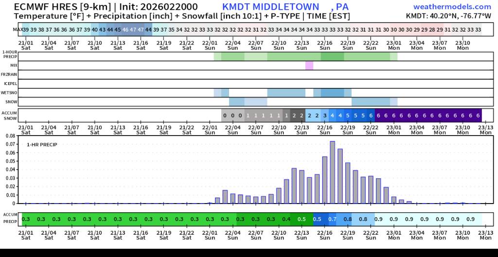
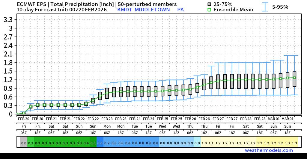
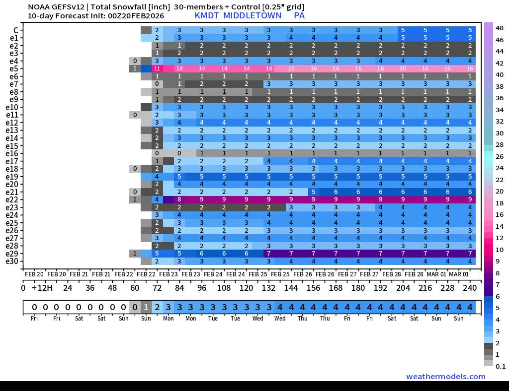
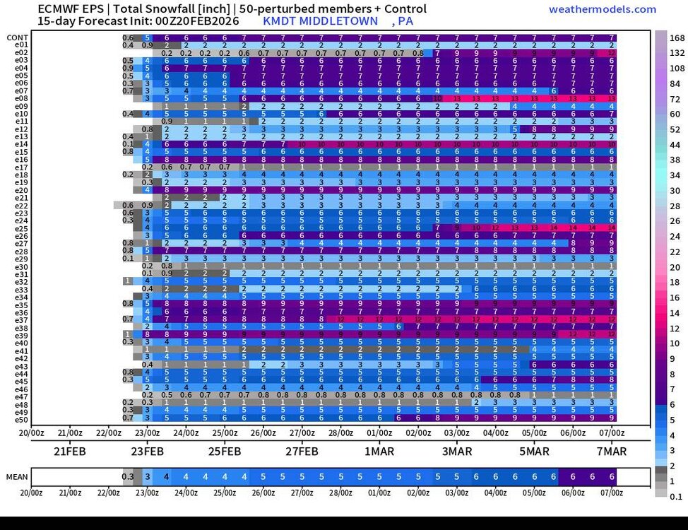
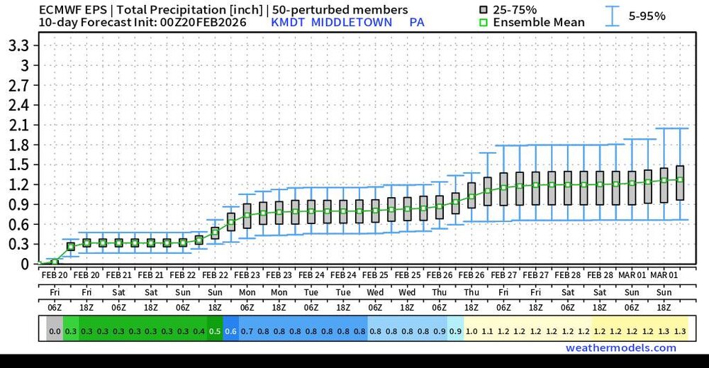
I fell in love with this company city charts so I treated myself to a one month subscription. Enjoy the granular detail. Especially the ensemble ones. Sent from my SM-S731U using Tapatalk

-
6z NAM just dumped 30"+ on SE VA. Lol
-

“Cory’s in NYC! Let’s HECS!” Feb. 22-24 Disco
The 4 Seasons replied to TheSnowman's topic in New England
I didn't think anyone would think that I took that seriously. Yeah it's obviously an error, grids are all fucked up in BOX. Anyway.. -

Pittsburgh/Western PA WINTER ‘25/‘26
north pgh replied to Burghblizz's topic in Upstate New York/Pennsylvania
It woke me up. It gets me anxious for spring storms -

“Cory’s in NYC! Let’s HECS!” Feb. 22-24 Disco
ineedsnow replied to TheSnowman's topic in New England
Pretty sure that's wrong lol look at the temps -
Central PA Winter 25/26 Discussion and Obs
Voyager replied to MAG5035's topic in Upstate New York/Pennsylvania
Not according to CTP. They put out first numbers in my point and click... Sunday Snow showers. High near 35. Chance of precipitation is 80%. New snow accumulation of 3 to 5 inches possible.


.jpg.8e6fb6307a4e6134a491a0e70710bdec.jpg)