All Activity
- Past hour
-
While the pattern is warming up from late May, it’s still staying wet. So even though the temperatures are above average, the high end potential is limited. Would need to see things really dry out for major mid 90s to around 100° as the month progresses.
-
@Damage In Tolland
-
Quintessential June morning. 66° and the last of the trees are blooming. Hard to beat a nice June day.
.jpg.d7746567b5d7a05625ab8f079052f6f4.jpg)
-
I started to measure at age 9 back in 87/88. My first year was incomplete, so I used Rutgers data since the college was partly in my town. My older brother was big into weather and even went to college for it, so we were both little snow weenies from an early age. My first 4 seasons measuring all pretty much stunk, 12.5, 17, 20 and 15". Once I was married and moved, I only moved about 14 miles west, so the data is similar. Though, if I had moved to where I am now, Boxing Day here was only 7" and 14 miles east where I was was 24". I would have flipped out! But that goes to show you, using one location and using blanket statements like the whole area is in a new climate is just not the way to go all the time and doesn't tell the whole story.
-
another comfortably cool day low dewpoint feel nice...i am still wearing my hoodie..
-
Who lives there?
-
52 was my overnight low, already up to 68 at 9:15am. MU already honking about severe weather at the end of the week.
-
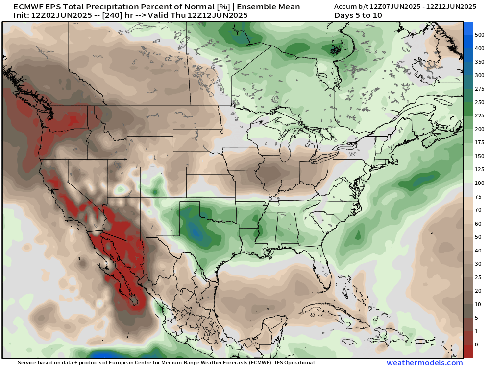
WPC is still pretty good on precip over the next 7 days. GFS backed off. The Euro still pretty wet.
-
HIE reported 32 this morning so you're not alone. IZG had 36 and we were about the same. Last 30s until September?
-
Heh 25 deg rise and it's only 9 and change. impressive 45 to 70
-
46 this morning.
-
I think this also happened to you in 2010-11 for the Boxing Day event.
-
Yes the high end el ninos create these jumps that accentuate its effects even more. It makes me wonder if these high end el ninos are increasing in frequency too.
-
1997: It was a chilly day in the East. The high temperature at Philadelphia International Airport was only 59 degrees, tying a record-low maximum for the date set back in 1881. The temperature at Middletown, Pennsylvania rose to 58 degrees, breaking the record-low maximum for the date of 59 degrees set back in 1915. Washington, DC only reached 58 degrees, breaking the old record-low maximum of 59 set back in 1915. Central Park in New York City only reached 61 degrees. 2002: An impressive heat burst at Amarillo, TX caused the temperature to jump to 90° at 3:21 am. The heat burst was accompanied by winds of 55 mph. (Ref. Wilson Wx. History) wow I didn't know or remember this about 1997. What was our low that morning? Wild, 1915 had one of our largest late season snowfalls ever in the month of April. Heat bursts are one thing Texas is famous for, Kopperl Texas had a severe one when the temperature rose to 140 degrees and trees and even wooden doors were burned!
-
That should be par for you in early June.
-
correct, this is more of a typical early summer pattern.
-
This pattern is nothing like May though, the temperatures are going to be warmer (mid to upper 70s) as opposed to the horror we had in May. This is just a wet humid summery pattern with showers from time to time.
-
Monday/Tue next week then trough into the GL/MW overall beyond there. Euro similar to the Canadian (not sure why its not updating yet). Week of 15 looks warmer as of now with ridging and more heat from the SW building east, perhaps the Western Atlantic Ridge back west later on in the month as well. No sustained heat on the horizon but what has become more typical above normal overall with potentially routine storms/showers with the trough to our west.
-
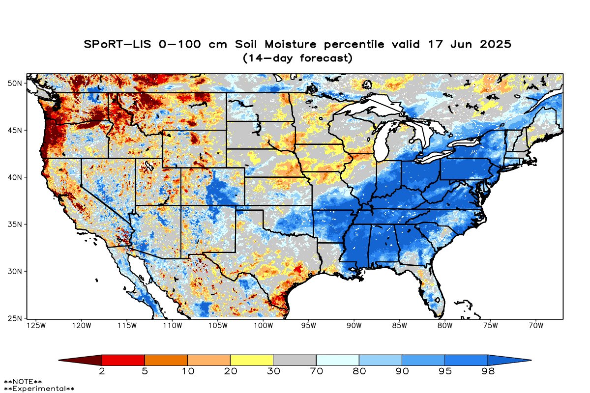
Update on soil moisture. Much improved , seems lower DE and Western zones not as robust as the general area, but not horrible.

-
 Johnjaxea joined the community
 -
No clear signal, but some rainfall seems possible
-
Warmest day since May 30th and first 80s (for most) since May 17th today. Also moving into a period + departures for a majority of the next 2 weeks (overall) .
-
I'm curious, at what level are the winds bringing the smoke in? According to the models we should be in southwest flow at 500 with this thunderstorm setup ahead of the incoming cold front.
-

2025-2026 ENSO
40/70 Benchmark replied to 40/70 Benchmark's topic in Weather Forecasting and Discussion
I don't think strong El Ninos are the catalyst for global warming, rather I just think global warming manifests most prominetly during high-end warm ENSO events. -
2025-2026 ENSO
40/70 Benchmark replied to 40/70 Benchmark's topic in Weather Forecasting and Discussion
PD II was just bad luck...I was in a subsidence area of around a foot. -
yeeee up