All Activity
- Past hour
-
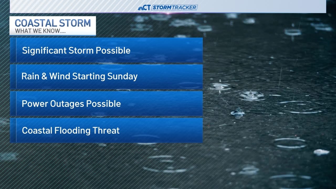
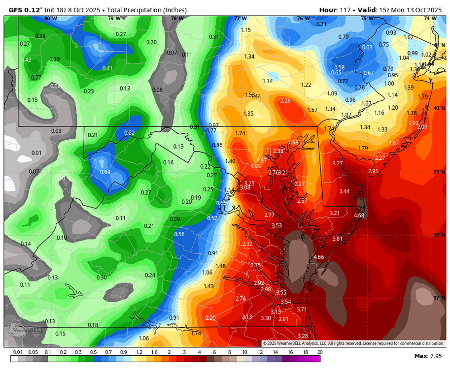
Lots of rain on gfs and especially euro around here.
-
WB 18Z GFS ticked west.
-
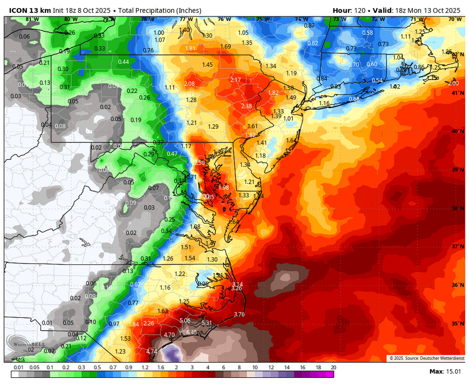
WB 18Z ICON does not phase and is less intense/ more offshore.
-
Oh yeah, seasonal maps are almost always warm at the surface. I generally just look at 500 maps and source regions - even for weeklies. The Euro seasonal and weeklies(mean) almost never see cold at range. Now, the one thing that does work is to look at the control surface and/or 850 temps on the Euro Weeklies - that gives a look under the hood so to speak. The seasonal CFSv2 looked good today. I almost posted it, but it will likely change tomorrow. The CANSIPS has shown some skill at range w/ its 500 and temps maps...but only the November run has been accurate, though October can provide some hints.
-
18z GFS a bit weaker and further south.. still big impacts though
-
flooding is going to be bad on the coast
-
The one in my Corolla has been stuck on for over a year. I check the tires with a pressure gauge periodically and they are always close to spec, if one is low I pump it up but the light never turns off.
-
Neutrals are a complete dice roll. 2013-2015 were rather neutral, but things broke our way more times than not.
-
Yeah they generally aren't good. Best case outside of a fluke is an avg snowfall winter.
-
I'll take my chances with a torch in September and then a couple coastals in October.
-
.54 here to green up the grass.
-
28° here tomorrow night? I wonder what we have left in the oil tank??
-
I mean considering that we just finished a torch…
-
The last neutral was a snowless torch fest.
-
-
Models have that weird pressure pattern over CT again and associated increase/decrease of LLJ.
-

Spooky Season (October Disco Thread)
ineedsnow replied to Prismshine Productions's topic in New England
Tonight Mostly clear, with a low around 34. North wind 7 to 9 mph, with gusts as high as 20 mph. Thursday Sunny, with a high near 54. North wind 8 to 11 mph, with gusts as high as 21 mph. Thursday Night Widespread frost, mainly after midnight. Otherwise, clear, with a low around 27. North wind around 5 mph becoming calm in the evening -
Spooky Season (October Disco Thread)
ineedsnow replied to Prismshine Productions's topic in New England
I know were past the date or whatever to get a freeze warning but what kind of map is this.png.b6070ae692f88e2f60789c1d83fb7fc9.png)
-
who cares we drive to the beach!
-
it's very likely his only analog is 2013-14
-
We need to find those Archives. I'm pretty sure they did. I think they showed a Canonical Nina 500 look as well as Temp. Profile.
-
JB nailed Sandy first, just ask him.
- Today
-
Pretty bullish considering he is predicting an ENSO neutral winter. Plenty of uncertainty wrt snowfall for the greater DC area in La Nada winters, but pretty sure historically it tends be average to below average without digging into it further.
-
Let's hope this is a precursor to many of these as we get into winter.
-
Hammer says it’s finally our time .We damage .