All Activity
- Past hour
-
Picked up 0.17" overnight here. It was 55.1 degrees at 7 am, which was the low for the period, not a new 'warm minimum', that still stands from 2005's 58 degree reading. High was 65.6 degrees, also not near a record high as the 72 from 2005 remains. Windy overnight, currently WNW at 16 gusting to 29 mph at 8 am and 53.7/44.7 under mostly cloudy skies.
-

Central PA Fall Discussions and Obs
mahantango#1 replied to ChescoWx's topic in Upstate New York/Pennsylvania
If they are in the river, Hopefully Your good neighbor Canderson downstream from you could retrieve them for you. -
I was hoping this would be the year for a 6 inch plus event but I am not so optimistic now.
-
This is my regular pop-in to say that our area is among the least windy places in the US.
-
Where were these readings actually taken because obviously there were no airports for a very long time.
-
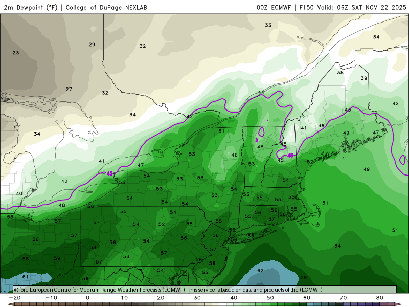
NYC and LGA may have to wait until December for their first freeze with the big trough taking up residence next few weeks out West. New York City... Central Park, NY Ptcldy Ptcldy Ptcldy Ptcldy Mocldy Mocldy Ptcldy /54 36/45 34/48 36/49 39/52 45/58 49/58 /10 10/00 00/00 20/20 20/20 40/40 40/40 LaGuardia Airport, NY Ptcldy Ptcldy Sunny Ptcldy Mocldy Mocldy Ptcldy /55 37/45 35/48 37/49 40/51 45/57 49/58 /10 10/00 00/00 20/20 20/20 30/40 40/40
-
 Sigh
Sigh -
56 / 43 partly cloudy and had 0.09 of rain - heavier showers/storms to the north. Warm / windy then 36 hours of cooler Mon - Tue before an overall warm - vert warm vs normal setup beyond there. Warmest looks to be 2 days later this week 21 - 23 and again around the 25-27th.
-

November 2025 general discussions and probable topic derailings ...
Ginx snewx replied to Typhoon Tip's topic in New England
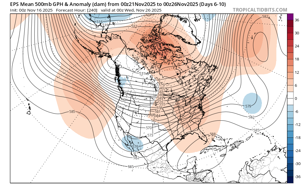
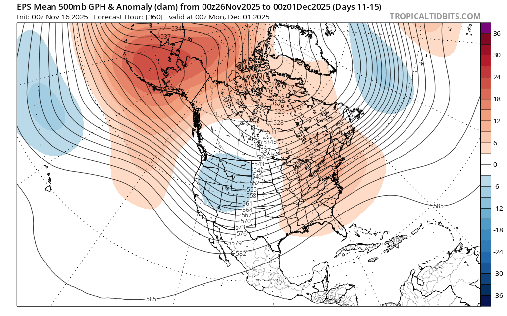
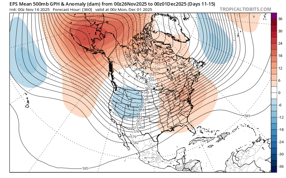
Still first week to me. This is last day of Nov huge neg EPO ready to unload and heading east..png.86f74c986bd33cf37c50292002e30b71.png)
.png.e1efec8b8cb5e1aa294affde8aa1ee0f.png)
-

November 2025 general discussions and probable topic derailings ...
CoastalWx replied to Typhoon Tip's topic in New England
We know why…. -
November 2025 general discussions and probable topic derailings ...
CoastalWx replied to Typhoon Tip's topic in New England
Gonna turn those departures around by end of week. Mowvember is back baby. -

November 2025 general discussions and probable topic derailings ...
dendrite replied to Typhoon Tip's topic in New England
Feels like fall -
At least November was cold and there were so many frosts. Different year
-
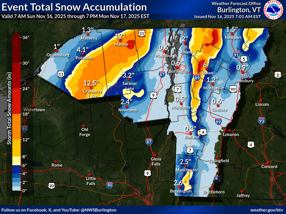
I guess folks weren’t kidding about the potential for some additional snow. We were under a Winter Weather Advisory for the front end of this system, but I woke up to find that we’re now under a Winter Storm Warning as the storm continues. Even in the valley here, the BTV NWS point forecast suggests the potential for 6-12”+. Current maps from the BTV NWS are below, and it looks like they reeled in those areas of darker red 24-30” shading in the updated version of the Event Total Snow Accumulation map, but there are still substantial areas of 18-24” shading.

-
November 2025 general discussions and probable topic derailings ...
CoastalWx replied to Typhoon Tip's topic in New England
How dare you? -
 I'm only 27 here for the monthly low, grass still mid summer green.
 -
November 2025 general discussions and probable topic derailings ...
CoastalWx replied to Typhoon Tip's topic in New England
He spoke only up to T day lol. im after the first week of December. Enjoy the cutters for now. -
November 2025 general discussions and probable topic derailings ...
dendrite replied to Typhoon Tip's topic in New England
Would be wild if I could get to December with a min of only 26°. -
Lol he is down huh.. It's always been a dream for deep winter weather starting right on Black Friday. I can't recall that happening here in terms of cold and snow.. Just not common in Southern CT.
-
Stein with words of deer wisdom https://x.com/growingwisdom/status/1990010067962183872?s=46&t=dhcbvkjmRcyBVQtDxJ3lRg
-
Looks like the wind is back for the next 6 months. Wind and clouds are our strong points. I feel like it's been years since I've seen an all day rain event. This weather is as exciting as watching paint dry.
-
Noyes nailed this whole thing happening on that video
-
November 2025 general discussions and probable topic derailings ...
dendrite replied to Typhoon Tip's topic in New England
Yes. Should be some upslope there today. -

November 2025 general discussions and probable topic derailings ...
alex replied to Typhoon Tip's topic in New England
Went up to 32.2 but started snowing. Cold air coming in aloft? -
November 2025 general discussions and probable topic derailings ...
dendrite replied to Typhoon Tip's topic in New England
Open the windows next Friday night?