All Activity
- Past hour
-

12/12: The little Friday clipper that could? Or won't.
bncho replied to dailylurker's topic in Mid Atlantic
The rich get richer. And the poor get poorer. And the happy get happier. And the sad get sadder. -
Yeah so for me to take any real value of this having meteorological significance I need to see statistical correlating variables, which is why I've done a lot of work around correlations and partial correlations involving ENSO states, rate of change involving the SOI, etc and found minimal forecast/predictability value for snowfall locally. I've been burned by threshold/relational things in the past (SAI being chief among them) and have since really been hesitant on overfitting data to find some grain of predictability to it.
-
Thank you. Seems logical. .
-
I mean...if we can get the ao/nao domain to start latching on to this idea....I know...way out in la la land.

-
Much better.
-
I think another thing is that we all have both recency bias and the feeling that things were better and grander in our younger years - whether it’s winters, pop music, sports teams, movies, etc. .
-
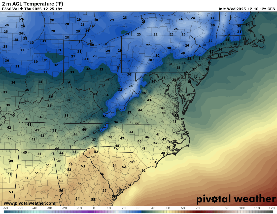
1pm
-
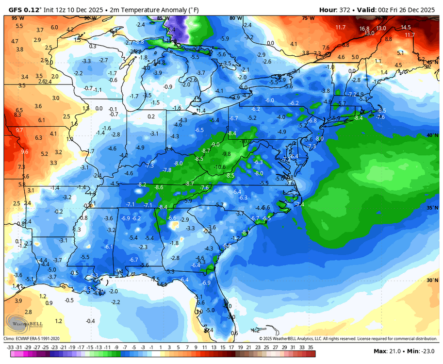
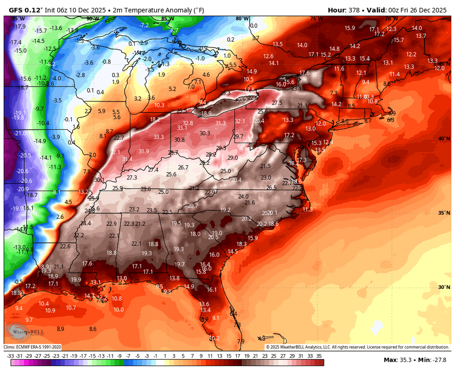
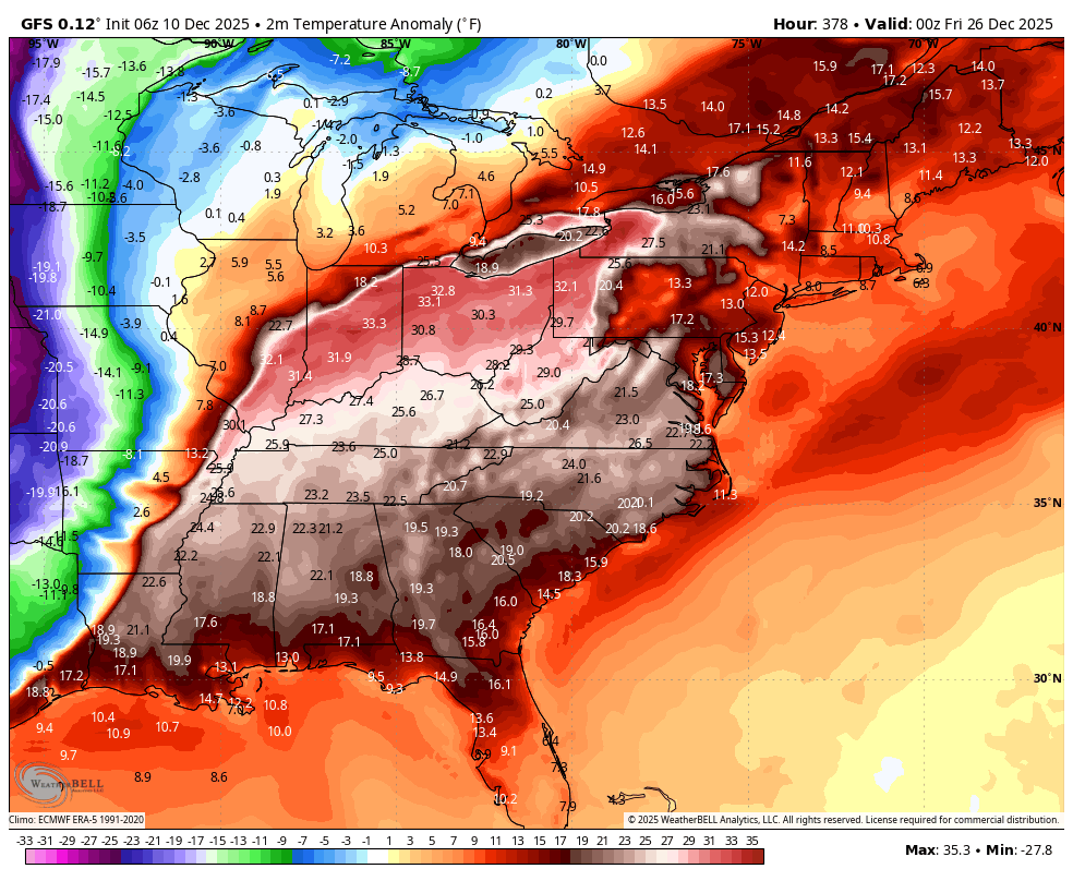
WB 12Z GFS Christmas temp. anomaly compared to 6Z.
-
What does this map show and mean? I paused my eating of crayons to try and learn something. TIA. .
-
I'm fine if this is a one or three day event. I don't want to see this ridge just set up and bake for weeks on end.
-
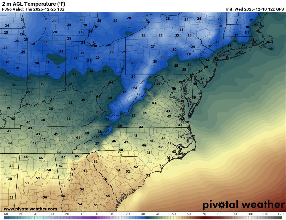
Around 40 for Christmas Day... so not too bad
-

December 2025 Short/Medium Range Forecast Thread
Carvers Gap replied to John1122's topic in Tennessee Valley
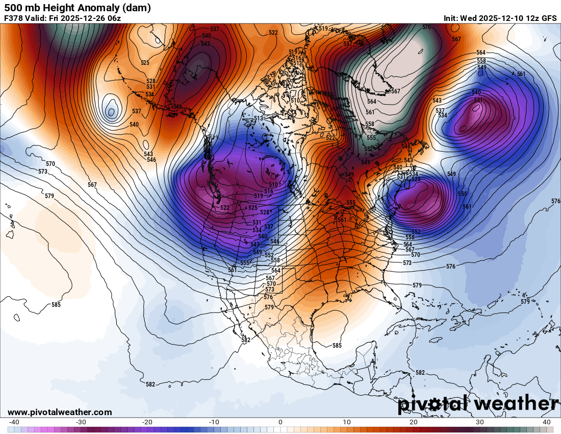
Understandable but still wild....some big swings in the d+10 range. The left is the new GFS run. IF Alaska has a block like that, that trough likely corrects eastward. In that trough is very cold air. At 0z, the pattern was less amplified and blocky. The left has an east based NAO and a full fledged Alaskan block. As a result, the 12z GFS finds a cold front on Christmas Eve. It isn't huge, but interesting to see it parked right in the middle of the warm-up. -
To 20's Christmas morning! lol That -nao is trying
-
More or less normal.
-
I’ll take a blend of euro and gfs for mby
-
Oh I sorry, I opened a can of worms with that question post I made earlier!
-
60s for Christmas Eve on the 12z GFS lol
-

Snowstorm potential 12/14/2025
SnowGoose69 replied to WeatherGeek2025's topic in New York City Metro
One thing I will say before the Euro comes out is it has been insanely good the last 3-4 weeks on these MW/Lakes storms. It obviously has been pretty mid on the E Coast. Thats been a tendency now for a few years. For awhile it sucked over amping everything in the 90-120 period. Since the most recent upgrade that bias is gone and its tended more to underamp in the 48-96 period or just do something/ANYTHING that is different from all other models. The good news so far is everything moved towards it the last 2 cycles and this system is a different setup than the one it botched last week so perhaps its onto the idea this time -
I can confirm! .
-

December 2025 regional war/obs/disco thread
Damage In Tolland replied to Torch Tiger's topic in New England
That look is exactly how the monster I storm happened in Montreal and NNE in 98. This time that would be over SNE/CNE -
First flakes starting here. Looks like around 0.5 to 0.6 of QPF, hoping for some denser 10:1 type stuff so we can build our base to withstand the next couple weeks.
-
6z Euro looked a bit north..hopefully we can get it back shortly.
-

Central PA Winter 25/26 Discussion and Obs
Itstrainingtime replied to MAG5035's topic in Upstate New York/Pennsylvania
Well...yuck: @MUweather I'm becoming convinced that this persistently cold pattern ends by the middle of next week. The MJO may just stay in the COD & have very little influence on the pattern over the next few weeks. The SPV will also rapidly strengthen after mid-month & remain strong in Jan. Additionally, ensemble models show a major retraction of the Pacific Jet between ~Dec 17-22. As a result, a massive Bering Sea ridge develops & stays in place for weeks. The Bering Sea ridge often precedes an eastern U.S. warmup & flareup of the Southeast Ridge by 6-10 days. -
Next winter may be telling, its TBD but if we have lets say a 0.6-1.2 El Nino and we continue to see the PDO sit more near -1 to like + 0.5 we really want to see some degree of slowing Pac flow/less -PNA etc...if we still see a heavily Nina type pattern even in that type of regime we may be in trouble or at least waiting 5-10 years til we see the Pac go back to a +PDO ERA
-
as per the norm, areas out in the hills reporting 6 inches, while we get half that here on east side.


.thumb.JPG.418e8a9a2902ae687ec35ff4bc0e038e.JPG)