All Activity
- Past hour
-
69/52. refreshing
-
Supposed to rebound later. We shall see
-
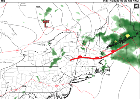
12z NAM looking more warm sectory in the grid: 54006967438 01098 152008 72181814 60000985338 01796 121809 74211814 That's a SSW wind at Logan, with 900 mb T to +18C ... 100mb is +21C at 18z, which is probably good for 26 C in the 2-meter. ALB and LGA are both +25C at that level, which is about 30 or 31 in the 2-meter. We may have some still lingering frontal droop E of the Berk's but that's definitely more Euro suggestive. Here's the NAM's synoptic representation at 18z
-
I didn’t know Kevin knew how to hack into your stuff. Well done CT Blizz!
-
ideal!
-
It has reached here now as I went from 82 to 75 pretty quickly
-
models usually underestimate the SW push of the back door fronts....
-
neighborhood was a ghost town lol...today people are doing things in the neighborhhood..
-
Companies have figured out how to prevent and kill crabgrass BUT they don't want to sell those products because there is more money to be made from "treating" crabgrass..
-
Everyone was out and about earlier this week. Pools, beach etc. Nobody is out now and many are cranky.
-
Good lawn mowing weather
-
those droughts are why the summers of 1953 and 1966 have never been matched for 100+ heat
-
The water in Wildwood NJ was quite nice last weekend. The surf was meh.
-
I've seen more people out and about today than I saw combined for Mon-Wed..
-
the really hot summers began with 1944, the 1944s and 1950s were a cut above everything that happened before and since. And a few of the 1960s, like 1966, has never been matched.
-
Down to 69
-
Too cold unless you're laying down asphalt or clear cutting forests.
-
If we had a drought and this was a month later, then maybe the 2010 and 2011 highs of 108° could have been challenged. Hard to say for sure. But it’s interesting that this strongest heatwave in over a decade followed the record westerly flow this past winter into spring. Even though we are seeing a quick return to easterly flow. Plus continuing the measurable rainfall on weekend pattern without it being a washout. I guess we are lucky that we haven’t experienced any severe droughts like we had from the 1960s to around 2001. Since droughts of that magnitude with the warmer background pattern would probably support 110°+ peak heat and our first consecutive 10 days reaching 100° and perhaps a 25 day official heatwave of reaching 90°. While this heatwave only produced some scattered outages, not sure how well our power grid would hold up with such extreme drought feedback driven heat.
-
Many models yesterday had a stripe of mid 80s for 2PM today in NYC and western LI because they showed temps never really dropping below the upper 70s. Needless to say they all busted pretty badly.
-
it's mostly minimum driven, the highs and lows have become compressed
-
August 26-28 had an extreme 3 day 100+ heatwave though
-
Same here. There was a nice little storm yesterday that missed me by a half mile. I could smell the rain and see the lightning, but all I got was a few raindrops. Definitely look forward to a widespread rainfall.
-
Even July 1936 which has the 106 record in Central Park finished below normal using today's fake averages. Our baseline is higher and we don't get those nice coolshots in between the heat episodes like we used to, or at least they are much more rare.
-
Grateful for the 1.08" of rain last night about 7:00. But the winds were bad and we got about 5 minutes of dime to nickel sized hail. What is amazing about the storm is that it came down from the north. We just don't get many storms that severe that make it over the mountains of South Carolina without breaking up. I guess it was a testament to how unstable the atmosphere was. There was large hail reported near the apple orchards in Henderson County. Has anyone heard if there was damage to the apple crop?
-
sat-mon looks like our next potential heat wave


