All Activity
- Past hour
-

2026-2027 Strong/Super El Nino
snowman19 replied to Stormchaserchuck1's topic in Weather Forecasting and Discussion
-

2026-2027 Strong/Super El Nino
SnowGoose69 replied to Stormchaserchuck1's topic in Weather Forecasting and Discussion
There is no question there is some type of correlation too, at least for places like AL/GA/MS/SC for the frequency to be higher during the cold AMO periods. That does not seem to be as much a factor for TN/NC/AR/OK/TX. But there is a higher peak, even in El Nino winters for those other 4 states in the 70s/80s and even during the more neutral or weaker warmer AMO period of the 40s/50s. I don't know if that is purely that colder outbreaks are more common then or perhaps/phasing amplified systems that cut north of them are less likely. -

2026-2027 Strong/Super El Nino
forkyfork replied to Stormchaserchuck1's topic in Weather Forecasting and Discussion
i've skimmed through the first 10ish pages of this thread and a lot of you should be embarrassed -
it matters when deniers are using 100ths of a decimal to make dullard points
-
Should I uninstall? I figure if I was supposed to install in March or something, that woud make sense
-

2026-2027 Strong/Super El Nino
GaWx replied to Stormchaserchuck1's topic in Weather Forecasting and Discussion
Agreed. I didn’t say 26-7 wasn’t looking E based. I’m saying it doesn’t look as E based as 1982-3 and not anywhere close to (not even in the ballpark) as E based as 1997-8. You posted earlier today this: “Not only does it show the strongest El Niño in history, it shows it being severely east-based/East Pacific like 1997 was.” This (“severely east-based/EP like 1997”) is not true when you compare the regions, which is how E based/C based/Modoki are defined. -
2026-2027 Strong/Super El Nino
snowman19 replied to Stormchaserchuck1's topic in Weather Forecasting and Discussion
It’s still going to be east-based Edit: @GaWx By “severely” I mean warmest anomalies centered in region 1+2 -
2026-2027 Strong/Super El Nino
GaWx replied to Stormchaserchuck1's topic in Weather Forecasting and Discussion
But it’s less E based than 82-3 and much less E based than 97-8 as I just showed. Since you’ve been emphasizing how much E based 26-7 is looking, what do you think about this? -

Central PA Summer 2026 Discussion/Obs Thread
canderson replied to Voyager's topic in Upstate New York/Pennsylvania
Timing might be an issue getting anything severe here. We’ll see! -
1997-98 comps and crayon drawers get nuked.
-
Why, what's up?
-
Back broken?
-
Have to wait until after dark? This is DOA.
-
The leaves have that leathery look.
-
2026-2027 Strong/Super El Nino
snowman19 replied to Stormchaserchuck1's topic in Weather Forecasting and Discussion
-
2026-2027 Strong/Super El Nino
GaWx replied to Stormchaserchuck1's topic in Weather Forecasting and Discussion
Regarding 1+2 less 3.4 per the table link below, 1982-3 fall/winter monthly peak was +1.1. This is based on Nov, which had 1+2 at +3.0 vs 3.4’s +1.9. 1997-8 peak differential was way up at +2.1 (also in Nov)! This is based on 1+2’s +4.5 vs 3.4’s +2.4. But the Euro per Ben’s quoted charts above has a mere only ~+0.7 for 2026-7’s peak monthly 1+2 less 3.4, which is in Sept with 1+2 then ~+3.8 vs 3.4’s ~+3.1! So, the Euro is actually forecasting 26-7 to have a somewhat weaker 1+2 less 3.4 than 82-3 and MUCH weaker than 97-8. So per this measure, it’s forecasting a less E based 26-7 than 82-2 and MUCH less E based than 97-8. Monthly ERSST: https://www.cpc.ncep.noaa.gov/data/indices/ersst5.nino.mth.91-20.ascii -
Yeah, I saw that. HS state track going on yesterday, and today. Finals are today. My gson has qualified in the 110m & 300m hurdles. THHS is in Section 7A. At state they compete within Class A. 3 classes in the state. A, AA, AAA with their respective Sections. Hopefully nothing will pop this aftrn down there at St. Michael.
-

2026-2027 Strong/Super El Nino
csnavywx replied to Stormchaserchuck1's topic in Weather Forecasting and Discussion
What happens when you get 1997 and 1972-like wind stress patterns with 2026 OHC/SSTs? We're about to find out. -
I was fortunate to get 0.94" overnight and this morning because, overall, this disturbance did not drop the widespread 1-3" some models were advertising a day or two ago. Areas from Iowa City east and south got almost nothing. There was also zero lightning/thunder with this rain. It had also looked like Friday night would be a good storm/rain event across the area, but now that appears to be gone south, so there are some spots in ec/se Iowa that will get nothing from both nights.
-
2026-2027 Strong/Super El Nino
csnavywx replied to Stormchaserchuck1's topic in Weather Forecasting and Discussion
Let this be a lesson that the state and path dependency are more important than generally given credit for. Arguments about the spring barrier tended to discount this by default and also discount that these models have to parameterize certain calculations that end up biasing them *cold* on big honking tail events like this. -
Yup a little worried about that. But targeting probably E NY/NW MA/S VT area tomorrow.
-
Good call, but a little quick in progression.
-
2026-2027 Strong/Super El Nino
csnavywx replied to Stormchaserchuck1's topic in Weather Forecasting and Discussion
Sitting near/at record highs now. - Today
-
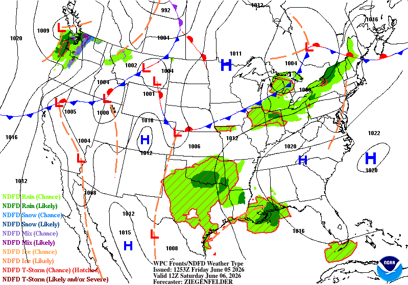
June 5 1930: Heavy rain falls at Waseca. 4.3 inches of rain would fall over 24 hours. 1915: This date marks the first of a long stretch of days of measurable rain at Winton near Ely. Measurable rain would fall on each day until 19th. The total amount of rain for the fifteen days was over six inches. For Friday, June 5, 2026 1859 - Frost was reported from Iowa to New England. The temperature dipped to 25 degrees in New York State, and up to two inches of snow blanketed Ohio. The cold and snow damaged the wheat crop. (David Ludlum) 1908 - Helena MT was deluged with 3.67 inches of rain to establish their all-time 24 hour rainfall record. (4th-5th) (The Weather Channel) 1916 - A tornado struck the town of Warren AR killing 83 persons. There were 125 deaths that day in a tornado outbreak across Missouri and Arkansas. (David Ludlum) 1917 - Residents near Topeka KS reported disk-shaped hailstones six to ten inches in diameter, and two to three inches thick. The hailstorm was accompanied by a tornado. (The Weather Channel) (Note: Very rare, wow!) 1987 - International Falls, MN, dipped to a record low reading of 34 degrees during the morning. Williston, ND, and Glasgow, MT, reported record warm afternoon highs of 94 degrees. Major flooding was reported along the Guadelupe River in South Texas, with the water level at Cuero reaching 18 feet above flood stage. (The National Weather Summary) (Storm Data) 1988 - Twenty cities in the south central and eastern U.S. reported record low temperatures for the date, including Asheville NC with a reading of 40 degrees. Fifteen cities in the north central U.S. reported record high temperatures for the date. The high of 108 degrees at Glasgow MT was a record for June. (The National Weather Summary) 1989 - Thunderstorms produced severe weather from the Lower Mississippi Valley to the Southern Atlantic Coast during the day and into the night. Four tornadoes were reported, and there were 87 reports of large hail and damaging winds. (Storm Data) (The National Weather Summary)
-
Only thing annoying is a batch of mid level clouds trying to spoil the sun midday. Maybe even a few sprinkles. May affect aftn development.


