All Activity
- Past hour
-

2026-2027 Strong/Super El Nino
GaWx replied to Stormchaserchuck1's topic in Weather Forecasting and Discussion
Today’s CFS has a record high RONI starting in JAS and going through NDJ before dropping at a record quick pace to only 3rd highest in DJF. I’m talking about records for each respective 3 month period, not overall. On monthly basis, it has records Jul-Dec! But then Jan falls so fast that it is then 0.5 cooler than ‘83 and is only 5th warmest behind ‘83, ‘92, ‘98, and ,’16. Feb also is 5th warmest with it a whopping 0.63 cooler than ‘92! -
(002).thumb.png.6e3d9d46bca5fe41aab7a74871dd8af8.png)
Central PA Spring 2026 Discussion/Obs Thread
ChescoWx replied to Voyager's topic in Upstate New York/Pennsylvania
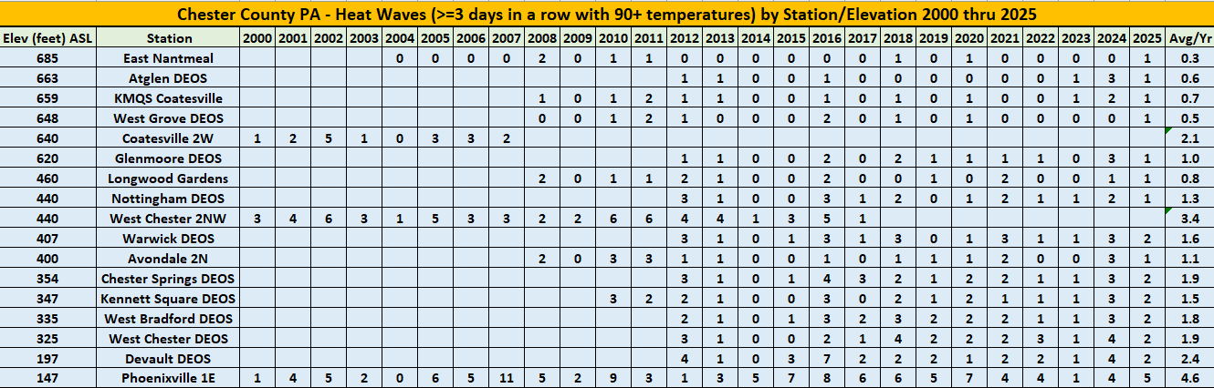
As we get into the summer months lower elevation (<450 ft asl) areas of Chester County PA will see at least one heat wave (defined as 3 or more consecutive days with highs at 90 degrees or above) while the relatively higher ridge locations (>600 ft asl) only average a heat wave every couple of years or so. Below sorted by highest to lowest elevation is a ranking of all reporting stations since 2000 with their recorded heat waves. Our lowest elevation spot at Phoenixville averages a whopping two to four times the number of heat waves as almost all other locations across the county.
-
E PA/NJ/DE Summer 2026 Obs/Discussion
ChescoWx replied to PhiEaglesfan712's topic in Philadelphia Region
As we get into the summer months lower elevation (<450 ft asl) areas of Chester County PA will see at least one heat wave (defined as 3 or more consecutive days with highs at 90 degrees or above) while the relatively higher ridge locations (>600 ft asl) only average a heat wave every couple of years or so. Below sorted by highest to lowest elevation is a ranking of all reporting stations since 2000 with their recorded heat waves. Our lowest elevation spot at Phoenixville averages a whopping two to four times the number of heat waves as almost all other locations across the county.
-
As we get into the summer months lower elevation (<450 ft asl) areas of Chester County PA will see at least one heat wave (defined as 3 or more consecutive days with highs at 90 degrees or above) while the relatively higher ridge locations (>600 ft asl) only average a heat wave every couple of years or so. Below sorted by highest to lowest elevation is a ranking of all reporting stations since 2000 with their recorded heat waves. Our lowest elevation spot at Phoenixville averages a whopping two to four times the number of heat waves as almost all other locations across the county.
-
Not too bad. 63 breezy partly sunny
-

Anomalous Late Spring storm May 30 2026
Damage In Tolland replied to HoarfrostHubb's topic in New England
Yes It is the tip of hell -
That’s impressive. Tip of the cap.
-
He didn’t lose…it’s even worse than everyone thought. In the 30’s on 5/30 during the heat of the day. Shorts Weather said nobody ever.
-
Shorts are fine today - if you are staying inside and the heat is on.
-
Anomalous Late Spring storm May 30 2026
Damage In Tolland replied to HoarfrostHubb's topic in New England
Honestly one of it not the worst weather days in my 53 years relative to time of year -
Reinstall backwards for heat?
-

Anomalous Late Spring storm May 30 2026
Chrisrotary12 replied to HoarfrostHubb's topic in New England
There was wind elsewhere? I mean we maybe gusted to 20? -
Anomalous Late Spring storm May 30 2026
Damage In Tolland replied to HoarfrostHubb's topic in New England
You lost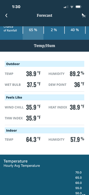
-
Can see MWN and Lafayette ridgeline glowing from over here. Love how fast it cleared up.
-
Went from 80% to 50% to 20% today. Looks like all the storms are south of us.
-

Anomalous Late Spring storm May 30 2026
CT Valley Snowman replied to HoarfrostHubb's topic in New England
Brutal day. 44, rain and wind. Congrats to those seeing snow or big-time winds because without it there's is no redeeming quality to today's weather. It's just awful. -
Poor guy busted bad last weekend too…..he struggling.
-
Like taking candy from a weenie.
-
Man we told Kev 40s. He laughed. We won.
-
Wow snow capped Ossipees. Never seen that this late.
-
Looks like they received 5.9 inches at top of Washington, but there could have been a touch more at some of the other high peaks but probably not based on the thermal profiles. Some modeling was a touch too cold, just my two cents. As everyone knows 1-2 degrees can make a huge difference.
-
Feels like October here-windy and temps have fallen down to 52 but dry
-
Should’ve came up last night. Just don’t bring your wife to Tilton House of Pizza.

-

2026-2027 Strong/Super El Nino
LakePaste25 replied to Stormchaserchuck1's topic in Weather Forecasting and Discussion
Super Ninos aren’t always record warm for the NE unless you get that competing Nina forcing from the W pac warm pool. The typical way to get record warm temps here is via the SE ridge which ushers in subtropical air from the Gulf. Ninos don’t have this and instead typically usher in a pacific jet extension which floods the lower 48 with mild pacific air, and you have a raging southern stream bringing cool and stormy weather in the south. This pattern is usually record warm for the northern plains and Canada, but not the NE. -

E PA/NJ/DE Spring 2026 Obs/Discussion
JTA66 replied to PhiEaglesfan712's topic in Philadelphia Region
Despite last week’s rain, I still managed to kick up a lot of dust mowing today. 61F/DP 45F