All Activity
- Past hour
-
February is the snowiest month in DC on average is it not? It’s not even January what is this lol
-

Possible Light Snowfall (1" - 4") on Tuesday Dec 23
eduggs replied to Northof78's topic in New York City Metro
The WPC maps have <10% probability for 2" of snow in the far northern reaches of the OKX forecast area, including elevations above 1000ft. That should have nothing to do with "white rain." Those areas might not get 2" of snow. But I would like to know what the basis is for assigning a probability of less than 1 in 10 chance. -
Possible Light Snowfall (1" - 4") on Tuesday Dec 23
eduggs replied to Northof78's topic in New York City Metro
Other than the usual weird jump by the NAM, so far 0z looks similar to previous cycles. Changes look like noise to me... Still looks like a coating to 3" or so from the south coasts to far northern suburbs with a ragged and unpredictable gradient... The variable and inconsistent geographic distribution of snowfall between models suggests a low probability forecast. Model changes are being driven by very minor differences in vorticity and micro-short-waves. The WRF-NSSL is the weenie model of 0z with 3-5" right through the NYC metro. Unlikely but probably not impossible. -

Occasional Thoughts on Climate Change
WolfStock1 replied to donsutherland1's topic in Climate Change
Some people aren't very good students of history, it appears. How many times do predictions of things like "food insecurity" have to be wrong in order for people to learn? Sorry but alarmism like this deservers to be mocked. It certainly doesn't help the cause any. -

2025-2026 ENSO
40/70 Benchmark replied to 40/70 Benchmark's topic in Weather Forecasting and Discussion
Agree on the Jan 15-Feb 1 timeframe. -

December 2025 regional war/obs/disco thread
WxWatcher007 replied to Torch Tiger's topic in New England
Best of both worlds. -

Possible Light Snowfall (1" - 4") on Tuesday Dec 23
Krs4Lfe replied to Northof78's topic in New York City Metro
They are probably favoring in the white rain due to warmer temperatures at the onset, which will lead to minimal accumulation in the urban zones of the tri state area. Either way, that should make for a solid 1-3” further inland -
Private forecast company out of the Midwest. Indiana I believe. Yes, legit. They were spot on last year with their calls of cold despite models when they were trying to break down the cold. But past performance is....
-
I would say he's fairly knowledgable, but he leans colder often. Definitely not weenie status though.
-
He also mentioned a lot about convections, but I don't know anything about that, so hopefully somebody more knowledgable can explain
-

December 2025 regional war/obs/disco thread
moneypitmike replied to Torch Tiger's topic in New England
Lol. Ww still hsve Pit2 in Maine. As ling as we still have that, I'm fine. -
Who is Bamwx. Is he legit?
-
New video this evening from BAMWx (see link below) (I haven’t watched it yet)(don’t know why it shows twice but couldn’t fix it) Summary from @bncho Here were my main takeaways from this video: 1. Dec 29-31 will trend colder, like it has been for the past few days. 2. He thinks there'll be a big storm favoring NE for the first week of January; his top analogs like 1996 and 2000 3. Somewhere between the end of Dec and the start of Jan, he thinks that WWBs will happen, causing: - the death of La Nina - -EPO by early Jan, but no +PNA - MJO to move very quickly and finally get unstuck thru phases 2, 3, 4, etc., finally getting back into 7 by around Jan 15 (just in time for prime climo) 4. He likes the fact that the PV is on our side of the hemisphere, and he thinks it'll stay there 5. The models are not seeing the cold in the long-range TL;DR: BAM WX believes that there will be a prolonged period of cold and stormy weather from Jan 15 to Feb 1. The first two weeks of January will likely offer shots of cold, but with relaxations in between.
-
White Christmas Miracle? December 23-24th
40/70 Benchmark replied to Baroclinic Zone's topic in New England
925 looks cold enough for a lot of the region, so if there's decent growth and some consistency with halfway decent rates, it should be okay. -
White Christmas Miracle? December 23-24th
moneypitmike replied to Baroclinic Zone's topic in New England
We begin battling the increasing sun angle tomorrow. -

White Christmas Miracle? December 23-24th
bristolri_wx replied to Baroclinic Zone's topic in New England
Biggest issue in coastal plain may be surface temps. It may be snowing but might be tough to accumulate, especially during the daytime hours. NAM 3K soundings show 33/35 right at the surface though its colder throughout the rest of the column. If we can get it a pinch colder then maybe we can sneak in an extra inch or so. -

Winter 2025-26 Medium/Long Range Discussion
sbnwx85 replied to michsnowfreak's topic in Lakes/Ohio Valley
I like watching BAM’s videos for how unhinged he’s becoming. -

December 2025 regional war/obs/disco thread
H2Otown_WX replied to Torch Tiger's topic in New England
You are now in snow hell, unless '04-'05 or '14-'15 walks through that door. Convince the wife to move back? -

2025-2026 ENSO
donsutherland1 replied to 40/70 Benchmark's topic in Weather Forecasting and Discussion
Those are large differences. I'm not sure whether the algorithm is faulty or their methodology is off. -

Central PA Winter 25/26 Discussion and Obs
Ruin replied to MAG5035's topic in Upstate New York/Pennsylvania
how much do we tech need for it to be called a white christmas? -
White Christmas Miracle? December 23-24th
moneypitmike replied to Baroclinic Zone's topic in New England
I'll take my Pit2 p/c. Tuesday Snow likely, mainly after 4pm. Mostly cloudy, with a high near 34. Calm wind becoming southeast around 5 mph in the afternoon. Chance of precipitation is 60%. New snow accumulation of 1 to 2 inches possible. Tuesday Night Snow. Low around 21. East wind around 5 mph becoming north after midnight. Chance of precipitation is 80%. New snow accumulation of 3 to 5 inches possible. -
.thumb.png.23ea14c370d0e742167dfceb25594fa8.png)
-

December 2025 regional war/obs/disco thread
Torch Tiger replied to Torch Tiger's topic in New England
thank goodness this dark day and night bs is nearly over with. up up up! Cars will be warming in a few short weeks, and up to perhaps 80F-90? by early February -
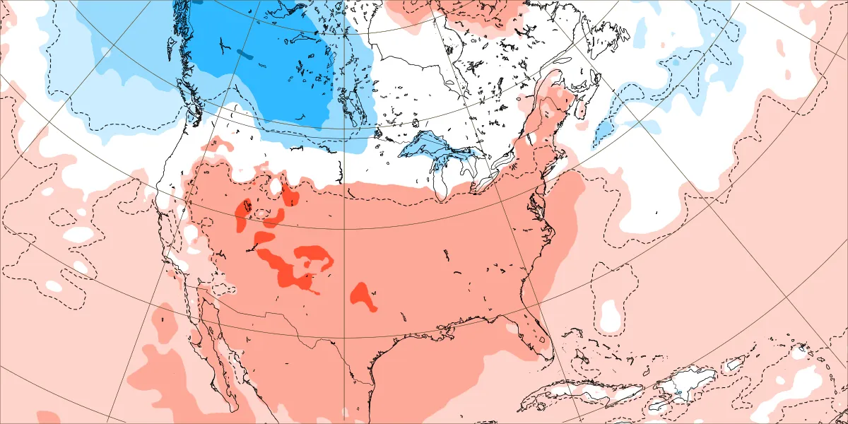
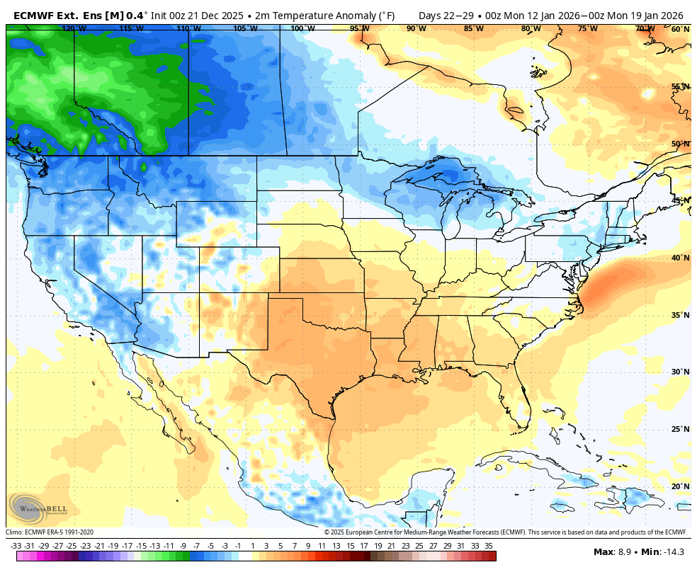
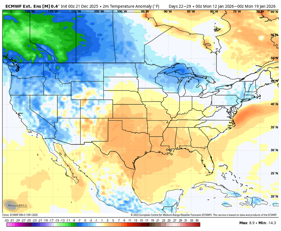
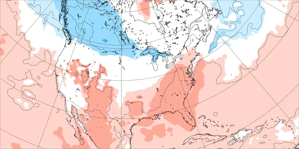
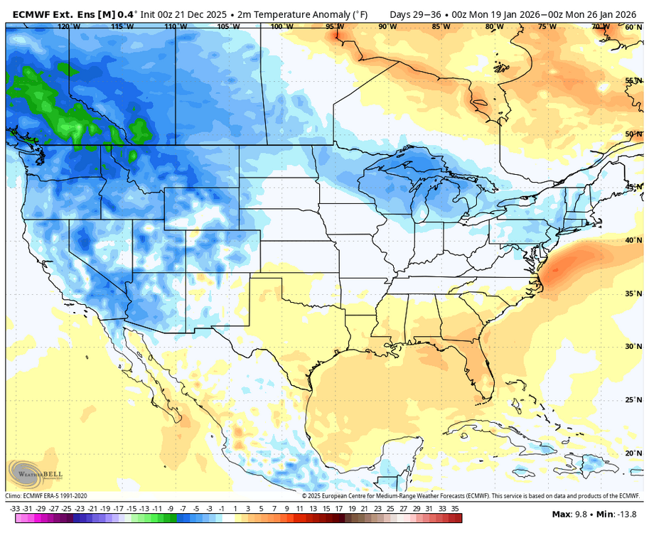
I continue to have a concern about certain WxBell maps being off. I’ve discussed the CFS being wacky and mainly too cold a number of times with@donsutherland1. But I also can’t figure out why their Euro Weekly (EW) maps are always colder than the ECMWF’s own EW maps! To me it just tells me that the WB EW maps are significantly too cold, period, which remains a concern. Why are they too cold? It’s definitely not due to climo base differences because if anything the in-house uses warmer climo (last 20 years), not colder, vs WB’s 1991-2020. Warmer climo means colder in-house anomaly maps, the opposite of reality! So, that makes the discrepancy even worse! Here’s examples from today’s EWs: 1. For Jan 12-18th: ECMWF: AN ~80%, BN ~2% of US WxBell: why do they have… - AN in only ~1/3 of US vs 80% on in-house? - BN ~25% of US vs only 2% on in-house? ————- 2. For Jan 19th-25th: ECMWF: AN ~50%, BN ~ 3% of US WxBell: why do they have… - AN in only ~15% of US vs 50% on in-house? - BN ~50% of US vs only 3% on in-house?

-
Yes I deleted it. Drunk.


.png.49e1d18f6a858220e747fdaeb9ac3287.png)