All Activity
- Past hour
-

September 2025 OBS-Discussion centered NYC subforum
donsutherland1 replied to wdrag's topic in New York City Metro
The guidance still has the showers/light rain. Whether they're correct remains to be seen. -
The last frame of 6Z Euro has this stop its ENE movement and then suddenly drift back due W fwiw as Humberto accelerates away and the upper high builds enough to its N to change the steering. Although this is the only major op doing this, 40% of the 6Z EPS do not escape and most of those stall not too far offshore and then attain a W component of motion.
-

Potential Tropical Cyclone Nine
Kevin Reilly replied to WxWatcher007's topic in Tropical Headquarters
Yea this looks like a depression now or by 11 am as you said. Humberto is pretty far away east from this system. It’s obvious that Humberto turns out to sea gotta wait to see how high pressure builds into the Northeast and Mid Atlantic to put the block in place to initiate movement towards South Carolina, then the stall of Imelda, followed by the bounce off the high to the north and deflection out to sea. Pretty simply put all about exact timing of players build and strength. -
I say bring it. We definitely need some good rain here in Eastern PA.
-

E PA/NJ/DE Autumn 2025 Obs/Discussion
PhiEaglesfan712 replied to PhiEaglesfan712's topic in Philadelphia Region
Today is the 40th anniversary of Hurricane Gloria: This was as bad as Sandy, maybe even worse. -
Another bust and OTS she goes.
-

Potential Tropical Cyclone Nine
WxWatcher007 replied to WxWatcher007's topic in Tropical Headquarters
It looks like there may be enough of a wind shift to designate this at 11am. -
Potential Tropical Cyclone Nine
Kevin Reilly replied to WxWatcher007's topic in Tropical Headquarters
Looks like a center is going to form just north of Cuba on the north Cuban Coast / south of the Bahamas and lift north bound. -
Well this mornings GFS has snow for those visiting on Columbus Day weekend. At least if the foliage is gone they’ll have something to look at!
-
Days are getting shorter, nights are getting colder, who knows what weathers in order... One thing is guaranteed, however, its Spooky Season! Sent from my SM-S166V using Tapatalk
-

2025-2026 Fall/Winter Mountain Thread
Maggie Valley Steve replied to Buckethead's topic in Southeastern States
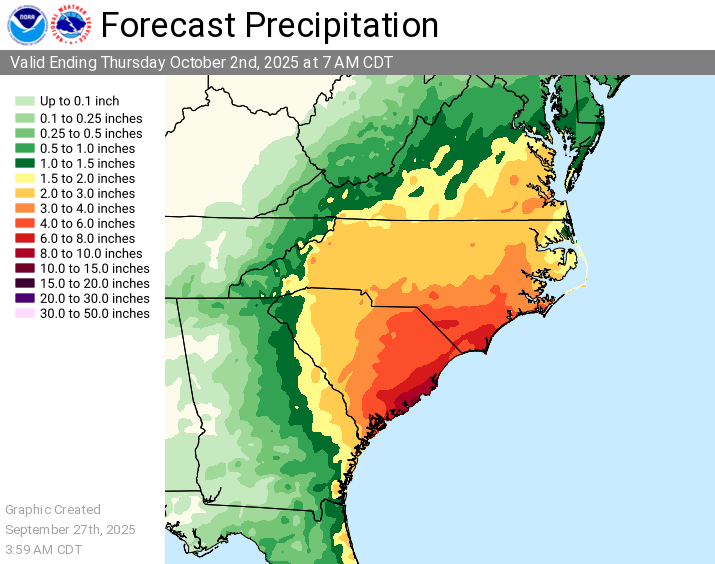
Morning Update from the WPC regarding excessive rainfall and amounts.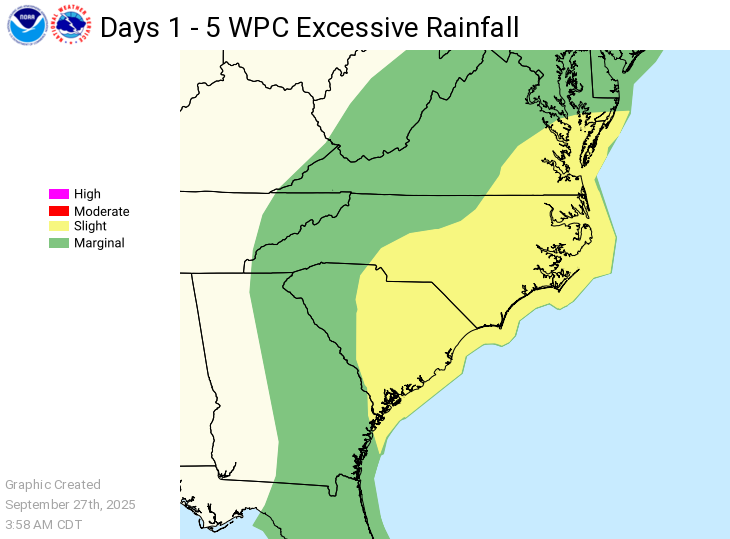
-
Potential Tropical Cyclone Nine
WxWatcher007 replied to WxWatcher007's topic in Tropical Headquarters
SHIPS has some decent odds of RI occurring relative to climo. Maybe something to watch as the organizational trend continues today. -

September 2025 OBS-Discussion centered NYC subforum
Sundog replied to wdrag's topic in New York City Metro
Maybe some light rain overnight? Who knows, you can't trust models 12 hours out anymore. -
Potential Tropical Cyclone Nine
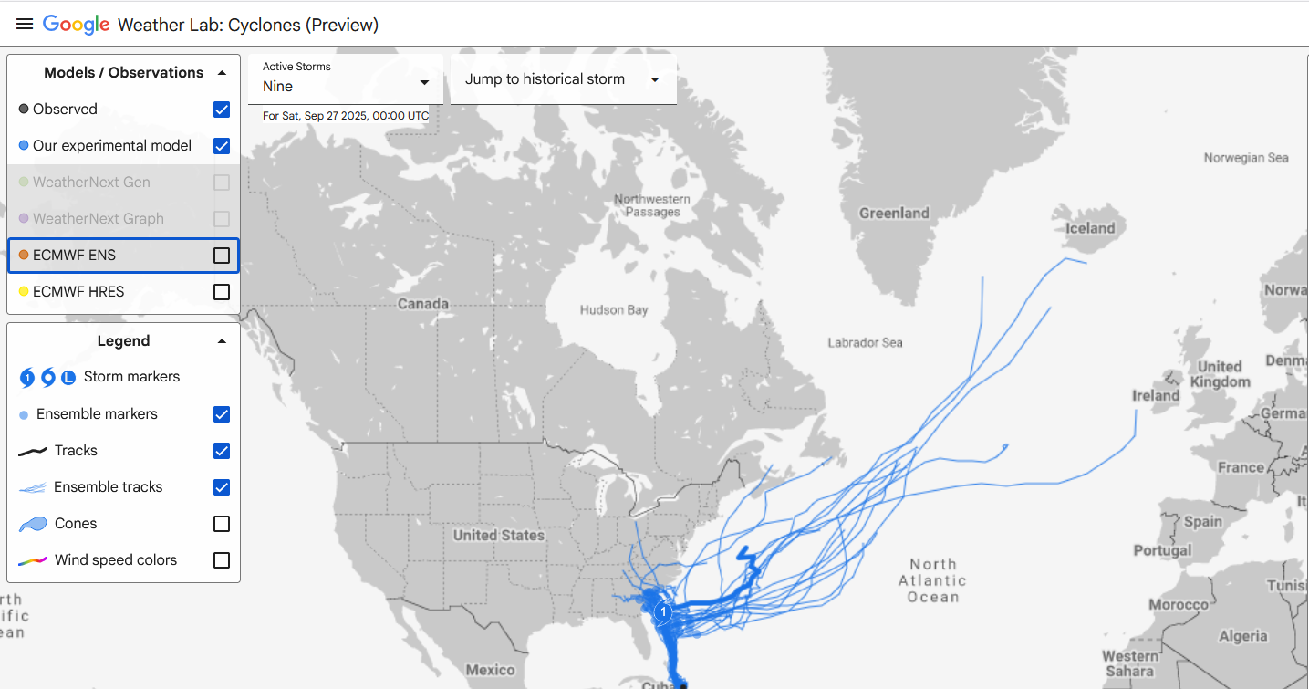
donsutherland1 replied to WxWatcher007's topic in Tropical Headquarters
With the NHC now referring to Google DeepMind in some of its discussions, below is the latest Google DeepMind output for PTC9 at closest approach on the ensemble mean track: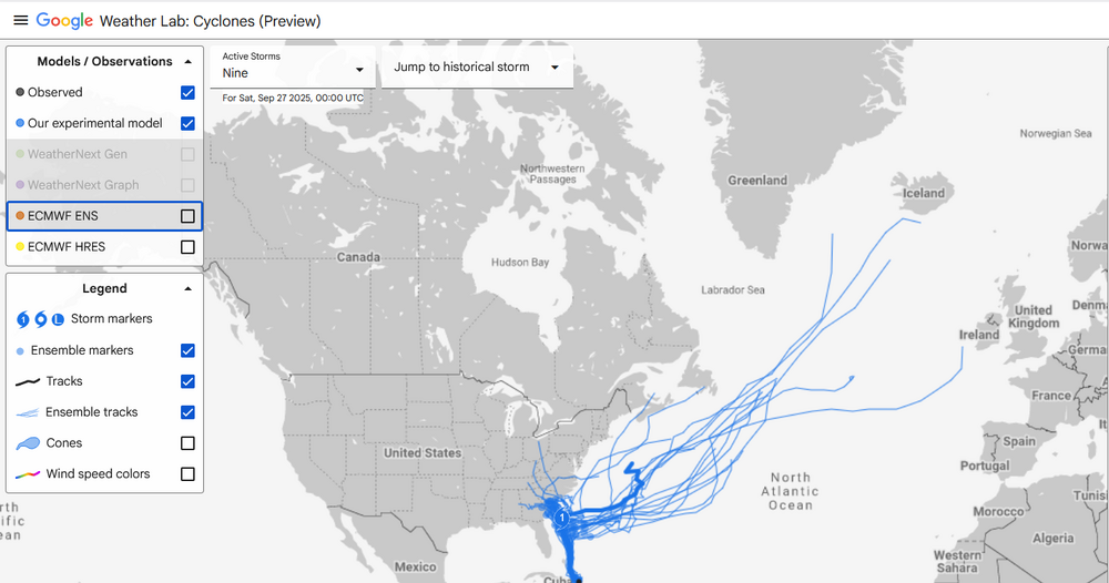
- Today
-
September 2025 OBS-Discussion centered NYC subforum
donsutherland1 replied to wdrag's topic in New York City Metro
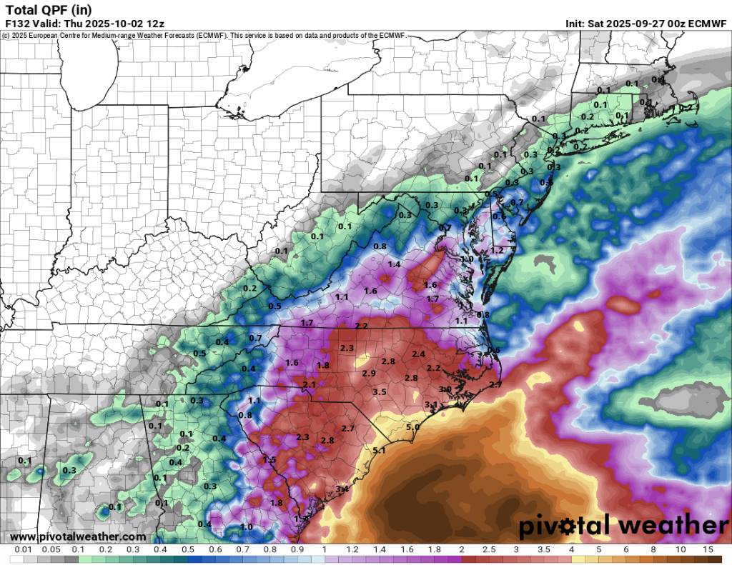
My thoughts on what will become Imelda, while recognizing that there is still some uncertainty: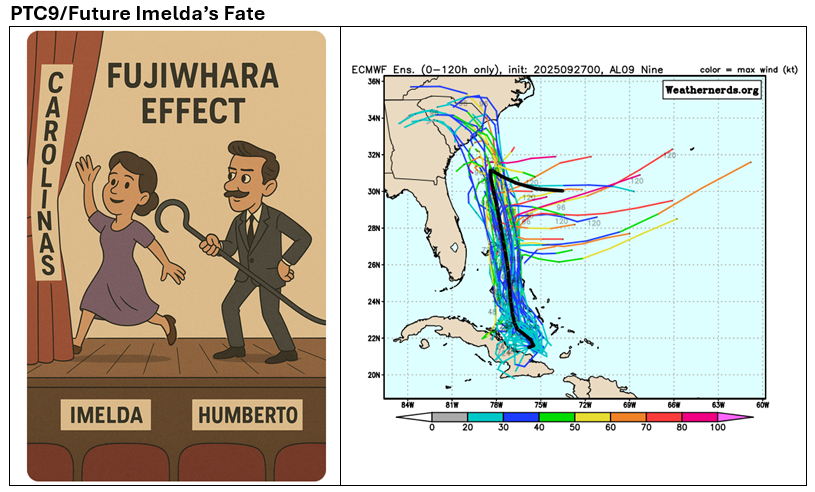
-
Cmc and euro ai want to bring it to the Mid Atlantic/ north east before all is said and done...... that's after wandering off the south east. Will have to keep an eye on that to see off that becomes a thing or not.
-

September 2025 OBS-Discussion centered NYC subforum
WestBabylonWeather replied to wdrag's topic in New York City Metro
On sale for 1099 this week. Microcenter can’t even touch it Intel Core i5-14400F NVIDIA GeForce RTX 5070 12GB 16GB DDR5 RGB 5200MHz (16x1) 1TB NVMe SSD Windows 11 Home -
What a turn on the models from the past 24 hours. Seems like the interaction with Humberto will pull Imelda out to see and keep it from making landfall as it seems currently with the models. This is the 06z gfs and the 00z euro. Looks like the coast is getting racked but I still think we see some adjustments made. With the pull from Humberto and a strong backdoor cold front blowing through we might just make it out with some beneficial rainfall in parts that need it and no flooding in the area. Sent from my SM-G998U using Tapatalk
.thumb.jpg.01b1673f03ff42019623e057fb21d8d2.jpg)

-

September 2025 OBS-Discussion centered NYC subforum
forkyfork replied to wdrag's topic in New York City Metro
it's so hard to get a normal down that lasts more than a month -
The stall looks legit. All the models show it.
-
6z Euro gets trapped AI was almost fun and the 6z GFS gets trapped just a bit to far out for now.. we track!
-
Potential Tropical Cyclone Nine
WxWatcher007 replied to WxWatcher007's topic in Tropical Headquarters
As I hope we all learned yesterday, we’re nowhere near having all the answers on the medium and longer range track. From the very beginning we knew Humberto and the steering pattern made this a highly complex forecast and some of us kind of settled into believing a false consensus on the models(EPS/GEFS)—myself included. I don’t think we know what’s going to happen yet. We just have to keep monitoring and communicating the track uncertainty. There’s also fairly substantial intensity uncertainty. Recon is in the PTC and is finding westerly winds now so it’s on an organizing trend even if the low is still broad. We will eventually have a defined enough center for a TC designation. Importantly, this is on the edge of the deep convection firing north of Cuba. In this kind of situation we have to watch for center reformations if deep convection continues, which here could significantly impact track. One thing is clear: the PTC is organizing at a steadier pace given the recon findings and satellite appearance. -
Potential Tropical Cyclone Nine
donsutherland1 replied to WxWatcher007's topic in Tropical Headquarters
Courtesy of the Fujiwhara Effect, my thinking is that the stronger Humberto will pull what will become Imelda away from the coastline before U.S. landfall can occur and before ridging can rebuild overhead to break down the steering currents and later redirect Imelda toward U.S. landfall. The Bahamas and possibly Bermuda will need to closely monitor the developing tropical cyclone. There remains a degree of uncertainty.
-
September 2025 OBS-Discussion centered NYC subforum
Sundog replied to wdrag's topic in New York City Metro
We did have that major flooding event in East Queens and Western Nassau during the summer too. But obviously that's localized. But extremely rare either way. -
It’s already happening


.jpg.2aaeecf78cdcadd6c5cf22f2c82afd76.jpg)