
All Activity
- Past hour
-
 https://northtrustpharmacy.com/# canadian pharmacies online
 -
Briefly hit 95 today, dew point was a bit lower today. Right now it is about 10 degrees cooler than yesterday with a feels like about 20 degrees lower as dew points dropped to upper 70's.
-
Getting pretty dusty down here in Huntingtown. Hopefully tomorrow produces.
-
Latest Natty Blend into Sunday-
-
Honestly I know you have suffered down with rainfall, but it does seem the rainfall pattern is more active, and maybe the Nino is showing some effect despite it only being mid August. Of course just speculation on my part.
-
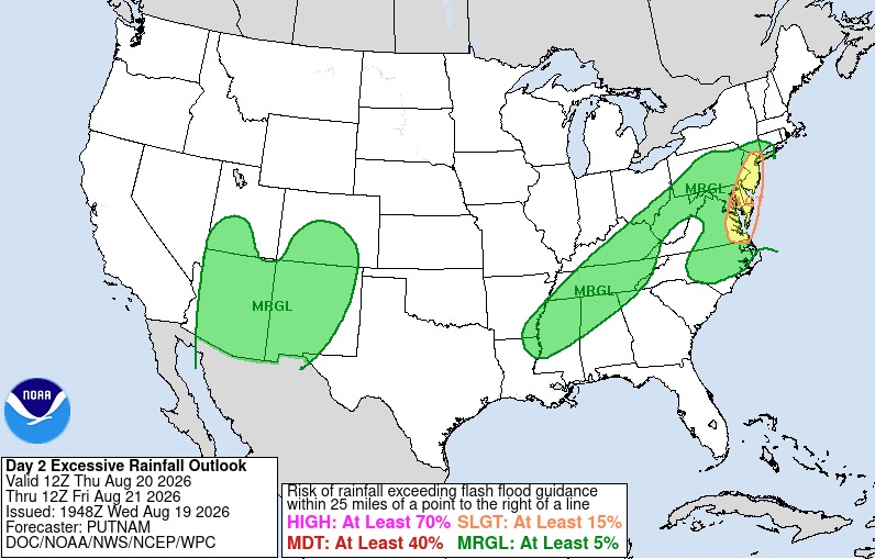
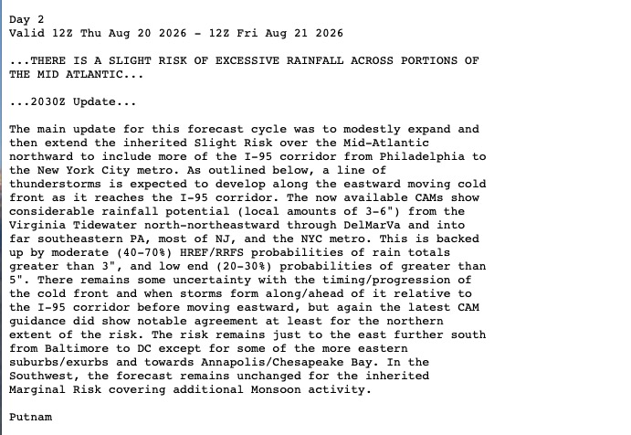
These constant heavy rain threats are becoming rather annoying I have to say. Too much now. Hoping for an under performer.
-
Yes it definitely will
-
A second round of potentially heavy rain looks possible as suggested on some of the guidance for Friday night and Saturday as the front possibly slows/stalls with disturbances riding along it. Probably favors places S and E along the coast.
-
 H2Otown_WX changed their profile photo
 -
As expected, now in the mode of stepping it down. Now a half to one inch possible for that period. Some places might see quite a bit more, and others next to nothing. Not sure why they don't stick to the standard 'tenth of an inch except higher amounts possible in thunderstorms' wording for these situations.
-

Augdewst 2026: Summer's Last Stand
vortex95 replied to Prismshine Productions's topic in New England
What about the RRFS (both versions?). -

Augdewst 2026: Summer's Last Stand
CoastalWx replied to Prismshine Productions's topic in New England
Sell and toss that hrrr output here - Today
-
My Twins swept by the phuglies then turn around and sweep the Braves...make it make sense
-
So if the cold arctic summer pattern is in place like the last two winters, and PDO is now rising, those are promising signs for this winter then.
-
.thumb.png.3513c28619bf91f0fa8e4004956c33df.png)
2026-2027 Record-breaking El Nino
annunciated replied to Stormchaserchuck1's topic in Weather Forecasting and Discussion
Interpreting from ARMOR3D's measurements, not only does it span actually about 3,500 miles but also likely has the width of roughly 3-4 degrees of latitude (2N-2S) and a depth of 25 meters on average. The energy required to heat a specific area like that to +10C is ridiculous. If it's anywhere in the >10^16 joule range, which I believe it is, good luck producing that unnaturally. -
Umm
-
farmacias online usa: online pharmacy no prescription - п»їinternational drug mart
-

Augdewst 2026: Summer's Last Stand
Sey-Mour Snow replied to Prismshine Productions's topic in New England
HRRR has that flash flooding look tomorrow evening and night from NYC metro to Boston Metro -
From past events, they should keep the same name. HU John in Sep 1994 (longest-lived lived TC on record) did this twice! Once crossing the Dateline going W and then back over it moving NE! It caused some system issues w/ the NWS and JTWC, as the computers at the time refused to accept a TC crossing from W of the Dateline to E of it b/c it has not happened before, at least in terms of how their systems were designed back then.
-
Weekend looks like ass too.
-
In a lot of months PDO has higher correlation than ENSO actually. In some months it actually has a higher correlation than PNA! Common sense says that PDO is more secondary, but a 7-year stretch where PHL had 10.7" of snow beating their previous 7-year low over 13.5" during the most -pdo time in history.. interesting coincidence? We were tracking the PDO before that. Last 2 winters we had good cold but I think cold Arctic Summers were a reason for that (which we have again this year).
-

Augdewst 2026: Summer's Last Stand
NoCORH4L replied to Prismshine Productions's topic in New England
Yeah weekend shaping up to look junky unfortunately -
Augdewst 2026: Summer's Last Stand
vortex95 replied to Prismshine Productions's topic in New England
Where has you been? Long-known GFS gets TC spin-up happy after a week. Has been that way for over 10 years. If I had a dime for every time the GFS LR hit New England w/ a hurricane in the last 20 years? -
 Even more impressive is +10c spanning almost 2,500 miles. And steady over long periods of time. It would take quite a bit of energy to produce that unnaturally.
 -
Augdewst 2026: Summer's Last Stand
vortex95 replied to Prismshine Productions's topic in New England
The 18z HRRR up'ed the ante big time. The two versions of the RRFS are have the same idea w/ one max swrn CT (what else is new) and another near former stomping ground of @CoastalWx (GHG). NAM/HRRR/RRFS show a weak sfc/925 low developing near the S coast and takes its time moving E, so we get comma head backlash in ern MA. There is a stronger upstream 500 trof moving into the Great Lakes by early Sat, and that would tend to move things along. However, the system impacting SNE has little in the way of reflection at 500. It's all low-level, so standard trof "kicker" rules may not apply here. Weymouth 6" special like last year???? -
Finally looks like some cooler weather arrives at least for a few days















