HurricaneJosh Posted July 30, 2013 Share Posted July 30, 2013 One thing kind of cool watching TWC briefly (they had Jim Cantore in Hilo),... He went to HI for this? Link to comment Share on other sites More sharing options...
Srain Posted July 30, 2013 Share Posted July 30, 2013 A parade of fish cyclones with Gil and likely soon to be Henriette following right behind. Link to comment Share on other sites More sharing options...
Ed Lizard Posted July 30, 2013 Share Posted July 30, 2013 He went to HI for this? Palm trees weren't even swaying. Link to comment Share on other sites More sharing options...
wxtrackercody Posted July 31, 2013 Share Posted July 31, 2013 Gil isn't wasting any time getting organized. Link to comment Share on other sites More sharing options...
HurricaneJosh Posted July 31, 2013 Share Posted July 31, 2013 Palm trees weren't even swaying. Lolz. What were they filming-- altostratus displays? Link to comment Share on other sites More sharing options...
phil882 Posted July 31, 2013 Share Posted July 31, 2013 Flossie was so large it took forever for the circulation to become organized, and by the time it did... it was over sub 27C SSTs. Gil on the other hand has a decent shot to be our first major of the year given its small size and favorable short term environment. I'm quite surprised the NHC is only taking this to 65 knots in 48 hours... especially when you see this in the RI predictor on SHIPS. Prob of RI for 25 kt RI threshold= 51% is 3.9 times the sample mean(13.1%)Prob of RI for 30 kt RI threshold= 37% is 4.2 times the sample mean( 8.7%)Prob of RI for 35 kt RI threshold= 29% is 4.5 times the sample mean( 6.0%)Prob of RI for 40 kt RI threshold= 28% is 6.9 times the sample mean( 4.3%) Link to comment Share on other sites More sharing options...
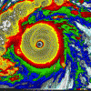
icebreaker5221 Posted July 31, 2013 Author Share Posted July 31, 2013 Gil starting to pop an eye, still looking very symmetric. Should be a hurricane soon. Link to comment Share on other sites More sharing options...
Superstorm93 Posted July 31, 2013 Share Posted July 31, 2013 Should be a hurricane by tonight EDIT: EP, 07, 2013073118, , BEST, 0, 137N, 1202W, 65, 992, HU Link to comment Share on other sites More sharing options...
phil882 Posted July 31, 2013 Share Posted July 31, 2013 Only a 5 knot increase in strength the next 48 hours... its like the NHC wants to take a hit on their intensity statistics for this system. Somewhere in the 85-100 knots range is more likely going to be this system's max intensity. At some point, you gotta realize taking SHIPS / LGEM verbatim is not always the best idea, and pay attention to those RI metrics which show a significant probability of RI! EDIT: After actually looking a little bit closer at some of the global models, its worth noting the ECMWF weakens the system almost immediately. Mike'v VP Kelvin wave filtered graphics also shows a strong suppressed KW phase approaching, which might both enhance substance and increase westerly vertical wind shear beyond what SHIPS had (which is based on the GFS). Given how small Gil is currently, even a minor change in the synoptic environment could cause harm. It makes a little more sense given these other variables that the NHC is remaining conservative. Link to comment Share on other sites More sharing options...
thewxmann Posted August 1, 2013 Share Posted August 1, 2013 It's already starting to weaken a little. Less symmetry than a few hours ago, and the eye is gone. Nonetheless, just as you say that Phil, NHC brings this up to 85kt now. You can almost feel from the tone of the discussions that the NHC doesn't really care about this system, though. Link to comment Share on other sites More sharing options...
icebreaker5221 Posted August 1, 2013 Author Share Posted August 1, 2013 I gotta say, I disagree with this guidance. Shear remains very low and SSTs will be at least 26 C through 120 h (and quite a bit warmer if stays even slightly south of the NHC track). There is some dry air to the north and south but with little shear, I don't see that much of it being ingested by the center of circulation. My forecast: still a hurricane at 120 h (Tue @ 12Z). Link to comment Share on other sites More sharing options...
phil882 Posted August 2, 2013 Share Posted August 2, 2013 I gotta say, I disagree with this guidance. Shear remains very low and SSTs will be at least 26 C through 120 h (and quite a bit warmer if stays even slightly south of the NHC track). There is some dry air to the north and south but with little shear, I don't see that much of it being ingested by the center of circulation. My forecast: still a hurricane at 120 h (Tue @ 12Z). ep072013_inten.png I agree... the ECMWF in particular is now going bonkers in the long range, with a rapidly intensifying storm beyond day 5. However, visible has left much to be desired today, with the inner core looking like it has been disrupted somewhat (perhaps by dry air making it into the core). In any event its looking far more likely that Gil will be with us for quite some time... in fact the ECMWF takes Gil south of Hawaii and continued westward as a definite storm at 240 hours (track similar to John 1994). Link to comment Share on other sites More sharing options...
Snow_Miser Posted August 2, 2013 Share Posted August 2, 2013 I agree... the ECMWF in particular is now going bonkers in the long range, with a rapidly intensifying storm beyond day 5. However, visible has left much to be desired today, with the inner core looking like it has been disrupted somewhat (perhaps by dry air making it into the core). In any event its looking far more likely that Gil will be with us for quite some time... in fact the ECMWF takes Gil south of Hawaii and continued westward as a definite storm at 240 hours (track similar to John 1991). Think you mean John of 1994 Link to comment Share on other sites More sharing options...
phil882 Posted August 2, 2013 Share Posted August 2, 2013 Think you mean John of 1994 Oops... shame on me for getting my years mixed up! This is what the ECMWF has at 180 hours: Link to comment Share on other sites More sharing options...
icebreaker5221 Posted August 2, 2013 Author Share Posted August 2, 2013 I agree... the ECMWF in particular is now going bonkers in the long range, with a rapidly intensifying storm beyond day 5. However, visible has left much to be desired today, with the inner core looking like it has been disrupted somewhat (perhaps by dry air making it into the core). In any event its looking far more likely that Gil will be with us for quite some time... in fact the ECMWF takes Gil south of Hawaii and continued westward as a definite storm at 240 hours (track similar to John 1994). Yeah, latest IR doesn't look too hot either. Not going to go back on my call yet. Also, Euro is intriguing, and doesn't show any significant intensification until 96+ h, so I'm not necessarily off-track already. Link to comment Share on other sites More sharing options...
phil882 Posted August 2, 2013 Share Posted August 2, 2013 Ugh... might have to eat crow on this one... it looks like Dorian did when it was being sheared last week . Another example of low-level flow outrunning the upper-level flow on tap. Link to comment Share on other sites More sharing options...
Santa Claus Posted August 2, 2013 Share Posted August 2, 2013 I am pretty new to this stuff but glancing at the infrared I'm not sure how I could distinguish Gil from the rest of the ITCZ convection parade. Just looks like a completely indiscriminate mass of thunderstorm activity, not a 70 mph storm. But that is why I am not paid the big bucks Link to comment Share on other sites More sharing options...
icebreaker5221 Posted August 4, 2013 Author Share Posted August 4, 2013 I am pretty new to this stuff but glancing at the infrared I'm not sure how I could distinguish Gil from the rest of the ITCZ convection parade. Just looks like a completely indiscriminate mass of thunderstorm activity, not a 70 mph storm. But that is why I am not paid the big bucks Wow, Gil just completely fell apart, despite only 3 kt of shear (per 00Z SHIPS analysis), 28.5 C SSTs, and a relatively moist environment. I wish I wasn't so busy right now with work and travel so I could try to figure out why Gil collapsed in an otherwise favorable environment. Perhaps there is just too much competition with nearby vorticity maxima and other general convection within the ITCZ all around Gil? Could be a fun case study. Link to comment Share on other sites More sharing options...
wxtrackercody Posted August 4, 2013 Share Posted August 4, 2013 Wow, Gil just completely fell apart, despite only 3 kt of shear (per 00Z SHIPS analysis), 28.5 C SSTs, and a relatively moist environment. I wish I wasn't so busy right now with work and travel so I could try to figure out why Gil collapsed in an otherwise favorable environment. Perhaps there is just too much competition with nearby vorticity maxima and other general convection within the ITCZ all around Gil? Could be a fun case study. According to Eric Blake on Twitter, SHIPS was analyzing wind shear too low. CIMSS maps revealed 20-25 knots of wind shear when it became to collapse. Link to comment Share on other sites More sharing options...
thewxmann Posted August 4, 2013 Share Posted August 4, 2013 Subsidence? Also, satellite images of Gil wreaked of mid-lvl shear issues post-peak. Link to comment Share on other sites More sharing options...
phil882 Posted August 4, 2013 Share Posted August 4, 2013 Subsidence from a CCKW? It was moving over right as the system started to collapse as it fought westerly shear. Link to comment Share on other sites More sharing options...
Mike.Ventrice Posted August 4, 2013 Share Posted August 4, 2013 Yeah Eric just emailed me- he's thinking the suppressed CCKW may have played a key role here with the weakening. According to my diagnostics, this suppressed CCKW phase was 3 sigma strong!!! #suppressedCCKWsmackdown But what follows the suppressed CCKW phase is its active phase... maybe we could get an Atlantic TC to spin up following the passage of the active phase in Week 1-2. Link to comment Share on other sites More sharing options...
Superstorm93 Posted August 4, 2013 Share Posted August 4, 2013 If Henriette takes the unlikely southern track like the HWRF has, then it shouldn't have a problem becoming a hurricane. Link to comment Share on other sites More sharing options...
icebreaker5221 Posted August 5, 2013 Author Share Posted August 5, 2013 Yeah Eric just emailed me- he's thinking the suppressed CCKW may have played a key role here with the weakening. According to my diagnostics, this suppressed CCKW phase was 3 sigma strong!!! #suppressedCCKWsmackdown But what follows the suppressed CCKW phase is its active phase... maybe we could get an Atlantic TC to spin up following the passage of the active phase in Week 1-2. Yeah, that looks like a very likely culprit, especially one so strong. Are those forecasts from the CFS or an empirical propagation approach? If that forecast is correct, it looks like the active phase of the Kelvin wave weakens quite a bit once it reaches the Atlantic. Link to comment Share on other sites More sharing options...
Mike.Ventrice Posted August 5, 2013 Share Posted August 5, 2013 Yeah, that looks like a very likely culprit, especially one so strong. Are those forecasts from the CFS or an empirical propagation approach? If that forecast is correct, it looks like the active phase of the Kelvin wave weakens quite a bit once it reaches the Atlantic. These forecasts are using the GFS operational (I know I will hopefully update them one day to an ensemble or CFS) to day 7, with linear extrapolation thereafter. So by Week 1-2, the CCKW will likely be weaker than what will verify, especially in Week 2. Link to comment Share on other sites More sharing options...
jordanwx Posted August 6, 2013 Share Posted August 6, 2013 These forecasts are using the GFS operational (I know I will hopefully update them one day to an ensemble or CFS) to day 7, with linear extrapolation thereafter. So by Week 1-2, the CCKW will likely be weaker than what will verify, especially in Week 2. If you could get the GEFS in there that would be awesome. It would also be nice to get other global models in the mix. ECMWF and UKMET are mostly restricted and the NAVGEM is mostly useless, but maybe you could get the CMC up? Link to comment Share on other sites More sharing options...
Santa Claus Posted August 6, 2013 Share Posted August 6, 2013 Yeah Eric just emailed me- he's thinking the suppressed CCKW may have played a key role here with the weakening. According to my diagnostics, this suppressed CCKW phase was 3 sigma strong!!! #suppressedCCKWsmackdown I'm a big fan of your research, don't debase it by Twitterizing it Link to comment Share on other sites More sharing options...
Yellow Evan Posted August 8, 2013 Share Posted August 8, 2013 Henritte is a Cat 2 now. and there is a code yellow and organge west of it. Models show that threatening Hawaii. Link to comment Share on other sites More sharing options...
Santa Claus Posted August 8, 2013 Share Posted August 8, 2013 Henriette looks awesome now, I hesitate to use the word but she looks annular. She's just a donut of convection. Might have a bit too much banding to actually be annular but the presentation on infrared looks awesome. Also looking at water vapor it seems like she's headed into a pretty moist environment so while she's probably peaked I'm curious to see how quickly she will fall apart. Link to comment Share on other sites More sharing options...
Ed Lizard Posted August 8, 2013 Share Posted August 8, 2013 Henriette looks awesome now, I hesitate to use the word but she looks annular. She's just a donut of convection. Might have a bit too much banding to actually be annular but the presentation on infrared looks awesome. Also looking at water vapor it seems like she's headed into a pretty moist environment so while she's probably peaked I'm curious to see how quickly she will fall apart. From what little I understand, the eyes are usually larger. But what appear to be spiral bands on initial inspection may be outflow channels. Worth watching. Always save a nice storm for posterity Link to comment Share on other sites More sharing options...

Recommended Posts
Archived
This topic is now archived and is closed to further replies.