Srain Posted May 29, 2013 Share Posted May 29, 2013 Link to comment Share on other sites More sharing options...
HurricaneJosh Posted May 29, 2013 Share Posted May 29, 2013 Someone should update the tagline: Hurricane Barbara making landfall or something like that. Link to comment Share on other sites More sharing options...
icebreaker5221 Posted May 29, 2013 Author Share Posted May 29, 2013 The Mexican radar imagery isn't aligning the echoes with the landmasses properly. This is not a vertical-tilt thing-- it's just a mistake. Yeah, I'm now convinced that the radar is off. While the location of the radar appears to be right, the entire frame appears to be rotated counter-clockwise about its origin from where it should be. Link to comment Share on other sites More sharing options...
Windspeed Posted May 29, 2013 Share Posted May 29, 2013 Yeah, I'm now convinced that the radar is off. While the location of the radar appears to be right, the entire frame appears to be rotated counter-clockwise about its origin from where it should be. Yes, I shouldn't have said the radar was inaccurate; rather, I should have said the overlay is inaccurate. The 60º line from site should actually be 90º. So when you're following the line on radar, just consider that directly east of the site for reference. This thing is still clearly offshore and intensifying. Perhaps Barbara makes landfall above minimal hurricane strength. Link to comment Share on other sites More sharing options...
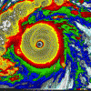
Ground Scouring Posted May 29, 2013 Share Posted May 29, 2013 Barbara looked to have a really tight, organized core at LF with a stadium effect developing in the eye as it crossed the coast. I would say that suggests the LF intensity was a bit higher than 65 kt--perhaps even near-Cat. 2 (80 kt), like Humberto 2007 in the Atlantic, in intensity. The microwave scan presents a TC with an eye-wall structure strikingly similar to that of Jova 2011 at LF, which Josh chased. (I know. ) It's also quite minute, with 'cane-force winds extending 25 mi from the small center. Note that potent SE quadrant making LF, which is why I made the comparison between Barbara and Jova. I'm impressed. What a *hawt* little micro-cane...I could almost mistake it for a full-blown major. Our easternmost landfalling 'cane in the EPAC is such a pretty sight, from a structural perspective. Link to comment Share on other sites More sharing options...
wxmx Posted May 29, 2013 Share Posted May 29, 2013 Barbara became the easternmost hurricane landfall in the EPac and the 2nd earliest hurricane landfall. Link to comment Share on other sites More sharing options...
wxmx Posted May 29, 2013 Share Posted May 29, 2013 Data from automated station in the Chiapas coast (real-time): Wind gust (km/h) Arghhhh...all the data from the stations near the landfall rolled back to May 20th...I couldn't download more graphics or the text data...I remember the pressure was rapidly falling and it was around 997mb near Tonala, right at the coast. Link to comment Share on other sites More sharing options...
wxmx Posted May 29, 2013 Share Posted May 29, 2013 Oh, I had a tab open with the text data W direction Wind speed Gust Temp Pressure 29/05/2013 15:15 112 108 20.50 33.90 24.5 100 1008.5 0.0 29/05/2013 15:30 109 109 19.30 32.10 24.0 100 1008.5 0.0 29/05/2013 15:45 102 102 17.10 41.30 23.7 100 1008.3 0.0 29/05/2013 16:00 104 101 23.60 38.50 23.6 100 1008.2 0.0 29/05/2013 16:15 89 98 14.90 32.70 23.4 100 1008.0 0.0 29/05/2013 16:30 103 73 21.10 37.90 23.4 100 1008.0 0.0 29/05/2013 16:45 98 106 17.80 40.20 23.5 100 1007.6 0.0 29/05/2013 17:00 92 104 15.80 30.40 23.4 100 1006.8 0.0 29/05/2013 17:15 106 99 23.00 39.00 23.5 100 1006.9 0.3 29/05/2013 17:30 109 106 28.20 54.60 23.3 100 1006.7 0.0 29/05/2013 17:45 108 109 26.90 45.40 23.0 100 1006.3 0.0 29/05/2013 18:00 103 111 24.60 47.10 23.0 100 1006.1 0.0 29/05/2013 18:15 101 101 28.30 48.20 22.9 100 1005.4 0.0 29/05/2013 18:30 100 98 31.30 54.60 23.1 100 1004.7 0.0 29/05/2013 18:45 94 92 34.50 55.70 23.1 100 1003.1 0.0 29/05/2013 19:00 95 104 34.50 63.20 23.2 100 1002.0 0.0 29/05/2013 19:15 96 104 37.30 66.10 23.1 100 1000.5 0.0 29/05/2013 19:30 101 110 42.40 77.00 22.9 100 999.1 0.0 29/05/2013 19:45 110 111 52.40 84.50 23.2 100 997.6 0.3 Link to comment Share on other sites More sharing options...
Ground Scouring Posted May 29, 2013 Share Posted May 29, 2013 Oh, I had a tab open with the text data W direction Wind speed Gust Temp Pressure 29/05/2013 15:15 112 108 20.50 33.90 24.5 100 1008.5 0.0 29/05/2013 15:30 109 109 19.30 32.10 24.0 100 1008.5 0.0 29/05/2013 15:45 102 102 17.10 41.30 23.7 100 1008.3 0.0 29/05/2013 16:00 104 101 23.60 38.50 23.6 100 1008.2 0.0 29/05/2013 16:15 89 98 14.90 32.70 23.4 100 1008.0 0.0 29/05/2013 16:30 103 73 21.10 37.90 23.4 100 1008.0 0.0 29/05/2013 16:45 98 106 17.80 40.20 23.5 100 1007.6 0.0 29/05/2013 17:00 92 104 15.80 30.40 23.4 100 1006.8 0.0 29/05/2013 17:15 106 99 23.00 39.00 23.5 100 1006.9 0.3 29/05/2013 17:30 109 106 28.20 54.60 23.3 100 1006.7 0.0 29/05/2013 17:45 108 109 26.90 45.40 23.0 100 1006.3 0.0 29/05/2013 18:00 103 111 24.60 47.10 23.0 100 1006.1 0.0 29/05/2013 18:15 101 101 28.30 48.20 22.9 100 1005.4 0.0 29/05/2013 18:30 100 98 31.30 54.60 23.1 100 1004.7 0.0 29/05/2013 18:45 94 92 34.50 55.70 23.1 100 1003.1 0.0 29/05/2013 19:00 95 104 34.50 63.20 23.2 100 1002.0 0.0 29/05/2013 19:15 96 104 37.30 66.10 23.1 100 1000.5 0.0 29/05/2013 19:30 101 110 42.40 77.00 22.9 100 999.1 0.0 29/05/2013 19:45 110 111 52.40 84.50 23.2 100 997.6 0.3 So was the maximum 52-kt ESE at 19:45 local time a one-minute value in MX too? Tonalá is just about 15 mi ENE of the landfall location, and the LF pressure was ~8 mb lower, so the pressure gradient was probably about 10 mb in 10 mi. Impressive! Link to comment Share on other sites More sharing options...
HurricaneJosh Posted May 29, 2013 Share Posted May 29, 2013 Barbara became the easternmost hurricane landfall in the EPac and the 2nd earliest hurricane landfall. Correct. Cool factoid: if it becomes a hurricane and stays on the forecast track, it would be the furthest-east hurricane landfall on record in this basin. Link to comment Share on other sites More sharing options...
Ground Scouring Posted May 29, 2013 Share Posted May 29, 2013 Barbara looked to have a really tight, organized core at LF with a stadium effect developing in the eye as it crossed the coast. I would say that suggests the LF intensity was a bit higher than 65 kt--perhaps even near-Cat. 2 (80 kt), like Humberto 2007 in the Atlantic, in intensity. The microwave scan presents a TC with an eye-wall structure strikingly similar to that of Jova 2011 at LF, which Josh chased. (I know. ) It's also quite minute, with 'cane-force winds extending 25 mi from the small center. Note that potent SE quadrant making LF, which is why I made the comparison between Barbara and Jova. I'm impressed. What a *hawt* little micro-cane...I could almost mistake it for a full-blown major. Our easternmost landfalling 'cane in the EPAC is such a pretty sight, from a structural perspective. *Hawt shots for Josh* Link to comment Share on other sites More sharing options...
HurricaneJosh Posted May 29, 2013 Share Posted May 29, 2013 *Hawt shots for Josh* Thanks, snowflake-- I appreciate it. I actually saved these into my weather-porn folder. Link to comment Share on other sites More sharing options...
wxmx Posted May 29, 2013 Share Posted May 29, 2013 So was the maximum 52-kt ESE at 19:45 local time a one-minute value in MX too? Tonalá is just about 15 mi ENE of the landfall location, and the LF pressure was ~8 mb lower, so the pressure gradient was probably about 10 mb in 10 mi. Impressive! Thats UTC...2:45 local time...and that's km/h...that station is about 15mi SW of Tonala, at the coast... ...and just about now, the stations came back to life: 29/05/2013 19:45 110 111 52.40 84.50 23.2 100 997.6 0.3 29/05/2013 20:00 127 108 56.20 106.40 23.8 100 996.5 0.0 29/05/2013 20:15 141 144 56.50 93.70 23.8 100 995.3 0.0 29/05/2013 20:30 177 185 59.50 111.00 23.5 100 995.8 0.3 29/05/2013 20:45 183 195 67.30 120.20 23.3 100 998.2 0.3 Link to comment Share on other sites More sharing options...
wxmx Posted May 29, 2013 Share Posted May 29, 2013 Link to MX automated stations http://smn.cna.gob.mx/emas/ Link to comment Share on other sites More sharing options...
icebreaker5221 Posted May 29, 2013 Author Share Posted May 29, 2013 Thats UTC...2:45 local time...and that's km/h...that station is about 15mi SW of Tonala, at the coast... ...and just about now, the stations came back to life: 29/05/2013 19:45 110 111 52.40 84.50 23.2 100 997.6 0.3 29/05/2013 20:00 127 108 56.20 106.40 23.8 100 996.5 0.0 29/05/2013 20:15 141 144 56.50 93.70 23.8 100 995.3 0.0 29/05/2013 20:30 177 185 59.50 111.00 23.5 100 995.8 0.3 29/05/2013 20:45 183 195 67.30 120.20 23.3 100 998.2 0.3 So now it looks like 67 km/h sustained, gusts to 120. Not bad. Official landfall location was 20 mi w of Tonala, so if that station was 15 mi SW of Tonala, it was basically in the best spot possible to feel the right-front eyewall. Link to comment Share on other sites More sharing options...
wxmx Posted May 29, 2013 Share Posted May 29, 2013 And BTW, sustained wind is for a 10min period, I think Edit: so it roughly translates to 40G65 Link to comment Share on other sites More sharing options...
Ground Scouring Posted May 30, 2013 Share Posted May 30, 2013 Interestingly, the vortex seems to be maintaining intensity while actually tightening up over land. Currently the center is traversing a relatively low area but is about to enter mountainous peaks +2,000 ft. above means sea level. Does the increasing altitude, besides orographic lifting and frictional convergence, affect the lapse rate of the convection in such a way that it facilitates a tightening/strengthening of the low-level vorticity center? Barbara still looks remarkably organized, if not more so, over land: Link to comment Share on other sites More sharing options...
wxmx Posted May 30, 2013 Share Posted May 30, 2013 Barbara was strengthening upon landfall, so it's probably some inertia with a decent upper level support....southern half outflow is pretty nice, and shear from the N still hasn't disrupted the center. Terrain and stronger shear will probably take it's toll soon. Link to comment Share on other sites More sharing options...
wxmx Posted May 30, 2013 Share Posted May 30, 2013 Making calculations and looking at the data (sustained winds never abated until the center was quite far), the center was quite small, and at least 10 mi to the west of the PREDON automated station (which is no more than 10mi to the SW of Tonala, looking at it closely). For posterity sake, this is the barogram: Link to comment Share on other sites More sharing options...
wxmx Posted May 30, 2013 Share Posted May 30, 2013 Station at Arriaga, about 15-20mi to the WNW of Tonala and 10-15mi from the coast was closer to the eye, but it missed it too. It reported 36G56, which is pretty decent. The pressure sensor looks off by 6-7mb comparing it to PREDON...which suggests the eye might have been 990mb or maybe a little below that Link to comment Share on other sites More sharing options...
wxtrackercody Posted May 30, 2013 Share Posted May 30, 2013 The storm is retaining its impressive structure but the intensity of the convection has been on the decline over the past few hours. Its slow movement and already weakened state means it's probably not going to survive the crossing (not that ti was likely to begin with), but it was fun to track anyways. Definitely one of my biggest forecast busts...I won't be so fast to jump on short-term satellite trends next time, lol. Link to comment Share on other sites More sharing options...
wxmx Posted May 30, 2013 Share Posted May 30, 2013 Station at Arriaga, about 15-20mi to the WNW of Tonala and 10-15mi from the coast was closer to the eye, but it missed it too. It reported 36G56, which is pretty decent. The pressure sensor looks off by 6-7mb comparing it to PREDON...which suggests the eye might have been 990mb or maybe a little below that CS19pbar.gif Pressure for the automated stations is not calibrated for mean sea level. The Arriaga station is at 62m (mean altitude for the town is 56m), so correcting it for the altitude, it results in a 989mb MSLP Barbara has already gone past the roughest terrain (mostly missed Cerro Atravesado to the east), and it still looks decent. It will probably get it's feet wet by noon tomorrow. Shear looks strong, so if it loses it's LLC, I will attribute it more to shear than land interaction. Link to comment Share on other sites More sharing options...
HurricaneJosh Posted May 30, 2013 Share Posted May 30, 2013 Barbara looked to have a really tight, organized core at LF with a stadium effect developing in the eye as it crossed the coast. I would say that suggests the LF intensity was a bit higher than 65 kt--perhaps even near-Cat. 2 (80 kt), like Humberto 2007 in the Atlantic, in intensity. The microwave scan presents a TC with an eye-wall structure strikingly similar to that of Jova 2011 at LF, which Josh chased. (I know. ) It's also quite minute, with 'cane-force winds extending 25 mi from the small center. Note that potent SE quadrant making LF, which is why I made the comparison between Barbara and Jova. I'm impressed. What a *hawt* little micro-cane...I could almost mistake it for a full-blown major. Our easternmost landfalling 'cane in the EPAC is such a pretty sight, from a structural perspective. Hey, snowflake-- just read this whole post (finally), and I agree that Barbie was pretty hawt and it did have have some structural similarities with Jova. It is a nice way to start the season. Link to comment Share on other sites More sharing options...
HurricaneJosh Posted May 30, 2013 Share Posted May 30, 2013 Another random, interesting piece of trivia: Barbie is the only known hurricane landfall in the Mexican state of Chiapas. Link to comment Share on other sites More sharing options...
wxmx Posted May 30, 2013 Share Posted May 30, 2013 It's now on smooth terrain in the state of Tabasco. Barbara should be in the Gulf in around 6hrs at most. Link to comment Share on other sites More sharing options...
icebreaker5221 Posted May 30, 2013 Author Share Posted May 30, 2013 It's now on smooth terrain in the state of Tabasco. Barbara should be in the Gulf in around 6hrs at most. Right now the remnants of Barbara are just entering the Gulf. Low level circulation definitely still evident, but without any deep convection, it's going to be a slave to the low-level steering flow. No longer shielded by topography, she's going to feel the full brunt of the easterlies which are quite strong right now. Whatever is left of Barbara should plow into Veracruz today or tonight. Link to comment Share on other sites More sharing options...
Ground Scouring Posted May 30, 2013 Share Posted May 30, 2013 NHC says Barbara is dead, yet I clearly see a closed, albeit broad and ill-defined, LLC in the S Bay of Campeche, within which are embedded many smaller vortices. Link to comment Share on other sites More sharing options...
Srain Posted June 7, 2013 Share Posted June 7, 2013 Cosme, is that you? Link to comment Share on other sites More sharing options...
HurricaneJosh Posted June 8, 2013 Share Posted June 8, 2013 Noice. Link to comment Share on other sites More sharing options...
Srain Posted June 11, 2013 Share Posted June 11, 2013 New Lemon in the EPAC Link to comment Share on other sites More sharing options...

Recommended Posts
Archived
This topic is now archived and is closed to further replies.