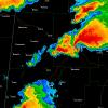
cyclone77 Posted April 9, 2012 Share Posted April 9, 2012 From roughly a half an hour ago. Dual-pol variables help to visualize two updrafts just before the splitting occurs. ZDR represents the rough shape of the target, and updrafts contain liquid water in large concentrations (which should show up as positive ZDR). Two areas of positive ZDR show up, representing the two updrafts prior to the split (one north of Buffalo and the other southwest). The idea being that in the future, as we get better at recognizing these features. Two polygons could be issued, one for the left mover and one for the right. As the right mover is already diving hard out of about 300 degrees, whereas the first polygon was for a storm motion near 250. Very nice! This season will definitely be a learning experience as we get more and more opportunities to use dual-pol in these situations. Link to comment Share on other sites More sharing options...
OceanStWx Posted April 9, 2012 Share Posted April 9, 2012 Big time echo overhang on that cell. Surely producing significant hail, however the inflow is about to be disturbed by the cells to the southwest. Probably going to limit tornado potential for at least the next several volume scans. Link to comment Share on other sites More sharing options...
cyclone77 Posted April 9, 2012 Share Posted April 9, 2012 About 100kts g2g in the 9000-13000ft range. Spinning like crazy aloft. Link to comment Share on other sites More sharing options...
OceanStWx Posted April 9, 2012 Share Posted April 9, 2012 About 100kts g2g in the 9000-13000ft range. Spinning like crazy aloft. The storm farther southwest, northwest of Woodward, actually has a very well defined mid level meso too. Has just as much potential I would think. Maybe not as close to the warm front, but probably has outflow from the northern cell to act as a pseudo-warm front. Link to comment Share on other sites More sharing options...
SouthernNJ Posted April 9, 2012 Share Posted April 9, 2012 The storm approaching Woodward is potentially concerning, because if it strengthens, it will move into a populated area. Link to comment Share on other sites More sharing options...
andyhb Posted April 9, 2012 Share Posted April 9, 2012 Very strong rotation on the Woodward cell now. Link to comment Share on other sites More sharing options...
Buckeye05 Posted April 9, 2012 Share Posted April 9, 2012 They are both starting to get that "look". Link to comment Share on other sites More sharing options...
OceanStWx Posted April 9, 2012 Share Posted April 9, 2012 They are right on the nose of the theta-e ridge, with a really sharply defined boundary providing plenty of low level vorticity. Couple that with steep low level lapse rates you have enough 0-3 km CAPE to stretch that in the horizontal. Link to comment Share on other sites More sharing options...
Buckeye05 Posted April 9, 2012 Share Posted April 9, 2012 Very strong rotation on the Woodward cell now. I think it's fairly elevated though. Link to comment Share on other sites More sharing options...
Superstorm93 Posted April 9, 2012 Share Posted April 9, 2012 Very respectable updraft now... BR/CC Link to comment Share on other sites More sharing options...
David Reimer Posted April 9, 2012 Share Posted April 9, 2012 The tornadic potential with the two supercells near Woodward will depend greatly on their potential to contain surface outflow. So far I have not seen any reports of defined low level circulations being reported by spotters. Remember that the VNX radar is looking upwards of 8,000 feet. Link to comment Share on other sites More sharing options...
cyclone77 Posted April 9, 2012 Share Posted April 9, 2012 At 2135 KWWR has south-southeast 36, gusting to 44mph. Nice surface inflow into that Woodward cell. Link to comment Share on other sites More sharing options...
Thundersnow12 Posted April 9, 2012 Share Posted April 9, 2012 via Timmer's photo the storm near Woodward looks a bit high based still with attempt at a clear slot. Link to comment Share on other sites More sharing options...
Superstorm93 Posted April 9, 2012 Share Posted April 9, 2012 The tornadic potential with the two supercells near Woodward will depend greatly on their potential to contain surface outflow. So far I have not seen any reports of defined low level circulations being reported by spotters. Remember that the VNX radar is looking upwards of 8,000 feet. Not if your using DDC, Link to comment Share on other sites More sharing options...
OceanStWx Posted April 9, 2012 Share Posted April 9, 2012 At 2135 KWWR has south-southeast 36, gusting to 44mph. Nice surface inflow into that Woodward cell. Hearing reports of a lot of dust being loft by the inflow, and CC bears that out with low values in the inflow region. Link to comment Share on other sites More sharing options...
cyclone77 Posted April 9, 2012 Share Posted April 9, 2012 110kt g2g west-northwest of Woodward at around 6500ft. Link to comment Share on other sites More sharing options...
OceanStWx Posted April 9, 2012 Share Posted April 9, 2012 via Timmer's photo the storm near Woodward looks a bit high based still with attempt at a clear slot. LCLs should lower quickly as it heads east though. Link to comment Share on other sites More sharing options...
andyhb Posted April 9, 2012 Share Posted April 9, 2012 Jeromy Carter is on it and yes it looks a bit high based right now for potential tornadic development, although i have seen scud rapidly rising into the base several times. Link to comment Share on other sites More sharing options...
David Reimer Posted April 9, 2012 Share Posted April 9, 2012 Not if your using DDC, DDC is further away from the Woodward storm then Vance. Link to comment Share on other sites More sharing options...
OceanStWx Posted April 9, 2012 Share Posted April 9, 2012 110kt g2g west-northwest of Woodward at around 6500ft. That kind of meso has to be producing something larger than golf balls. I would say we're pushing tennis balls at this point. Link to comment Share on other sites More sharing options...
Thundersnow12 Posted April 9, 2012 Share Posted April 9, 2012 0450 PM HAIL 6 NW WOODWARD 36.50N 99.47W 04/09/2012 E2.25 INCH WOODWARD OK PUBLIC 0452 PM HAIL 5 N WOODWARD 36.51N 99.39W 04/09/2012 E2.50 INCH WOODWARD OK TRAINED SPOTTER Link to comment Share on other sites More sharing options...
Superstorm93 Posted April 9, 2012 Share Posted April 9, 2012 Lots of reports of hail around 2.5" falling under these cells. Link to comment Share on other sites More sharing options...
cyclone77 Posted April 9, 2012 Share Posted April 9, 2012 That kind of meso has to be producing something larger than golf balls. I would say we're pushing tennis balls at this point. Yeah, and that echo overhang you mentioned earlier has been SICK. Link to comment Share on other sites More sharing options...
OceanStWx Posted April 9, 2012 Share Posted April 9, 2012 0450 PM HAIL 6 NW WOODWARD 36.50N 99.47W 04/09/2012 E2.25 INCH WOODWARD OK PUBLIC 0452 PM HAIL 5 N WOODWARD 36.51N 99.39W 04/09/2012 E2.50 INCH WOODWARD OK TRAINED SPOTTER Tennis balls FTW! Link to comment Share on other sites More sharing options...
andyhb Posted April 9, 2012 Share Posted April 9, 2012 Not sure which cell the Quad County Chasers are looking at (they're in between both), but they have a wall cloud on their stream. Link to comment Share on other sites More sharing options...
David Reimer Posted April 9, 2012 Share Posted April 9, 2012 My business partner (Connor McCrorey) reported baseballs (2.75 Inches) about ten minutes ago. Link to comment Share on other sites More sharing options...
Thundersnow12 Posted April 9, 2012 Share Posted April 9, 2012 nice looking TBSS on the Woodward storm now. Link to comment Share on other sites More sharing options...
andyhb Posted April 9, 2012 Share Posted April 9, 2012 Rapid rotation on Jeromy's cam now. Link to comment Share on other sites More sharing options...
Superstorm93 Posted April 9, 2012 Share Posted April 9, 2012 Link to comment Share on other sites More sharing options...
SquatchinNY Posted April 9, 2012 Author Share Posted April 9, 2012 ... Link to comment Share on other sites More sharing options...

Recommended Posts
Archived
This topic is now archived and is closed to further replies.