OceanStWx Posted April 9, 2012 Share Posted April 9, 2012 SPC mesoanalysis actually shows the cap weakening right in the vicinity of the Beaver County Cu field. Link to comment Share on other sites More sharing options...
tornadotony Posted April 9, 2012 Share Posted April 9, 2012 SPC mesoanalysis actually shows the cap weakening right in the vicinity of the Beaver County Cu field. This could be one of those days with one localized nasty surprise right along the warm front. Link to comment Share on other sites More sharing options...
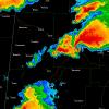
Thundersnow12 Posted April 9, 2012 Share Posted April 9, 2012 The Cu field is expanding in the western portion of the MCD area, in the Oklahoma panhandle (as mentioned in the text). The environment is pretty favorable across Harper, Ellis, and Woodward counties. But narrow corridor as SPC mentions. very impressive low/mid level lapse rates to work with. Wish i could be down there chasing this week. Link to comment Share on other sites More sharing options...
OceanStWx Posted April 9, 2012 Share Posted April 9, 2012 If I had to guess, I would say something will go up first in Harper County. Pretty strong, localized moisture convergence and right on the nose of the low level theta-e ridge. And Tony speaking of the localized surprise, storm motions should be roughly parallel to that warm frontal boundary. So any storm that can attach to it will maximize all that low level vorticity. Link to comment Share on other sites More sharing options...
SquatchinNY Posted April 9, 2012 Author Share Posted April 9, 2012 . http://www.spc.noaa.gov/products/watch/ww0151.html Link to comment Share on other sites More sharing options...
OceanStWx Posted April 9, 2012 Share Posted April 9, 2012 very impressive low/mid level lapse rates to work with. Wish i could be down there chasing this week. Big time mid level lapse rates, helping to contribute to around 600 J/kg CAPE in the hail growth zone already. Freezing levels are on the high side, but there should be some awfully large hail out there today. Link to comment Share on other sites More sharing options...
OceanStWx Posted April 9, 2012 Share Posted April 9, 2012 Cu looks a lot more congested in northwestern Harper County now. Forcing has been rather stationary there for the last couple of hours, I expected it's ready to go up soon. Link to comment Share on other sites More sharing options...
cyclone77 Posted April 9, 2012 Share Posted April 9, 2012 23kft tops showing up just west of Buffalo now. Link to comment Share on other sites More sharing options...
OceanStWx Posted April 9, 2012 Share Posted April 9, 2012 That area of Cu at the beginning of the Oklahoma panhandle has been nearly stationary for the last hour or so, and is definitely growing in size with the latest images. Link to comment Share on other sites More sharing options...
Thundersnow12 Posted April 9, 2012 Share Posted April 9, 2012 something i put together pretty quickly. I'd probably be somewhere along US 64 between Buffalo and Alva in northwest OK Link to comment Share on other sites More sharing options...
SquatchinNY Posted April 9, 2012 Author Share Posted April 9, 2012 23kft tops showing up just west of Buffalo now. Link to comment Share on other sites More sharing options...
cyclone77 Posted April 9, 2012 Share Posted April 9, 2012 Over 34kft now. Looks like definite initiation. Link to comment Share on other sites More sharing options...
SquatchinNY Posted April 9, 2012 Author Share Posted April 9, 2012 http://www.spc.noaa.gov/products/md/md0479.html Link to comment Share on other sites More sharing options...
Buckeye05 Posted April 9, 2012 Share Posted April 9, 2012 Amarillo storm already showing a hint of rotation. Link to comment Share on other sites More sharing options...
SquatchinNY Posted April 9, 2012 Author Share Posted April 9, 2012 http://www.spc.noaa.gov/products/watch/ww0152.html Link to comment Share on other sites More sharing options...
#NoPoles Posted April 9, 2012 Share Posted April 9, 2012 jeez, looks like NM is getting some of the best action, atm Link to comment Share on other sites More sharing options...
cyclone77 Posted April 9, 2012 Share Posted April 9, 2012 Buffalo cell may be about to split. Link to comment Share on other sites More sharing options...
SquatchinNY Posted April 9, 2012 Author Share Posted April 9, 2012 Buffalo cell 05 WUUS54 KOUN 092039 SVROUN OKC059-151-092130- /O.NEW.KOUN.SV.W.0064.120409T2039Z-120409T2130Z/ BULLETIN - IMMEDIATE BROADCAST REQUESTED SEVERE THUNDERSTORM WARNING NATIONAL WEATHER SERVICE NORMAN OK 339 PM CDT MON APR 9 2012 THE NATIONAL WEATHER SERVICE IN NORMAN HAS ISSUED A * SEVERE THUNDERSTORM WARNING FOR... NORTHEASTERN HARPER COUNTY IN NORTHWESTERN OKLAHOMA... NORTHWESTERN WOODS COUNTY IN NORTHWESTERN OKLAHOMA... * UNTIL 430 PM CDT * AT 337 PM CDT...NATIONAL WEATHER SERVICE DOPPLER RADAR INDICATED A SEVERE THUNDERSTORM CAPABLE OF PRODUCING HALF DOLLAR SIZE HAIL AND DAMAGING WINDS IN EXCESS OF 60 MPH. THIS STORM WAS LOCATED NEAR SELMAN...MOVING NORTHEAST AT 30 MPH. * LOCATIONS IMPACTED INCLUDE... SELMAN. PRECAUTIONARY/PREPAREDNESS ACTIONS... MOVE INSIDE A STURDY BUILDING UNTIL THE STORM HAS PASSED. && A TORNADO WATCH REMAINS IN EFFECT UNTIL 900 PM CDT MONDAY EVENING FOR SOUTHWESTERN KANSAS AND NORTHWESTERN OKLAHOMA. LAT...LON 3690 9894 3687 9897 3674 9952 3678 9955 3697 9964 3700 9951 3700 9902 TIME...MOT...LOC 2037Z 246DEG 25KT 3688 9952 $$ WR Link to comment Share on other sites More sharing options...
andyhb Posted April 9, 2012 Share Posted April 9, 2012 Rapidly intensifying per latest reflectivity scan. Link to comment Share on other sites More sharing options...
aurora Posted April 9, 2012 Share Posted April 9, 2012 Cell is definitely trying to split. Link to comment Share on other sites More sharing options...
cyclone77 Posted April 9, 2012 Share Posted April 9, 2012 Now that the split is complete watch that area southeast of Buffalo. Link to comment Share on other sites More sharing options...
SouthernNJ Posted April 9, 2012 Share Posted April 9, 2012 Both storms have some circulation now. Link to comment Share on other sites More sharing options...
cyclone77 Posted April 9, 2012 Share Posted April 9, 2012 Interesting BWER on the 1.8 and 2.4 degree tilts southeast of Buffalo. Link to comment Share on other sites More sharing options...
SquatchinNY Posted April 9, 2012 Author Share Posted April 9, 2012 Interesting BWER on the 1.8 and 2.4 degree tilts southeast of Buffalo. BWER? Link to comment Share on other sites More sharing options...
andyhb Posted April 9, 2012 Share Posted April 9, 2012 Excellent mid level meso on that cell. BWER means "Bounded Weak Echo Region", where the reflectivity wraps around the inflow notch fully (creating donut hole feature on the reflectivity display), indicating strong rotation. Link to comment Share on other sites More sharing options...
OceanStWx Posted April 9, 2012 Share Posted April 9, 2012 Buffalo cell may be about to split. From roughly a half an hour ago. Dual-pol variables help to visualize two updrafts just before the splitting occurs. ZDR represents the rough shape of the target, and updrafts contain liquid water in large concentrations (which should show up as positive ZDR). Two areas of positive ZDR show up, representing the two updrafts prior to the split (one north of Buffalo and the other southwest). The idea being that in the future, as we get better at recognizing these features. Two polygons could be issued, one for the left mover and one for the right. As the right mover is already diving hard out of about 300 degrees, whereas the first polygon was for a storm motion near 250. Link to comment Share on other sites More sharing options...
cyclone77 Posted April 9, 2012 Share Posted April 9, 2012 BWER? Bounded Weak Echo Region. Basically a hole in the precip, which can indicate the updraft region aloft. Link to comment Share on other sites More sharing options...
andyhb Posted April 9, 2012 Share Posted April 9, 2012 TornadoTitans getting hit with golf ball/walnut sized hail currently. Link to comment Share on other sites More sharing options...
cyclone77 Posted April 9, 2012 Share Posted April 9, 2012 80+kt g2g couplet on the 0.9 tilt. That's at around 9000'. Link to comment Share on other sites More sharing options...
aurora Posted April 9, 2012 Share Posted April 9, 2012 From roughly a half an hour ago. Dual-pol variables help to visualize two updrafts just before the splitting occurs. ZDR represents the rough shape of the target, and updrafts contain liquid water in large concentrations (which should show up as positive ZDR). Two areas of positive ZDR show up, representing the two updrafts prior to the split (one north of Buffalo and the other southwest). The idea being that in the future, as we get better at recognizing these features. Two polygons could be issued, one for the left mover and one for the right. As the right mover is already diving hard out of about 300 degrees, whereas the first polygon was for a storm motion near 250. Informative post. Thanks for sharing. I'll gladly drop a bit of extra money to get dual-pol on GRLevel3, once it becomes available. Link to comment Share on other sites More sharing options...

Recommended Posts
Archived
This topic is now archived and is closed to further replies.