
Search the Community
Showing results for tags 'Wind'.
Found 10 results
-
Will we see our first heatwave? Severe weather? Or just a continuation of average to below average precip, above average temps and windy conditions?
-
 Different than the refresher powdery event of Sat Feb 17, and this past Tuesdays Feb 13 wetter snowstorm, it still has possibilities for adding to our winter snow totals with modeled "potential" for half a foot or more for the I84 corridor inclusive of the Poconos-extreme nw NJ interior sections se NYS-CT. Possibilities even exist for an inch or four down to I95 and NYC though for now, odds are less. This could be one warmer more rainy event the 22nd and then a following rapidly intensifying coastal storm Fri-Sat the 23rd-24th. As generally usual higher terrain-inland best chance for snow. A strong short wave in the eastern Pacific this weekend will move through the southwest USA early this coming week and probably be ingested into a series of northern stream Canadian short eaves that dive southeast into Midwest and form a sharp amplifying trough over the northeast USA by next weekend. Details tbd. This probably will be of NYC subforum interest for some of us the next few days as winter potential refuses to go away. Added 10 to 1 SLR, 24 hour 00z/17 global ensembles and the NWS 04z/17 very low chance 3+" snow D6-7, to look back upon when whatever transpires. Title tightening up and downgrade update at 537AM/20. Verification attached for a failed event- useless thread. Numerous traces of sleet -snow-rain mix I84 into NNJ 3P/22-9A/23 but modeled short waves remained separate with one tracking across se Canada and the other actually trailed and dropped down through the Carolines. Was over early per the poster comments.
 -
Hi everyone! Just wanted to get everyone's opinion on whether we could see wind speeds meeting Wind Advisory OR High Wind Warning criteria in portions of SE KY starting Monday night or Tuesday.
-
The downward slide into winter begins. Post your Obs/Discussions here.
-
 Since we do have a variety of forum posters in areas that will see snow/sleet/ZR - at least initially and on the backend, plus there is a flood threat, along with some potential advisory-level winds and possibly record breaking cold, decided to go ahead and make an obs thread. Currently misty and mostly virga and 36 with dp 32 here in NW Philly.
 -
Well, we are just one season away from winter. Nice to have a respite from the heat this week as the remnants of Ida depart the area. Thoughts and prayers for all of those affected by the hurricane along the Gulf Coast. Rainfall along the far eastern valley has been steady but reasonable - more as you go west I am nearly certain. This morning features light rain/drizzle and very low cloud decks. Lows in the northern valley are supposed to get into the 50s during the next few nights, and that is welcome news! Saw the first evidence of maples beginning to change color this morning. There is this one maple in our neighborhood which always changes first. Some of the dogwoods are beginning to show red in their leaves. Sycamores along the river are showing some yellow. For sure, some of that could be heat stress. Well, it is the first day of meteorological fall. I suspect this season will feature a quick snap to winter time temps late in the season. I am thinking warm early-mid fall, and then a sudden flip to cold. Somebody please fire-up an obs thread and also a banter thread for fall.
-
I’ve seen discussion in multiple threads, so here’s one for the storm. Should be a good widespread rain across a lot of the area. Tropical storm wind gusts working up the coast. Should be some gusty winds with whatever remains of the core as it moves through the Carolinas and into Virginia. Tomorrow afternoon could feature a tornado threat from the SC low country in NC coastal plain
- 28 replies
-
- 2
-

-
- elsa
- tropical storm
- (and 3 more)
-
Low pressure in the Virginia's late Wednesday will get picked up by an intensifying short wave moving east across the Mid Atlantic states Thursday and become a pretty good sized nor'easter as it departs the mid Atlantic coast Thursday afternoon. Does development occur fast enough to bring significant wind driven snow to a part of the NYC forum (rain or snow LI/NJ coast?)? 12z/23 GEFS is fairly robust on qpf, but further south than it's 00z/23 version, while 12z/23 EPS and GEPS are indicating too little too late. One small caveat: the low levels should remain fairly moist after the Tuesday - Tuesday night ( 26th) event (whatever it is) and there may be some advance snow or snow grains/freezing drizzle/drizzle late Wednesday or Wednesday night, in part related to leftover moisture and some sfc convergence. That too is an unknown. Added the WPC day shift forecast qpf and chance of 3+" of snow (darker green). Will update Monday the 25th, when some of the nor'easter threat to our area has resolved itself. Also added the NAEFS qpf... seems a little high near and north of I80 but it could happen. Also added the 12z/23 GEFS 500MB spaghetti for 12z/Thursday.
-
January 14/16th Snow event, Ocean Effect Snows
USCAPEWEATHERAF posted a blog entry in Once a legend always a legend
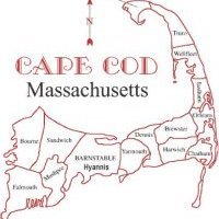
My next post is about the potential snows from Saturday evening through Thursday morning. Models are in general agreement that the potentials for Ocean Effect Snow from Sunday through Tuesday and then storm produced snows from Wednesday through Thursday due to a coastal storm is on the table. However, this post will solely focus on the Ocean Effect Snow potentials. First is the event Sunday through Monday. Mesoscale WRF-NMM and WRF-ARW both support a single band of ocean effect snowfall impacting the region of Cape Cod from Hyannis to Chatham and Provincetown on Northerly winds from 900mb to the surface, which means a single convergence band is more likely than multiple bands of snow which are less intense. These two models keep the band over this region from about 12z Sunday to 00z Monday or later, that is at least 12 hours or more of heavy snowfall over this area of the outer cape, this could produce more than 6" of snow, we will have to see the next few runs until the event starts and then diagnose the real short range models and what they produce. For now the potential exists of a few inches to as much as 6" or more over the Outer Cape Cod area. Stay tuned! -
Latest NAM run 00z shows a strong potential for ocean effect snow event from the Cape Cod Canal eastward to Provincetown on northerly winds, also unidirectional wind flow from 900mb to the surface indicates a single band event is probable along with a strong instability burst from 850mb to surface ocean temperature differential (Delta Ts) of 18-20C which is sufficient enough to produce heavy snows over the Cape and Islands. Also the flow is stronger than 10mph which should be sufficient enough for consistent band developing as we transition into a clipper low for the next few days. Big storm potential if the clipper low slows down its movement like the latest 12z guidance suggests at H5 with the low developing and closing off the H5 flow over the Northeast US. This will prolong the snow chances from Sunday morning to Wednesday afternoon for overall snow chances. Stay tuned!






