Search the Community
Showing results for tags 'Rain'.
-
Virtually all current disco pertains to January at this point, so it's time to fire up the January pattern thread. The Euro weeklies say the potential is there. The cold Nov/cold January is a pretty consistent match. So game on as we move into the heart of winter in the valley. Which I consider our prime winter frame to be Jan 15th-Feb 15th. Our coldest temps and most snow will usually fall in that window. Let's hope the pattern gets right as we head towards prime time.
-
See obs in the storm thread, so we need an obs thread. Snow has fallen in various parts of the forum today, especially Western areas. Hopefully the 12z models are at the correct solution and this is a thread and obs archive I'm reading during hot summer days. Currently imby 38 degrees, dp 31.
-
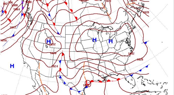
"Fate often spares an undoomed man, if his courage is good." --Beowulf, Book VIII, lines 572-3. Models seem set on a Gulf low with a banana High. The beginning of the storm over TX is in NAM range (stronger and further south with the High).Can we get the mid levels to wobble in just the right way? The WPC gives us all we could ask for at the surface at Day 4 in December, whatever ends up happening: EDIT to add in the end of the KMRX discussion this AM: "At this range some of the details are unclear, but it does look as if the potential for wintry precipitation Friday night and through much of the weekend is possible/probable. Details on ptype timing/transition and precipitation totals will become more clear over the upcoming days as this system is still over the Pacific and not being observed in the RAOB network at this time."
-
I figured since meteorological winter was just around the corner I'd go ahead and get the new observations topic ready. Let the season begin!
- 355 replies
-
- 2
-

-

-
- observations
- measurements
- (and 15 more)
-
First storm tracking of the season. Let’s hope we all get some snow out of this.
-
I just realized that we need an observation thread for Fall. With the remnants of Flo approaching, though it might not be a bad idea to get the Fall obs thread rolling. What is left of Florence looks like it might be a rainmaker(within norms) for the eastern Valley. Wind advisories are hoisted for the mountains. Western NC is under a flood watch. Rivers that flow from NC such as the French Broad and Nolichucky may flood in TN due to rain in North Carolina.
- 110 replies
-
- 2
-
-
-
- fall
- temperatures
- (and 5 more)
-
It is 41 in Kingsport with a windchill of 31. Wind chills are forecast tonight to be in the upper teens to lower 20s. Snow advisories are still posted for mountain communities. Still feels like winter, but spring temps are back in the forecast for this weekend.
-
 Ok, remember the last few posts have been about the past, well today's blog is about the future. IN the next 8-10 days periods of cold and rain are possible with a few mix events, but the main event looks to be in the Saturday/Sunday timeframe for New England storm system. Questions remain, but the gist of the future is that a potential coastal storm is looming. Currently models are not far enough south with the low, so it appears it will be a rain event, but with a Greenland block and PNA ridging, cold air looks strong and should push the upper level low to the southwest over time on the model forecasts. We will have to continue to monitor future runs. For now, potential exists for a snowstorm in New England.