brooklynwx99
-
Posts
6,215 -
Joined
-
Last visited
Content Type
Profiles
Blogs
Forums
American Weather
Media Demo
Store
Gallery
Everything posted by brooklynwx99
-

2025-2026 ENSO
brooklynwx99 replied to 40/70 Benchmark's topic in Weather Forecasting and Discussion
I think part of it is that back in the 2000s and 2010s, most KU setups delivered (March 2018 is a great example), and now we're seeing some flies in the ointment. sure, some of those failure modes are popping up more and more because of CC, but I think we got a bit spoiled, so now a block pops up and everyone expects a KU (I am personally guilty of this and am trying to remove this bias) mid-Feb easily could have occurred, the ULL just became a bit sloppy and the system became more disorganized... it still delivered historic snow to VA beach, and there was also a once in a lifetime Gulf Coast storm -
2025-2026 ENSO
brooklynwx99 replied to 40/70 Benchmark's topic in Weather Forecasting and Discussion
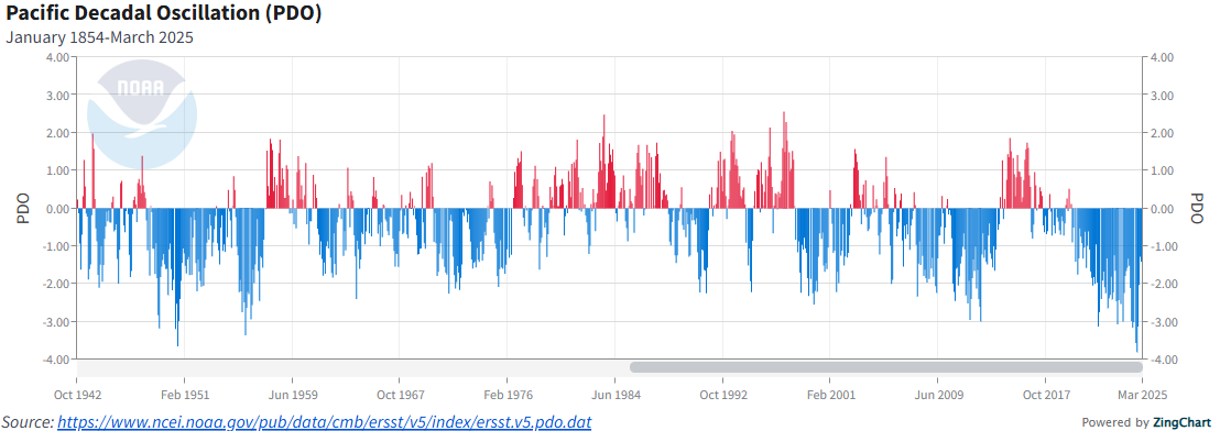
I don't think there's any legitimate way that the 2013-15 +PDO could be viewed as a "three year cycle" or whatever. there have been numerous instances of +PDO in -PDO cycles and vice versa since the 40s. it's nothing new. you can see the same thing in the late 50s, late 80s, and the mid-2000s. IMO it's just authors trying to rationalize typical variance as a broader consequence of climate change
-
the Southeast and southern MA is loving climate change right now
-
the heights over British Columbia are higher again
-
simple, the GFS is tallest with the ridge out west and allows the NS to have better momentum
-
the CMC and UKMET are also much better looking out west. I am definitely taking the GFS with a grain of salt but it's not that far off, and the PNA has been trending better for a while now
-
FWIW the CMC did make some nice shifts synoptically
-
the trend with the PNA over the last model cycle has been pretty nice. went from a trough to a full latitude ridge on the GEFS over BC
-
agreed, though the trend for more -NAO probably does limit the extent of the warmth
-
dude that was two weeks ago, damn
-
it's an operational model at 10 days out. it will do that, as will any other OP at this range
-
all ensembles maintain a signal for the 9-10th, just a matter of phasing. worth keeping an eye on
-
GEFS has quite a signal with lots of strong coastals
-
the transient 50/50 and -EPO do help this threat. the synoptics are there, it just needs to deliver with a phase
-
next shot at something more substantial is probably the 9-10th as the cutter drops the TPV down and a wave tries to amp into the colder airmass with the transient PNA spike. after that, it's likely curtains outside of NNE with some warm weather on the way
-
oh god please no
-
the AIFS humping is going to be unbearable for a while. past 5 days it isn't as good as any other model, really
-
he shits on every storm threat that has ever formed
-
i saw people even comparing this to Jan 2015. that was on a totally different level of fail. not even close
-
yeah, trust me, it was one of the more stunning model collapses in the last several years. absolutely sucked
-
yup, I will reassess in 2030 or so. the sample size is just too small and we could get blasted a few times to close the decade for all anyone knows. people also thought the massive WC ridges from 2013-15 were going to be the new norm. how laughable that seems now
-
i mean, it is, but 48 hours is a bit much. the models capitulated and it totally blew, but it was at 120-144 hours out. that happens. we're in agreement that it would be a different story if we were inside of three days god, i can't wait for an effective El Nino. hopefully next year
-
that's kinda silly. that attitude is borne out of frustration rather than anything scientific
-
yup, some people never understand that good patterns just increase the odds for snow, not guarantee it. we literally just saw that play out this week!
-
anything of substance to add? no? no wonder why mets barely post here anymore. doesn't seem to be an issue in other subforums