brooklynwx99
-
Posts
6,233 -
Joined
-
Last visited
Content Type
Profiles
Blogs
Forums
American Weather
Media Demo
Store
Gallery
Everything posted by brooklynwx99
-
 what a day. i find it rather unsettling that people that appreciate the weather can't seem to understand that we are impacting it there is a debate to be had as to how we are impacting the weather directly, aside from a direct increase in overall temperature, and I think that the debate in that regard is needed and is healthy. for example, debating how the increased warming will impact nor'easter potential is worth the time, and the perspectives on that topic are appreciated however, totally denying the impact that we have had is complete BS. that stems from denial or political affiliation (which is honestly even worse than straight up denial) sorry to mods if this needs to be cleaned up btw
 -
2025-2026 ENSO
brooklynwx99 replied to 40/70 Benchmark's topic in Weather Forecasting and Discussion
i swear, reading this thread is like groundhog day sometimes -
2025-2026 ENSO
brooklynwx99 replied to 40/70 Benchmark's topic in Weather Forecasting and Discussion
it's refreshing to see these blocked patterns begin to show up in the medium range. similar stuff happened last year.thumb.gif.7818506630c317343770598cc9fc88f0.gif)
-
2025-2026 ENSO
brooklynwx99 replied to 40/70 Benchmark's topic in Weather Forecasting and Discussion
wow, the ECMWF is super aggressive with the weakening of the SPV early on. can't remember the last time i've seen a SPV potentially this weak to start a winter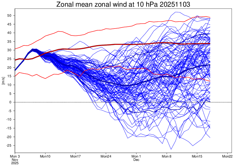
-
2025-2026 ENSO
brooklynwx99 replied to 40/70 Benchmark's topic in Weather Forecasting and Discussion
kind of a wild trend. hopefully we see more of this in the coming months... it's getting far enough into autumn that it holds a bit of weight. we saw the same -NAO trends last winter
-
2025-2026 ENSO
brooklynwx99 replied to 40/70 Benchmark's topic in Weather Forecasting and Discussion
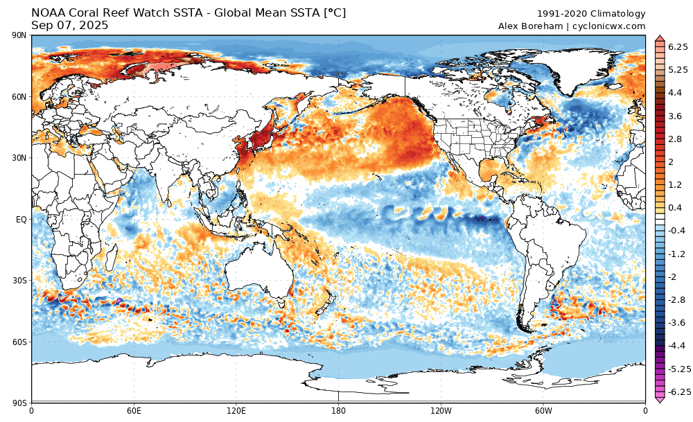
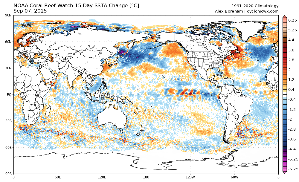
this is a pretty wild change near Japan since August. that heatwave is almost entirely wiped out... wondering if this is a change to a +PDO down the road, especially if we get a Nino next year
-
2025-2026 ENSO
brooklynwx99 replied to 40/70 Benchmark's topic in Weather Forecasting and Discussion
we might as well mention the cooling of the majority of the N PAC basin, especially near Japan and SW of the Aleutian Islands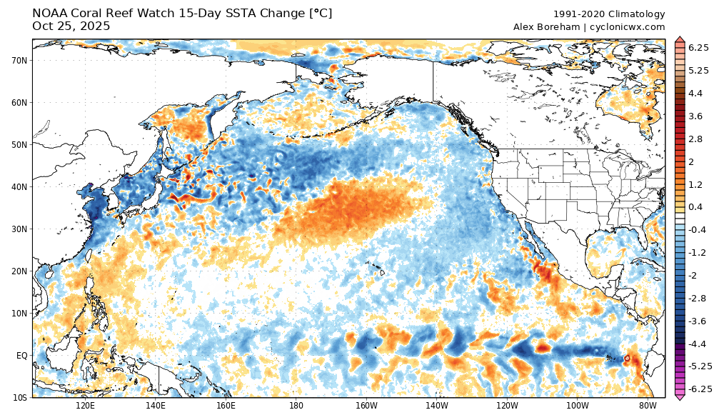
-
2025-2026 ENSO
brooklynwx99 replied to 40/70 Benchmark's topic in Weather Forecasting and Discussion
you seem a bit traumatized, dude. -NAO blocking has been in place for pretty much all of NYC's largest storms. to say that Greenland blocking is not beneficial is untrue -
2025-2026 ENSO
brooklynwx99 replied to 40/70 Benchmark's topic in Weather Forecasting and Discussion
one would think that a Nino developing next year would actually kick things positive for a stretch -
2025-2026 ENSO
brooklynwx99 replied to 40/70 Benchmark's topic in Weather Forecasting and Discussion
I prefer to think of the AO as general blocking, the EPO as an Arctic cold index (independent on where it's going), the PNA as a modulator on where cold ends up in the CONUS, and the NAO as a big storm modifier, at least for NYC south. very difficult to get a MECS+ without a -NAO down here i've done research on preloading patterns and the -NAO really has no impact up by you. it's all forced by the Pacific, as you know (see Jan 2022, Jan 2015) -
2025-2026 ENSO
brooklynwx99 replied to 40/70 Benchmark's topic in Weather Forecasting and Discussion
yeah, this fall is really reminding me of last fall so far. last year continues to be a pretty strong analog -
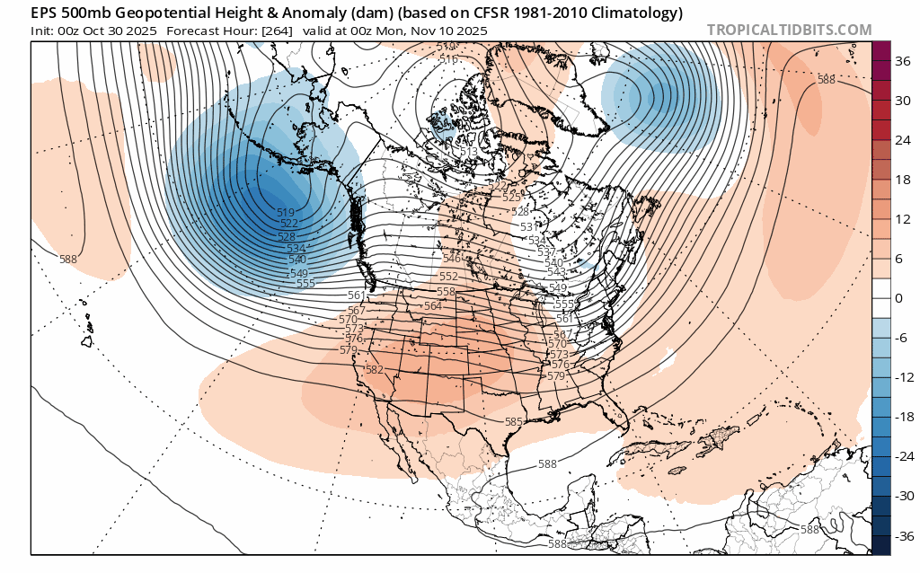
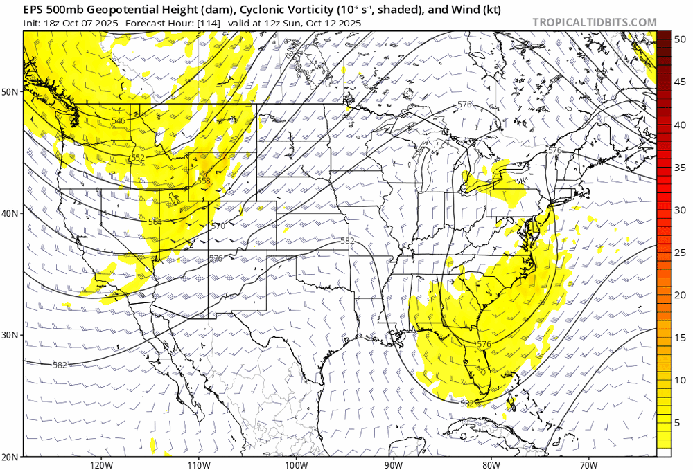
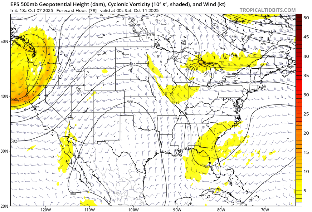
the S/W becoming more amplified over WI leads to increased phasing down the line. the entire tilt of the trough is more negative as a result, leading to a much more tucked and amplified system. this is a solid example of looking at 500mb ensemble trends to see how phasing impacts storm track. with all major ensembles on board inside of D5 (CMC was holding out a bit yesterday and this morning), confidence in this system making significant impacts is a good bit higher

-
2025-2026 ENSO
brooklynwx99 replied to 40/70 Benchmark's topic in Weather Forecasting and Discussion
since I almost exclusively use analogs since 2000 with only a few in the 90s, I think the 91-20 climo is okay to use -
2025-2026 ENSO
brooklynwx99 replied to 40/70 Benchmark's topic in Weather Forecasting and Discussion
yeah, not the best job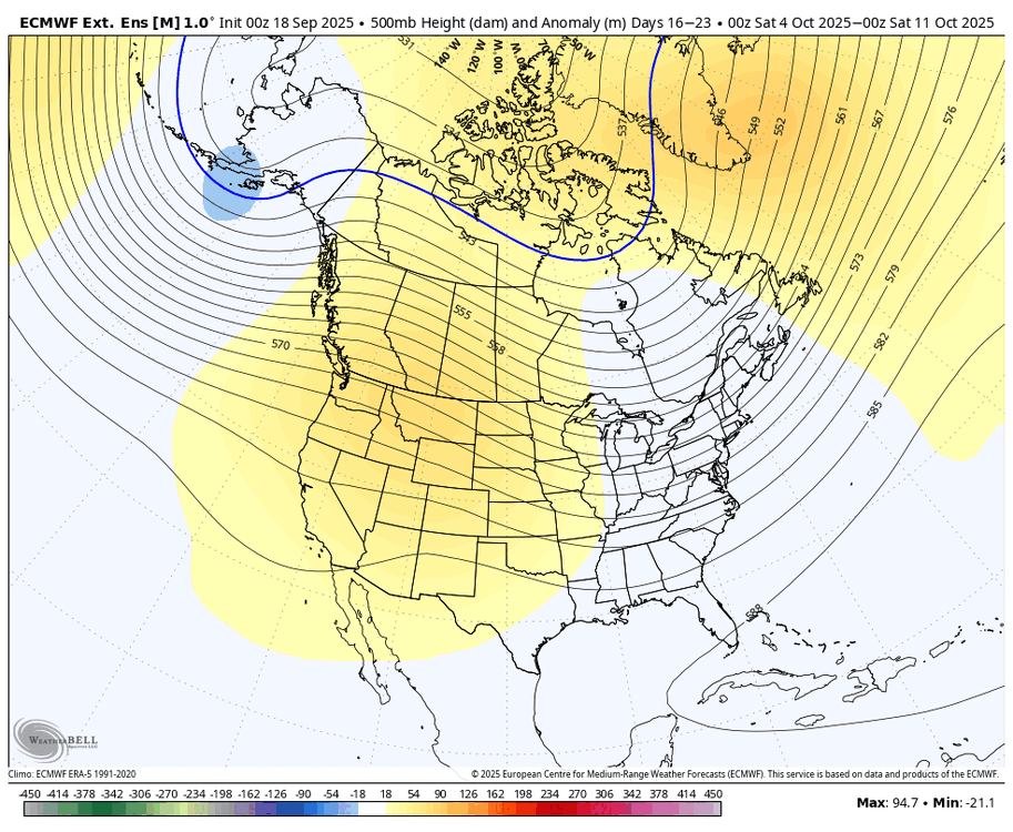
-
2025-2026 ENSO
brooklynwx99 replied to 40/70 Benchmark's topic in Weather Forecasting and Discussion
that's going to flip back over the next couple of weeks with the anomalous ridge developing there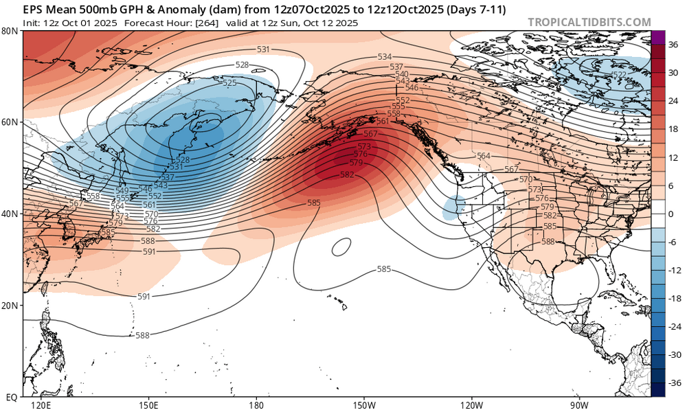
-
2025-2026 ENSO
brooklynwx99 replied to 40/70 Benchmark's topic in Weather Forecasting and Discussion
in recent years? when has it ever not been tough to maintain a -EPO indefinitely? -
2025-2026 ENSO
brooklynwx99 replied to 40/70 Benchmark's topic in Weather Forecasting and Discussion
I can assure you, when we do get a good winter from NYC south, I doubt anyone will have actually forecasted it beforehand. including myself -
i do think that 2013-14 is a solid analog for other reasons, though... ENSO strength and orientation is a dead ringer along with similar QBO and solar
-
yeah, lots of warm water off the WC and in the GoA
-
2025-2026 ENSO
brooklynwx99 replied to 40/70 Benchmark's topic in Weather Forecasting and Discussion
no chatter about NPAC SSTs lately? PDO rose quite a bit in the last couple of weeks. that's also a ton of warm water off the WC
-
2025-2026 ENSO
brooklynwx99 replied to 40/70 Benchmark's topic in Weather Forecasting and Discussion
so you think that we're going to need a major volcanic eruption to see a 50"+ snowfall winter in NYC? I find that hard to believe given how much more moisture is available when cold air is around. seems like a bit of a stretch -
2025-2026 ENSO
brooklynwx99 replied to 40/70 Benchmark's topic in Weather Forecasting and Discussion
is it really? we had four 50"+ winters out of six from 2009-10 to 2014-15. it was ridiculous we also had similarly crappy stretches in the 70s-90s, we just had a lot more 10-15" winters than the single digit ones (not all that much better IMO) -
2025-2026 ENSO
brooklynwx99 replied to 40/70 Benchmark's topic in Weather Forecasting and Discussion
i earnestly believe that some of what's been occurring for the last few years is regression to the mean that 20 year stretch was insane... NYC averaged 34" of snow from 2002-03 to 2020-21. that was not going to last -
2025-2026 ENSO
brooklynwx99 replied to 40/70 Benchmark's topic in Weather Forecasting and Discussion
although I didn't like the results, I would run the 500mb pattern back in a heartbeat. that winter was a clinic on how to get the least amount of snow with favorable 500mb patterns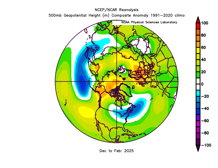
-
2025-2026 ENSO
brooklynwx99 replied to 40/70 Benchmark's topic in Weather Forecasting and Discussion
looking at RONI, the MJJ this year is -0.4 and last year it was -0.45. i also don't take the N ATL SSTs into account all that much, I find correlations with our weather pretty weak. even though the heatwave near Japan is stronger, the SSTs off the WC are also higher, so the PDO is about the same. if anything, it was more consistently under -3 last year overall, I think there are a lot of big picture similarities. I don't like to get too granular with LR forecasting


.gif.a47b047a4fe964911d59a77e5b0bb118.gif)