brooklynwx99
-
Posts
6,233 -
Joined
-
Last visited
Content Type
Profiles
Blogs
Forums
American Weather
Media Demo
Store
Gallery
Everything posted by brooklynwx99
-
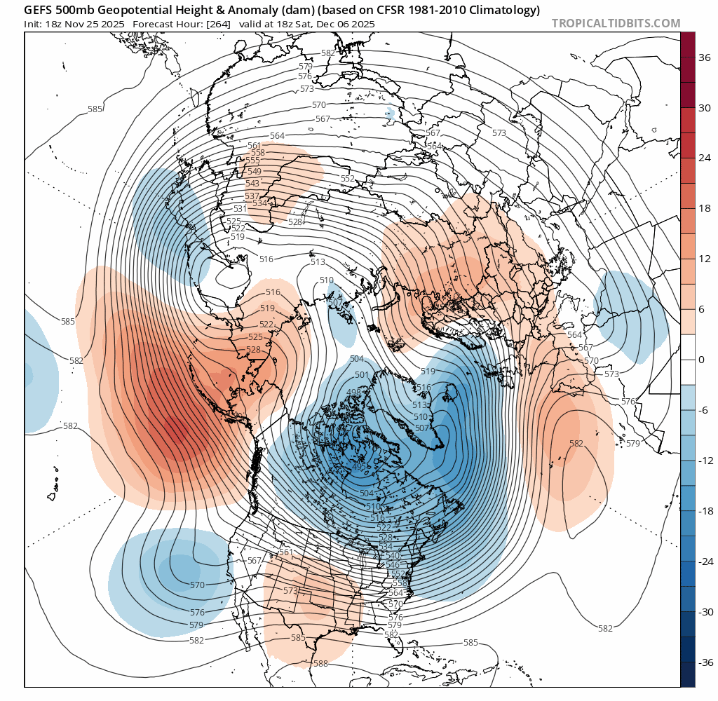
12-13th might be an actual window to watch. nice to see the ridge out west trend taller, which helps shift the trough west as well

-
nice to see the ridge out west trend taller. helps the trough location and amplitude

-

December 2025 regional war/obs/disco thread
brooklynwx99 replied to Torch Tiger's topic in New England
yeah, can see heights trending higher in the West and the trough inching into a better spot as a result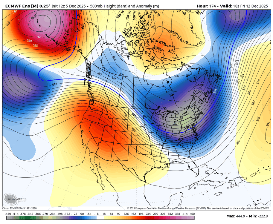
-
2025-2026 ENSO
brooklynwx99 replied to 40/70 Benchmark's topic in Weather Forecasting and Discussion
the weeklies usually defer to ENSO climo as you head later into the winter anyway -
2025-2026 ENSO
brooklynwx99 replied to 40/70 Benchmark's topic in Weather Forecasting and Discussion
personally, I usually go about saying what the pattern may call for (small to mod events) rather than saying that it can't satisfy the upper echelon of events. like how cold is it? will it be dry? what's the mean storm track like? what he said wasn't incorrect... I agree with him. I just think there's more value added saying what you can get or the flavor of the pattern itself rather stating that you won't see a NESIS level event. you will be able to do that 90% of the time -
2025-2026 ENSO
brooklynwx99 replied to 40/70 Benchmark's topic in Weather Forecasting and Discussion
i do think a larger storm is possible after the 15th into early Jan if the -NAO holds on and heights rise out west a bit more with help from tropical forcing, but that's way out there -
2025-2026 ENSO
brooklynwx99 replied to 40/70 Benchmark's topic in Weather Forecasting and Discussion
who was calling for one? I don't think anybody has mentioned the risk for one... seems like light to mod events generally my point was that saying that a pattern isn't conducive for historic storms isn't really saying all that much. you can say that about most patterns. it's like saying most football players won't make it to the NFL. it's implied -
2025-2026 ENSO
brooklynwx99 replied to 40/70 Benchmark's topic in Weather Forecasting and Discussion
to be fair, most patterns are "hostile to KUs." they're rare and require some specific features -
2025-2026 ENSO
brooklynwx99 replied to 40/70 Benchmark's topic in Weather Forecasting and Discussion
i mean, I don't think it's deniable that the pattern looks conducive for at BN temps for most of the month. looks a lot better than it did last week with the GEFS falling flat on its face. then, we should see that pattern continue into mid-late month aside from maybe a brief warmup around the 13th or so snow is more difficult to predict, though. the northern mid-Atlantic should see chances through the month, especially after the 15th IMO you know Tony just regurgitates that stuff though lmao -
2025-2026 ENSO
brooklynwx99 replied to 40/70 Benchmark's topic in Weather Forecasting and Discussion
who are you even following? nobody reputable is calling for that -
2025-2026 ENSO
brooklynwx99 replied to 40/70 Benchmark's topic in Weather Forecasting and Discussion
lol, GEFS capitulating. much lower AO, -NAO signal strengthening too
-
2025-2026 ENSO
brooklynwx99 replied to 40/70 Benchmark's topic in Weather Forecasting and Discussion
if a transient AK vortex does develop, it would be due to a strongly negative WPO… you’d be getting modified Siberian air, not a true Pacific onslaught sure, you’d modify eventually, but it wouldn’t be all that bad
-
2025-2026 ENSO
brooklynwx99 replied to 40/70 Benchmark's topic in Weather Forecasting and Discussion
quite the trend with the AO… almost getting a -WPO/-NAO ridge bridge at this point. makes sense with the weak SPV
-
First Winter Storm to kickoff 2025-26 Winter season
brooklynwx99 replied to Baroclinic Zone's topic in New England
i fucking hate the AIFS dude. it gets humped to no end and people rely on it too much sometimes analysis is just “well, the AIFS shows this, so…” and it’s the worst -
First Winter Storm to kickoff 2025-26 Winter season
brooklynwx99 replied to Baroclinic Zone's topic in New England
no problem, Ray! always glad to be of assistance -
First Winter Storm to kickoff 2025-26 Winter season
brooklynwx99 replied to Baroclinic Zone's topic in New England
you know i’m not IMBY-ing, but i do think that the overall pattern favors less consolidation and an outcome more similar to the foreign guidance. it’s progressive -
First Winter Storm to kickoff 2025-26 Winter season
brooklynwx99 replied to Baroclinic Zone's topic in New England
it’s just way more consolidated with the vort as it moves through the Plains and Midwest -
First Winter Storm to kickoff 2025-26 Winter season
brooklynwx99 replied to Baroclinic Zone's topic in New England
GFS on an island… usually ends only one way -
2025-2026 ENSO
brooklynwx99 replied to 40/70 Benchmark's topic in Weather Forecasting and Discussion
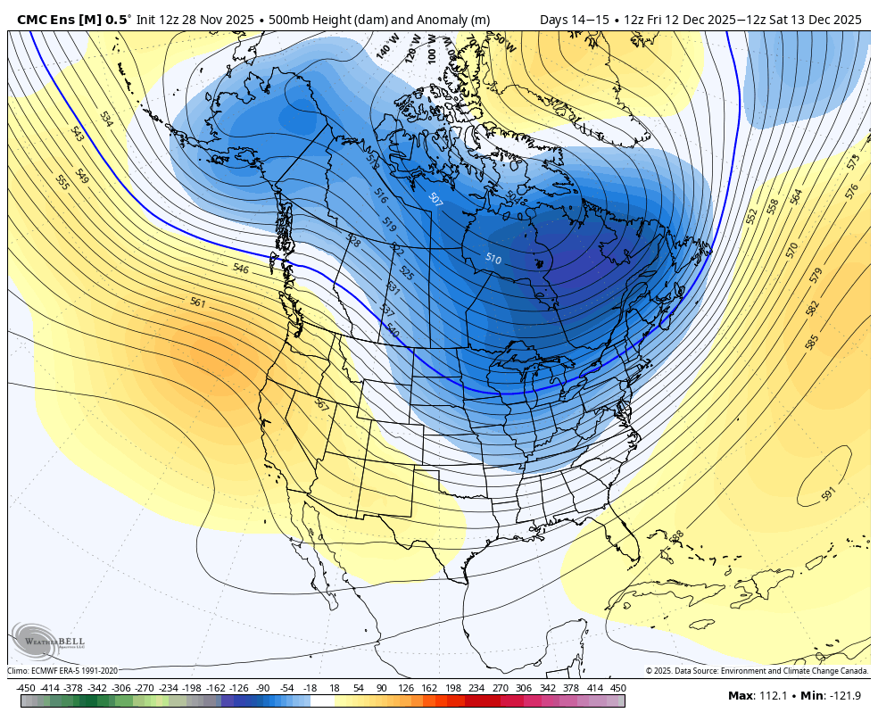
even with said AK vortex (which seems suspect), it’s still cold with a -NAO popping up. this would still be serviceable for a while, and this seems like the worst case scenario through the 10th. EPS and GEPS are much colder with +PNA
-
December 2025 regional war/obs/disco thread
brooklynwx99 replied to Torch Tiger's topic in New England
i like to use the GEPS as a bit of a tiebreaker in these instances… def more EPS-like like seeing that -NAO over the top, really helps out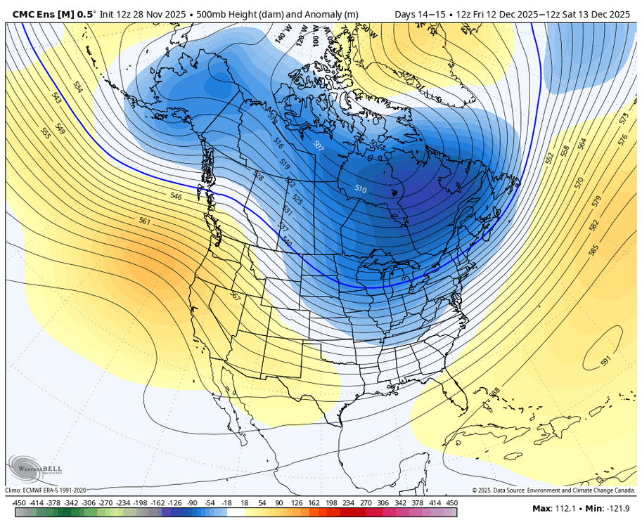
-
December 2025 regional war/obs/disco thread
brooklynwx99 replied to Torch Tiger's topic in New England
i’m fine with leaning a certain way based on certain reasoning. you’ll be wrong at that range sometimes, it is what it is the storm also hasn’t verified, though -
2025-2026 ENSO
brooklynwx99 replied to 40/70 Benchmark's topic in Weather Forecasting and Discussion
this just looks like twitter engagement bait. every MJO forecast has another wave propagating into 8… those plots just don’t go out far enough -
December 2025 regional war/obs/disco thread
brooklynwx99 replied to Torch Tiger's topic in New England

-
December 2025 regional war/obs/disco thread
brooklynwx99 replied to Torch Tiger's topic in New England
personally, given the pattern, i would find something suppressed and washed out more likely than something as amped as the GFS -
December 2025 regional war/obs/disco thread
brooklynwx99 replied to Torch Tiger's topic in New England
way more likely that the mid-week system is a POS than something amped and rainy IMO