MillvilleWx
-
Posts
5,544 -
Joined
-
Last visited
Content Type
Profiles
Blogs
Forums
American Weather
Media Demo
Store
Gallery
Everything posted by MillvilleWx
-
We are at that time of year where the difference in temp between work and my house near the South River can be as much as 10-15F difference. Driving home yesterday, I hit 54F on Rt50 and once I pulled into the driveway at the house, it was 44F. South river was still partially frozen in spots but should be gone in the next few days. Water temp still probably 33-36F though, so the cooler temps in the immediate neighborhoods will probably remain chillier than inland.
-
Yeah, that was a big take away for me this morning when interrogating like I normally do once I get settled in. The afternoon package yesterday started giving me hints of this being a sloppier phase, or phasing a bit too late leading to a more eastern solution, or weaker and south. I think the major bomb solutions are relatively off the table, but there is still some time for adjustment. So long as the vort ejection gets sheared to the west before any phasing, we will not be looking at any massive outputs, but we can still score something in this setup. It's not completely dead yet........
-

-
Looks like some inversion tendencies coupled with snow melt and evaporation leading to higher concentrations of fine particulate matter during the mornings and early afternoons. Moderate levels expected, so nothing too crazy, but some localized maxima are certainly plausible in the AM. https://mde.maryland.gov/programs/air/airqualitymonitoring/pages/aqforecast.aspx
-
On the winter desk 6 of the next 7 days. Hopefully I can bring us home
-
2014 was such a wild winter. That run of snow and cold was incredible. We had snow on the ground for over 40 days at Millersville when I was in college. Surreal
-
Yes they do. I want to check the cluster analysis once the ensembles are out. I'm curious to see if there was a notable jump in members with a more amplified setup. This morning it was the 3rd of 4th most in the camp, however I have seen things flip before, so it'll be something to look at. That was a really stark shift in run-to-run variance, so I'm wondering if there is some merit to that. It's still at the D3-4 turn in terms of time, plenty of time for a notable adjustment.
-
You would chase you say? I might know a guy
-
I noticed on my walk yesterday evening how pristine the undisturbed areas look even after all these weeks. It still gives off a sheen when the light reflects off it. It's so smooth and the minor undulations can be noticed when you look at it more intently. That storm will be remembered forever in these parts. As for the weather this morning, balmy in the mid-40s when I left the house. Felt really nice actually.
-
As a meteorologist who does this shit professionally, we are all weirdos. No other set of people in their right mind will divulge into breakdowns of a computer simulation for an entity that is far more complex in the grand scheme than any of us can comprehend at lead times greater than 24 hrs, gnashing and gnawing of teeth when the algorithm's in place don't spit out a shade of blue. Weather enthusiasts are some of the more complex individuals in that we take immense amounts of gratification in cheering and lamenting on a physical construct we have absolutely no control over. If you have ever looked at a model run beyond 72 hrs to see what COULD happen in the world of weather and ran to comment on a message board....congratulations, you are a weirdo. I for one accept my weirdness and show it as a badge because weather is something all individuals have to contend with and it's fascinating to know how something so complex can yield such incredible results. Fin
-
 I’m actually at the point I want a thaw to just get rid of the snowcrete. Then it can try for one last hurrah for the season. Either way, this winter is one to remember with the snowcrete storm followed by a crazy sustained cold period.
 -
Got woken up at 230am with a brutal migraine and ended up calling out of work (Thankfully non-operational shift). Is anyone else having headaches recently? I think the dryness is starting to crush my sinuses and hits at night. Might have to start back up a saline rinse regimine
-
I always a appreciate a strong defensive performance. This is beautiful. Mike MacDonald is a mastermind. So happy for him and the Seahawks right now.
-
I am loving this ass kicking the Pats are receiving. Not a Bad Bunny listener, but I enjoyed the vibe and energy from the music. My Mom is from Ecuador, so I understand some of the lyrics. It was a good time.
-
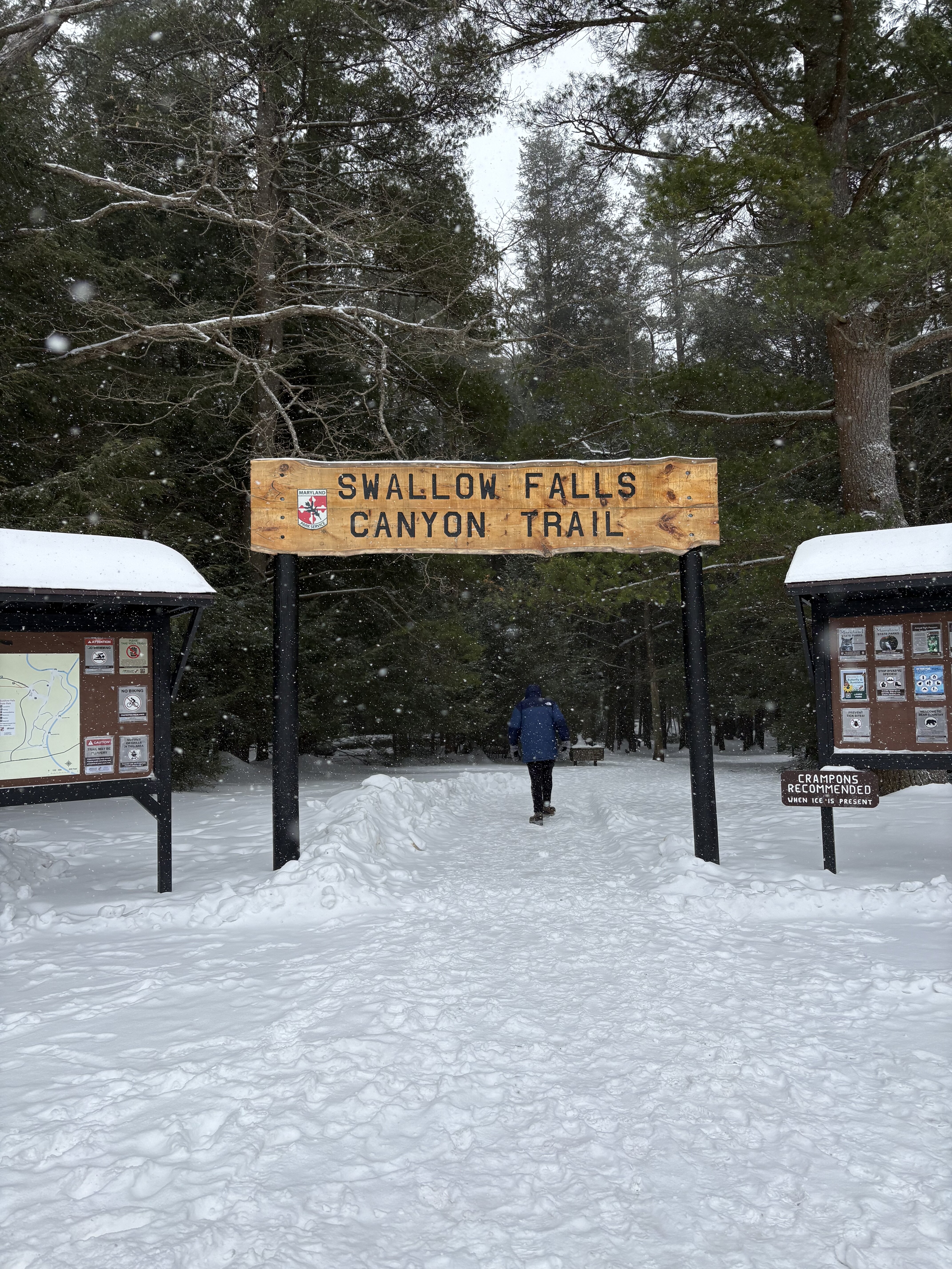
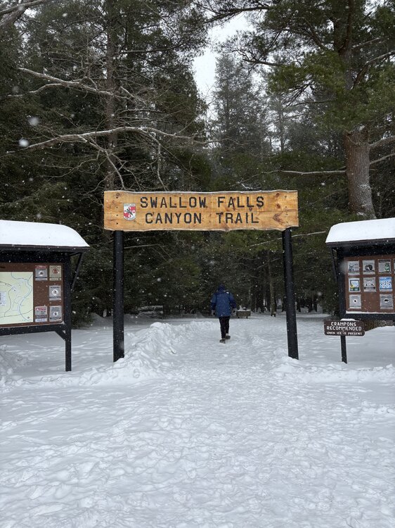
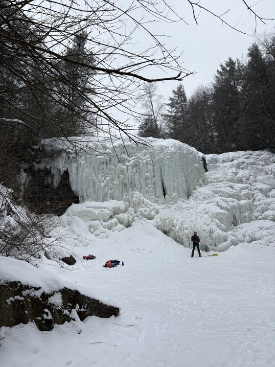
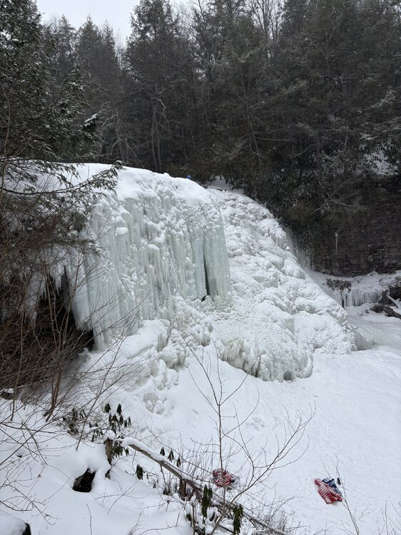
Some shots I took with @katabaticwhen we visited Swallow Falls on Friday 2/6
- 46 replies
-
- 11
-

-

-
I want to take a moment and thank @katabatic for amazing hospitality and a truly fun trip out to Western MD and the Canaan Valley region, including a slide over into Davis, WV. That was such a fun day of friendship and loving every moment of winter. It was a truly deep winter day with temps in the upper teens to low 20’s with snow falling the entire day. Saw all of the intensities too from light flurries to heavy snow. The Arctic front capture is a moment I’ll never forget. That was absolutely wild. It’s been a long time since I’ve seen something like that. Likely since 2/14/15 up at college. Would do it again in a heart beat!! Thanks again @katabatic!! Now I have excuse to come up there since we never got a chance to eat at Englanders
-
Some insane wind gusts out of nowhere in the lowlands. Mixing must be finishing out right before sunset. That was out of nowhere after a lull
-
We love verification!! What an experience.
-
One of the strongest gusts we had. We had one that was stronger but I didn’t have a camera ready. Easy 50+ in video. The one I missed was 60+. I had to stand still and keep my balance. 86AEF405-E88D-44A0-9A56-1715E7C91F9F.mov
-
Right as the squall was hitting. Pardon language end of video. Just surreal IMG_0009.mov
- 553 replies
-
- 11
-
-

-

-

-
On top of Keyers Ridge. Wind gusts 40-60mph with snowfall rates easily at 2”/hr. The gas station 150 yards from us completely disappeared when it came through. Absolutely stunning display of Mother Nature. EB5754F4-B744-483F-951F-C958A305BD6C.mp4
- 553 replies
-
- 19
-
-
-
That was one of the most insane, ferocious weather experiences of my life. Just wow. Videos will be shared.
-
Legit SN+ on top of Keysers Ridge before the squall. Reports upstream were 2-3” in 45 min. This is gonna be wild.
-
Sure was!! Man, what a pull!