MillvilleWx
-
Posts
5,543 -
Joined
-
Last visited
Content Type
Profiles
Blogs
Forums
American Weather
Media Demo
Store
Gallery
Everything posted by MillvilleWx
-
HRRR is best when it's inside 8 hrs, but can more useful up to 12 hrs if it is assimilating the data correctly. It has its struggles with certain setups and is best within convective environments or well-established thermal environments. Winter is not its strong suit, but can be useful at times. Right now, regional CAMs are better at handling this type of setup. Best ascent has been modeled south through the day, but some very light precip is still plausible north of I-66, but not looking likely at this point.
-
I'm probably going to slide out to western Garrett Co. for this one. I am off after Thursday AM, so I'm probably going to leave early Friday AM and head out there for the Arctic front and snow squalls. Should be fun! Anyone care to join the ride?
-
Analysis of pavement temps after today show there has been very little movement up in the temperatures with most places between 22-27F off the asphalt. Anything that does fall will easily stick to every single surface, so anything could be impactful for rush hour on Wednesday morning. Unless we get nothing of course.....but I'm not manifesting that
-
Got to 37F briefly in the neighborhood today, but was down to 33F when I left the house and falling. Expecting some black ice issues to crop up with some of this melting and subsequent refreezing. Stuff will take a small hit next few days, even with any refresher snow we receive before it settles back to pure concrete this weekend.
-
You’re not even using it to its full capabilities! At least put up the Kuchera and give yourself an extra 0.1”
-
Just some context for how insane this cold outbreak is in Florida, here are some nuggets for your viewing pleasure.... Great Falls, MT was officially warmer than Key West, FL today by 4 whole degrees (62F vs 58F) Boca Raton, FL never got out of the 40s for a high (48F) Havana, Cuba just BARELY beat out Great Falls for a high today (63F vs 62F) 12z sounding from KEY eclipsed their low 850mb temp record for the day by reporting below 0C after never recording below 5C on this date at any point in their history of record dating back to 1954 The 850mb temperature at KEY was -1.8C at 12z. If this is confirmed, it will be the all time coldest 850mb temperature ever recorded via RAOB at Key West, again dating back to obs from 1954. Over 40000 soundings have been launched in its period of record
-
Currently 26° after a low of 14°. Didn’t feel too bad this morning coming home. Still chilly
-
This is easily one of the craziest cold stretches in my lifetime. Insane enough, one of my coldest was the 2021 Arctic Outbreak when I lived in TX. Midland was below freezing for 8 days in a row with 3 days highs in the teens and one morning below zero. I seem to bring winter with me wherever I go….I’ll take it!! I love winter
-
Did a live interview with BBC this evening. Love my job and completing interviews!
-

The “I bring the mojo” Jan 30-Feb 1 potential winter storm
MillvilleWx replied to lilj4425's topic in Southeastern States
Right now the snowfall is light to moderate in your area, but watching the banding the east near and north of Goldsboro. If that can make it to the RDU area, you could push 7-8", no question. That stuff is heavy over in that direction. Likely 1-2"/hr stuff. 5" in 4hrs is incredibly impressive. So glad you guys in the RDU area got in on the action after a ridiculous hole in the precip field. -
January 30th- Feb 1st ULL and coastal storm obs
MillvilleWx replied to JoshM's topic in Southeastern States
Reports from New Bern are over 10" with some reports closing in on a foot according to MHX. Been chatting with them working at WPC. This is going to rival 1989 and 1965 in your parts. Incredible storm! -
And as @Terpeastmentioned, that was late March too. Roll that into February and you would be looking at a wall of white. That is a pretty Northern Hemi setup right there for these parts. Still need some luck in the storm department, but the look is pretty solid for potential.
-
Sean Payton and Ben Johnson disciple....can't say I hate being under those names. Apparently Ben Johnson said he reminds him of him a lot with his thought process and play-calling. I like hearing that. He's a young mind that hopefully can utilize Lamar and the offensive weapons to their full advantage. We need to have imagination with the play-calling, and hopefully he can kick Faalele to the curb. That's one change that needs to happen immediately.
-
Forecasted that min too on the QPF and showed up in the snowfall forecast. Feel bad for those in RAH that wanted snow. I would be so mad, no joke, but weather going to weather, whether we like it or not
-
Thank God. No offense to us up here, but I forecasted that last night. We love verification. Now, let’s try to get a little refresher this coming week and then track big dog potential after the 9th.
-
Low of 10 literally every morning the last 3, however the high has not been able to break 23° any of those days either. Crazy run of winter here in the lowlands. The ice/snow piles have not budged once here next to the South River, which btw is completely frozen over.
-
AIFS has done particularly well with verification on the lower end of QPF distribution (<= 0.25") and has a good indication of the coverage within those bounds. It still struggles with higher QPF allotments, especially anything with convective backgrounds. Might get the areal extent of the "where" right, but magnitude is going to struggle. This has been the case for the past few years of evaluations. Totally agree with the SLP and 5H outputs being the areas it does the best with. I have noticed it tends to waver outside the D5 window, which is the case with next weeks system as well, but it will slowly move and hold firm between the D3-5 window before usually settling within the bounds of a solution. Atmospheric complexities are still prevalent within the grand scheme and the AI models will still be subject to variability at leads due to the complex variables at hand. They are a useful tool and one that helps aid in medium and short range forecasting.
-
Surprisingly, it was pretty damn cold in that run in 2010. 1/29/10 through 2/17/10 was very much below normal with both monster snowstorms in there, and the pre-cursor storm end of January. DCA has a better than -10 departure average for the temps in that time beyond the first storm end of January. For extreme cold, you do have to go back to the 90s for that run. 1994 still takes the cake around here.
-
Double barrel lows are actually common in these setups and that's something the GFS has been trying to show in its evolution. This setup is very complex and will include these types of variables whenever it materializes.
-
Omg. Well, I’m glad you are okay but that is scary as all get out. I’ve had a tire piece off a semi jump a retaining wall in TX and smack my windshield and leave a massive rubber mark on the driver side. I’m happy it didn’t smash my windshield though, but that sudden impact is scary as anything.
-
I’m very happy you showed the Hazards Forecast for the CONUS as it’s a pretty good product for stakeholders to utilize in order to look out for potential weather hazards in the medium range for decision making purposes. However, just to correct, and only doing this because it’s my office that does it, this is a WPC product, not SPC. SPC is a different office that specializes in severe and fire weather with mesoscale discussions for winter weather created as well. Just an FYI, we are different
-
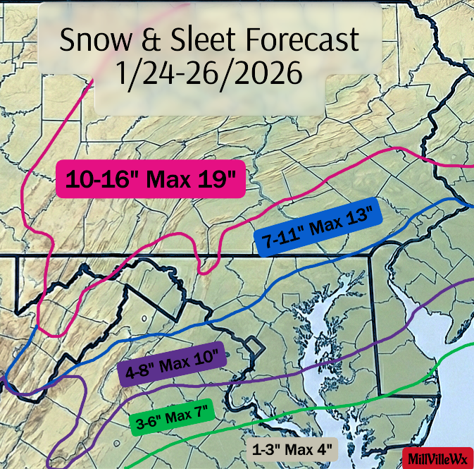
Looking at my forecast and verification via LSR’s, I think I did a decent job in capturing the event. I wish I stuck with my higher totals I had for the region because those verified. QPF was pretty incredible and helped a ton, even with all the sleet. Overall, not bad. I give myself an A- or B+. I’ll take it. Any feedback is welcome
-
I start night shifts late this week, so I could very well be in the thick of forecasting this if it comes to fruition. Here’s to another week of tracking
-
I can tell you we got over 9” for our areas. We went with 9.4” official. It was just hours on end of moderate precip throughout the event. Never got heavy, but never got truly light either. Just steady as could be in reflectivity.