MillvilleWx
-
Posts
5,542 -
Joined
-
Last visited
Content Type
Profiles
Blogs
Forums
American Weather
Media Demo
Store
Gallery
Everything posted by MillvilleWx
-

January 24-26: Miracle or Mirage JV/Banter Thread!
MillvilleWx replied to SnowenOutThere's topic in Mid Atlantic
@MountainGeek @clskinsfan @Wxtrix @DDweatherman Appreciate all the responses from my little inquiry on hosting me out towards your area, or helping with designating where to stay if I were to chase out that direction. Looks like some friends of mine out by Martinsburg said they would love to host me, so I think that’s the route that I’ll end up going. I’ll confer later today, but again, I appreciate the responses and warm welcome (Clskinfan) to your home. Should be a fun storm with a heck of a front end thump, at the very least for your areas. Enjoy!! -
Oh man, are they in for a treat! You are in an excellent spot too for this one. Any good places to stay around your parts by chance? I am really looking into a chase out in that direction.
-
EC continues to support initial snow thoughts on where the heaviest will occur. I may have to adjust my 10” line further southeast, but there’s time! I need to make it out to the WV Panhandle for this thing. It looks immaculate out there for this one. Anyone want to take in a meteorologist? I’ll bring some booze @clskinsfan ?
-
The N/S will be sampled better by tomorrow as it exits the Arctic regions and comes into more favorable RAOB domain. That said, models are probably still on the right track right now, but a small shift is still plausible once that is alignment with better land data captures. As for the oceanic recons, reading into some responses from the flight members and they said it’s not a magic pill right now for immediate change, but more data collection over the coming 24 hrs will add more to the general picture in the future ingests, so it’s a steady assistance prior to the S/W making “landfall” over Baja.
-
UKMet continuing to show my idea of where the heaviest snow will lie. That corridor along the M/D is gonna get shelled. The WV Panhandle and Northern Neck of VA west of the Potomac is also looking excellent. This is going to be a fun storm when it materializes. Also, I put in an inquiry in the Banter thread if anyone is interested
-
January 24-26: Miracle or Mirage JV/Banter Thread!
MillvilleWx replied to SnowenOutThere's topic in Mid Atlantic
Okay, I have a serious inquiry. I am looking to do a chase and post up somewhere where the snow will be the heaviest and maintain itself through the storm cycle. If anyone is interested, please shoot me a PM and we can chat. I am looking for hotels and where is the best spot to do this. We can talk more in PM. If there is a small group of us, we can discuss via text message. I am off till next Thursday evening, so I am wide open to plan and everything. I want to go where we are gonna get a beat down. If someone has a 4x4, that would be spectacular! -
The certainly will add more definition to the banding aspects of the storm, but even those can shift around up to the immediate term. HRRR can be useful inside 8 hrs and check how it is handling the situation. I’m waiting to see the thermals on the NAM Nest for this one. That is the model that should help pin point advancement of the warm layers and everything. CAMs will be helpful, but we are a ways from that. For now, putting a lot of stock in EC, ECENS, AIFS, NBM, and some GFS/CMC mixed in.
-
I keep telling you guys….that front end thump is gonna mean BUSINESS
-
That is indeed my old stomping grounds. I think the valley will do well in this one. This is a good setup for you guys out by Rt15!
-
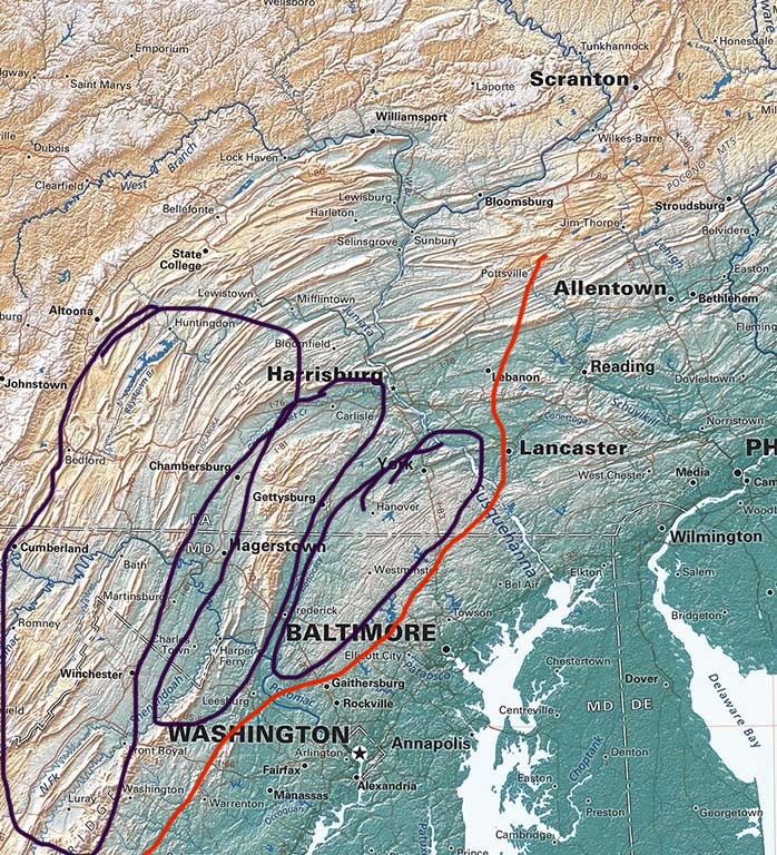
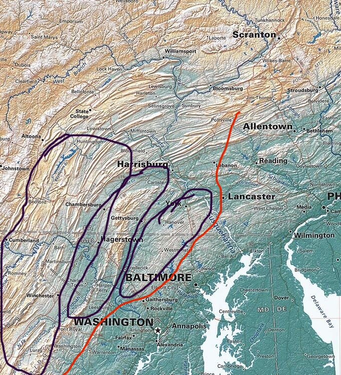
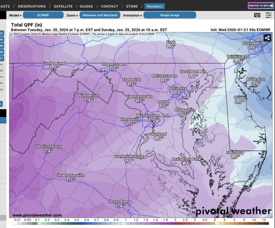
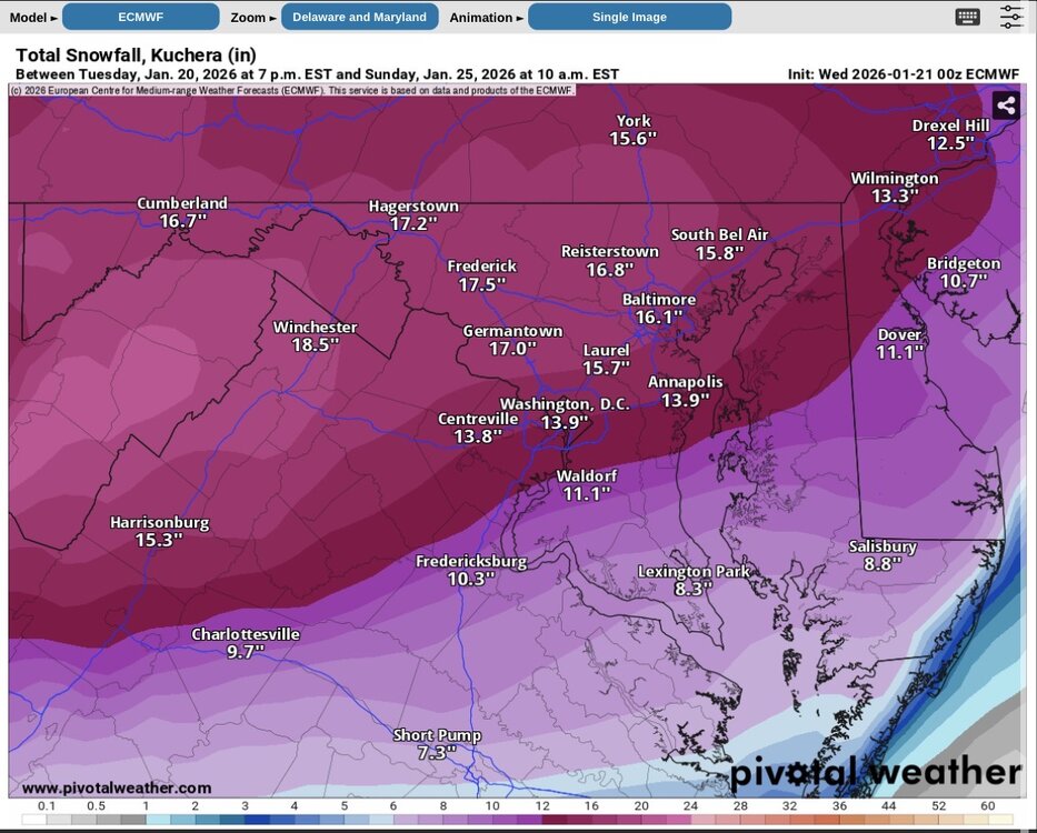
Fall line climo will likely come into play with this one. One things for sure, it’s a QPF bomb. I’m really serious when I say areas that stay all snow will likely see 15-20” and could even get close to 2’. Best spots right now I would put across the M/D with the eastern most area near @mappy and as far north as Harrisburg. Southern edge for that potential is probably the Parrs Ridge zone down Rt27 towards Damascus/Mt Airy and points northwest. Map below is prelim thoughts and NOT my official forecast. Just an outline of thoughts right now. If you are northwest of the red line, I believe you’ll see 10+”, if you are inside the purple, I believe 12-18” is a good forecast right now. Elevations above 800’ have best chance to see 15-20”. Local maxima of 23” is the initial thought. Note, this is manly for this subforum and some of PA. I didn’t try too hard for areas outside the sub, but I will for full forecast.
-
Somewhere between I-70 and the M/D will be the sleet line. And it won’t be prolonged for any particular area near it. I think if you’re south of I-70, I would expect some sleet, but not before a pretty damn good WAA thump. Places that stay all snow will have a shot at 15-20” with this one.
-
For clarity sake Data ingest is ONGOING and will be available for the 00z runs TONIGHT (00z 1/22) There has been NO RECON DATA FOR TODAY (1/21). Thanks
-
I will personally answer any questions and quoted messages to me from the other section when I get the chance. Busy right now. Will answer a little later, so apologies. Thanks for starting a new section @mappy!!
-
I’m genuinely concerned now for your area. This could be really ugly. I know you know the at anytime temp is <28° during ZR, accretion processes are maximized. <25° is usually when you see the greatest ice storms occur and it could very well be that way over your area back into VA.
-
It’s not hyperbole when I say this will be one of the extreme cold plunges we have seen since 2014 in these parts. With snow and ice on the ground will make travel issues for days on end. I’m bullish and think some places will see 18-22” of snow somewhere out of this, it’s just a matter of where. I expect it to occur in Northern MD by your hood across the M/D. Someone is going to get shelled.
-
I like Louis as a person and as a winter mind, but I think he needs to lay off the hard liquor. There isn’t a single model that is that route and there won’t be. Not sure why he said that. Need a full phase over the Four Corners for that.
-
Looking at everything, I think some here are really hung up on the sleet mixing and not enough on the absolute drubbing that WAA pattern is going to bring for the thump up front. This is a setup that can rival the Feb 2014 thump in places. The initial 4hrs when snow becomes heavy too will be big beautiful dendrites in the stronger bands. 1-2”/hr rates likely with some bands >2”/hr considering the strength and depth of the FGEN and DGZ, respectively. If you can remember 2014, there was 2’ of snow in Mt. Airy and not a single model showed that until it basically on top of us. Use climo, know your area for who usually hangs on to snow the longest. This will be a crazy beatdown prior to any flip. Lowlands will mix, metros will mix, eastern shore will mix, and mix will likely make it to I-70….it is what it is. It’s the nature of an upper pattern closing off west of where we want it. However, the snow will come in hot and heavy and last for a while to bring in some great totals, the biggest of which some have seen in a decade. Thermals will be situated as we get into Friday and the NAM Nest comes into line. That’s the model I want to see. That piece of guidance usually sucks, but it does do well at showing the thermal progression while sucking otherwise. It’s gonna snow y’all!! As for Southwest VA, it sucks this shift happened so abruptly. I wasn’t anticipating THIS much of a shift, but there will be some heavy heavy snow upfront before driving sleet. It will be a high impact scenario for so many. And the cold afterwards is NO JOKE!! This isn’t going anywhere.
-
It’s wild out there. A completely different world. I want the front end thump to be like what the models show tonight. That will produce some insane dendrites and walls of white for a while.
-
You know who is going to absolutely clean up on this setup? @jonjon I’ve been noticing the wind pattern with this one out there. Davis might hit 30” with this one.
-
I would wait for sure, but it could be pretty difficult on Monday morning. Still some time to keep an eye on things.
-
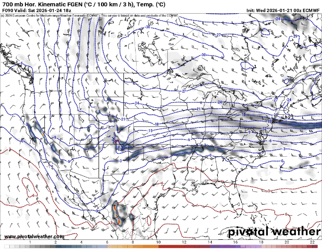
That front end thump is a straight ass kicking before any flip. 1-1.4” of precip, all snow before any flip to IP on the EC for any area west of the Bay. The 700mb FGEN are textbook on Pivotal as the WAA pattern moves in. A solid 10-18” falls before sleet comes into the picture, and the storm actually ends as snow to cap off any sleet. This is a really strong WAA pattern being depicted now with the phasing depiction. It will come in really hot and heavy like a wall. Still time for changes. This system can only climb so far north with the current upper level pattern as progged. QPF prior to flip Snow before any flip 700mb FGEN
-
This makes more sense in a physics sense and the post by Tripol has a lot of merit. This is not a pattern where a low can drive hard to western PA and should in theory struggle to get to WV. This should be more of a primary to transfer from eastern TN/KY to off the Carolina coast. That’s what the AIFS is showing and makes more sense synoptically.
-
Central PA Winter 25/26 Discussion and Obs
MillvilleWx replied to MAG5035's topic in Upstate New York/Pennsylvania
Man, it could be a beautiful sight around here if the CMC/UKMet come to fruition. I am actually on vacation and willing to travel if need be to get into the jackpot. Anyone care to host a meteorologist? I can cook really well, clean up after myself, and I’m a big fan of geeking out over snowstorms -
This was the key. Idc what kind of cold air intrusion you have, a low onto Charleston, WV is gonna cause mix issues. If we get the primary closer to Knoxville area, that probably perfect. I would even work with Eastern KY. Just can’t get it north of there or there will be mixing.
-
It does, but it lowers the accum amounts per panel to account for the lower overall ratio of the sleet. It was 11” of snow before the flip for DC. Was looking earlier.