MillvilleWx
-
Posts
5,544 -
Joined
-
Last visited
Content Type
Profiles
Blogs
Forums
American Weather
Media Demo
Store
Gallery
Everything posted by MillvilleWx
-
This was the key. Idc what kind of cold air intrusion you have, a low onto Charleston, WV is gonna cause mix issues. If we get the primary closer to Knoxville area, that probably perfect. I would even work with Eastern KY. Just can’t get it north of there or there will be mixing.
-
It does, but it lowers the accum amounts per panel to account for the lower overall ratio of the sleet. It was 11” of snow before the flip for DC. Was looking earlier.
-
1043mb reinforcing HP over Quebec. I might shed a tear
-
Man, that run was great. I still can’t get over Nashville at 15+ inches of snow either being forecast. Their record was set in the 1890’s at 17.4” for a single storm. This is gearing up to be a potentially special storm for a large part of the country.
-
I haven’t looked too closely at that, but I would bet some slant-wise instability will be found somewhere in this. Bob showed a point sounding with a bit of MLCAPE which should promote a better opportunity for some thunder prospects. Considering the sounding Bob had, I would suspect the best chance would be across the Western Carolina’s up into Central VA within the primary 7H Frontgen pattern that materializes late-Sat PM into Sunday AM.
-
I’m with you on this, although I think north of I-66 is probably in the goods for this one along with the elevations in southwest VA. Looks like a good time brewing
-
Yeah, that sounding is a mauling of epic proportions. I mentioned to @wxdude64 tonight that I think 2-3”/hr is on the table during the storm height. It’s truly one of the better setups you’ll get at your latitude.
-
Yeah. I think the mix can make it to your hood, but that signal on the initial WAA thump is absolutely incredible. The FGEN panels are nutty with a deep DGZ layer correlating with the same time frame. You’ll probably see some monster dendrites followed by clumped aggregates that will accumulate hard and fast before any flip. Should be a great storm down there, Bob!!
-
If you’re in Lynchburg, you could very well see 15+”. There’s a chance this amps up and you mix down there, but your area is setup to get crushed by the WAA regime, at the very least. I wouldn’t just dismiss this forecast for you unless you are truly expecting this to shift well to your north. That said, TWC putting out a forecast is insanity at this range.
-

Southern MD / Lower Eastern Shore weather discussion
MillvilleWx replied to AnEndlessMaze's topic in Mid Atlantic
I’m in almost fully sold mode right now. Still want a full day of runs to 00z Thursday. If it holds through then, I’ll start making my forecast. This is shaping up to be a big dog my friend. Cheers to a whopping this weekend! -
I mentioned earlier I have it at the 75-90th percentile. Yesterday’s 12z UKMet was the top end. 25-30” everywhere was insanity.
-
Thanks. Will probably fall short of that, but you might be pushing a top 5 all timer at this rate. I think the WAA stuff will come in like a wall. I wouldn’t be surprised to see some 2-3”/hr rates with this one down there.
-
EC is close to a top end scenario, but I would put it at the 75-90th percentile at this point. 12z UKMet yesterday was the 99th percentile. This run is very very impressive.
-
What’s the record snowfall in Blacksburg? Was it ‘93?
-
19z NBM is gaudy to say the least. That’s an incredibly impressive signal at this lead.
-
Been busy and I come back to this output. Good God almighty. Danville, VA would be pounded into the F’in stones with that. GFS will come north and scale back in magnitude, but this is truly turning into what could be a special storm for so many. EC and GEM leading the charge along with the AIFS and Ensemble output. The hi-res are absolutely going to have some bonkers runs later this week and weekend. I like what I am seeing.
-
Seems like it which is always a great sign. I’m getting pretty excited, but still holding back expectations until 00z Thursday. Like the trends so far.
-
Central PA Winter 25/26 Discussion and Obs
MillvilleWx replied to MAG5035's topic in Upstate New York/Pennsylvania
He was one of the best. My mentor in college. Learned so much from him that I still use to this day. His number one things he preached for a final forecast was “confidence”. When you make that final forecast, use wording that instills confidence for the consumer of the information. There’s always room to describe some uncertainty, but don’t wish-wash on something. Be bold. Never forgot that. -
Central PA Winter 25/26 Discussion and Obs
MillvilleWx replied to MAG5035's topic in Upstate New York/Pennsylvania
Hey guys!! Still trying to gauge the Synoptics for this storm for PA. One fact is the ratios should be excellent and have the potential to breach 15:1 in areas away from the M/D. The key is where the 7H FGEN aligns. The EC output is what you want as that helps with the second part of the system and really gets the prolonged snowfall signature across much of the area through Sunday, even lingering into Sunday night. I think the bar is probably 3-6” for the floor, and 16-20” for the ceiling. Still time to parse details, but the one plus is it’s either gonna be snow or no at this point. It expecting mixing at all for this subforum! -
Ninja’d you by seconds, but that’s pretty much it. It would’ve been less of a bomb for northern areas, better for south of the PA Turnpike. There’s more than one way for us to score a big event down this way. North-central VA is probably ground zero at this point.
-
Still would’ve been a really good run for these parts. A tighter cutoff of heavier totals further north, but probably not till north of PA turnpike. Solid diffluent signature with ascent focused over the area. Probably 4-6 more hours of the good stuff, followed by a tapper from southwest to northeast. Good run, even if it wasn’t a top end solution. It’s also the Icon, so it’s just for fun at this point
-
Judging by the synoptic presentation and QPF expansion, you’re dead on there. Good run from the Icon FWIW.
-
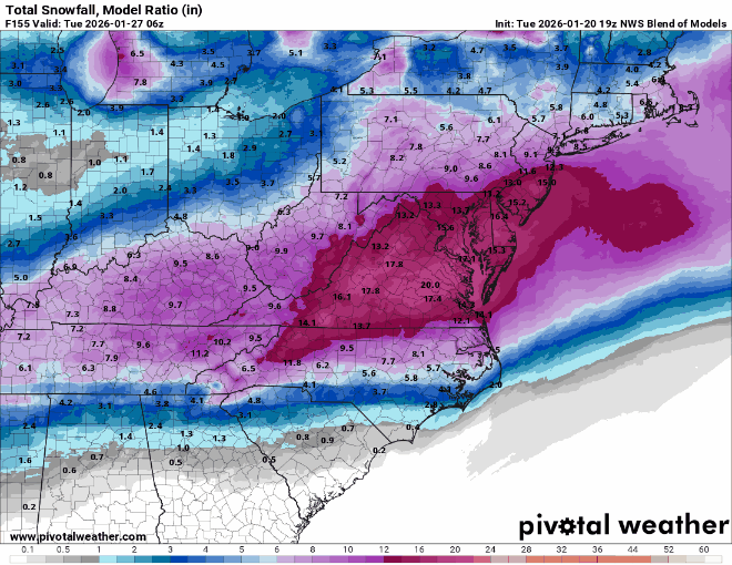
I’m gonna say this right now and you can hold me to it; If you are north of the M/D, your average ratios will likely be >13:1 If you are between I-70 and the M/D and west of the fall line, you’re probably between 11-13:1 average. East of fall line in that bracket, probably between 10-12:1 ratio average. South of I-70 and east of the BR, 9-11:1 average with higher than 11:1 in elevations >800’ BR will be 12-15:1 thanks to elevation East of fall lines out of I-70 latitude, probably 9-11:1 average with best away from coast. Im probably missing some areas, but the key word is AVERAGE!! There will be portions that are better for sure, and the EC shows that very well. Classic ratio distribution. Keep this in mind and use QPF to create your own top and bottom ends of your snow range.
-
Just saying for many of us in here, the front end portion of the storm on the EC was still a warning level event before the coastal enhancement. SWFE’s around here tend to surprise in a positive direction. Keep that in mind. Idk if you guys remember the forecasts going into Feb 2014, but we obliterated the forecasts on the SWF portion of that storm and exceeded expectations. This storm has that type of potential. That connection of moisture between 925-500mb is incredibly healthy. We just need the general synoptics to hold. This is a southern stream addition we haven’t had in a while. That will make a difference to who gets hit the hardest.
-
Yes, Thursday will be everything coming into the NA RAOB network. However, we are putting recon schedules out to sample the area in the Pacific that will play an importance with the digging energy in the coming days. We will have plenty of sampling going on. N/S is probably the area to keep close eye on, although that seems to be well documented on guidance right now.