MillvilleWx
-
Posts
5,538 -
Joined
-
Last visited
Content Type
Profiles
Blogs
Forums
American Weather
Media Demo
Store
Gallery
Everything posted by MillvilleWx
-

12/14: Sunday funday? Will the south win again?
MillvilleWx replied to TSSN+'s topic in Mid Atlantic
North-central NJ -
12/14: Sunday funday? Will the south win again?
MillvilleWx replied to TSSN+'s topic in Mid Atlantic
He ain’t wrong. I think 5-9” is in the cards for some from South Jersey back to NE MD. I’ll be at the shore for this one. I want to be able to drive around in it with my Dad and enjoy it, so I’m hoping for 1-2” that falls a light to moderate clip. Time to enjoy what falls! Good luck to all, and remember, all December snow is good snow -
Actually, the model in the 500mb progs has been pretty decent overall, but it's not a normal dynamical model, so it doesn't follow the same exact principles and biases that other models do. It is basically one giant analog that uses historical variance and comes out with a progression that makes sense given recent patterns. The issue with the AIFS and AIFS ensemble is it doesn't account for those dynamical inputs that provide more detailed QPF distributions and more advanced ptype algorithms. I use it for a proxy in QPF (Spatial) and the mean 500mb pattern. The rest you have to use your meteorology and some real time context for what could transpire given the forecast pattern evolution. You have to be careful with the AI at long leads as the model will still be subject to variability due to temporal regulation and the idea of chaos increasing in a dynamical fluid (Atmosphere) as we move out in time.
-
I still trust the GFS over the Ravens pass rush….
-
They marked me as a "Trained Spotter" in their PNS report instead of NWS Employee as well. I'll have a talk with a few of their mets because this is ridiculous.
-
12/5: 1.1" Season Total: 1.1"
-
I wish I could take credit for that, but twas not me! I was outlining the banding potential with this system and how there would be two main areas over the sub. This little surprise is indicative of a mid-level maxima scooting through with influence at the surface from a weak inverted trough axis off the Mid Atlantic coast. We analyzed one off DE this evening on the 03z surface analysis which I looked over. Nice little surprise!
-
Major congratulations my man!! Amazing day
-
Ended up with 1.1” in Londontowne. Most of it fell while I was asleep. Nice to wake up to. Feels good to be on the board!!
-
You're getting it!! Static presentations tell some of the story, but how the whole evolution materializes, or is expected to materialize paints the full picture. You'll learn a lot more about jet dynamics as you work through classes. The derivations will help give you an understanding of the "why", even though they can be a bear to tackle (Math portion). Contextual models will also help as well, which I know they'll go through. You are doing great and really find interest in this, so keep up the great work and never stop asking questions
-
Very close, yes! There can be shifts in the latitudinal alignment of the 700-500mb FGEN and you can tell positioning potential based on advection regime by assessing the wind field and height contours. Notice across MD/NoVA, the winds are parallel to the height field with a touch more perpendicular trait further south. This is a relatively zonal scheme, however the passage of the mid-level disturbance allows for a bit of amplitude downstream of the mean trough as it migrates eastward. That's why as the storm materializes and move east-northeast, there's a bit of a southwest to northeast slope of the QPF field as we head into morning with a bit more latitudinal gain in the FGEN placement. It comes down to that minor downstream amplification still positioned within the RER of the retreating upper jet over the Northeast. The static image you provided would make it SEEM like that would be the case, but the evolution of the synoptic pattern will allow for just enough general amplitude to have things shift up into our hoods to give us some fun. Fluid dynamics is a treat, isn't it?
-
As EJ eluded too, take a look at the 850mb temps. and also take a look at 925mb while you are at it too because the layer of greatest importance lies within the 925-700mb zone for this setup. Winds within 850mb are convergent across the Mid Atlantic, especially along and east of the BR. There's a nice 160+ kt jet max just off to our north with RER dynamics positioned over the Central and Southern Mid Atlantic. This is important in terms of ascent being maximized within the DGZ, allowing for better dendritic growth regimes to materialize with banding structures likely situated within the stronger 850mb FGEN and up around 700-500mb FGEN maxima due to the stronger mid-level vorticity advection passing to the south of the M/D. Where these two areas intersect will be the stripe of the higher totals, mainly southwest VA through true Central VA, perhaps sneaking into far SoMD. Further north, the 850mb FGEN will be the main show and where that sets up will likely spur some 1-2" totals which looks to be along and south of Rt50, and maybe as far north as I-70, although it will be close! Fun little setup here! Wish we had a little more amplitude in the mid-level pattern, but beggars can't be choosers!
-
Wow! That is one of the nicer soundings you'll see with this one. Looks like winter will be knocking by morning for many. Along and south of Rt50 may be the spot now, so a bit further north expansion comparted to previous thinking. I'll be on night shift till 6am, so probably driving home in it. Looking forward to the festive feel!
-
Congratulations!! The birth of a future weather weenie
-
Seems like a general consensus being drummed up via CAMs this morning. Feel like flurries will reach north of I-70 with measurable (0.1”+) probably around I-70 with a small incremental increase the further south you go. Rt50 is likely the dividing line for where 1” is possible in this scenario across VA/MD. Slightly better chance north of Rt50 as you get into Sussex County DE. Best chance will be I-66 on south with 2-4” local to 6” across Southwest VA true Central VA, albeit lower side of things as you come off the terrain. System struggling to gain latitude and the drier antecedent airmass will be the main issue for majority of the sub. Bob Chill and Wxdude-ville will have the best opportunity here. CVille folks will have a nice little snowfall to start the season as well.
-
Looked at everything last night and decided not to head north for snow. Went to get car serviced instead. Was a nasty, raw morning here in the lowlands. Still getting a cold 39° rain here. We needed it, so I’ll take it. Sad to see the WAA win out, but that’s the sad truth about these types of setups. If the high is moving out and the antecedent airmass is marginal, probably should hedge on the lower end. This setup in January probably yields one heck of a mess, but the northern tier gets slammed. Till next time!
-
Adding to the list!! Thanks Mappy
-
This.... Models are going to struggle with this aspect and the near isothermal layer between sfc-700mb is going to be tough to resolve and likely will be a nowcast situation. Heavier precip in the onset will help to mitigate the WAA regime within the PBL, so intensity will play a pretty big role in this for Central MD along and south of the area you mentioned. Areas up near the M/D with more elevation will likely stay snow longer, as is customary. This is a textbook case of climo likely being the hedge when it comes to the forecast.
-
Oh wow, thanks! I will be in that area from Waynesboro over to your hood, so somewhere in there I will be stopping. Always great to have options. Thanks to you and Mitch for the suggestions!
-
I am making a note of that right now!! If the radar looks good there, I will 100% post up right there. Anyone is welcome to join if they please too!
-
Actually, this is still considered early for the region for appreciable snowfall. FDK average in December is still only like 3-4" with peak snow climo opening end of the month. We have 1-2" forecast for your area right now, so it should look pretty in those parts come Tuesday morning. I'll be out and about up towards the PA line enjoying the snowfall. Thinking of where to post up. Want to get a nice breakfast at a diner and watch the snow fall
- 750 replies
-
- 10
-

-

-
@wxmvpete and I are working the WPC Winter desks this morning, so you'll see what we drum up here by the afternoon. Interesting forecast for sure, but fun to be able to have the hands in the first potential event of the season for parts of the sub
- 750 replies
-
- 21
-
-
-

-
Yeah, we noticed that looking at the MSLP member plots and looking at the ptype output. It's skewed high and some gaudier members in there too. I think what the AIFS and ECWMF deterministic are showing are pretty good agreement with the op more on the drier side in the northwest edge of the precip field. EC has had a drier bias in that area over the past few years and beefs up a bit as move closer. Unless there's a purely synoptic based reasoning for that sharper delineation on the northwest edge of a cyclone, there will likely be a small correction. I think we are closing in on a more reputable solution.
-
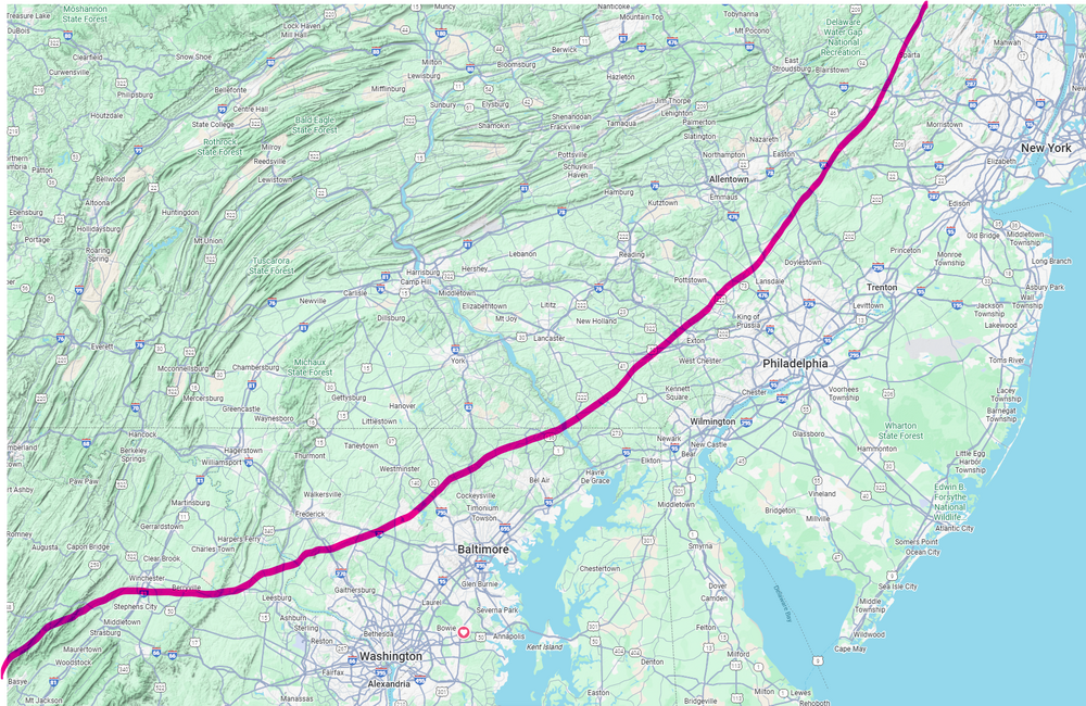
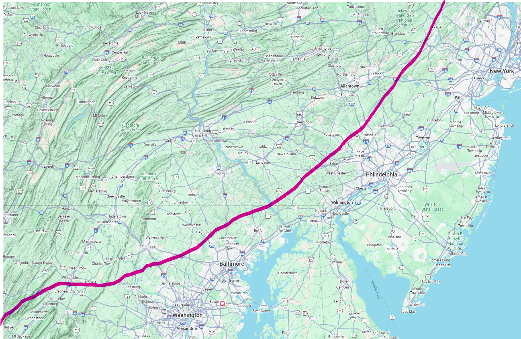
That area is where the drop in elevation starts out of Winchester. Could very well be wrong, but this setup has happened historically, much to your chagrin, so I went that route. I do think you could see an inch out that way, but better chance just north.
-
Extremely meteorological forecast of where I think the best chance to score 1" of snow from the event could end up. If you are north of the red line, potential. South, probably not. EXTREMELY METEOROLOGICAL