

MillvilleWx
-
Posts
5,530 -
Joined
-
Last visited
Content Type
Profiles
Blogs
Forums
American Weather
Media Demo
Store
Gallery
Everything posted by MillvilleWx
-
Crazy month when it starts raining wives.
- 1,378 replies
-
- 7
-

-
- severe
- thunderstorms
- (and 2 more)
-
Tornadic circulation about to pass south of my place in Edgewater. Looks like we’ll get smoked by rain again there. Needed 1.21” to eclipse 9” for the month. Have a good shot I feel. Man, what a month for rainfall around here.
-
That tornado warned storm near Wheaton is nasty. There might be something on the ground presently or really close to dropping.
-
Nice forecast update by my colleague. I had the Slight Risk through Eastern KY, WV, and Central MD this morning. With the latest CAMs, Philly got on board. They wanted to see one more suite before wanting the higher risk, so I backed off the Philly area on initial collaboration. Looks like tomorrow will bring the goods
-
Considering your historical record dates fairly far back, having a record would be very impressive for the month. I hope we can get slammed and put the kibosh on the drought once and for all for at least half the region.
-
Correct and I'll be taking a closer look at it tonight. NAM Nest is the most aggressive with the convective component of the forecast, but it's plausible it has the right idea. There will be a narrow corridor of heavy rainfall. Curious to see if it trends further on other guidance for the region. The update will be out overnight around 330-4AM, so check in tomorrow morning for the update. Also, last night shift for me tonight in the stretch. Stoked!
- 1,378 replies
-
- 11
-

-
- severe
- thunderstorms
- (and 2 more)
-
With the final bit of true rain moving out, final tally is 1.82" at mi casa. A little more extra than what I was anticipating with my previous post. I'll gladly take it. Hi/Lo 62/52 so far with the temp currently at 59. Incredible stretch of weather the past few weeks. Incredible 7.89" of rain this month with more to come on Friday. A run at 9" is certainly plausible
-
1.64” here on the western shore of the Bay. Glorious sleeping weather. Light rain continues, but probably only going to add a bit before it ends. Hi/Low so far is 62/52. Currently 58°
-
Not much rain in my hood today with only 0.03" in the gauge. High was 71 briefly, but sank to the 60s after the rain this afternoon hit and never recovered. Low was a cool 52, which was great for sleeping on nights. Another wet day over the region tomorrow, a generous offering to us night shifters. Only one left after tonight. Congrats to those getting good rain today!
-
One of the positives of baseball....marathon, not a sprint. No, I don't think we're gonna turn it around enough, but we have the talent to AT LEAST get the bats to wake up some. Pitching will kill us for the long term, but we weren't THIS bad imo. Weirder things have happened, but I'm just glad they figured out how to string some good baseball together instead of 1 game followed by 4+ egregious performances.
-
After some clouds this morning (Which while I'm on night shifts I'm thankful for), it cleared up nicely this afternoon and provided another picture perfect day to round out an immaculate weekend. 73/60 so far for the high/low, but the low might go down here soon with temps already at 62 at mi casa. It'll be close! But the high of 73 was beautiful, just in time for my afternoon walk. I hope everyone got out and enjoyed as much as they could. Edit: Dropped to 56 for the low. Beautiful
-
Another incredible day for the lowlands. 73/50 today with mostly sunny skies. This afternoon's walk was immaculate again. This is by far one of the nicest Memorial Weekends in a long while around here. Tomorrow, another beauty in the works! Upper 40s to mid-50s for lows and low to mid-70s for highs with some upper 70s in spots. Mostly sunny by the afternoon. Glorious
-
Another beautiful day for late May! Temps 69/52 for the official Hi/Low for mi casa Currently 61F and dropping slowly. I thoroughly enjoyed driving to work with the windows down this evening. Another nice day in store for tomorrow.
-
I hope so. We are due for a cooler stretch of summer. The things I would do for a 2014 summer redux....
-
Despite the fact I'm on nights, this weekend is shaping up to be one of the better Memorial Weekends in recent memory. Sunny, temps that won't be excruciating, a nice breeze (Little breezier tomorrow compared to Sunday), and the May sun will keep it feeling warm. I'm going to try to enjoy the outdoors as much as I can. Today's High was 69F today....Already down into the 50s.
-
0.78" Yesterday (5/21) 0.39" Today (5/22) Event Total: 1.17" Not bad. I'll take that and run. Everything is really green right now within the neighborhood. Walked in the light rain this afternoon. Couldn't complain Currently 56/54
-
Happy Birthday @H2O!! Hopefully you get that pony you asked for
-
Just got back from a 6.5 mile walk. Absolutely beautiful out today! Get out and enjoy it with the next few days coming. This will be a nice soaking rain once again.
-
Ssssshhhhhhhhhhhhhhhhhhhhhhhhh
-
This would be very acceptable. A soaking rain that's not too light or too heavy would do wonders for vegetation. We've really greened up over a lot of the region due to the past few weeks. This would help further. Additional periods to monitor will be Tue/Wed next week and next weekend for more rain. We need to take every drop we can before the summer sets in.
-
1.39” of rain today at mi casa. Got absolutely smoked between 6-640 from the line. Rain rate max was 2.56”/hr. 1.1” fell in 35 min. Great day of rain and thunder around here. Feel for those that sadly have to deal with tree damage. The consequence of these things blowing through. Sterling and Mount Holly were plenty busy today.
-
There were some pretty solid indications of warm rain processes being intertwined with standard mid-latitude dynamics that helped create a pretty hefty rainfall footprint across the region. Not as connected today, but PWATs remain pretty high with IAD coming in around the 90th percentile for the daily 12z sounding.
-
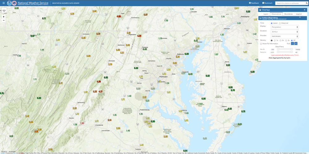
Obviously some of these stations are incorrect, but a majority did a great job capturing the event. The winner was down in the Central BR with over 7" for the primary event (Sawmill Ridge). Those RAWS stations are very reputable and maintained by the Forest Service. BWI at almost 3" is wild. It absolutely dumped buckets there last night.
-
2.56” for main event here in Londontowne. Man was this needed. Thank goodness
-
0.69" so far in my neighborhood. About to head home from work. Hopefully pick up a nice dousing overnight.


