MillvilleWx
-
Posts
5,538 -
Joined
-
Last visited
Content Type
Profiles
Blogs
Forums
American Weather
Media Demo
Store
Gallery
Everything posted by MillvilleWx
-

Jan 24-26 Weekend Snow and Sleetfest Model Thread Part Tres
MillvilleWx replied to H2O's topic in Mid Atlantic
Yeah, like I told Snowen, I have not paid attention to ZR much, so apologies for not really having an answer on that. I've been focused on the snow and sleet like crazy, so I can't give a great answer. I'll say this, any freezing rain will accrete very very efficiently with these temperatures. I think most here stay in the low to mid-20s MAX. Only east of the Bay and far southern MD will break 26F imo. It's going to be really hard to scour out. -
Jan 24-26 Weekend Snow and Sleetfest Model Thread Part Tres
MillvilleWx replied to H2O's topic in Mid Atlantic
I want to be so wrong, that people look at me and go, "Man, isn't that that guy who was really wrong and sucks at forecasting? Don't even look his way, you might catch the Wrong..." -
Jan 24-26 Weekend Snow and Sleetfest Model Thread Part Tres
MillvilleWx replied to H2O's topic in Mid Atlantic
Honestly, have not been paying attention enough to the ZR portion of the storm, so I don't want to give bad information. I think snow and sleet will be the majority, but I'm really keeping an eye on the NAM Nest and how other hi-res respond tomorrow. The school will likely have generator power, so I would stay. I stayed for the big ice storm at Millersville in 2014 and it was awesome. Incredible pictures came from that one. Just stay safe down there! -
Jan 24-26 Weekend Snow and Sleetfest Model Thread Part Tres
MillvilleWx replied to H2O's topic in Mid Atlantic
First Call Forecast Went with a EC/AIFS/AIGFS blend with a stronger push on the FGEN, front end thump to help with many on Sunday AM, but I am very very wary of the NAM Nest right now, so will revise if necessary tomorrow. For now, I'm sticking with this. I do think banding will be impressive area wide. Just a matter of how thermals behave. Going to be a big day of trend monitoring tomorrow. Also, the lines are imperfect. I wish I had a better program, but utilized Microsoft Designer and it wasn't too bad. Wil work with it.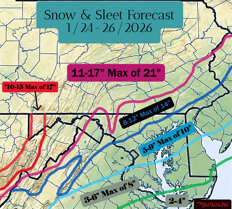
-
Jan 24-26 Weekend Snow and Sleetfest Model Thread Part Tres
MillvilleWx replied to H2O's topic in Mid Atlantic
Internal model snow ratio map is even better than Kuchera. It’s very hefty with the front end thump. Wish it wasn’t at range, but something we’ll be monitoring is the QPF distribution on guidance to the lead up. If they stay juiced, that will be a major plus for snowfall and beating back the mixing line due to evaporative cooling in the layer between 850-700mb.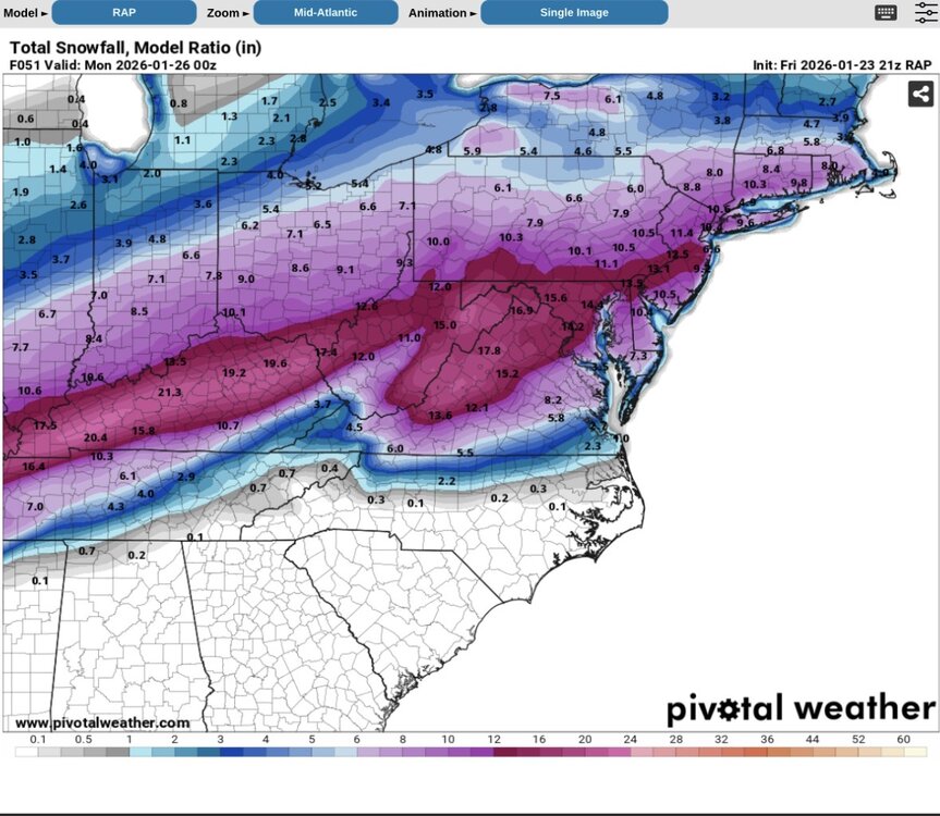
-
Jan 24-26 Weekend Snow and Sleetfest Model Thread Part Tres
MillvilleWx replied to H2O's topic in Mid Atlantic
This is correct. Wildly consistent -
January 24-26: Miracle or Mirage JV/Banter Thread!
MillvilleWx replied to SnowenOutThere's topic in Mid Atlantic
Right now I like 8-14” for us, but REALLY need to see the NAM Nest not lead the way with torched thermals. Still a nice front end thump and there will be surprises! -
January 24-26: Miracle or Mirage JV/Banter Thread!
MillvilleWx replied to SnowenOutThere's topic in Mid Atlantic
I remember hearing about your area up to Red Lion were like a war zone with the damage on trees and power lines. No bueno. -
Jan 24-26 Weekend Snow and Sleetfest Model Thread Part Tres
MillvilleWx replied to H2O's topic in Mid Atlantic
Feb 2014, night after the Super Bowl ice storm in southern PA and northern MD was my worst. That was crazy. Rain and 21° to start. School was out next day and damage all over the place. -
Jan 24-26 Weekend Snow and Sleetfest Model Thread Part Tres
MillvilleWx replied to H2O's topic in Mid Atlantic
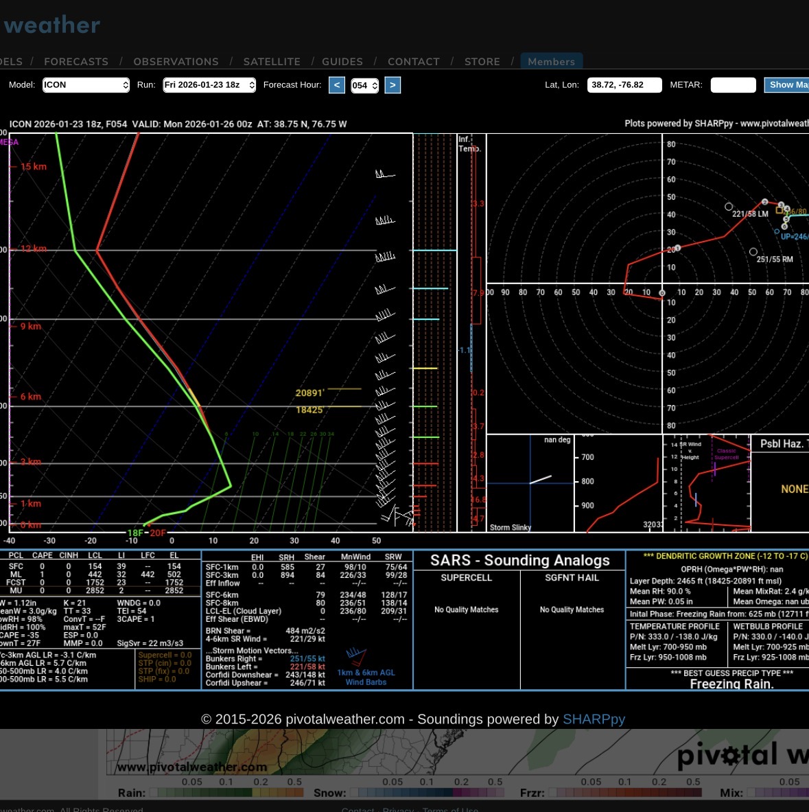
This is a snap shot of what I was talking about with the freezing rain sounding. This was near the beltway in PG county. You definitely don’t want this sounding to come to fruition.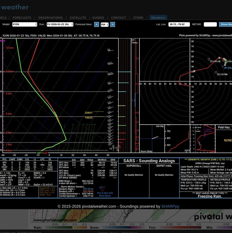
-
Jan 24-26 Weekend Snow and Sleetfest Model Thread Part Tres
MillvilleWx replied to H2O's topic in Mid Atlantic
Actually, even worse. It could be freezing rain with temps in the teens for some looking at soundings on pivotal. Good gravy. -
Jan 24-26 Weekend Snow and Sleetfest Model Thread Part Tres
MillvilleWx replied to H2O's topic in Mid Atlantic
It’s close to sleet for a lot of people, but part of it is freezing rain with temps in the low to mid-20s. That would actually be a disaster and we would have more problems than we could ever want. -
Jan 24-26 Weekend Snow and Sleetfest Model Thread Part Tres
MillvilleWx replied to H2O's topic in Mid Atlantic
Lost about 4 inches, but legit everyone lost 4-6” from that run until you got north of I-78 where they gained 4-6”. It was because of the 7H and 85H evolution. Just waaaaay too aggressive for here and the warm nose would catapult its way north. Provided a trend graphic below. It’s been bouncing around like that rubber playground ball we used to use. Still trying to figure itself out, so wouldn’t sweat it. I loved the run up until 18z, then it went agro. The synoptic evolution would cancel that. Surface remains cold af though. It was actually a worse case scenario regarding impact. That would be hell around here and travel would hit an impasse.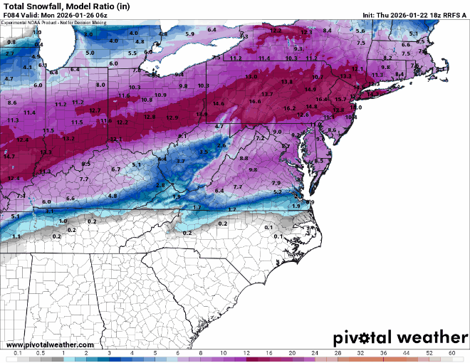
-
Jan 24-26 Weekend Snow and Sleetfest Model Thread Part Tres
MillvilleWx replied to H2O's topic in Mid Atlantic
I still have 10-12” for the northwest crew using the internal snow ratio calculation the RRFS uses if it’s any consolation. The crazy thing was how far the warm nose blasted in PA. That was wild. Freezing rain all the way past the turnpike -
Jan 24-26 Weekend Snow and Sleetfest Model Thread Part Tres
MillvilleWx replied to H2O's topic in Mid Atlantic
This is the biggest issue for the Nest so far. It’s just so weak comparitively with the WAA precip, and precip just in general. Still time, but I have seen the Nest do this before with synoptic scale QPF distribution. Too light overall, but still shows the ultra heavy precip depictions in the mountains as it struggles with capping magnitude of upslope flow. -
Jan 24-26 Weekend Snow and Sleetfest Model Thread Part Tres
MillvilleWx replied to H2O's topic in Mid Atlantic
Just looked at model comparison tool on Pivotal at hr 42 and went through every model sounding I could get for DCA and NoVA. The NAM 12km is the warmest of all and most aggressive with the warm nose push. Every model, including the 12z NAM Nest is south of it, and by 30+ miles. The key this run was a much better precip shield on the WAA pattern leading in. As @psuhoffman alluded to, that is important and a good sign across all guidance that seemed to bump precip in that time for 12z runs with the NAM the only one lagging behind. It’s playing catch up in that instance, which is fine at this lead. It’s a solid signal overall. -
I guess. He just literally never won anything. Even at Texas Tech as coach. I just hate people who can’t win the big game. I will say he was severely handicapped this season. Maybe with a mobile QB like he had with Daniels, he can make it work. I’ll be skeptical until I’m not lol So long as we don’t hire Matt Nagy….
-
I don’t know why people love Kliff so much. Dude has never won a damn thing. I hate his scheme, but if Lamar supports it, he might know something I don’t (Definitely knows more than me). I just can’t stand him.
-
Jan 24-26 Weekend Snow and Sleetfest Model Thread Part Tres
MillvilleWx replied to H2O's topic in Mid Atlantic
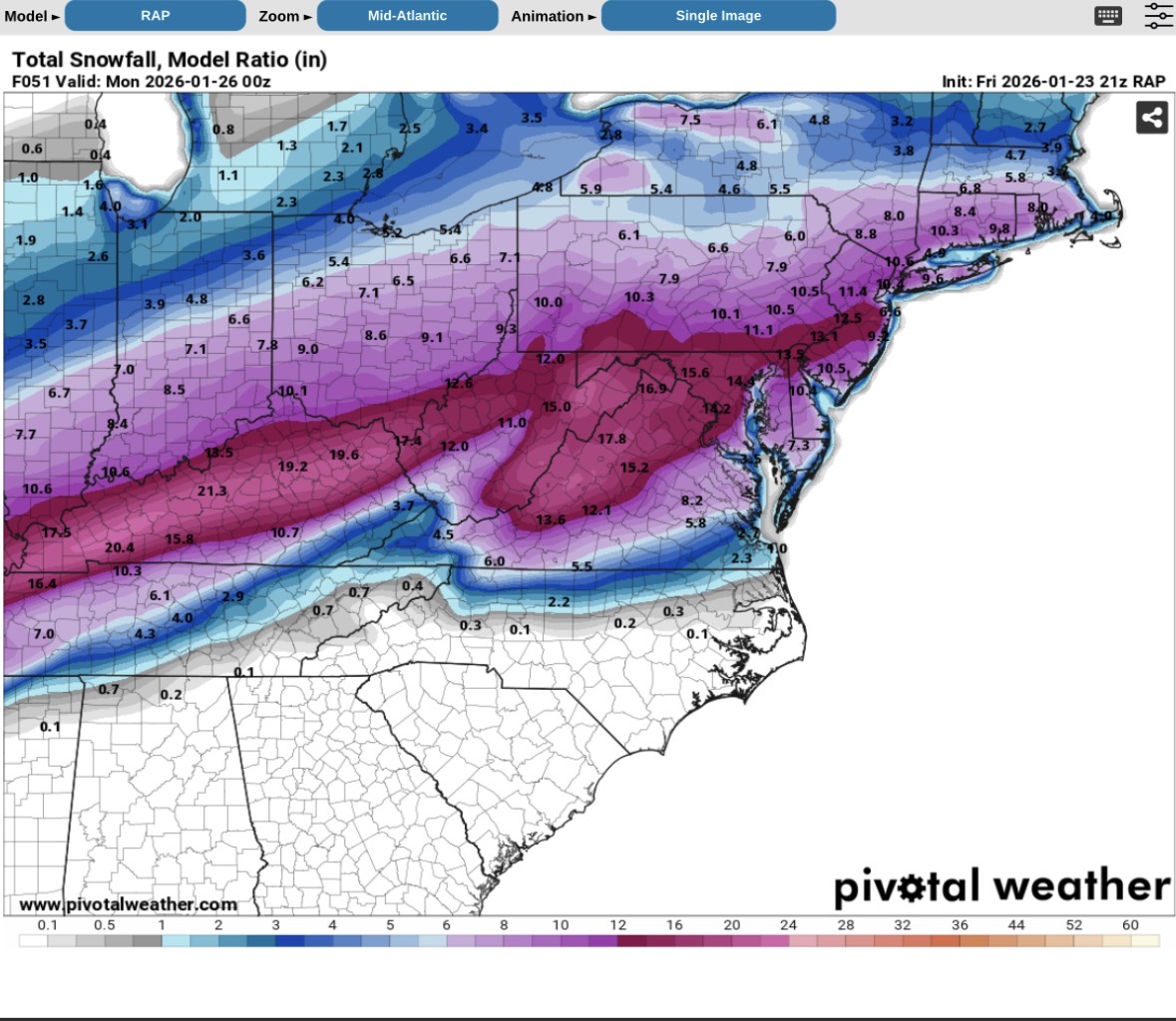
The northern and northwestern crew will likely see 15-20:1 to start and probably continue for several hours until after the time frame between 12-15z. Then it’ll start coming back down, but so long as it doesn’t turn to sleet, ratios will probably be between 10-12:1. I’m hoping for some incredible banding across the region with this one. The FGEN fields are off the charts, sans the NAM parent. I hope the NAM Nest dry bias in these setups at range is the culprit. I’ll take it more seriously tomorrow. The rest of the 12z suite was fantastic imo. Still time to parse details. -
NAM’s are hands down the most aggressive at the handling of the thermal profiles with the warm nose marching northward faster than any other guidance. I do think it’ll come in quick, but perhaps the NAM is too aggressive at this lead. NAM Nest wheelhouse starts tonight and improves stepping through time closer to the event. Curious to see how it responds. The margins are thin when it comes to the handling of the warm nose between 850-700mb.
-
True. Definitely did a broad brush with my VA comment. I think your area in the BR should cash a good amount of snow before any flip. It’ll be quite a storm down there. Juiced QPF for sure. I still think you’ll end up with 6-10” for your elevation before a flip.
-
It was to a degree. They expected some sleet but also more snow and it became evident it was going to be a monster sleet storm inside 24hrs. Models weren’t as good back then, so it happened, but there was always an indication. Bottom line is WAA aloft tends to be robust when you have phasing elements well to our west. This wasn’t textbook for us. It was back further west, but we have serious cold leading in, so unlike other setups where the ground temps even warm to freezing or slightly above, they’ll stay frigid, so impacts will still be high. It’ll be more sleet than we care for at this rate, and it just is what it is. Need that front end piece to ramp up and really deliver to fight back the warm nose intrusion between 850-700mb, which could still happen.
-
It’s loud, I can tell you that much. Have been through a couple. Friends at college went through VDay 2007 up in PA with 5+” of sleet. They said it sounded like a barrage of BB’s for hours on end hitting the house. Crazy
-
That’s actually been the one thing that’s driving me nuts. I know @WxUSAF has joked about it in recent days, but sort of true at this point. Is what it is. I think this will end up being a monster sleet bomb south of I-66 at this juncture. Snow will rip in VA for a time though, so it’ll be one heck of a mess down there.
-
My colleagues at LWX are way too high on snow/sleet accums right now imo. NAM Nest is still outside its full useful range, but not exactly a beacon of positivity on that 12z run. We shall see. That front end thump trending later has been a boon to this forecast. That needed to show up between 00-06z and not 06-12z. I’ll have a forecast later today. Fighting a monster headache this morning.